A surge of mud was reported at Swift Creek last week after a heavy spring rain Thursday. I joined Western Washington University geologists Scott Linneman, Doug Clark and Chris Suczek to check it out.
Our first stop was at the Goodwin Road bridge over Swift Creek.

This reach of Swift Creek is agrading due to the huge sediment load from the landslide. The very milky stream is from finely ground rock from the landslide. This light colored clay sized material in suspension is full of asbestos fibers. Hence, maintaining the bridge has become a problem. The asbestos is natural, but legally becomes a hazard once handled. The asbestos laws did not anticipate anything like Swift Creek.
Our next stop was at a concrete weir that that was constructed near the outlet from the mountain front through which the creek flows through.

The weir was built it monitor stream flow levels and also to monitor turbidity. The log in the picture has a laser that measures the height of the water and a turbidity meter is located within the stream. While the stream is very cloudy with clay to very fine sand, we noted that golf ball sized cobbles were bouncing through the weir during our visit.
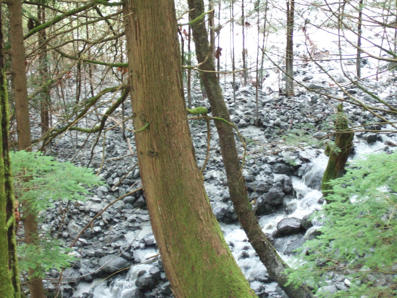
From the weir we headed up to the end of the end of the gravel road and started our walk up the cobble and boulder lined creek towards the toe of the landslide. The cobbles and boulders in this stream will strain any petrologist or mineralogist. I have made this walk several times and it hurts my brain to think about not only all the mineralogy I have forgotten, but stuff I have never seen as well. The cobbles contain a diverse mix from the melanged slices of faulted deep crustal rocks that are part of this big bedrock failure, strange ancient soil horizon mineralogy that formed over the deeply weathered ultramafite rocks, various cobbles and boulders derived from the overlying Huntingdon Formation that is collapsing onto the slide, and various glacial erratics all jumbled together.
One of the first cobbles I observed is one that is familiar, a dark greenish to black ultramafite cobble with an orange weathered rind. This nearly identical unit of ultramafite underlies the steep slopes of the inner gorge of the next drainage to the south on Sumas Mounatin. It is a great example of just because a rock is hard does not mean that it will not disintegrate when exposed on the surface to weather.
After rolling and bouncing down the stream channel this cobble of hard rock has sat on the surface for a couple of years. I gave this rock a bit of a kick with my foot.


The cobble easily broke. Other boulders of the same rock type that rolled and bounced down the stream as coherent boulders can be torn apart with bare hands after only a year or two of being exposed to wetting and drying and freeze and thaw. A close look at the rock shows it shot full of veins of a white mineral. This is a classic serpentinized ultramafite only in this case the serpentine veins have been partially altered to a clay that readily breaks the rock apart.

While I have some familiarity with the above unit, I am not so sure about a fair bit of the other rock types out of the ultramafite. This rocks get a bit weird and includes white garnet and blue talc along with some very unusual magmatic differentiation.


The ultramafite bedrock that is the unit causing the big Swift Creek landslide is Jurassic in age (145 to 200 million years). The ultramfic rock is overlain by a conglomerate unit of the Huntingdon Formation, an approximately 40 million year old sedimentary unit deposited directly on top of deeply weathered ultramafite at the Swift Creek site.

Outcrop of Huntingdon Formation adjacent to the very milky Swift Creek
We arrived at the toe of the landslide and I took the picture below from a location very nearly the same as the location as one in October 2011 (included for comparison).

Swift Creek slide, April 2012
One challenge of viewing this image is the stream of water flowing down the middle of the slide.
The stream is so turbid is blends into the adjoining soil.

Toe of Swift Creek Slide, October 2011 with no stream on slide surface
The shape of the toe was not hugely different between the April 2012 and October 2011 visits; however, a bit of the toe has gone missing - washed out and down the creek to the low lands below. A more noticeable difference was the material deposited across the forest floor to the south of the main creek channel. This deposit is a new deposit since my October 2011 visit and while there was one stream channel at that time there are currently multiple channels.

Trail to LiDAR platform

Scott Linneman looks out over the toe of the slide at remote camera site
This remote camera site takes pictures of the slide and has helped greatly in understanding this beast of a slide. See the movie HERE.


No comments:
Post a Comment