Sunday, June 29, 2014

Ice Age Floods, DEM and Lake Lewis

In an effort to get a handle on some land forms, I set the approximately 350 meter contour and below as blue. The elevation is the approximate height of the highest overflow path at Wallula Gap, the narrow point in the above digital elevation map where the Columbia River cuts through the Horse Heaven Hills. The contour approximates shores of Lake Lewis, the temporary lake that backed up behind the narrow gap during the ice age floods. The pool of blue down stream of the gap would not have filled that deep with flood water; however, the water did back up in that area as well due to the constriction in the Columbia River Gorger further down stream off the map.

Wallula Gap with highest flood overflow channel marked with blue on the left upon which the lake level projection is based.

Islands formed for brief periods along the fist anticlinal ridge south and west of Kennewick
 
Snipes Mountain a ridge within the Yakima Valley west of Sunnyside and east of Granger stuck up above the water in this scenario.
 
The water backed up the Yakima River including through Union Gap forming a pool in what is now Yakima and perhaps a small pool north of Selah Gap. The flood matches fairly well the inundation in the Yakima area.

 The water pooled to the east as well inundating the Walla Walla valley.

Water also backed up the Snake River canyon all the way into Idaho on the east of the above map. Keep in mind water from Lake Missoula was likely still poring into the lake from the north. The river north of the Snake is the Palouse and its old channel, now Washtucna Coulee. That sharp canal-like line connecting the Palouse to the Snake is the current route of the Palouse as it follows a joint carved by the flood (the-palouse-river-leaves-its-valley).  The back of water portrayed in the image is matched by thick silt units that fill the valley of the lower Tucannon River, a tributary that flows into the Snake from the south. 
 
The back up from Wallula Gap extended far up stream. This image is the Columbia River at Wenatchee with water backed up the Wenatchee River into the Cascades. The blue area extending across the lower right is Moses Coulee, one of the numerous flood route paths. 

Tuesday, June 24, 2014

County Tax Dollars to Protect Private Land

A few weeks back, the Whatcom County Council approved developing a plan to use County Flood Tax dollars to shore up a river bank revetment to protect private property whatcom-council-oks-plan-to-save-strawberry-field. The project funding is controversial for a few reasons and perhaps I'll add to it. Full disclosure: I am a member of the County Flood Advisory Committee and voted against this project.

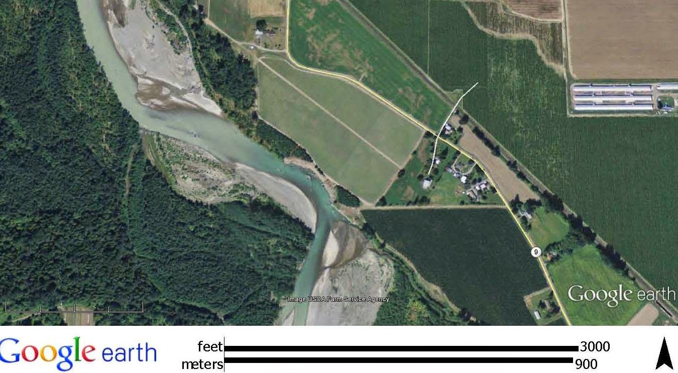
But first a bit of an overview of the erosion location:

AERIAL/MAP HERE

This aerial view is from 2005. River flow direction is indicated with blue arrow. This section of river bank had previously been lined with rocks, but as can be seen, a small section had begun to unravel and needed to be repaired.

By 2007 the small initial failure had expanded, had not been repaired and the damaged section had begun to expand. And note that the river channel was migrating such that the main flow where the river encountered the rock revetment on the river bank was beginning to shift toward the point of damage.  

By 2011, the last Google earth image, the river flow was now aimed directly at the bank where the previous small section had been damaged.

At this point the property owner had begun to do repairs using a combination of logs and rock as can be seen in the above image;  however, the delay of doing the repairs had greatly expanded the area that needed repair and the rocks and amount of material used in the repair was undersized for the project.

Since 2011, the river has demolished the inadequately constructed structure and erosion reached into the farm field.


The point of erosion has been progressively moving downstream. The above picture was taken in Spring 2014 and shows the main point of erosion has shifted. An earlier area of erosion is now not confronted by the main flow of the river. 


The idea that the County Flood District would fund the repair work was first raised in 2009. The project was reviewed at that time by the County Flood Advisory Committee Project Review Subcommittee. The project was scored by the committee and ranked very low relative to other potential projects. Hence, this low ranking project would very likely not be funded.

Projects that are designed to protect private property generally rank low. But if it appears that the erosion will lead to a threat to public property or put life and safety at risk, the scoring will be higher and the project may rank higher. Loss of farm land does get some consideration if the erosion will lead to loss of large tracts of farm land and more points are added to the score. There have been locations along the river where, if erosion continued, hundreds of acres of active farm land would be at risk - that is not the case at this site. Nor was it the case that the erosion posed a risk to public property or posed a life and safety risk.

In this case, none of the big threats that would move the score up were present. The project would protect only one private parcel. Public property was not at risk and the erosion and loss of farm land was relatively small scale and very localized to the individual property.

Hence, the private property owner was turned down for public funding in 2009. Unfortunately for the owner, the repair project was started too late and was not adequately sized to hold back the erosion.

The property owner then reapplied for the county to use tax dollars to fund a project to stop the erosion, but this time they have rallied supporters. They arranged field trips for County Council members and got various farmers to speak in favor of the project. Its a hard position to be in as a committee member. Groups of folks want you to fix a problem and you have tax dollars that you can use and it is very hard to say no to a property owner that is loosing land to erosion. Even with a low project score, the advisory Committee opted to vote for approval of going forward with a project to stop the erosion.

I did vote against the project. It really is too bad that as soon as the small damage location took place in 2005 the property owner did not fix the problem when it would have been a small project. The reason the County had come up with a scoring system was to attempt to get away from funding these very types of projects that only benefit a single property owner. My own geologic interpretation as well as that of Herrera is that the focus of erosion will continue to move downstream and that at some point in the next few years the river will move off the bank entirely - at least for awhile.

With the approval to work on this project the County Flood staff have developed a scheme to place large wood structures to be constructed on the bank above the river. If the river erodes to the structures, the structures would act as erosion control points. As the work would be outside the water during installation, permitting will be easier and possibly take place more readily with less mitigation. Of coarse the land owner will give up more land under this scheme and will have to agree to allow the County use of a few acres of land. The cost to do the repair will still cost $750,000. Other alternatives cost upwards to $2 million and require substantial permitting hurdles.

Sunday, June 22, 2014

Water and Las Vegas

I have been following the southwest drought. It does have implications. But this chart via USBR and via JFleck at Inkstain (HERE) may alter ones view. The short interpretation is that you could remove the entire City of Las Vegas and it would not even be close to solving the water problems on the Colorado River.

While Washington State has water policy issues it is rather minor compared to the potential problems on the Colorado River.

Saturday, June 21, 2014

Ranald MacDonald, Japan and Fort George Wright

A notation on the Washington State road map just south of the Midway/Danville US/Canada border crossing indicates Ranald MacDonald's grave. The grave site is within a small cemetery on a terrace above the Kettle River and the grave is marked with a tall granite obelisk. During a visit to the site I noted wreaths of flowers and postcards. The postcards were from Japan and had images of a matching obelisk in Japan in honor of MacDonald.  

Memorial to MacDonald in Nagasaki (Wikipedia)

Ranald was the son of Princess Raven, a daughter of Chief Comcomly of the Chinook Tribe, and Archibald MacDonald, a Hudson Bay Company officer. He is one of my favorite historic figures from the time before Washington State existed. He played a role in opening up trade with Japan by having himself marooned off the Japanese coast. During his time of captivity in Japan he greatly advanced Japanese understanding of English and America. A nice summary of his life and his importance in Japan can be found at http://www.historylink.org/=7291. Regardless of the size of his role in the opening of Japan, he clearly was much admired in Japan and is still admired to this day. 

The reverence of MacDonald in Japan has also been instrumental in preserving a part of Washington history at the former Fort George Wright in Spokane. Fort George Wright replaced the original Fort Spokane which was located 50 miles to the west. The first army battalion at fort consisted of black soldiers who gained local fame in fighting the massive fires of the Big Burn in northern Idaho, western Montana and northeast Washington.

The fort was used by the CCC during the 1930s and served needed space for the massive military buildup during WWII. Post WWII the fort became surplus and was for a time occupied by colleges, but the cost of upkeep and declining enrollment led Fort Wright College to close in 1985.

The Fort has since been taken over as a study abroad branch campus of Mukogawa Women's University as class rooms and dorms. The buildings are now in much better shape and are well maintained, keeping a bit of Washington history in tact.


Learning about Ranald MacDonald is part of the curriculum as could be seen when visiting a classroom building.


Friday, June 20, 2014

Young Seal Season on the Beach

Every late Spring there are public service announcements about leaving baby seals alone if you come across one on the beach. I saw this pup on the shore of the Strait of Juan de Fucca.


I walked right by this pup twice as I was mostly concentrating on the geology of the steep bluff. I would have never seen the young seal but for a fellow beach traveler pointed the pup out.

It makes me wonder how obliviously I have walked by young seals in the past. I came very close to tripping over this one on Marrowstone Island.

Wednesday, June 18, 2014

Emergeny Management Official: Sometimes Massive Mudslides "Just Happen"

"That community did feel safe and they fully understood the risk...."

"Sometimes events that nobody sees just happen"

What I would like to hear: We need to do better.


Monday, June 16, 2014

A Few Other Highlights Far From Washington

A few other notable sites and images from our travels. I find I always learn and gain perspective from traveling.

Every flight means window time trying to figure out where I am and thinking about adventures on the landscape far below. I never tire of seeing the northern latitudes.

Baffin Island and a glaciated landscape with classic valley glaciers and cirques   

A fjord in southern Greenland 

Flooded rice fields west of Milano

The well known history of this volcano (Vesuvius) has not stopped population growth up its sides. But then again the rich soils from this and other volcanoes in the area is partly why this part of Italy is and has been so attractive.
 
Galleria Umberto
If all shopping malls looked like this, I might frequent them more

Monte Bulgheria above Bosco in Cilent

Fishing with Nicoli, Cilento coast

Football with an ocean view in Lentiscosa

Perhaps the best picture I took
Stone circular stair at Certosa San Lorenzo in Padula

Good road food from the bakery and pasta shop in Sapri

Saturday, June 14, 2014

A Few Geology Notes From Southern Italy

Post trip picture sorting I pulled together a few geology pictures besides the geologic-pilgrimage-macellum-of-pozzuoli that demonstrates that landslides are a challenge to many communities and countries. 


This landslide was a slide area I had previously visited, but this time it stopped our progress on the main coastal road of Cilento. The slide area is approximately 1,000 meters wide and continues beyond the area visible. The slide is within turbidite sands and siltstone.
  
In Basalacata slopes and erosion are a current political issue. But landslides and erosion have been a policy issue in this part of Italy for a long time.

Rebuilt section of Pisticci

Former landslide scrap now with retaining wall 

Pisticci has had numerous landslides including a slide in 1688 that killed 330 people. The area destroyed by the slide was rebuilt on the same slope with hopefully better drainage control.


Craco shown above was abandoned in the 1960s after a series of landslides and pending landslides essentially began to tear the town apart.

Wide swaths of Basalacata are underlain by weak expansive clays and with layers of sand. A wet year has caused many new landslides and closed or highly distressed roads throughout the area.


The area is not unlike the badlands of the Dakotas or the Ringold area in Washington State. 

Friday, June 13, 2014

Setback Guidance Language That Should Be Purged

Shoreline development projects above shoreline bluffs around the State of Washington have generally adopted the same county or city code guidance language:

"Minimum setback from top of shoreline bank is as follows: The standard setback for residential structures, including common appurtenant structures such as garages and workshops, shall be thirty (30) feet or one (1) foot for each foot of bank height, whichever is greater. This setback shall be measured from the bank's edge when the bank's height exceeds 10 feet. When the bank's height is less than 10 feet, the setback shall be measured from the ordinary high water mark."

Based on this language, the setback from the top edge of a 90-foot high bluff will be 90 feet from the edge of the bluff. If the bluff is 40 feet high, the setback will be 40 feet. If the bluff is a low bank of perhaps 8 feet, the home can be built within 30 feet of the ordinary high water mark, that is closer to the top edge of the shoreline bluff; if the water line is 15 feet out from the edge of the bluff, the home could be built within 15 feet of of the top edge of the bluff.

I am not a fan of this language as it is fails to take into a variety of variables and fails some simple logic tests.

For example a bluff with an average slope of 45 degrees covered with large straight mature trees and a well built up beach with very low erosion rates is treated the same as a vertical slope with rapid active erosion. Further, if wave action is equal on a 10-foot bluff and a 100-foot bluff, the bluff retreat rate of the 10-foot bluff will be much greater than the bluff retreat rate of a 100-foot bluff simply due to the shear volume of sediment that has to be eroded from the 100-foot bluff relative to the 10-foot bluff. The language fails to reflect variability in the geology.

And think about the low bluff scenario. A low bank will allow the home to be built even closer to edge of the bluff because one can measure from the water line mark. A low bluff will erode much faster than a high bluff everything else being equal if the low bluff is being eroded.

The above said, these setbacks based on general guidance language and can be altered. Typically, or at least hopefully, there is some language in the code either in the shoreline regulations or the critical areas ordinance for geologic hazardous areas that allows for or requires other considerations.

But the language sets up false expectations and a default setback established by the local government that may or may not be protective.

Hence, I am of the view this sort of default language should be scrubbed from hazard codes.   

Thursday, June 12, 2014

Lyons Ferry Bridge has Crossed Two Rivers

The Bridge at Lyons Ferry has crossed two rivers and replaced two ferry crossings during its life. 

Bridge at Lyons Ferry

The bridge at Lyons Ferry is a unique steel cantilever bridge spanning the Snake River just downstream of the confluence with the Palouse River. In the image above the the view is from the northwest looking south. The high soft hills on the horizon are silt deposits from wind blown sediment from the southwest. The sharp dark cliffs are Columbia River Basalt that was scoured by ice-age floods that roared down into the Snake River carving a new route now followed by the Palouse River (the-palouse-river-leaves-its-valley). The bluff between the bedrock cliffs and the river is a huge gravel deflation bar deposited when the ice-age floods surged up the Snake River from the Palouse River.  

This is the second life for this bridge. The bridge was originally built at Vantage across the Columbia River and replaced a ferry at that location.

Same bridge at Vantage 1950s (WDOT)

The construction of Wanapum Dam on the Columbia downstream of Vantage in the late 1950s would inundate the old town of Vantage as well as the bridge, so the bridge was replaced with a new span. This would have happened anyway with the construction of Interstate 90 across the Columbia at Vantage. 

The original bridge was disassembled and put into storage. Yet another dam then played a role in this bridge's story. The construction of Lower Monumental Dam on the Snake River slowed the water flow on the Snake and thus slowed the river current and the cable ferry. The bridge was rebuilt to replace the Lyons ferry in 1968.

Lyons Ferry with railroad bridge to the left

Monday, June 9, 2014

King County Enriching Douglas County Soil

King County produces a lot of crap. After passage and break down through sewer treatment plants in Seattle some of the remaining dry solids are shipped across the mountains to Douglas County dryland farms on the Waterville Plateau.
  
 
The nearly black biosolids stand in sharp contrast to the light brown native glacial soils.
 
 
Dryland farms in Douglas County have been receiving biosolids from King County for over 20 years. 
 

The product is regulated by both Washington State and the EPA with metals being one of the primary concerns. The King County product is very low in metals, and adds nutrients and structure to the soil.

The Boulder Park Project on numerous dryland wheat farms in Douglas County receives about 60% of the biosolids from King County or 68,000 tons. The name Boulder Park is derived from the many large boulders on the glacial drift plains of the Waterville Plateau.