Wednesday, January 31, 2018

White Russians in Northwest Washington

Over the past few years the winter fields of the Skagit and Samish Flats have become progressively whiter. 


Our winter snow geese breed on Wrangel Island in the Russian Arctic and travel down the Pacific coast to winter on Flats as well as on the lowlands of the Fraser and Nooksack Rivers as well as the lower Stillaguamish.


The number of snow geese has been increasing appreciably (WaterfowlPopulationStatusReport17.pdf) and the results have been noticeable in the fields of the Skagit and Samish Flats with multiple large flocks visible on most drives I make across the flats. The above picture was just west of Bayview Road north of Highway 20.

The population has recovered and surpassed the planned population goals. Past over hunting and weather factors had reduced the population, but the number of birds is now causing habitat damage in both the Arctic and on the farm fields. Washington State has expanded goose hunts and has partnered with a number of farmers to allow hunting access on private land as well as the Fish and Wildlife lands (https://wdfw.wa.gov/hunting/snow_goose/)

Monday, January 22, 2018

A Few Comments on the Rattlesnake Ridge Slide

I got a chance to see the Rattlesnake Ridge landslide as I has some work in Yakima. Not really much I can add to understanding this well news covered and monitored slide. However, I will comment that the agencies involved, Washington State Department of Natural Resources, Washington State Department of Transportation and the Yakima County Emergency Planning have been proactive and communicative with this slide. The precautionary approach and scenario planning is how this slide should be managed and that is what is being done.

The Seattle Times (seattletimes.com/can-experts-predict-collapse-at-washingtons-rattlesnake-ridge) has a good article on how the prediction method that is being applied with good quotes from geologists that shed some light on why the date of predicted failure is shifting. Precise predictions of the future tough in any field!

The New York Times also had an article: nytimes/washington-rattlesnake-ridge-landslide

I did have one quibble with NYT article "Even the name of the town, Union Gap, is testament to natural violence: It refers to a huge gash in the ridgeline carved thousands of years ago by a colossal flood from ancient Lake Missoula.".

The "huge gash" is a river gap where the Yakima River has incised through Rattlesnake Ridge. This gap was formed well before the ice age floods. Some of the largest floods did back up into Yakima through this gap, but the modification of the gap by the ice age floods would have been relatively moderate.

I did like the end of the NYT article. While various scenarios as to the size of the slide have been considered, Steven Slaughter with the DNR notes that one scenario would be the slide stopping. In that scenario the slide would be a lingering potential threat.

WDOT did assess deformation on the steep slope above Thorp Road and the Interstate and noted 5 feet of bulging on the steep slope. Given that the slope is essentially at an angle of repose, that 5-foot bulge will likely lead to a fair bit of slope ravel and rock fall towards Thorp Road.

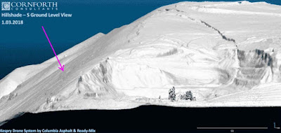
The consultancy that is working fro the rock quarry at the base of the slide has developed three time lidar images of the slide that if looked at carefully show that westward bulging.       

rattlesnake+Ridge+Landslide&source


arrow point to change area of bulging slope, but the overall movement measurements are that the sliding is moving toward the quarry in the foreground


Tuesday, January 16, 2018

Remarkable Images of the Ongoing Rattlesnake Ridge Slide

The Rattlesnake Ridge slope failure adjacent to Union Gap is turning into a well documented slide. The slope movement has continued to progress with the slide moving towards the rock quarry. As the slide has progressed, the fractures have become more developed - particularly the fractures that extend across the slope break and down onto the steep river gap slope.

This drone video is the best I have seen at showing this feature.


The Washington State Department of Transportation has a blog dedicated to the slide and the Washington State Department of Natural Resources has a page describing the slide as well with good figures for describing the feature

https://wsdotblog.blogspot.com/2018/01/crews-monitoring-land-movement-on.html

https://www.dnr.wa.gov/rattlesnake-hills-landslide


Diagram of slide by DNR

A set of pictures of the slide is provided at
https://www.flickr.com/photos/wastatednr/sets/72157692053372215

The documentation of this large translational slide involving basalt lava flows sliding over an old interbed soil has been fascinating to follow. But the way this slide is moving and intersects the slope of the river gap has created a remarkable and unique perspective.

The following two pictures by Tom Ring with the Yakama Nation are -- well incredible. The slope of the river gap intersects the lower failure plain of the slide. As the slide has moved the fractures have traced the base of the failure along the steep sidewall of Union Gap.     

Click the picture to expand and note the dark line angling across the slope that traces the base of the slide that is moving from left to right 

Closer view of the base of the slide area. 

One of the big questions about this slide will be how the edge of the slide shown in the two pictures above will behave as it progresses from left to right. How much will the edge of the slide disaggregate and tumble down the steep essentially angle of repose slope?

The DNR and WDOT recognizes that there is some uncertainty, but overall seem to be taking a proactive and precautionary approach.  

Monday, January 15, 2018

Samish Flats Eagle Tree


 After a very colorful sunrise (alas our sunny break is to end), I paused for a bit by the Eagle Tree. 

I counted 16 bald eagles with 13 in the tree, one perched in a nearby tree and two more inbound.

The tree is a well know favorite for Samish Flats birders. 


The tree is a cottonwood and is ideally located for eagles. There are few tall tress on the Samish Flats as much of the land is agricultural fields or too inundated with water both fresh and salt to support large trees. The perch provides excellent views over the nearby Fish and Wildlife lands, the Samish River and Samish and Alice Bays with Padilla Bay not far away either.


The Samish Flats is a northwest continuation of the large Skagit River delta called the Skagit Flats. The Samish Flats cover an area of the delta not currently occupied by the Skagit.

Friday, January 12, 2018

Fraser Outflow Keeping Bellingham Cool

Our weather reports in western Washington tend to be Seattle-centric. Radio reports this morning indicated expected highs in the upper 40s and low 50s for western Washington. Indeed that is the case in Seattle.


60 miles to the north at Burlington/Mount Vernon it was 48.


But 15 miles further north in Bellingham the temperature was a cool 36.


This is a classic modest Fraser outflow event cooling the local area with cold interior flowing down the Fraser valley. At the mouth of the valley it is 32. Note that the wind direction at Bellingham is from the north. All in all not a particularly pleasant day with cold fog and drizzle. 

Monday, January 8, 2018

A Few Geology Notes on the Rattlesnake Ridge Slide


The landslide at Union Gap has been getting attention:

blogs.agu.org/landslideblog/rattlesnake-ridge

The best coverage is via a series of articles in the Yakima Herald:

yakimaherald.com/what-lies-ahead-as-fissures-continue-to-widen

yakimaherald/slide/watching-waiting-for-rattlesnake-ridge-slide

The slide has been assessed and monitored by a consultancy out of Portland (they were hired by the rock quarry below the failure once the fractures appeared) as well as Washington State Department of Natural Resources, Washington State Department of Transportation and Yakima County. Pacific Seismic Network has installed seismometers.

The initial imagery and media reports did present a bit of a challenge to discern the direction of slide movement, but there is a general agreement that the slide is moving towards the south, towards the large quarry that has been excavated into the slope to the south. This Picture in the Yakima Herald article provides a good perspective and shows the curvature of the head of the slide.

Based on the reported movement direction, aerial images and geology mapping, the slide may have  developed within an old soil horizon between basalt lava flow layers such that it is a dip slope translational failure or the failure could be taking place along a area of fractured bedrock associated with the faulting that has taken place within the ridge. Although basalt is a rather hard rock, basalt lava flows are typically highly jointed and fractured from cooling and/or interaction with water or wet ground. A clip of the local geology map shows the layered basalt units and faulting as well as folding within the Rattlesnake Ridge on the east side of Union Gap.

Clip of the Geologic Map of the east half of the Yakima 1:100,000 Qudrangle (Schuster, 1994)

The map is a bit of a challenge to read. Rattlesnake Ridge is one of several east-west trending ridges in the Yakima Fold Belt. The ridges are generally anticlines, but the folding is tight, and faults are present on these ridges as well.

The layered basalt lava flows with old soil horizons between with subsequent tilting and faulting is a recipe for large scale bedrock landslides. Indeed, the folded and faulted basalt are sites of many very large-scale landslides.

The layering, though faint, can be seen in the image from Steven Mack's video of the slide. The layers of basalt slope towards the quarry that has been excavated into the slope. Hence, the geology as well as the measured slope movement suggests most of the slide will be directed into the quarry.


View of quarry with fractured ground above

Projected movement toward quarry
Homes are located beyond quarry and have been evacuated

An interesting twist to this slide is that the cracked slope extends across the slope break towards the west such that a portion of the failure is located above the very steep slope of the river gap.


In my mind, it is pretty easy to see that as the sliding progresses towards the quarry, the material above the gap will break apart and some material will slide, not toward the quarry but down the steep gap slope. Movement of material down this side slope poses a very distinct threat to the interstate highway at the base of the slope.

Saturday, January 6, 2018

A Stand of Querus garryana (Gary oak) in Skagit County is Lost

Chuckanut Drive (State Highway 11) winds along the mountainous shoreline south of Bellingham. It is a very scenic route with views across Samish bay to the San Juan Islands and Olympic Mountains. There are several pullouts to take in the views. One pullout is just north of a nice outcrop of fossil palm fronds in the Eocene Chuckanut Formation. The slope just below the scenic overlook was until very recently the site of one of the northernmost stands of Querus garryana (Gary oak) in Washington State. However, most of the trees were recently cut down. 


The removal may have been to maintain the view as the trees that were cut have been left on the ground. However, other trees remain and I have yet to have been discover the purpose of the cutting.


Regardless of the purpose, it was disappointing to loose a stand of trees that were growing at the fringe of their range. The map below from Wiki is a fairly accurate portrayal of the range of this oak.

Quercus garryana range map 1.png

There are stands to the north along the warm/dry side of lower Vancouver Island and a couple of isolated patches in the Fraser Valley. Those Canadian stands are considered one of the rarest ecosystems in Canada, and there has been significant effort to protect the oak habitat in Canada for that reason. In Washington State, Pierce County and Thurston County have some ecosystem protection for oak. There was a case in Pierce County where a developer had their permits revoked after violating the conditions on the permit that protected oaks on the site.

In Washington State, the map just shows where the trees may be found. Around the Salish Sea/Puget Sound most of the oaks are pretty patchy and are only found is isolated stands. Areas where oaks are common are only in the southern part of the state and oak forest stands are present in areas of the Columbia Gorge and a few east of the Cascade Mountains in areas where the local climate transitions from wet to dry. 

Wednesday, January 3, 2018

High Quality Video of Fracture Development at Union Gap Slope Failure

A so far slow moving slope failure has developed just south of Yakima where the Yakima River cuts through Rattlesnake Ridge at Union Gap. I have had numerous emails and linked facebook posts sent my way on this.

yakimaherald.coml/majority-hold-off-on-call-to-evacuate-near-rattlesnake-ridge


This failure is a worrisome event. The orientation and geometry of the fractures suggests that the movement is towards the steep slope of the gap; however, news articles suggest that mush of the slide will be directed towards the quarry. The cracks have formed a graben-like feature. One of the articles by the Yakima Herald noted rock fall onto Thorpe Road. That suggests some deformation may be taking place on the slope below the fractures and on the steep slope.

Maybe a bit more on this later. Travel and now work precludes much time to get into more detailed theory or research or information sharing.