Tuesday, November 27, 2018

Technical Brush Climbing

Today involved some technical climbing in brush. Our first two attempts to descend a steep bluff were cut off by a vertical drop above the beach. Our third attempt was down through a more recent landslide. The footing was bad due to rooting logs crisscrossed on the ground, the steepness of the slope and slippery soils. The bigger challenge was the thicket of thimble berry with trailing blackberry. 

Geoff working his way back up the slope.
A thick sweat shirt with hood is not a bad gear choice

Geoff making the key crux move

The big plus was the unexpectedly nice weather - sun and 60 degrees in late November was not expected. Much better than the day before with several daily rainfall records broken in the area.

View across Oak Bay to the southern end of Marrowstone Island

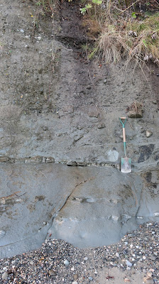
Making it to the shore allowed us to assess the lower bluff.

Quimper Sandstone overlain by glacial till
The contact is just above the shovel handle 

Concretions in Quimper Sandstone

Sunday, November 25, 2018

Ice Age Boulders in Drayton Harbor

Drayton Harbor is a shallow bay just south of the Canadian border. The City of Blaine is located on its northeast and southwest sides such that the small city has two parts separated by the bay. 

The predominant geology formation around the bay is glacial marine drift. During the last glacial period, glacial ice in this area was on the order of 6,000 feet thick. That mass of ice load pushed the local land surface downward hundreds of feet. During the late stages of the glacial period, the ice thinned and the area was inundated with sea water with ice floating on the surface. As the floating ice melted, sediment would drop out of the ice and land on the seafloor below. The sediment included boulders. Post ice age the land surface rebounded and lifted the former sea floor above sea level. 

Along the south tidal area of Drayton Harbor, boulders that had been dropped out of that ice sheet are scattered across the otherwise muddy tidal flats.    

Drayton Harbor with three glacial erratic boulders 

The tide was high when I stopped at the shore, so many of the tidal boulders were covered. Just about every time I pass by this shore, a great blue heron is using one of the rocks as a resting perch.


Friday, November 23, 2018

Eastern Washington Ice Fog and Riparian Forest on the Columbia

Much of eastern Washington is dry. Total precipitation is as low as 6 to 7 inches in the driest parts. However, winter is not necessarily sunny in these dry areas. The bowl-like shape of the Columbia Basin traps cold air that tends to stagnate as a blanket of chilly fog. The result can be days no sun.

Over the past week the fog was spotty as I meandered about on my various ventures. The temperatures were cold enough to brighten the landscape with the fog freezing on the plants.

No distant views on this stretch of the trip

Flocked trees at Verneta

The Columbia River is warm compared to the air and adds to the fog near Priest Rapids

The fog thinned near Mattawa and the orchard/vineyard windbreak trees provided a nice winter show 

The fog was limited to the lower Columbia Basin on this day and I broke free of the fog at Sentinel Gap 

Much warmer and bright north of the gap at a familiar line of trees along the river downstream of the old rail bridge. I wrote a report on this tree stand a while back. The evergreens are junipers. They as well as the other river front trees have become progressively thicker since. The tree stand is not "natural", but is the result of alteration of the flow regime on the river. The big yearly floods of the past are no more and hence the riparian areas are not as dynamic as there were in the past allowing trees to become established along the river side. The development of these riparian forest zones has created new ecosystems along the Columbia River.

Thursday, November 22, 2018

Silica Road

Interstate 90 crosses the Columbia River at Vantage. Heading east the highway climbs up out of the deep river valley to the tops of the basalt cliffs and skirts the northwest end of the Frenchman Hills and enters the Quincy Basin.

Silica Road is a familiar exit for Gorge concert goers. The concert venue is located at an ice age spill way where flood water from ice age floods spilled out of the Quincy Basin into the Columbia River gorge. 


Silica road passes through an area of surface mining. The mines mine silica from old lake beds that formed between lava flows of the Columbia River Basalts.

White area on horizon is one of the mines

The silica is diatomaceous material. That is the silica is the accumulation of diatom shells on the lake beds. The lakes must have received very little sediment and thus the diatoms were the primary sediment accumulation in the lake bed. Diatomaceous material has lots of uses from high quality water filters to natural pesticides (the rough mirco glass structure of the silica is hard on bugs).

The ongoing mine activity is located both south and north of the Interstate.

Mines north of Interstate 90. Silica Road passes through this area on the way to the Gorge.

Mines south of Interstate 90.

The mine reclamation requirements are overseen by the Washington State Department of Natural Resources. The mines to the south of the Interstate are in areas with preexisting soil cover and have been reclaimed back to agricultural use. I recall one mine received an award for the reclamation work completed. 

Monday, November 19, 2018

Over the Soon to Close North Cascade Highway

Given the late date, it was nice to be able to cross the Cascades Range via Washington Pass and Rainy Pass on the North Cascades Highway. It is a rather quiet route this time of year.

 Other than a skiff of snow on Washington Pass, there was no snow on the road. However, cold air flowing down Granite Creek and Ruby Creek had caused a bit of thin ice covering for about 15 miles, but also provided lovely flocked trees along the valley bottoms.


Coming storm systems should quickly close the road for the season. Probably would not be an advisable route for Turkey Day travelers. 

Saturday, November 17, 2018

Cobble Depressions in Sand

After some field ventures through brush and ravines, the best way back to the car was via a forest road versus back tracking through the brushy route I had descended. The upper forest road I hiked in on was across sitltstone and sandstone and the weathered rock was impressively slippery. The lower road was across alpine glacial outwash dominated by sand, cobbles and boulders and was easy walking and only a bit further.  

I was cognizant of deer, elk and cougar tacks on the road so I was paying attention to the road surface. I also thought it best not to run given the presence cougars and did occasionally look behind me to be sure no confused cougars thought mean easy mark.  

The depressions on the surface of this road section were not from animals, but were from rocks that had sunk into road surface.


The ground had been frozen earlier in the day. My take on this phenomenon was that the water around the sand with some silt caused the surface layer of sand to expand while the larger rocks took longer to freeze and likely did not freeze at all. The sandy soil expanded upward, leaving the cobbles in depressions. The sand around the cobbles was soft and non compact from the freezing expansion. Deeper freezes can cause the reverse and push stones up above the surface. The weather the night before was in the low 20s but had been 50s during the day.

Seeing the dynamic surface soils process was a good reminder of foundation depths for frost protection. Probably would want a deeper footing depth in this chilly east slope of the Cascades valley.   

Wednesday, November 7, 2018

A November Sighting of Vanessa atalanta on Orcas Island

Vanessa atalanta (red admiral) is one of the most widespread butterflies in the world. I do not spot them very often and my first inclination when this one caught my eye was it was a Limenitis lorquini lorquini (Lorquin's admiral), a butterfly I frequently see (lorquins-admiral). But in this case the markings were obviously wrong.   


This one was sunning itself on a south facing bedrock cliff of the Constitution Formation on Orcas Island. I was enjoying the sun and the south facing rock myself while waiting for a ferry to Lopez. I took care not to disturb the butterfly. Sun on a November day had not been expected nor was seeing a butterfly this late in the year.

The week before I noted a patch of young nettles on Orcas Island - the food source for Vanessa atalanta pupae. I was a bit surprised to see young nettles in the forest in the fall - more typically they are a early spring plant. Perhaps the mild San Juan winters provide a niche habitat for this butterfly. 


Tuesday, November 6, 2018

Visit to the Lopez Structural Complex at Richardson

The end of the road at Richardson on the southern shore of Lopez Island provides an easy to access view of part of the Lopez Structural Complex. 

Richardson is named for the original land patent holder. He was granted the land shortly after the San Juan Island was determined to be part of the United States after a couple of decades of dispute between Great Britain and the United States regarding claims to the islands. 

The community of Richardson grew as a commercial and fishing center in the late 1800s through the early 1900s. It was well positioned as a protected deep water port for transporting farm products off the island and bringing goods to the island. A cannery for the fishing industry was located at the bay shore to process salmon that were netted via net traps set along the south shore of the island. Over time agricultural changes, fishing changes and the location of the ferry on the north side of the island led to the commercial development fading away. For a time a store at the end of the road was a destination for visitors - I once ate a large ice cream cone after a bike ride to the south end of the island. The abandoned dock and bulk fuel facility remain, but the store is gone. 

Former bulk fuel storage tanks

Old dock with Olympic Range in the distance across the Strait of Juan de Fuca.

The road end at the old bulk fuel facility provides easy access to views of a portion of the Lopez Structural Complex (LSC). This location is discussed in Brandon (1989)Brown and others (2005) and Brown, Housen and Schermer (2007). Relative to other parts of the LSC this area appears somewhat coherent; however, this site has some highly deformed and fault bound units as well.

Just below the end of the road along the shore are great exposures of pillow basalt.

Pillow basalt. Note sheared zone at base of pillows in picture


This basalt is an ocean floor basalt. The pillow structures are hardly disturbed at all despite having been once deep within a subduction zone trench more than 20 kms below the surface.

A short distance away the pillows are deformed.

Stretched and deformed pillows

At the road cut above the shore a contact between greenish metamorphosed volcanic rocks and maroon mudstones is a good example of why the Lopez Structural Complex is called a complex.


Analysis of micro fossils in the mudstone suggest an age of 112-115 Ma (million years) (Brown and others, 2005). The mudstone and the contacts along the mudstone appear to be highly sheared.


Shearing within the LSC often appears to be more intense as tectonic stress and fault movement may preferentially take place within weaker rock units. Brown and others (2005) also dated metamorphic minerals in the pillow basalt and found metamorphism of the basalt took place at 124 Ma. Hence, the pillow basalt is older and was deep in the subduction trench when the mudstone was formed. The mudstone was not deposited on the basalt, but the two units were faulted so that they are now abutted with one another.

This finding has implications for trying to piece together the assemblage of accreted terranes that make up northwest Washington - a very tough puzzle that has led to very different interpretations.

The complexity of the LSC and the context of the LSC within the accreted terranes of northwest Washington and western North America is a lot to take in. Besides getting a little perspective of tectonic geology it is simply nice to see well exposed bedrock and structures in western Washington.

I liked this small exposure as it captures an observation Brandon made about trying to decipher tectonic deformation from soft sediment deformation.

Behind the mail box it is clear these rocks have undergone multiple deformation events.


Tight small fold adjacent to shear surface


Pillow basalt being made unrecognizable

Highly sheared volcanic breccia