Showing posts with label geology. Show all posts

Friday, March 20, 2026

I 5 Rock Slide South of Bellingham Covered by Cascadia Weekly

Annie Todd at Cascadiadaily did a write up on the landslide that blocked the north bound lanes of Interstate 5 south of Bellingham. The article includes a very good picture of the slide via a drone shot image by Finn Wendt. Annie alerted me to the slide via email and wanted to know if I had any info; hence, some quotes in the article. 

I have not done any work on this slide, but I am familiar with the site having driven past it many times. I did a quick look at the DOT site and was fairly sure of the site.  


My very first vist to Bellingham before living there I had to drive around a car sized boulder that had come off the road cut very near where this recent failure took place. The road cut for the interstate is into Chuckanut Formation. The bedrock layers are dipping into the slope, but joints within the sandstone are very susceptible to failures and this cut slope has a long history of rocks breaking off of the slope along the large joint sets. The Department of Transportation cut this slope back substatially in the past and created a slide/rockfall collection zone at the base of the slope and installed bolts on portions of the slope to reduce the scale of the failures. In the image of the article, it appears that most, if not all the rock was contained within the area outside the travel lanes, but the trees on top of the failures extened out into the travel lanes. Given the size of the bedrock blocks, removal and clearing will be a bit tricky from a safety perspective.

On a final note, I greatly appreciate Cascadia Weekly. Local news coverage is critical and they do a good job for the northwest corner of Washington. 

Wednesday, November 26, 2025

Blue River and Rare Earths in British Columbia

Flying back to home I recognized the small British Columbia town of Blue River through a break in the clouds. 

Blue River (town) and Mud Lake

I recognized this location because of some recent literature research I was doing on carbonatites combined with a bit of Google Earth viewing to find the locations of carbonatite claims so I could do some comparative geology. I had looked careful at this area and read numerous reports on the carbonatites found in the area so easily recognized the lake and town through the break in the clouds. Carbonatites are igneous rocks containing predominantly carbonate minerals. Carbonatites have been a focus of exploration in British Columbia and there have been several claims with associated exploration sampling in the Blue River area. The carbonatites occur within an area of alkaline igneous rocks that intrude the Paleozoic strata west of the Rocky Mountains in the eastern part of the Omineca Belt.

The interest in these rocks is that carbonatites can be enriched with rare earth elements. A hot topic in geopolitics. With a long and ongoing mining history as well as mineral processing, BC may be well positioned to exploit these resources if it proves feasible. The thick forest and rugged terrain do present a challenge relative to the well exposed deposits in China. China also has had the advantage of a longer period of figuring out processing the ores - an underappreciated aspect of the minerals industry. 

The Canadian federal government has been supporting some of the exploration as well as mineral processing.  

https://www.canada.ca/en/campaign/critical-minerals-in-canada/federal-support-for-critical-mineral-projects-and-value-chains/critical-minerals-geoscience-and-data-initiative.html

Sunday, May 18, 2025

Rocky Mountain Trench Rivers

On my way home I had a nice view of the Rocky Mountain Trench.

Rocky Mountain Trench looking towards the north. 
The north arm of Kinbasket Lake is in the trench on the right.
The valley west of the trench is the upper Thompson River.

The Trench is a remakable feature that is about 1,000 miles long. The feature jumps out in satelite imagery and Google Earth as the lower elevation of the trench forms a dark swath through the high snow covered mountains of the BC interior. The trench follows a major strike-slip tectonic fault, the Tintina Fault. There are other trench like feautes that are somewhat parallel, but none are as continuous. A number of major western rivers flow into and out of the trench. The river plumbing is complex and intriguing.

A few of the Trench rivers: Fraser, Canoe, Columbia and Kootenay. 

The source of the Columbia River is within the trench south of the photograph I took. Kinbasket Lake was formed in the Trench when Mica Dam was built across the location where the Columbia leaves the Trench. The north arm of Kinbasket Lake in the picure is the now flooded Canoe River. Not far north of the lake and Canoe River the Fraser River flows into the Trench and follows the Trench to the north for a long distance. Like the Columbia, the Fraser leaves the Trench and makes a U turn and heads south. I also marked the Kootenay River on the Google Erath view. The Kootenay flows into the trench from the east about 1 mile south of the Columbia source at Canal Flats, but the Kootenay heads south down the Trench whereas the Columbia flows north. Eventually the Kootenay exits the Trench and joins the Columbia.        

It is intriguing to think about how the ice ages may have rearranged the upper river systems. If we look at the current river routes, one can imagine glacial ice filling the northern portion of the Trench and forcing the upper Fraser south into the Columbia. Or the Columbia being blocked by ice and flowing south down what is now the Kootenay route. I can also imagine that prior to the last glacial period the upper river routes may have differed possibly resulting in an even larger Columbia or alternatively a larger Fraser.  

Thursday, May 1, 2025

Returning Home with a 'View' of the BC Coast Range

 Returning home the southern portion of the BC Coast Range was obscured by low clouds; hence, I was unable to observe some of the challenging areas from past geology ventures of another work era as the plane descended towards Vancouver. One peak poked above the cloud cover.


The cloud cover was not a bad mimic of the past when the BC Coast Range was mantled with a massive ice sheet that flowed down into the lowlands into the northern Washington straits and out the Strait of Juan de Fuca and filling the Puget lowland with ice all the way to south of Olympia.

Saturday, February 15, 2025

1950 Jackson Creek, Skagit County Debris Flow

The Highway 9 corridor from Sedro-Wooley to Kendal follows the Samish River Valley and then after crossing a very subtle divide follows the South Fork Nooksack River Valley. I previously noted the alluvial fans associated with steams that flow into the Sanish River Valley (alluvial-fans-altering-samish-river).

Doing some review of the valley I came across this 1950 aerial of Jackson Creek with a recent debris flow scar path and deposit on the alluvial fan that extends out onto the Samish Valley floor.  

Jackman Creek 1950 with debris flow scar and debris flow deposit

Timber harvests have started up again in the Jackson Creek watershed, but the creek and the steep slopes near the creek have been partially buffered versus the previous log everything approach. The other substantive change is road construction across stream subject to debris flows have generally improved to reduce the risk of the road causing a debris flow. That said the creek is lined with steep unstable slopes and future slope failures and accumulation of debris  

Jackson Creek (2023, Skagit County) 

The Jackson Creek alluvial fan has resulted in a lake upstream from the fan and there is a lake down stream that is influenced by another alluvial fan at Mill Creek. Both of these lakes may also be influenced by beaver activity. Mill Creek had a debris flow in 1983 that resulted in a fatality.  

Lidar bare earth (via Skagit County)

It appears that a fairly large berm was built post the debris flow. There is a gap in the berm where a natural gas pipline was constructed. The dredge spoils are on the distill end of the fan and this spot may need periodic dredging to keep the creek passing under the railroad.

Sunday, January 26, 2025

Highway 397 Road Cut West of Nine Mile Canyon, Part I

 
Highway 397 is a spur highway off of Interstate 84 south of Kennewick that accesses the Finley area to the east of Kennewick. The route by-passes Kennewick, angling across the northern slopes of the Horse Heaven Hills south of Kennewick. A road cut just west of South Nine Canyon Road (46.07'47", 119.04'38") got my attention with a variety of geology units. This post is Part I and is focused on the west end of the cut slope where a sedimentary unit is exposed between Columbia River Basalt Group lava flows.

West end of the cut slope

Lake sediments from between lava flows. The sediment appears tuffaceous.

A mix of basalt rubble and sediment

Basalt rubble within sediment with some very 'cooked' sediment

Sediment at base of lava flow

Closer view of sediment at base of lava flow

Reidel and Fecht (1994) geology map covers this area at a 1:100,000 scale. The scale precludes some detail and the sediment interbeds are not shown. Furthermore the road cut post dates the geology mapping of the area. They note that these interbeds of sediment are generally best exposed in road cuts. Where the interbeds are mapped they are referred to as continental sedimentary deposits. In places where gravel is present, the gravel appears to be sourced from ancestral Columbia River or Salmon/Clearwater River flow paths as the grvael contains rocks with a continental affinity.

The map does indicate that the lower basalt below the sediment is the Umatilla Member and the upper basalt is the Pamona Member. Both of these members are part of the Saddle Mountains Formation of the Columbia River Basalt Group. 

The delineation of these basalt flows was accomplished via a combination of geochemistry, magnetic polarity and isotopic ages.  


The lava flows in the chart above between the Umatilla and Pamona are generally more localized lava flows or smaller flows restricted to ancestral river valleys. The lack of flows between the Umatilla and Pamona as well as the thinness of Continental deposits at this site suggests this site was elevated relative to the broader Columbia Basin similar to today.


Tuesday, November 12, 2024

Volcanic Ash at Palmer Lake

 A road cut along the southeast side of Palmer Lake consists primarily of angular rocks, but a thick white layer is located below the uppermost layer of angular rocks. The white layer is volcanic ash. 

Layer of volcanic ash withg talus and scree below and above the ash layer


The ash is very fine powder

I am not sure of the source. There are reported ash depsits to the south near Chelan and the soils of the Waterville Plateau that have been connected to Glacier Peak. I have observed that ash and it is generally coarser. I suspect this is Mazama ash from the massive Mount Mazama (Crater Lake) eruption There is widespread ash depsoits from Mazama throughout eastern and central Washington. Because layers of volcanic ash are common in the Pacific Northwest, they serve as extremely good stratigraphic markers when applied to geologic and archaeologic problems, as long as they are correctly identified and correlated. The ash is a time marker for the deposition of the talus and scree exposed on the cut slope.   

View of Palmer Lake from the north end of the lake.
The ash exposure is at the base of the cliffy areas in the central distance.

Thursday, July 4, 2024

Chandler Narrows I

On my way to another venture I observed this road cut west of Benton City in the lower, eastern Yakima valley.


The location is mapped as an ice age flood deposit by Reidel and Fecht (1994). My interpretation of the road cut exposure is that both the lower silt and the upper gravel were deposited during a ice age flood events.

The silt would have been deposited when the site was temporarily inundated by the short lived Lake Lewis.

Map of Lake Lewis with water level at 305 meters.
White arrows show flow path of ice age flood waters into the lake from left to right: Columbia River, Drumheller Channel, Washtucna Coulee, and spill over into the Snake River.

Lake Lewis formed due to the restriction at the narrow gap at Wallula Gap through the Horse Heaven Hills. The backing up of water resulted in deposition of silt in the queit water areas of the temporary lake including extensive silt deposits around the area of Benton City and up in the Yakima Valley.

As the lake drained down, water that had filled the Yakima Valley had to pass through a relatively narrow exit at Chandler Narrows.


The relatively narrow lower Yakima Valley resulted in high flow velocity of the water as it drained out of the valley. The result was an area of classic eastern Washington scab land in the eroded basalt up stream of the gravel deposit.

Basalt cliffs with latge basalt blocks ripped off the cliffs along the 
Chandler narrows reach of the Yakima Valley

Patch of grapes in the scab land landscape
This are is a hot wine area just west of Red Mountain

Thick gravel deposits just belwo the Chandler Narrows

Thursday, May 23, 2024

A Stop at Agate Fossil Beds National Monument

When I lived in Colorado I ventured north from Colorado during a 5-day weekend with a scheme of visiting some of the places my father and grandmother told me about from a past family venture they had with my grandfather. One side adventure I wanted to make was a stop at Agate Fossil Beds National Monument (https://www.nps.gov/agfo/index.htm) in the Nebraska panhandle. 

My scheme of visiting the Monument got sidetracked. At a county road intersection well south of the Monument I saw someone pop up out of the grass by the side of the road waving a bit frantically. I stopped. The person I saw had fallen aslseep waiting for the rare car that passed by. He needed a ride to a town past the Monument. Given the lack of vehicles, I opted to pass by my planned turn off and took him into town. We went into the cafe where he bought me a burger and beer on the family tab and called home for a final lift. It was a well worthwhile 'good deed' that was a nice part of the trip. However, I did miss the trip to Agate.  

A fair bit of time has passed since that venture, but I always hoped to get another chance to see the Agate Fossil Beds Monument. Recently I had another chance. 

Heading west across the high plains of western Nebraska 

I did have some good luck in that the blizzard that had blown through the area a couple days before had not blocked my route. And the cattle were courteous and politely curious. 


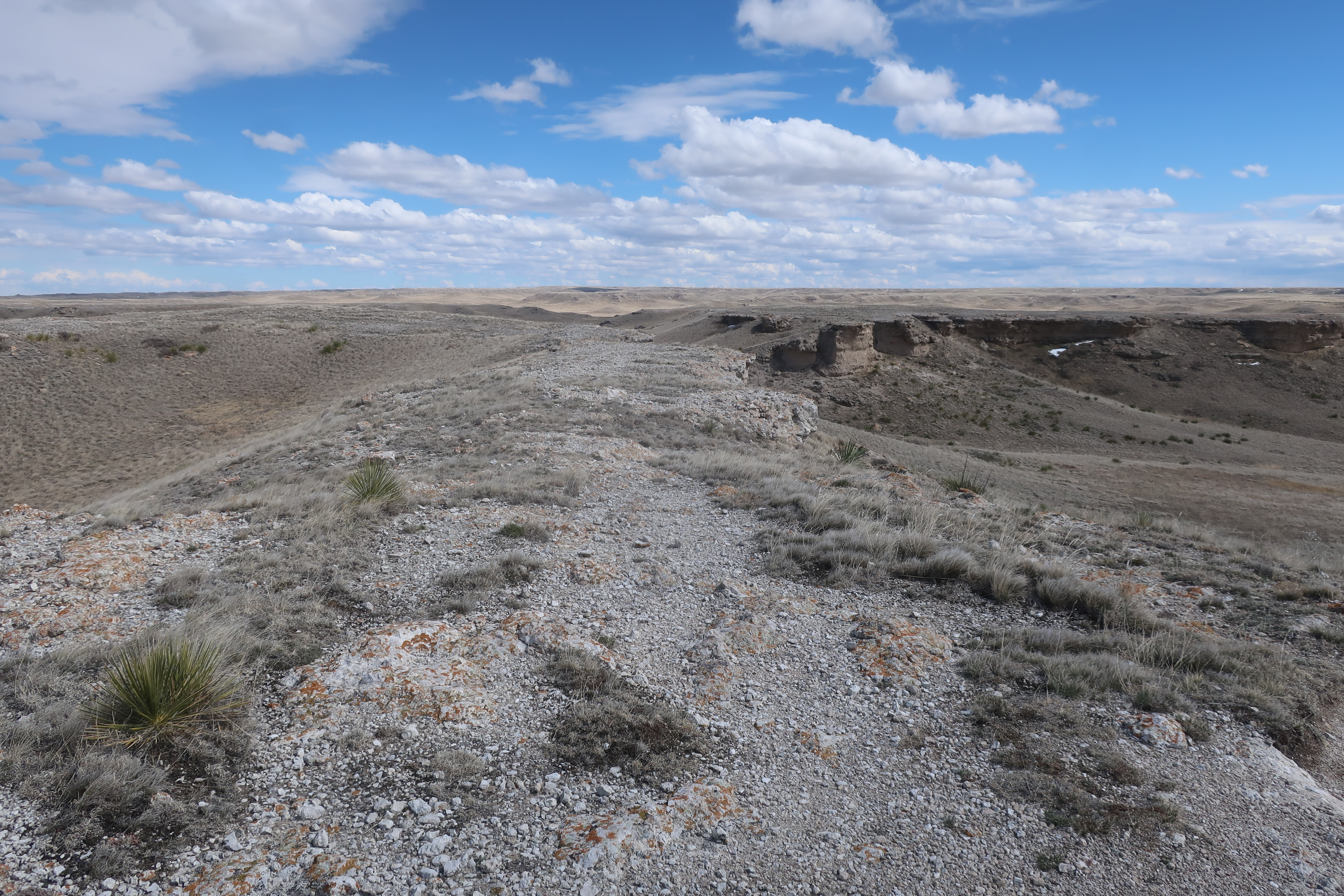
The Monument landscape is high plains dissected by a river valley and associated small tributary streams that expose the Miocene age soft sediments protected by a cap of silcrete and limestone lake deposits. 

Silcrete and limestone cap above the Miocene sediments.

The fossils were found in fairly soft Miocene sediments. The fame of the site was the discovery of a bone yard of fossil bones in the late 1800s. That pile of bones has been interpreted to have been a watering hole with the idea of many animals dying at the watering hole during a bad drought. Subsequent fossil bone finds in the Monument have added to our understanding of life on the plains 22 million years ago. 

I took a hike through a small area of the Monument. No big bones exposed, but there are plenty of fossils. 

Miocene soil horizon just below the cap rock

Worm burrow casts and root casts in the soil 

Careful study of these soil horizons and small fossils tell a great deal about the setting. There is one burrow cast preserved on the trail that took a few years to figure out. 

Paleocastor burrow protected from erosion by a plexiglass box
Paleocastor was a dry land beaver

A collection of some of assembled skeletons from the fossils are on display at the visitor center. I am not a paleontologist. When I taught the paleo lab class I was a half a day ahead of the students at best. I have a deep appreciation of the field and the workers extracting information out of the fossils and the soils and rock the fossils are found in and passing that deep history to casual visitors to museums and in this case a National Monument.

There is another aspect of Agate Fossil Beds that was a delight and links back to my father and grandmothers stories from their travels. They visited the Red Cloud Agency on the Pine Ridge Reservation. That visit left a lasting impression that was passed down to me through their stories. Red Cloud was a friend of James Cook, the rancher that ranched in what is now the Monument.The friendship and exchanges between Cook and Red Cloud resulted in a family collection that the Cooks later gave to the park and are on display at the visitor center. 

Red Cloud's people had left a lasting impression on my family. Seeing the display and picture of Red Cloud and the display of Lakota culture solidified that family impression and the connection to Pine Ridge and the complex and at times tragic history of the area.     


Photograph of Red Cloud's bedroom


Sunday, April 28, 2024

Notes on the Permian Basin

I recently had some ventures in the Permian Basin. The Permian Basin looms large in geology lore and American/global policy. The basin extends from southeast New Mexico trough a wide swath of western Texas. The sediments that were deposited in the basin span much of the Cambrian and were capped by a massive carbonate reef building period during the Permian, The long geologic history recorded in the basin rocks and the massive reef building is a subject in many geology text books in a large part because the Permian Basin has garnered a lot of geologic attention - it is the largest oil producing basin in the United States. Hence, the basin subsurface geology has been well explored and there are very good exposures of the basin rocks along the steep slopes of the Guadalupe Mountains on the western edge of the basin where uplift along a steep set of faults provides good cross sectional views of the Capitan Reef.

View of the El Capitan, the Permian Basin and west Texas from Guadalupe Peak  

The trail up to the summit of Guadalupe Peak is about a 2,750-foot rocky trail with lots of big steps. It draws an eclectic crowd as it is the highest point in Texas and the hike is hard enough that anyone completing it should feel good about their accomplishment. 

I was a bit time constrained starting at around 2 in the afternoon so I really did not have a lot of time to inspect the geology in detail, but did pause on occasion to inspect fossils and noted how much I have forgotten about them and the Permian Capitan Reef. 

The oil and gas production in the basin is going through boom period with directional drilling and hydraulic fracturing reinvigorating old fields and opening up new fields. The attractive prices for oil is playing a significant role and investment must be assuming that the price for oil will be worth the expansion in production capacity. 

The evidence of the boom is readily apparent out in the high dry plains above the basin sediments.

Drill tower in northwest Texas

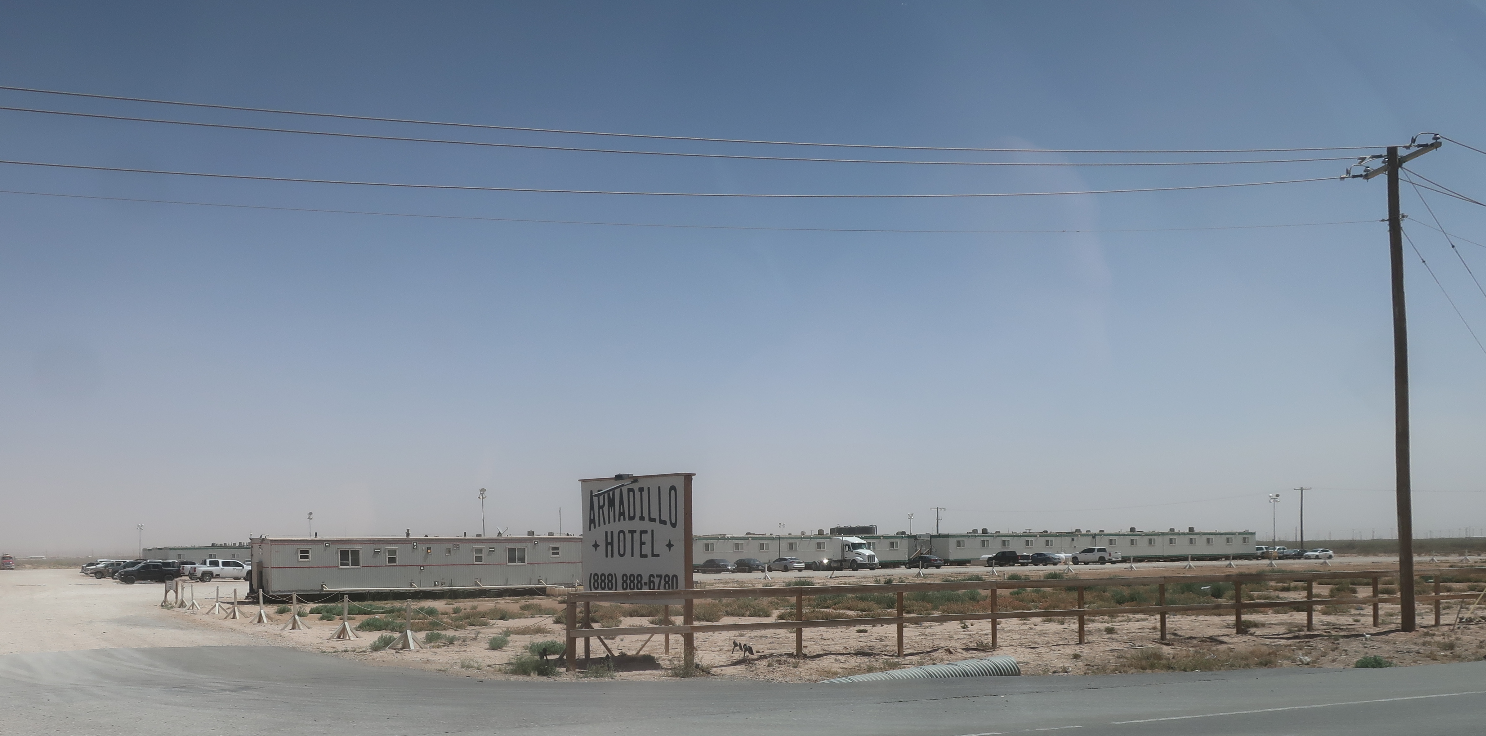
I was struck by the response to housing needs in the fields. Perhaps the same logistics regarding housing could be applied elsewhere.

Portable apartment housing for workers in the oil fields

Canopies for shade for workers with campers

Portable hotel

I did not stay at any of the above but did stay at a smaller portable motel. Comfortable bed, a good shower, desk, refrigerator and microwave made for all I needed.

There is subject of some policy debate. The rapid expansion of oil production also produces a lot of methane. While oil is profitable, the natural gas prices are low and therefore flaring, burning off the gas, has increased.

The natural gas production is exceeding the pipeline capacity and some oil producers are opting to flare the gas instead of delaying oil production. This same scenario took place in the ramping up of the Bakken oil 15 years ago. The financial incentives of resource extraction do not always align with limiting wasting resources.    

There has been an effort to track the methane emissions (PermianMAPFinalReport.pdf). If you do dig into the details it is interesting to see the range of limiting methane emissions by various companies is broad. Most of the big oil companies do better than the smaller operations, but there is an exception. It is a complex issue scientificamerican.com/MethaneLeak.

The National Park Service does have a nice overview of the Permian Basin geology: nps.gov/GuadalupeountainsGeology.

Saturday, February 24, 2024

Sunny Day Above Wallula Gap


DEM showing ice age flood lake that formed above Wallula Gap and above the Columbia River Gorge

I got a chance to get up on the edge of Wallula Gap. Alas access is very limited due to private property. The expansion of big ag ownership with irrigation has resulted access limitations. 

Dry land winter wheat near the west edge of the gap. 
Note that the field was not plowed prior to planting.
This planting method is used in some areas of the eastern Washington dry land wheat belt and has become much more common in the Horse Heaven Hills.

Looking north 

View across the gap looking east. The Oregon-Washington Border heads east from the gap approximately at the middle of the picture.

I have put up a fair number posts on Wallula Gap: 

https://washingtonlandscape.blogspot.com/2014/06/ice-age-floods-dem-and-lake-lewis.html   https://washingtonlandscape.blogspot.com/2011/04/wallula-gap-and-john-mix-stanley.html   https://washingtonlandscape.blogspot.com/2011/04/wallula-gap-and-prime-farmland.html   https://washingtonlandscape.blogspot.com/2012/05/sheep-in-vineyard.html   https://washingtonlandscape.blogspot.com/2012/12/columbia-river-treaty-and-cover-photo.html   https://washingtonlandscape.blogspot.com/2013/01/grand-canyon-and-wallula-gap-its.html   https://washingtonlandscape.blogspot.com/2013/10/wallula-gap-geology-and-art.html   https://washingtonlandscape.blogspot.com/2013/11/lake-lewis-and-wallula-gap.html   

Thursday, January 25, 2024

A Few Notes on Israel Russell

Over the past several months I have encountered Israel Russell on several occasions. Russell did some of the earliest work on trying to figure out some of the remarkable features of Washington State (Russell (1893)Russell (1897) and Russell (1900). He made a significant effort in his writing style to appeal to non geologist readers as well as the technical detail needed for his USGS reports. Russell is referenced several times in a book I recently read, The Great Columbia Plain A Historical Geography 1805-1910 by Donald Meinig. I crossed paths with Russel again when doing some research for work I was doing in the Yakima Canyon. 

1892 View of Yakima Canyon from Russell (1893)
The view is to the north with Rattlesnake Ridge on the distant right side (there is a trail up that ridge).
The railroad grade is on the west, left, side of the river. 
The picture predates the road that was later built on the east side.

I think the picture in the Russell (1893) report was taken from the basalt outcrop below the top edge of the canyon to the left of the tall pine.  
   
Russel (1893) also described the Toppenish Landslide (toppenish-ridge-landslide-near-mabton) as well as the Great Terrace along the Columbia River near Chelan. 

Skye Cooley provides an overview of Russell's 1893 paper on central Washington (i-s-russell-s-reconnaissance-of-central-washington-1893). Note that Skye Cooley also has some great stuff on calcrete in eastern Washington and a really detailed post on clastic dikes in eastern Washington that I find to be consistent with my own observations. Nick Zentner Ice Age Floods Episode D discusses Russell with Skye Cooley. 

And just a week ago In the Company of Plants and Rocks discussed another venture of Russell at Mono Craters (visiting-mono-craters-with-israel-russell). Russell also studied the Malaspina Glacier in Alaska - work that greatly informed his observations along the former ice margins in central Washington including glacial water stream channels south of Lake Chelan in Knapp Coulee. I use images of the Malaspina Glacier as a analog for the past glacial ice in northwest Washington.    

Bretz (1910) described large glacial lakes that formed in the Puget Sound area when glacial ice advanced into the western Washington lowlands from British Columbia stated that "It seems fitting that to this lake of Puget Sound, with outlet southward through Black Lake channel and with levels controlled by that channel, a name should be given in tribute to the work of a geologist to whom our knowledge of the physiography of western North America must always be deeply indebted. In memory of Israel Cook Russell may this water body be known as Lake Russell."

Thursday, December 28, 2023

Haystack Rock and Invasive Columbia River Basalt Group

Haystack Rock at Cannon Beach is one of the iconic images of Oregon. Cannon Beach has a very broad sandy beach both north and south and between the town and the rock. The site is a popular destination and is only about 80 miles from Portland. 


Haystack Rock consists of basalt that is more resistant than the generally very soft marine sediments that make up much of the coast in this area. The basalt is Columbia River Basalt Group magma that erupted as huge flood basalts in northeast Oregon and southeast Washington. The lava flows extended down the ancestral route of the Columbia River all the way to the Pacific Ocean about 15 million years ago. 

The basalts along the Oregon Coast were thought to be of local derivation as there are numerous intrusive dikes and sills within the local sedimentary rocks. However, as detailed chemical analysis and age dates of the basalts were obtained it turned out that these north Oregon coast basalt matched the chemistry and the age of the basalt of the Columbia River Basalt Group. This presented a challenging problem: How could the upper mantle produce virtually identical sequences of magma in these widely separated and tectonically dissimilar regions and yield them for eruption at the same time?  

Beeson, Perttu and Perttu (1979) proposed that the Oregon Coast basalts were the results of lava flows that flowed into the soft sediment along the coast as invasive lava flows that sank down through the muds and sands of the soft sediments. Hence, the dikes and sills of basalt within the soft sediments along north coast of Oregon are not from local volcanic centers but are from lava flows that sank down into the soft sediment intruding or invading the soft sediment mud. 

The haystack rocks and cliff south of Cannon Beach are good sites for observing this phenomenon.


A challenge is to get to the area at low tide. Given that my trips to Cannon Beach have been in the winter when daytime tides were high and coincided with large storms, my observation time was limited or restricted entirely. 

Not much of beach with waves reaching the base of the bluffs.