Tuesday, October 28, 2014

Should I leave the LiDAR 14%?

LiDAR News Magazine makes a case for my discontinuing the use of the term LiDAR: http://www.lidarnews.com/PDF/LiDARNewsMagazine_DeeringStoker-CasingOfLiDAR_Vol4No6.pdf. Of I am apparently in the 14% that have been using LiDAR (light detection and ranging). 65% use the term lidar. My use of LiDAR is consistent with what I perceived as the most common usage. Apparently my perception was off. Of course it might help if LiDAR News Magazine changes their name. 

Sunday, October 26, 2014

Orcas Island Tectonic Zone on East Sound

Mount Constitution and East Sound on Orcas Island 

East Sound and fishing boat

East Sound is a fjord on the south side of Orcas Island. It consists of a deep bay with Mount Constitution rising to over 2,400 feet to the east as well as other steep slopes and cliffs much of it on private land. The small town of Eastsound (note the spelling) is located at the north, upper end of the inlet.
 
Several major tectonic thrust fault zone structures cut across the Sound and are exposed along the shoreline rocks. These faults juxtapose a wide variety of accreted terranes. Near the upper end of the Sound is a tectonic zone where Jurassic to Tiassic Orcas Chert, Triassic to Permian Deadman Bay Volcanics and pre-Devonian Turtleback Complex are interleaved and mixed up within a tectonic zone and so mangled to be often indistinguishable. Thinking through where these terranes originated and how they ended up here requires a broad understanding of global plate tectonics over deep geologic time as well as correlating slivers of rocks spread out over huge distances by plate tectonics all done while pulling out chemical and mineral data the rocks involved. Brown, Housen and Schermer provide an overview of the San Juan Island thrusts here: gsa-cord-07-san-juans.pdf
 

Slickenslides on mafic surface

Highly sheared meta volcanics


One slope is so sheared that the rock is highly eroded and susceptible to slope failures and is breaking down into clay


Fault breccia with intact cobble sounded by highly sheared rock  

Fault breccia

Shear zones with a fluid-like fabric around fragments of in tact breccia fragments

Highly sheared rock can be a bit a of problem for slope stability. There are several spots around Orcas Island that this is a problem. In this case the angle of the shearing and orientation with the shore was not problematic.

Within the very mafic pulverized rock, a stringy barked tree was hanging onto the poor soil - Juniperus maritima (catching-up-with-juniperus-maritima).


Saturday, October 25, 2014

A Lesson in Stopping Blight: Condemnation in Bellingham

The Aloha Motel in Bellingham could be considered a lesson on the great good the internet provides when researching a place to spend the night. Over the years a fair number of unsuspecting travelers have stumbled into Bellingham's not so great areas with the Aloha Motel being one of a string of crime ridden motels along the gateway entrance to my fair city.

The City of Bellingham appears to be on the cusp of condemning this motel property on Samish Way (COB Condemnation Ordinance). 

Condemnation based on blight in Washington State is governed by Revised Code of Washington 35.80A.010. A simple law that sets a rather high bar in my view for condemnation:

RCW 35.80A.010 states:

Every county, city, and town may acquire by condemnation, in accordance with the notice requirements and other procedures for condemnation provided in Title 8 RCW, any property, dwelling, building, or structure which constitutes a blight on the surrounding neighborhood. A "blight on the surrounding neighborhood" is any property, dwelling, building, or structure that meets any two of the following factors: (1) If a dwelling, building, or structure exists on the property, the dwelling, building, or structure has not been lawfully occupied for a period of one year or more; (2) the property, dwelling, building, or structure constitutes a threat to the public health, safety, or welfare as determined by the executive authority of the county, city, or town, or the designee of the executive authority; or (3) the property, dwelling, building, or structure is or has been associated with illegal drug activity during the previous twelve months. Prior to such condemnation, the local governing body shall adopt a resolution declaring that the acquisition of the real property described therein is necessary to eliminate neighborhood blight. Condemnation of property, dwellings, buildings, and structures for the purposes described in this chapter is declared to be for a public use.

So the law requires 2 out of 3 issues need to be present before a property can be condemned as blight.

In the case of the Aloha Motel number 1 in the RCW does not apply as the building is most definitely still occupied. For number 2, the city has taken the view that the site is a threat to public health safety and welfare. In the case of the motel there has been plenty of crime and and multiple rooms have been closed due to drug lab and drug use contamination in the rooms. And of course number 3 dovetails with number 2 with lots of well documented illegal drug activity.

It has been a while since the City of Bellingham has moved to condemn blighted properties. In the late 1990s the city went after three properties in the downtown core at the intersection of Holly Street and Railroad. Not all of these condemnations were completed, but they did lead to a significant negotiated improvement to the area.

The first was at a property where the building on the site had burned. For several years the shell of the 3-story building stood vacant. The property owner then tore the shell down and constructed a fence around the basement pit in order to avoid the public safety aspect of the law. The blight was such an affront to common decency the city began the process of condemning the site on number 1 and number 2 of the RCW and eventually acquired the site. The site is still owned by the city and is now occupied with a commercial/office building.

The second condemnation process at the same intersection was at a 2-story vacant brick building that formerly housed the Flame Tavern (a personal favorite). Once the Flame closed the building was boarded up for years and thus met the RCW criteria number 1. Once chunks of the brick work facing began to drop onto the sidewalk the building met criteria number 2. The building was subsequently demolished and replaced with a commercial/apartment building.

The third condemnation process was similar to the current motel situation. A motel at the site was a chronic source of safety issues with frequent police and fire calls as well as rampant drug activity. Condemnation proceedings were started and a settlement was agreed to whereby the building was converted into commercial, office and apartments.

So I will opine that the new condemnation approach is a good thing. Allowing a property to degrade a community and property values should not be tolerated and I applaud Mayor Linville for bringing this forward. It will make for a better city and will greatly improve the potential redevelopment of the neighborhood that has been impacted by this blight.

I will add that the RCW is in my mind far too restrictive and disregards how harmful blight can be to a community. The fact is the motel owner could have abandoned the buildings and boarded them up and fenced them off in a manner that would have precluded number 2 and 3 in the RCW. I would suggest that that approach may have been the early stages of what took place in Detroit and other blighted communities. It may be worth while to reconsider the definition of blight before the problems happen. 

Friday, October 24, 2014

The Ice Age Washington Coast

During the last glacial period sea level was significantly lower due to the fact that a lot of water was stored within the masses of glacial ice covering the northern latitudes. So if one lowers the sea level and uses current bathymetry the former coast can be estimated.  


As can be readily seen after doing that exercise, the outer coast would have been on the order of 40 miles further out from the present day coast. It also shows that a fair bit of what is now covered by the Salish Sea inland waters would be high and dry. But the story is a fair bit more complicated. The dry areas now under the Salish Sea would have been covered with ice and the mass of ice pushed down the land surface not only where the ice was present but for considerable distance away from the ice. Hence, former shorelines are found well above current shorelines in the Slash Sea. When the glacial ice retreated even the lower global sea level ocean inundated the inland areas that had been ice covered  (isostatic-rebound-on-northwest-blakely  and wave-cut-terraces-in-san-juans).

But something to consider on the outer coast is where would people have likely lived if they were in Washington during the ice age. Coastal settlements would now be under water. We do know that someone pushed a spear into the side of a mastodon 13,800 years ago (thoughts-on-manis-mastodon-and-western). Glacial ice still covered the northwest corner of the state at that time. Where did the hunter come from. One possible explanation that I tend to favor is that people traveled along the outer coast during the ice age. The map above would indicate that any coastal settlements would be lost, but some effort to identify sites where the combination of sea level and isostatic loading caused a stable shore area has been an area of ongoing research in British Columbia.

Tuesday, October 21, 2014

Climate, Water and Hay Aligned in Kittitas Valley

Climate, available irrigation water and good soils align in the Kittitas Valley to make this central Washington valley an attractive area for growing livestock feed. Some history might play a role as well.

Climate in the Kittitas consists of warm and dry spring, summer and fall weather. Spring comes fairly early in the year and warm temperatures linger well into October (particularly this year!). Winters are cold with sub 0 degree F not unusual. In addition, the Kittitas Valley is a bit on the windy side. There is a bit of a low area in the Cascade Range to the west and wind pours across this valley due to pressure gradients that develop between the east side and west sides of the Cascades. The wind helps create drying conditions good for allowing cut hay and alfalfa to dry in the fields after cutting. There are also major wind farms around the perimeter of the valley.

Hay and alfalfa production takes lots of water. The Yakima River flows through the Kittitas Valley and diversions of Yakima water into canals provides irrigation water for many fields. Streams flowing into the valley from the west are also utilized for watering fields. Manastash Creek is fully diverted through fields on the southwest side of the valley.   

Reworked field readied for a new hay crop with flood irrigation pipes on the side of the field

Lush alfalfa field with new robust new growth stands out against the arid unirrigated hills.

Flood irrigation pipes and high sprinkler pipes spread diverted water from Manastash Creek over these fields.

 
Historically the valley was a good over wintering spot used by Kittitas and Yakima Peoples and later by Euro-American settlers. Though it gets very cold in the winter, deep snow is rare and warm breaks of Chinook winds descending off the mountains to the west melt snow and provides breaks from the cold. With lots of high country to the north and west, grazing animals could move up into the mountains in the summer and fields could be used for growing feed for the winter when animals returned. Hence, a tradition was started of hay and alfalfa growing that continues today. However, now a fair bit of the Kittitas hay and alfalfa is exported out of the valley including to overseas markets.

Sunday, October 19, 2014

Detroit Notes: Some Positive Stuff

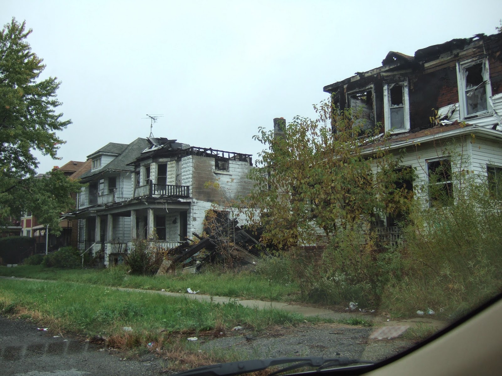
Despite the grimness of the much of Detroit there are remnants of greatness and, in places, signs of revitalization. Not enough to overcome the large population decline in many of the neighborhoods, but clear indications that the city may have hope of entering a period of split personality with a revitalized core surrounded by depopulated neighborhoods extending to the suburbs.
 
Most of Michigan Avenue, the main arterial from downtown to the west, is lined with abandoned and sometimes burnt out buildings from the west edge of the city to very near the downtown core. But just west of downtown the Corktown area appears to be redeveloping in a manner not so different than other formerly declined neighborhoods in many other cities.
 
And we did like the name of this pub.
 

The Detroit Institute of Arts http://www.dia.org/ has been targeted by creditors to the city as a source of funds. For the time being it appears that the City will not be selling off its art collection. The museum is one of the finest in the United States and its loss would be far more than a loss for Detroit. Three counties in the region have chipped in via voter approved taxes to increase the museum endowment fund.

A few favorite American landscape painters:

Lonely Pine by George Innis

Cotopaxi by Frank Church

Indian Telegraph by John Mix Stanely
 

Kaaterskil Falls by Sanford Robinson Gifford

Cascade in the Forest by John Frederick Kensett

The neighborhoods from downtown to the Art Institute and around Wayne State University were very appealing and if that was all you saw of Detroit the impression would be that of a great city.


A bit to the north is the enclave of Highland Park, a city very nearly surrounded by Detroit. A drive through the Boston Historic is a chance to see a wide, mansion lined street.

 
The mansion lined street is very attractive. However, Highland Park is in many ways even worse off than Detroit. An early Ford auto plant was a major source or tax revenue for this city, but its closing as well as depopulation of the small city from over 52,000 to approximately 11,000 has left swaths of derelict homes and apartments just one or two blocks from the mansions in the Historic District. The City has been run by an Emergency Manager appointed by the State of Michigan since 2001. A massive change in fortune since the heady days of the 1910 to 1930.

We ate at Telway Hamburgers twice

One other consistent bright spot can be seen just to the right of Telway Hamburgers (4 burgers for $3). Perhaps a sign of the times, but despite the population loss and mostly abandoned commercial districts the economics of our drug industry is healthy even in Detroit with numerous newish drug stores one of the few new buildings consistently present through various neighborhoods.

Quiken Loans has invested heavily in the downtown area. The company appears to be making a difference in the core of the city, but it is still very hard to visualize how many of the neighborhoods will recover and how those folks who remain can find a better life.

It is my view that it is not possible to reach any conclusions about any city during a short visit. That said, it is always a thought provoking experience to see something different. Detroit holds some lessons. Some of those lessons might be a bit late for Detroit itself, but other cities, and I would suggest even small cities cold learn a few lessons from Detroit.  

Saturday, October 18, 2014

Notes From Detroit

I have been traveling and I am still digesting my time in Detroit. I am not unused to seeing areas that are a bit on the downside. But the scale and the demographic and economic realities of Detroit are still taking awhile to settle in. The thing to keep in mind about Detroit is that its population has declined to approximately 36% of its peak population of 1.8 million in 1950 to less than 700,000 today with a drop of over 200,000 since 2009.
 
So some notes mostly in pictures. I'll put up some positive stuff later.
 

A pioneer spirit despite being on the same street as the homes shown in the first picture


Empty buildings and lots and note the gutted street lights

Scrapping buildings can be hazardous

Th famous and sad Michigan Central Station building http://en.wikipedia.org/wiki/Michigan_Central_Station

Central Station from a different angle

The Book Tower on the left has been completely vacant since 2009

Pedestrian overpass from parking garage to the Book Tower

Geese on an urban street. Grass area was formerly home sites now long gone

Fairly typical scenes in many neighborhoods


Quiet open space area was formerly all urban density homes

A street that has lost all its homes

The nearby arterial street has lost all its shops but not the buildings

Boarded up but still in good shape
Typical listings for homes like this one were between $5,000 and $15,000 and seemed to be mostly dependent on the condition of the neighboring homes

Truck garden and green house on what had been a fully urban street

The level of abandonment is not captured above. There were miles of streets with far more burned out or vacant homes and apartments throughout multiple neighborhoods.

Planning challenges markedly different than the  planning challenges facing most Washington State cities. Where Washington State's Growth Management Act requires planning costs of infrastructure for growing population, Detroit is now having to consider the cost of maintaining urban level services to areas that have been and are continuing to go through negative growth. A difficult challenge as tax base declines. There are some lessons here - just hard to think through.   

Sunday, October 12, 2014

Osprey Bailing Twine Problem Near Ellensburg


I had heard reports of ospreys having the bad habit of collecting bailing twin in their nests fatal-attraction-ospreys-bind-baling-twine-fishing-line. I spotted this osprey nest on a platform built for providing a nest site west of Ellensburg on the broad Manastash alluvial fan. The platform is located within an area of extensive irrigated hay and hence, lots of available twine wrapped into the nest.  As reported in the NPR piece I heard, there has been an effort in Montana to reduce this problem and it clearly is a problem in Kittitas County as well.