Tuesday, December 29, 2020

Geoducks

I have spent a fair bit of time on the high bluffs along the east side of Port Discovery. During some of those ventures a small boat has been off shore in a stationary position with the sound of engines running. At other times the boat is simply anchored near the end of an unpaved road adjacent to a cuspate shore form.  

Landslide complex with cuspate shore form in distance and anchored boat

Port Discovery with Olympic Range in the distance

The boat is used by divers for harvesting a lease tract subtidal geoducks. Dave Williams has an excellent write up of the history and management of the resource (pugetsound.org/geoduck-clams). The shellfish can be harvested during very low tides without diving.  (b-roll:-geoduck-beach-harvesting-aquaculture). However, a fair bit of the harvest is via dive boats at lease sites (youtube.com Geoduck Diving Harvest). The geoduck fishery is managed by Washington State Fish and Wildlife as well as the owner of the subtidal lands, Washington State (dnr.wa.gov/wild-geoduck-fishery)

The first time I tried geoduck was via a gift from shellfish business I did some geology work for. I have since dug for them a few times during very low tides. They are a fun prize to pull up out of the sand. One big goeduck is more than enough for a meal. But those big geoducks take many years to grow. As their value has increased management of the resource has become more important.    

Saturday, December 12, 2020

From the Columbia River to The Fraser River in 1824 - John Work

I roughed in the route of a 1824 Hudson Bay Company expedition from Fort George, the former Fort Astoria trading post, to what was later to become Fort Langley via Journal of John Work, November and December, 1824 via T.C. Elliot, 1912

Part of the scheme was to find the location of a trading center fort on the Fraser River that could receive export goods (furs) from the interior of western North American. Hudson Bay Company (HBC) was already concerned that the lower Columbia would end up in American possession. In part because Fort George was originally an American establishment. In addition, at that time navigation from the sea to the lower Fraser was far superior to the harrowing crossing of the entrance to the Columbia. However, while the Fraser River was a better sea access point, the Fraser River was not a good river transit route.  While a fort ultimately was built, Fort Langley, the Fraser proved to be an impossible navigation route from the interior.

The journal is a window to a different time, and for that matter a different place. I have been fascinated by the diversity of the people and interactions that took place in the brief period from 1790 to 1825. The assembled team for the venture clearly had a pretty good idea of the route they should take. The team included several Hawaiians (Islanders) as well as an Iroquois hunter and his slave.   

Note the time of year they traveled, November-December. While it does rain in November and December in western Washington, the outer coast and the southwest part of the state gets 'heavy rain', a term that Mr. Work used in his journal of his venture (correct spelling of his name was Wark). This was a hardy group. I contemplate how I would have performed portaging across wet ground and along shorelines, rowing for many miles, and camping in the rain, the heavy rain.   

Sunday, December 6, 2020

Rosario Fault on Crane Island north shore

During a work venture in the San Juan Islands I got a nice look at the bedrock along the north shore of Crane Island. Crane is a rocky island between the southwest end of Orcas Island and the northwest shore of Shaw Island. The ferry between Orcas and Friday Harbor passes along the south shore of Crane, but on this venture I was in a small boat and we ventured along the north shore. 

Crane Island is mapped as Constitution Formation on both the Bellingham 1:100,000 map (Lapen (2000) and the Roche Harbor 1:100,000 map (Logan, 2003). And both maps denote the Rosario Thrust Fault immediately to the north of Crane Island 

Portion of Bellingham Quad geology map (Lapen, 2000)
KJmc = Constitution Formation, JTRmcto = Orcas Chert, pPscg = Garrison Schist, pDit = Turtleback Complex, Qgd = glacial drift. Heavy black lines with saw teeth are thrust faults with teeth on upper plate.

Portion of Roche Harbor Quad geology map (Logan, 2003)

The Rosario Thrust is where the Constitution Formation has been faulted up over the Orcas Chert. The fault zone is a zone of highly sheared rock that in places include slivers and slices of other formations caught up in the fault zone such as the Garrison Formation denoted by Lapen (2000) on Shaw Island south of Crane Island. 

My observations of the fault zone exposed along the base of the steep north slope shoreline on the north side of Crane were consistent with other areas where the Rosario Trust Fault is well exposed along the shore near Rosario on Orcas Island (hence the faults name) and along the southwest shore of San Juan Island. The shoreline areas typically offer the best exposures of the fault zone.     

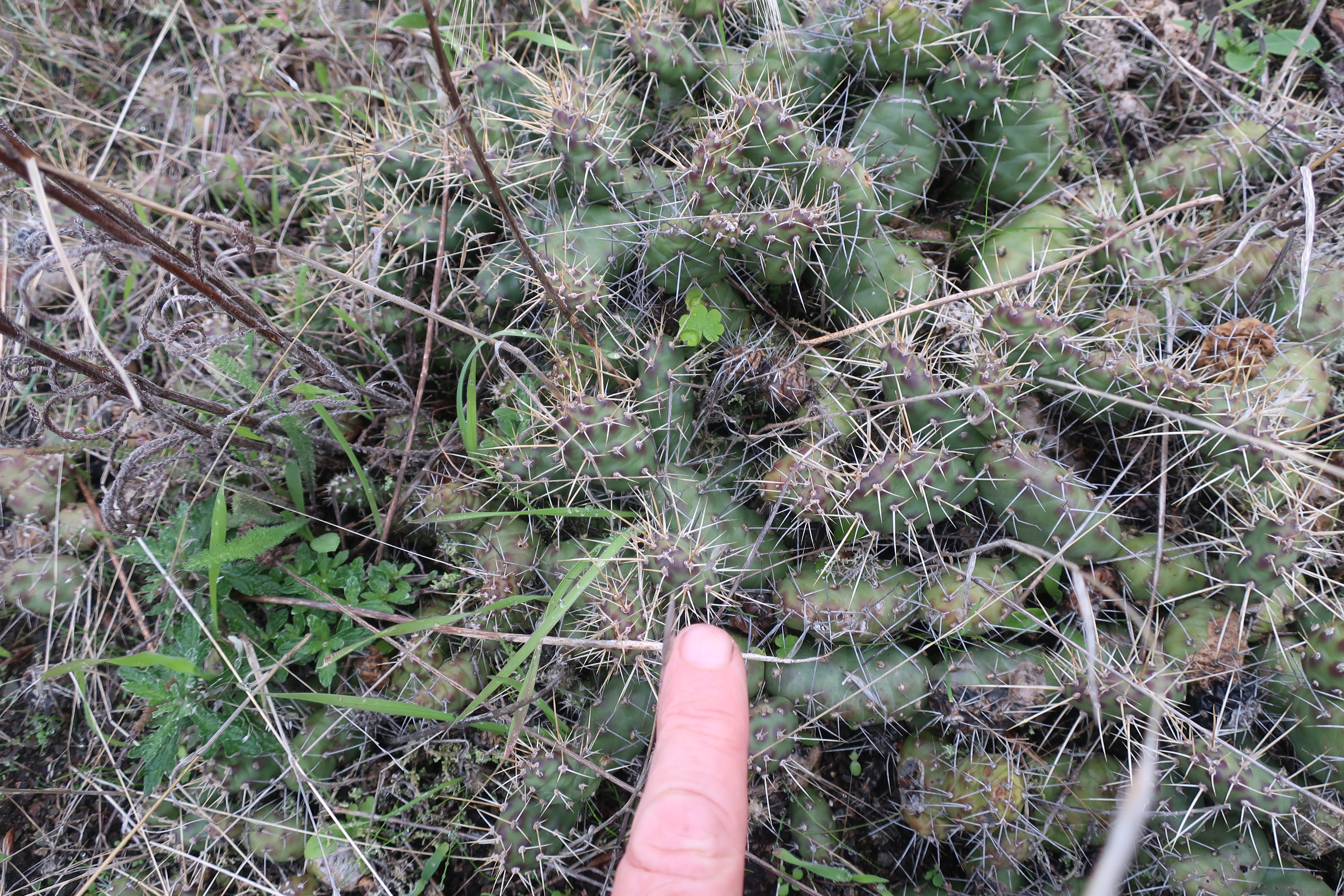
Highly sheared rock within the Rosario Thrust along the north shore of Crane Island

Brecciated and sheared bedrock at water line

Massive block of Constitution Formation above shear zone

On the uplands of Crane Island, the bedrock is generally massive metamorphosed sandstone of the Constitution Formation.  

Typical massive silica-rich metamorphosed sandstone

Orcas Chert is primarily composed of ribbon chert, alternating layers of silica rich 1 to 2 inches thick with thin layers of shale. The chert is derived from the accumulation of silica diatoms that accumulated on the ocean floor. The shale was derived from fine dust and silt that also reached the ocean floor. The layering developed after deposition when the ooze of silica rich and silty sediment was compacted. The age of the Orcas Chert is between 180 and 280 million years old. The Orcas Chert is part of terrain consisting of the related Deadman Bay Volcanics, which are ocean floor pillow basalts that are somewhat older than the Orcas Chert and likely formed the basement that the silica rich sediment that formed the chert unit was deposited on. The original depositional setting was an ocean floor area far from North America. The formation was moved to and accreted to the edge of North America via plate tectonics. During accretion the Orcas Chert was metamorphosed at high pressures.

The Constitution Formation was also originally an ocean floor assemblage; however, this unit is on the order of 130 million years old. The Constitution Formation consists predominantly of metamorphosed fine sandstone derived from a volcanic arc. There is some chert and basalt in the unit as well. This formation was also accreted to the edge of North America. A lack of older aged sediment, North America sediment, suggests the sediment may have been derived from an ocean island arc. 

The Rosario Thrust Fault and the juxtaposition of the Orcas Chert and Constitution Formation took place after accretion -- note that the younger Constitution is thrust over the older Orcas Chert.    

The map pattern shows that Crane Island is klippen of Constitution Formation on the underlying Orcas Chert. Parts of the Constitution Formation have been stripped away leaving the Constitution Formation as an 'island' on the Orcas Chert and as well as the rock formation that makes up most of Crane Island. 


Sunday, November 29, 2020

Political Sunday: Remembering Malden and Pine City Okanogan Valley


Malden Post Office before the fire

NPR did a brief story on Malden, Washington and the lack of a National Major Disaster Declaration after the wildfires in Washington State in early September (HERE). The wildfires in early September burned nearly all of the town including the town hall, post office, food bank, library and fire station. Pine City, a few miles away also was badly burned and one fire burned across 60 miles of Okanogan County and into Douglas County including burning into the City of Bridgeport. 

The NPR story provided no explanation as to why a National Major Disaster Declaration has not been issued. One theory is politics because Washington State votes Democrat of late and the President does not care for the governor; however, Malden is located within a US Congressional District represented by Cathy McMorris-Rodgers, a Republican. The Okanogan area is represented by another Republican, Dan Newhouse. Malden voted 2 to 1 for Donald Trump for President over Joe Biden. So if the reason is politics, it is doubly unfair. Ms. McMorris-Rodgers stated shortly after the fire "I will be working with and supporting state and local officials and doing everything I can on the federal level to ensure our communities have the resources they need to rebuild." She, did sign along with the entire Washington US congressional delegation a letter to Mr. Trump in support of Declaring a Major Disaster (murray.senate.gov/letter).

So far Malden does not have the resources to rebuild. The town had an early burst of development when the railroad came to this location with a rail stop in 1906. After the railroad pulled out their facilities in the 1920s, the town declined. There is no commercial activity remaining, but with over 80 homes destroyed, Malden will have a hard time bringing their community back without help.


Saturday, November 28, 2020

East Sound Fjord

I previously put up a post on the fjord-like feature of East Sound HERE. This fall I had a chance to get some better on the ground perspectives on this fjord.

View across fjord looking east from the slope of Mount Woolard across the fjord to Mount Constitution

View of southern end of fjord with Cypress Island in the distance

View down the fjord from Lookout Hill 600 feet above the fjord

View across the upper north end of the fjord from Lookout Hill to Mount Constitution

The bedrock on Lookout Hill may have at least in part originated from northern Europe or Greenland. The bedrock consists of Turtleback Complex. Age dates from igneous rocks in Turtleback Complex have a huge age range with dates ranging from 350 million years to 500 million. The older ages do not have western North American correlatives. The Turtleback Complex is one of several old accretion terrains along western North America. Some of these terrains may have a connection with the Baltic region and/or the northeast part of Laurentia. Schermer and others (2018)  provide an overview as part of their study on the Yellow Aster Complex in the North Cascades.  


Saturday, October 31, 2020

Typhoon - Welcome to the Endgame

Kyle gives us a bit of what he has been working on during this strange year (https://wearetyphoon.com/): "This song belongs in the present moment and it felt important to get it out in the world now." I have found music and art to be of great help during this past year, but the interface has been altered by COVID. If you can, support the musicians and artists that help shape your perceptions. 

A bit of lower Columbia River landscapes in the video with the song. The tunnel and tenor of the song does fit well with this next Tuesday. We will see what is on the other side.

Friday, October 23, 2020

The Sounds of October

This is my second October living full time at our current home. October is a month of change. Yes, the colors change. Maybe golden leaves on the the big leaf maples. The initial fall rains flipped the brown grass to green. 

But the big change that has gotten my attention are the sounds: 1) The early rains brings out frogs. The tree frogs begin some chorus activity before the colder air shuts things down again - no calls tonight as the temperature is down in the 30s and perhaps 20s by morning.  2) One of the abrupt sound changes is the early just as it gets light sound of guns. Our home is near tracts of State Fish and Wildlife lands as well as a hunting club property and farmland that allows hunting. October brings hunters to sit in blinds awaiting ducks and geese as well as a few pheasant hunters that venture to the brushy thickets between fields. I picture them sipping coffee or whiskey waiting for the ducks or geese to fly near. 3) Another abrupt change is the roar of wind through the forests west and south of us. This evening the wind is coming out of the north - calm around the house but very audible from the upper tree canopy. When the wind really cranks up from the south, a flute like sound emanates from the east side of the house. 4) My favorite is the great horned owls calling in the forest at night. 5) The massive flocks of snow geese honking overhead a week ago in the early morning made me think "welcome back from Siberia".   

Wednesday, October 21, 2020

An Unexpected Encounter with Opunntia fragillis

I had a venture on Orcas Island (One of many this year). These trees on the edge of a rocky shoreline slope got a bit of my attention distracting me from the geology.


The evergreen is a Douglas fir. Likely a bit sculpted by wind and occasion salt spay and the rather harsh growing conditions on a bedrock slope with very thin to no soil. The woody brush was what got my attention. 

Oak leaves!

The brush was a group of low growing oaks. As far as I know Quercus garryana is the only native oak in Washington State and I observed numerous oaks in the near vicinity of this patch. The patch of woody brush appeared to be heavily browsed by deer and this can modify the growth habits of the browsed upon trees. Deer can be pretty good bonsai artists.

When I took the picture above I stuck my fingers into the image for scale. I did not see another plant tucked partly under the low oak. It was only after pulling my hand back that I noticed the plant.  

Opunntia fragillis - Brittle prickly pear cactus

This was a first for me on Orcas. I have seen this cactus on Lopez Island and Decatur Island. I had help spotting them on those previous sightings. The picture below shows that the cactus does not stand out.
  

Once I spotted the first patch, or it spotted me, I started looking for other patches and found several. 


The cactus was was often just above the salt spray line. Just enough of a harsh spot to not get out competed by other plants. The Orcas site is on the drier side of the island as the island is situated within the rain shadow of the Olympic Range. 
 
It is a pretty rare plant in western Washington and is limited to the Olympic rain shadow with reports of the cactus on Whidbey Island and northwest Jefferson County on the Olympic Peninsula. This species is also present in the Okanogan area of north central Washington along with a couple of other species of cactus. Its presence in the Okanogan indicates it is highly tolerant of cold weather. 

Perhaps this species pioneered the barren ground after glacial ice retreated and has only hung on in places where other plants have had a harder time. There are theories that these plants on the west side may have been partially nurtured by First Nations peoples. Given the above setting, that seems very possible as it was an appealing site.


Domico, Terry. Brittle Prickly-Pear Cactus (Opuntia fragilis) in the San Juan Islands and Puget Sound Region of Washington State. Douglasia Occasional Papers, Vol. 7, No, 1, pp. 37-50, 1999. 


Saturday, October 10, 2020

West of North Beach, Port Townsend

With cool early October nights, a flow of marine air from the ocean and perhaps some enhancement from California wildfire smoke, I had a very foggy venture along the shore of the Strait of Juan de Fuca west of North Beach Park in Port Townsend.  


Moisturizing air

The eroding shoreline bluffs allow for great cross section views of glacial related sediments.

Three units exposed on bluff slope from bottom to top: Glacial till, glacial marine drift and emergence deposits

The till was deposited directly by glacial ice when glacial ice from the high coast mountains of Brish Columbia flowed across the area between 18,000 and 14,000 years ago. 

The glacial marine drift was deposited when the ice thinned towards the end of tha last glacial period. The thick ice mass had depressed the local land surface hundreds of feet and when the ice thinned the area was inundated by sea water with glacial ice floating on the sea water. The melting floating ice rained sediment onto the sea floor forming a deposit called glacial marine drift. 

The glacial marine drift is compositionally the same as till, but the till has been compacted by the overriding glacial ice. The glacial marine drift is hard as well as it self compacted by wetting and drying. But that self compaction forms fine fractures within the hard drift.

Fractured and cracked glacial marine drift

The land rebounded after the ice left, and the glacial marine drift emerged from the sea. The upper layer of the drift was reworked by waves and tides for a brief period and the finer silts and clays were washed away leaving the gravel and cobbles behind at the top of the marine drift as emergent lag deposits. 

A bit further to the west another unit presents itself.

Chaotic mix of silt blocks and occasional blocks of glacial till embedded in gravel  

These deposits are great example of and a reminder of the force of under ice water flow. The Juan de Fuca ice lobe and the Puget ice lobe were melting as they advanced and retreated from the area. Much of that melt water would have been flowing under the ice as a confined and powerful hydraulic force that would tear up the underlying sediments. The shoreline reach between North Beach in Port Townsend and just past Middle Point to the west is one of the best exposures I have seen. Indeed it is hard to imagine a better one given the long line of well exposed geology on these eroding bluffs. 

This shore reach is fairly well visited. Even on a foggy chilly morning I encountered others venturing along the shore. Many of the beach walkers are pretty locked into the beach looking for various treasures. As one heads west the beach sands and gravels present polished glass and is locally referred to as Glass Beach. The glass is derived from an old dump site as well as some less concentrated dumping including vehicles.

Tuesday, October 6, 2020

Split Rock Okanogan

I had to do some navigating of backroads in Okanogan County. One road I took was called Split Rock Road. It was not until I reached the far end (or near end depending on where one starts) that I understood the name of the road. Made total sense. 


The rock was sitting atop one of several glacial terraces and is a glacial ice transported rock. It is a local rock so does not meet the technical definition of 'erratic'. The rock is Tonasket Banded Gneiss, part of the Okanogan Metamorphic Core Complex of north central Washington. 

Saturday, September 5, 2020

Diverse Commutes This Week

 Washington State does have a diverse landscapes. That was very evident on two very different morning commutes this past week. 

Start of the day with temperatures heading towards upper 90s. This area gets just over 6 inches of annual rain 

Note the hazy lower sky - smoke from a fire to the west. Based on the fire location I altered my route back home to avoid breathing the smoke.


The fire on Yakima fold belt ridges southwest of Ellensberg.
Buildings are hay storage facilities. The dry windy climate is excellent for high quality feed hay.

This fire brought some smoke to western Washington a couple days later when the overall air flow reversed and flowed from east to west. For the most part this summer has been a low smoke year in Washington State.  

Next morning a very different commute. Heading across the Puget Sound to the Olympic Peninsula. 

Sunday, August 30, 2020

In A Landscape

 In A Landscape shows this summer were canceled due to covid. I had been looking forward to seeing a show this summer after seeing a show in Strabuck, Washington last summer (HERE). We took the opportunity to join a small group at Summer Lake, Oregon to see Hunter Noack play at his summer base. A delightful three evenings of music at the northwest edge of the Basin and Range. On the last morning we took in the Summer Lake playa with classical piano. I very much appreciated the effort In A Landscape put into this project and making a very safe experience in hard times. A very rare pleasure this year for sure. A few clips from the last morning:


Friday, August 28, 2020

Point Roberts in the Time of Covid

I had a project along the West Bluff of Point Roberts. The West Bluff continues to the Canadian border with the bluff near the border called Boundary Bluff. All in all a nice beach walk.

Boundary Bluff and the shoreline along the west side of Point Roberts

Point Roberts is a high bluff point of land that sicks down south of the 49th Parallel from the lower mainland of British Columbia. The point of land is part of the United States. Walking north there was nothing on the beach indicating the border with the exception of a battered sign facing north warning about the border and laws. 


A navigation marker denoting the border is located well out in the tidelands. 


While Boundary Bluff is a fairly natural setting, there are two 4,000 feet+ causeways on the Canadian side of the border extending out to deep water. Both are visible in the above picture. The near causeway leads to the Tawwassen ferry terminal with sailings to Vancouver Island and the Gulf Islands. The larger causeway terminal is more visible with a large container transfer facility that transfers containers from ships and trains as well as coal export facility. 

The top of Boundary Bluff is accessed via a road, Roosevelt Way, that is just on the south side of the border with the back yards of Canadians on the north side of the border.  


A trip to Point Roberts and back requires four border crossings: into Canada at Peace Arch, then into the U.S. at Point Roberts and then back again. With Covid travel restrictions the border is closed for all non essential travel including between the main part of the U.S. and Point Roberts. Assessing geology hazards for a project is deemed essential, and I was allowed entrance into Canada with no stops. So I had to pass on a stop at Tim Horton's. The above said and knowing that the border was mostly closed it was still a shock to be the only car crossing at the typically backed up Peace Arch crossing. 


Wednesday, August 26, 2020

DEM of non survivable storm surge

To get a sense of the potential inundation of a non survivable storm surge I set the storm surge at 15 feet for the Louisiana-Texas border region on a DEM map. First image is typical shore,second is with 15 feet inundation. 


Sunday, July 12, 2020

Political Sunday: Policy and political empathy

"The heart of politics is not about policy. It's about values. I can disagree with you on eight out of 10 issues, but if you're an honorable, honest, empathetic human being, we can do business." - Charlie Sykes quoted in an opinion piece by Frank Bruni.

During my political era, I did concentrate a great deal on policy and I still work on range policy issues. I great deal of good policy work gets down into the details. Those details matter. Good policy requires honest assessments of those details, but it also requires empathy.

Good business requires honest assessments and empathy. Politics and policy are really not that different. A lot of failed policy efforts forget the empathy part or the honest assessment part.

Likewise, good politics require empathy as well. Of late I have been feeling empathy for conservatives. It can not be easy under the circumstances we find ourselves in.   

Monday, July 6, 2020

Skagit City

I got a bit away from posting over the past three months -- busy and too easily distracted.

Reviewing maps along a portion of the Skagit River, I noted a place label called Skagit City.

Mount Vernon Quadrangle map

Skagit City 1890 (via Skagit River Journal)

Skagit City faded away after large log jams were removed from the river upstream at what is now Mount Vernon.

Approaching Skagit City. The main part of the town would have been to the right where the high flood levee embankment.

Once the jams were removed at what is now Mount Vernon boat access was extended up river and thus reduced the attraction of the town site. Further decline took place with the coming of rail. And the location of the town on the delta of a large river subject to very large floods likely did not help either. All that remains is a reference on the topographic maps.

Nice write ups at the excellent skagit river journal.com, a regular go to source of information.

Wednesday, April 22, 2020

Winter Notes From the Skagit Delta and Spring Tulips

Winter is well over now. A quick sum up of this winter's weather in western Washington: September was very wet - so wet that on the Skagit and Samish Flats the potato harvest was not completed due to saturated fields that prevented harvest equipment from being able to operate. The rest of the fall reversed course including into December. It was not the typical days of rain and gloom but instead was mostly dry and mild. January made up for the dry fall with relentless rain that led to a fair uptick in shallow landslides. A brief week of cold spell followed with, at least at Samish, a string of snow storms that kept me home bound for a few days when the snow got above the front bumper. The rest of the late winter and spring was dry. 

A key to farming on the Skagit and Samish Flats is getting out on the fields. The early dry spell meant an early start to working the rich delta soils. It also meant upon my return from eastern Washington getting behind slow farm equipment on the road.    


The sloe pace of 10 miles per hour gave me a chance to enjoy the scenery including views of tulip fields.


Although the day was bit overcast the ground was warmed up enough to cause a distant field of red tulips to appear to levitate.


Tulips are a business. The above field had been harvested for cut flowers earlier in the day. Eventually the bulbs are harvested as well. Hope this will bring some brightness to our Covid times and the workers in these fields stay healthy.