I came across this partially completed painting in Milano, Stream of Humanity by Giuseppe Pellizza da Volpedo. I had seen this image before on a blog post by economist Brad DeLong that I riffed off of for a post We Are the 100%.
Stream of Humanity Giuseppe Pellizza da Volpedo
The painting I saw in Milano was an incomplete version of a better known final painting that Pellizza da Volpedo called The Fourth Estate, a painting of striking workers marching in the street.
The Fourth Estate Giuseppe Pellizza da Volpedo
The City of Milano purchased The Fourth Estate in the 1920s and it subsequently has become a bit of an iconoclastic image used for showing the potential power of the working class. Hence, Brad DeLong used it with the term we are the 100%. If only more of the political class would follow this motto, we would all be a bit better off. But that requires the same of the voters. And perhaps it also requires empathy for the 100% as well.
A pleasure of long distant travel is the time to dedicate to reading. A good novel while sitting in the middle seats of long flight makes the experience a bit more tolerable. I very much enjoyed the novel All the Light We Cannot See by Anthony Doerr.
There was a period when I was always in the midst of reading a novel. That reading pattern has fallen off because unless a novel really grabs my mind I will give it up. This book easily broke through that stoppage. After the initial start on the plane, I found myself picking it up to read to the finish at every small opportunity.
The title is in reference to the electromagnetic spectrum. The story takes place in the run up and though WWII.
There was a line in the book that was used twice that in a way reminded me of my own science experience: "A scientist's work is determined by two things: his interests and those of his time".
a) Mount Rainier
b) Mount Adams
c) Mount Saint Helens
d) Glacier Peak
e) Mount Baker
f) none of the above
A hint is this small active volcano was observed a bit before.
The answer is none of the above. The large volcano is Etna on the island of Sicily. The steaming island is Stromboli.
The flight and views makes one contemplate geologic risk and society in different circumstances. I was struck by the engineering that must have gone into the development of this valley.
Geologists are not the only ones that appreciate a paragneiss that has partially melted.
This stone counter top was one of several that were displayed in a friend's kitchen design studio. It can a bit tricky interpreting counter tops with little context as to the source of the stone. In this case the stone has been cut to emphasize what I believe are former sedimentary layers. Alternatively the layering could be from magma flow or cumulative layering. The counter edge shows that the counter top has been cut oblique to the layers and this the layers appear thicker than they really are on the counter top.
I enjoyed some a well curated political art exhibit. When Communists Dream by Walter Womacka was a favorite. It likely was viewed with approval by the former DDR government at the time.
This sculpture of a well known theme was well rendered.
Political movements and the people caught up in them can be like herds of sheep. But there is within any political movement pressure to keep the mask on to fit in. Taking off the mask, one runs the risk of being found out as not part of the team. One can look at the person that breaks from the herd as a leader, but more often than not they are simply no longer in the herd, and in some circumstances the punishment for leaving the herd harsh.
This painting by A.R. Penck is interpreted as a declaration of autonomy. I can accept that, but mostly I simply liked it.
I paused for a long spell at a small bronze entitled Huricane by Jenny Mucchi-Wiegmann
I make it down to Sinclair Inlet for work a few times every year. The inlet is across Puget Sound from Seattle. Bremerton is on the north shore and Port Orchard is on the south shore. I took a break and walked out on the public dock in Port Orchard. The dock is a relatively new dock for public use.
View back towards the slopes of Port Orchard with the waterfront Cheers Bar and Grill
An interesting aspect of Port Orchard is it provides great views of the Naval Ship Yard. It is a busy place with ships lined up for maintenance and repairs. I always enjoy hearing the periodic revelry carrying across the water.
A northwest Washington point of pride in Whatcom County and Skagit County is noting that area on the border of the two counties is where the Cascade Mountains touch the sea.
Where the mountains touch the sea
Chuckanut and Blanchard Mountains on the right horizon
Lummi Peak just right of center
Mount Constitution just left of center
A range of low mountains extends west of the North Cascades in the area and reaches the Salish Sea. The range extends out into the San Juan Islands. The ridges and summits are relatively modest with summits near the water just under 3,000 feet with higher ridges inland and lower summits in the islands. Never the less the range forms a belt of rugged landscape that cuts across the otherwise continuous north-south Willamette-Puget lowlands that extend the entire length of the west side of the state.
Interstate 5 weaves through the range through a narrow low gap between Skagit County and Whatcom County. Another road, State Highway 11, or Chuckanut Drive, follows the coast at the base of Chuckanut Mountain along the shore of Samish Bay and Bellingham Bay. It ranks as one of the most scenic drives in the State and is a route I have never tired of. It also has lots of unstable slopes and rockfall hazards.
There is no formal name for the range and it really is a combination of uplifts and tectonics that overlap in a manner that does not brink out a distinct name. Locally the westernmost range that descends to the water at Chuckanut Drive and is passed across by I-5 is often called The Chuckanuts.
On a broader scale that incorporates the wider western extension of summits utilizes the term Northwest Cascades. I utilize that term more frequently as it gets at the distinct geology although extremely complex geology and can very reasonably be extended to cover the rugged peaks in the San Juan Islands. This more geologic term is extended to the east to the Straight Creek Fault, a major strike-slip fault with markedly different geologic units on the other side to the east where the core of the North Cascade Range begins.
Coming across a berry snack while in the field in December is always a bit of pleasant diversion.
I do a fair bit of work on the east and north side of the Olympic Mountains. Vaccinium ovatum is not only common as an understory plant, it can be the predominant plant in some areas.
My sense is that the plant does like moist ground, but a good dry spell and warm summer air gives the plant an edge compared to others. The waxy leathery leaves suggest drought tolerance. The evergreen habit allows the plant to take in solar energy during the winter, another edge compared to plants that die back in the winter.
Last week I was asked by an associate if I could send some geology pictures to a student. A rather broad request given the thousands of geology pictures I have in my picture files. What came to mind was perhaps a bit random, but deviated from my Washington State geology and geology hazards pictures.
During my time at Petrified Forest National Park I was fascinated by erosional pedestals formed by hard blocks of rock (in some cases the rocks were petrified wood) protecting much weaker underlying rock or sediment.
The warm spell last week combined with rain and mountain snow melt brought numerous rivers up to near or just above flood stage in western Washington. The Skagit River took a bite out of a section of Highway 20. Several pictures of the damage plus the high water associated with the damage were being circulated by agency and other up river folks. The email strings did not provide specific references to the photographers so I can't attribute as I would otherwise like.
The location of the channel migration erosion is just upstream of the Cascadia Farm seasonal fruit stand for those familiar with the highway. The river has been hard up against the highway at this location and is within a river reach with wide channel migration bends and curves with a flood plain valley over a mile wide with multiple old channels upstream of the confluence with the Sauk River.
Wirth and others (2017) presented various Cascadia earthquake scenario modeling results at the October GSA meeting in Seattle. I scribbled some notes during the presentation. Just where and how deep or shallow the rupture on the fault takes place makes a big difference on the level of shaking that will take place at various locations. By using the model combined with observations of deformation along the coast, this work is refining what various locations might expect from the Big One. Two scenarios presented were for a hypocenter off the central Oregon coast and another with the hypocenter off the northwest Washington coast. The shaking in Seattle would be stronger for the Oregon hypocenter due to how the seismic waves will propagate.
A press release associated with GSA talk provides video of the shake simulations:
Acer macrophyllum or big leaf maple sometimes forms the predominant stand in the forest. These stands can be long lasting in part because the maple trees do not die when cut. Maples will send up an inverted chandelier of stems from the trunk and rapidly form a dense seasonal canopy that appears to effectively block out other competing trees. I am aware of a few stands that are 100 years old. This particular stand shown below grew up out of a clear cut harvest of a mixed stand of mature Douglas fir, western red cedar, grand fir and western hemlock on a moderately steep slope. The maples have since been cut but have grown right back up again.
The geology of the site is an advance glacial outwash sand, a compact sand slope on a very old deep-seated landslide head scarp with an east facing slope aspect.
I had a few ventures onto forestry lands this past week. It can be easy to see the appeal of forestry related work even on chilly damp days. One venture into forest lands was for a couple of projects that did include geology hazards but did involve a long day of hiking and finding bedrock outcrops. The other venture included a group field trip of geologists and land management types to a couple of deep-seated, very large, bedrock landslides and an opportunity to discuss large deep-seated bedrock landslides. Deep-seated bedrock landslides present a complex set of policy issues for geologists, foresters, planners, land managers and public agencies. Thanks to Casey at the DNR for the organizing and logistics.
View across the Skagit Valley
View of Slide Mountain from Sumas Mountain in Whatcom County
View up the the Middle Fork Nooksack valley from Sumas Mountain
and an approaching mix of rain and snow
Looking down on the lower end of the Kendall Landslide
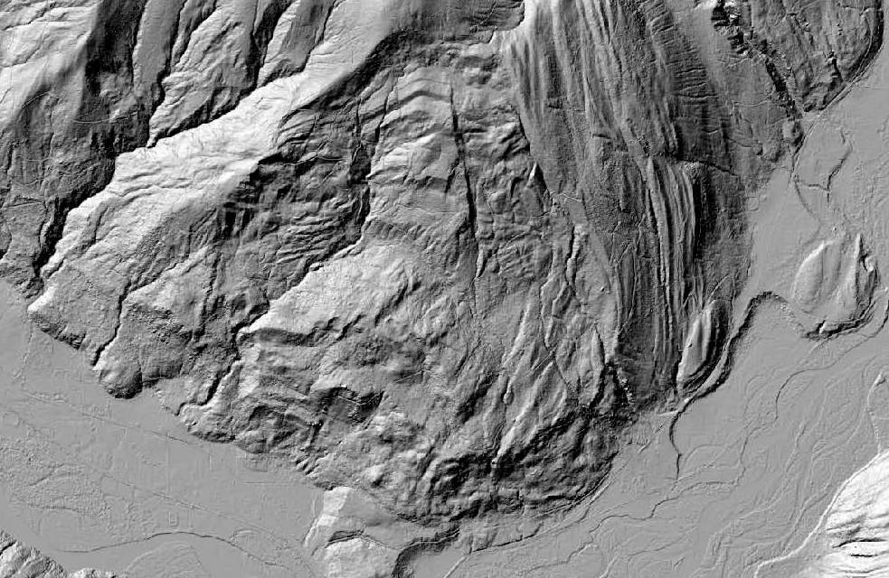
In preparation for a field trip to see and view a few deep-seated bedrock landslides, I pulled up a lidar image of one of the roads we are heading up in order to view another slide. The route takes is into an area that appears to have some slide features as well as a rather fractured looking slope.
Lidar image of south end of Sumas Mountain in Whatcom County
Nooksack River valley floor is in the bottom of image
Noted fluted landscape on the east portion of mountain that is a combination of glacial action combined with resistant sandstone beds of the Chuckanut Formation
Geology map of the area by Dragovich and others (1997)
Geologic Map and Interpreted Geologic History of the Kendall and Deming 7.5-minute Quadrangles, Western Whatcom County, Washington
Dragovich and others (1997) mapped an area between two distinct surface fractures as a landslide. However, the lidar imagery suggests the slide complex extends further west. A later map by Lapen (2000) included the larger slide area.
I have not assessed this slide complex, but did walk along the east limb of the slide on an unrelated assessment associated with a debris flow hazard. A stream flows within the fractured east edge of the slide exposing a dip slope surface of the east side of the slide complex.
Complex topography and one one numerous mountainside deep bedrock failures to consider during our ventures and discussions.
The issue I cared about was the Whatcom County sales tax for building a new jail. That tax failed with the "no" vote prevailing with over 57% opposed. This was a very satisfying win (my perspective). The amazing part is that nearly every elected official in Whatcom County was supporting the jail tax. But three of the the seven County Council members, Barry Buchanan, Ken Mann and Todd Donovan, voted against putting this ballot measure forward.
The real test of leadership will now commence. Can the County Sheriff, Executive and Prosecutor recognize that voters want to go in another direction with the County justice system than the one they advocated for. They are still the leaders on this issue. Those opposed to the jail can only express their views via voting. It is time for county leaders to take actions that reflect the direction of the voters.
Barry Buchanan likely won re election to the County Council. Not bad given that $100,000 was poured into this race by the Washington State Real Estate Association for his opponent.
In Vancouver, the Port race went to an anti oil terminal candidate despite industry money backing the pro terminal candidate.
A few years ago I saw Typhoon (http://wearetyphoon.com/)and have been a fan ever since. The Oregon based band has a set of shows after a long period of no tour dates. Looking forward to seeing them again and hearing their new Offerings.
A significant portions of the lowlands of northwest Washington are underlain by glacial marine drift. To get a sense of how glacial marine drift gets deposited, a little satellite imagery provides a good overview.
Southern coast of Chile
Plumes of silt and clay are poured into the marine waters from nearby melting glacial ice.
Northwest Greenland
Another source of glacial marine sediment is from melting glacial ice floating on the sea surface. Ice bergs as well can provide sediment to the sea floor miles from the glacial front.
In northwest Washington, the
glacial marine drift was deposited during the late stages of the last glacial
period. The mass of thick glacial ice that was on the order of 5,000 feet thick
in the area between 18,000 and 15,000 years ago had isostatically loaded the
land surface such that the current land surface was hundreds of feet lower than
the current elevation.
As the ice thinned the area became inundated with sea
water. Floating glacial ice on the water surface melted and dropped sediment
onto the sea floor. Sediment also was delivered by plumes of sediment rich
meltwater that entered into the shallow water from ice covered nearby upland
areas. Much of the glacial marine drift is predominantly clayey silt but also includes
drop stones and coarser sediment dropped out by the floating glacial ice.
What the lower Skagit valley may have looked like when inundated with sea water.
Ice would have been floating on the water and the ice margin on land would have been very nearby. Glacial marine drift covers areas from Marysville to the Canadian border and includes area in the San Juan Islands and near Port Townsend. The glacial marine drift is a predominant unit around Bellingham.
Post glacial marine deposition, the land surface rapidly rebounded above sea level.
DEM of Skagit Flats and Samish Flats with an upland area between
The upland area is where the Skagit Airport is located
This upland is underlain by clayey silt glacial marine drift
Post emergence, the upper glacial marine drift has undergone some compaction via wetting and drying, such that the upper layers of the glacial marine drift below the weathered top soil layer are very dense and compact.
Very hard glacial marine drift. Note the drop stone pebble.
Also note haw the compaction process has led fractures within the drift
Areas where the unit has remained saturated
such in long term year round wetlands or at depth below the year round groundwater
level have not undergone wetting and drying compaction and remain very soft.
Very soft glacial marine drift in sample tube from geoprobe boring
The geotechnical properties of the marine drift differ from glacial till, and generally allow determination of the difference without the need for fossils. However, it is always fun to find fossil evidence to back up the interpretation.
Worm tubes removed from soil boring in glacial marine drift
Via The Mountaineers Fred Beckey has left us (remembering-mountaineer-fred-beckey). I never met Fred Beckey personally, and I never categorized myself as a climber. But regardless I felt I had met Beckey. During another era I worked in the North Cascades and the three geologists I worked with had dogged eared copies of Becky's guide. At that time I viewed him as a guide to personal terror. He had ventured into extremely difficult terrain prior to our geology ventures and his guide books provided the descriptions on how to get to places that tested my nerves and fortitude.
A few years later I utilized his guide books to navigate into areas not for peak ascents but to explore the geology of a specific area in the North Cascades Range. I did take some pride in navigating an ascent approach within my own field area that even Becky described as an unpleasant route that he backed out of but still provided as an approach route option. The route was not some great climbing route, but was an absolutely miserable 5,000-foot ascent through thick"dog hair" Douglas fir to the base of a glacier where the alpine ascents began. My first attempt of the route ended in miserable retreat. The second time was completed successfully as a solo venture that include my longest stint of no other human interactions after reaching the edge of a the high glacial area below a string jagged Becky first ascent peaks.
While I have looked up to many of his first ascent peaks and routes, I was more impressed with the access routes he pioneered to even get near some of the North Cascade peaks. The challenge of the North Cascade climbing he pioneered was a mix of technical combined with very physically demanding approach routes into and through the deep valleys within the range.
Getting to the many of the North Cascades peaks Becky climbed takes passion and a physical fortitude few people possess. But pioneering these routes also took judgement - very good judgement. That judgment explains more than anything else how Becky survived so many of his adventures and led such a long life. He had the ability to read a landscape without guidance and I am struck by how many of his ventures took place through times when he was young and may not have known better and when he was experienced enough that he could have been fooled by arrogance.
The first half of last week, Sunday through Wednesday was taken up at the Geological Society of America meeting in Seattle. Hundreds of talks and presentations to choose from over a three day period. Deciding on which talks to attend was at times difficult.
One of the early talks I went to was titled Sedimentary Processes at Ice Sheet Grounding-Zone Wedges: Examples From Antarctica and Washington State (U.S.A) (Demet and others, 2017). This talk had some practical applications to my own work on landslides.The talk was a brief version of Demet (2016) thesis work on some of the shoreline bluffs of Whidbey Island.
When the Puget ice lobe retreated the sea invaded Puget Sound and for a time the glacial front consisted of a front of grounded ice (ice in contact with the ground) and a sheet of floating ice. Demet and others (2017) recognized several locations where the grounding line may have been present on Whidbey Island as the ice retreat paused and suggests that the grounding line area became an area where there were some minor readvances of the ice sheet.
A few weeks ago I observed some highly distorted and complex glacial sediments along a steep shoreline bluff along the Strait of Juan de Fuca. Seeing deformed glacial units is not unusual, but the degree of deformation and the cross cutting relationships were perplexing. The area was a mix of glacial outwash, glacial tills and glacial marine drift that was not following the pattern of what is the more typical sequence of units. Understanding the units and just what units I was looking at was a critical component of assessing the potential bluff failure mechanisms. In particular, at this site the presence of poorly compacted glacial marine drift was of interest because it appears to be the cause of some of the larger scale failures that are present on portions of this particular bluff.
The pattern of units appears to be consistent with the observations made by Demet and others (2017). Perhaps a more diligent comparison would be in order.
Jails are very much a part of the Washington landscape (had to get that in). Every county in the state has one as do many of the cities. The county jail is the leading edge of the United States criminal justice system. The jail is a big part of every County budget. Criminal justice and criminal justice spending is complex.
So for Whatcom-centric folks that are trying to decide how to vote the jail tax you can get a couple of perspectives here, but this conversation is at some level very much part of every community (Jail Woes). I am the Vote No Jail Tax person in this video. For a short cut version I have a few major points below.
Cost of the jail will be $250,000 per bed compared to Skagit County at $120,000 per bed. This puts the proposed Whatcom jail as one if not the most expensive jail per bed in the United States.
Tax proponents have stated that some of the tax money will be directed to incarceration reduction programs. There is no guarantee that will take place and the amount suggested is initially $500,000 per year. The amount will go to the jail construction will be $6,759,208 per year assuming the bonds to pay this amount over 30 years can be had at 4.5% and the jail come in on budget.
The existing jails were evaluated by a engineering firm and were found to be "structurally sound and in fair to good condition". They estimated that both jails could be upgraded and maintained at a cost of $32.4 million over a period of 20 years. The cost of the proposed jail will be $202 million over 30 years, and the $202 million assumes no future expansion.
The same engineering firm that reviewed the jail conditions asked the county if a portion of the existing low security jail be improved and hardened for medium security. The 'County officials' stated that the would have to have new public outreach and this was a nonstarter. The fact is the county never evaluated this option in a public manner nor any other options.
When the County did an EIS on the jail they only evaluated options 1) build the proposed jail or 2) don't build a new jail. Given that this project is by far the largest capitol project in the county with broad community impacts that will last generations and evaluating only 2 options is a poor way to make such a large decision. I testified to that during the EIS process.
There are two road routes between Ellensburg and Selah. One is Interstate 82 is the high road passing over Manastah Ridge, Umtanum Ridge the shoulder of Selah Butte. The other is route is very slightly shorter (less than a mile) but slower. That route is the low route that follows the incised meander bends of the Yakima River as it winds through the ridges.
The lower slopes have more water and shade and hence the canyon is a nice mix of scrub steppe with patches of ponderosa pine ecosystems as well as riparian areas along the river. Driving the canyon (or floating) one has a sense of the meanders, but an aerial view shows that some of the bends in the river are very tight.
Much of the east side of the canyon (the road side) is managed by the BLM. The west side is mostly Washington State Fish and Wildlife managed land with some Department of Natural Resources and BLM. The Nature Conservancy also has a presence. The canyon is a popular recreational area for rafting, tubing, fishing and hunting.
Along one of these meander bends I slowed to take in the views of scree slopes just above the road (the slopes in question can be seen above). My geology slow down allowed me to spot two bighorn sheep, a ewe and her now large lamb.
It was good to see them. Bighorn sheep throughout the west are subject to pneumonia outbreaks that are thought to have originated from domestic goats and sheep, but not in a very straight forward manner. The outbreaks and how the bighorns are impacted is not a simple problem nor are the responses (http://bighornhealth.org/publications/). The two Yakima Canyon herds suffered large losses in 2010 (State, federal wildlife officials to selectively remove sick Yakima River canyon bighorn sheep); hence, it was good to see a ewe and her maturing lamb.
Dan McShane is an engineering geologist with Stratum Group, a geology and environmental consulting company based in Bellingham, Washington. Dan has been reading Washington State landscapes since driving across the Horse Heaven Hills with his father and brother in 1970. Dan's wife has started painting Washington landscapes. The intent of this blog is to help all Washington travelers better understand the landscapes we see and share field observations.
Racehorse Fossil Fields- access update
-
July 30 2026 update-. Reader reports say that the round trip walk in to the
fossil fields is now three miles longer due to a new gate on the North Fork
Roa...
Quoting Faith Kearns
-
Communities continue to face different groundwater realities, different
economies and different views about water management. But as groundwater
challenges...
Statement on ISW Methodology
-
*Statement on ISW Methodology*
*May 4, 2023*
The Institute for the Study of War (ISW) welcomes robust and rigorous
debate on the issues ISW covers and i...