Showing posts with label Field Work. Show all posts

Tuesday, January 21, 2025

My Forest Enemy: Ilex aquifofium

While doing field work I come across what I have decided is a personal enemy on regular basis.

Eglish Holly (Ilex aquifolium)

I was able to pull this one out by the roots.

I at times visuzlize the Pacific Northwest forests in 10,000 years being a forest of holly. The holly shown above was in an old growth forest. I have come across holly in old forest areas ranging in elevation from the inland coastal areas to as much as 3500 feet in the Cascade Range. I have been digging it out of my own forest stand on regular basis, and when I can, I yank it out of the ground and stick it into a spot above the ground while traversing through the forest during a field ventures.  .

KUOW covered recent efforts to get this plant listed as a noxiuos weed (kuow.org/have-a-holly-noxious-christmas). The issue strikes me as a state government and ethics failure.  

Saturday, January 18, 2025

Windfall and Dog Hair

I plotted out a route to a steep slope at the headwaters of a creek in the Northwest Cascades. While approaching the site I noted windfall trees on the edge of a clearcut.


While walking the road and a section of trail took about 2 hours to cover 6 miles with a fair bit of elevation gain and hiking out took about 1.5 hours as it was downhill, the last quarter mile to the steep slopes I wanted to reach took nearly an hour each way. 

Windfall trees and dog hair young trees

Dog hair western hemlock obscuring downed trees

It is a slow process navigating over fallen logs and brancheds that tend to break. It did not help that portions of the area were also steep. 

I did reach my goal of getting to the steep headwater slope - that presented its own challenge as there were cliffs in the forest.

Very steep forested slope

Made for a bit of a long day and light got a bit dim before getting back to my starting point, but I did get some nice views as the clouds broke up. 

Whitechuck and Glacier Peak

Whitehorse and Three Fingers

Tuesday, January 23, 2024

Very Large Tree Spear

While doing some field work on a very wet day near the outer west coast I noted what appeared to be another tree spear (tree-top-spear). I do not know if these tree tops or limbs embedded in the ground have an 'official' term, but I apply the term tree spear for them.  

Tree spear is just the right of the two tall trees. 

I made a side trip to confirm what I thought I was seeing.


/

This spear appears to have been the limb of a cottonwood. It was very firmly embedded in the wet ground and did not budge even slightly when I pushed hard against it. The soil here is silt flood deposits.  

Thursday, December 7, 2023

Tree Top Spear

I have seen broken tree tops stabbed into the earth but this one ranks as the most impressive. 


The spear and the source

Sunday, December 3, 2023

King Tides, Storm Surge and Field Work

We are in king tide season. King tides are the higher high tides of the year and winter is when the tides are the highest. The moon is the bigger driver of tides, but the sun is critical in the seasonal variability of tides that result in the highest tides of the year.

The earth is closest to the sun on about January 3 and hence the pull of the sun on the earth tides is greatest on that day. However, the tilt of the earth relative to the earth's orbit results in the Washington coast dipping downward into the maximum tide zone during the winter solstice. Hence, our highest astronomical tides take place in the December/January period.    

Declination and tides from Hicks (2006). 

In the above figure Washington State is approximately at the C-D line. The result is that when we are at position C we are in the king tide zone. 

Other Factors

Storm Surge:  The astronomical tide is impacted by meteorological forcing. A deep low pressure system will result in a higher tide level than the astronomical tide. The wind around the deep low pressure also results in water being piled up against the coast depending on the track of the low pressure. The track of a hurricane center is a very important component of the storm surge associated with hurricanes. The low pressure of the hurricane will result in storm surge but so does the wind. Being on the right hand side of an approaching hurricane (from the hurricane's view) can result in huge storm surges.

The same issue holds true for the Washington State coast. Deep low pressure systems bring lots of wind that will push and pile water up at different locations depending on the track of the low and the wind fields around the low. The impact of deep low pressure storms and associated wind fields on the inland waters of the Salish Sea is complex due to the shape of the multiple waterways. Yang and others (2019) modeled storm surge in the Salish Sea and provide an estimated maximum storm surge map for the Salish Sea.

Figure 12 from Yang and others (2019)

A large storm surge December 27, 2022 resulted in significant shoreline flooding as the storm surge coincided with an already high astronomical high tide event. 

Water overtopping shoreline dike at Alice Bay, Skagit County
(note center road stripe under water) 

Water overtopping shoreline dike at Alice Bay
(note white fog line road stripe under water)

18.61-year lunar nodal cycle: The plane of the orbit of the moon is inclined 5.145° from the equator. The result is that the moon's pull on the tide varies. When the moon is above the equatorial plane the pull is larger. We are currently in a period when the moon is more frequently above the equatorial plane during the king tide period. The result is more frequent tides being extra high this year as well as next and therefore the odds of a very high astronomical tide coinciding with a storm surge are greater this year and next than on average.   

Timing of winter high tides

The tides set the waters of the ocean basins into motion. This moving water pushes up or pulls away continents and up into the inlets like such as the Salish Sea. The actual response of the ocean basins and estuaries to tides is complicated and can lead to some pretty remarkable tides. I recall walking out on a dock in the Bay of Fundy with a 2 year old and being terrified of the potential fall hazard with boats 50 feet below us during low tide. Hicks (2006) provides a good overview of the factors that impact estuary tide levels.  

A peculiar feature of tide interactions in the Salish Sea area I work along most frequently is the lack of low tide during the day light hours of winter. Assessments of shoreline bluffs in mid winter can be complicated by the tides as the plot below shows.

High tide was at about 8 in the morning, but the low tide at noon is not exactly low with second high tide coming in at 3:15 in the afternoon. The main low tide was really low - a negative tide at around midnight. Clam digging or oyster harvest at night in the winter. 

I had a bit of hike to reach the shoreline bluff I needed to visit as there was no access down the very steep and high bluff for a few miles in both directions. I know this shore reach well enough that I figured I could make the 8 mile round trip hike with only the need for limited wading where the beach was narrow. With sunset at 4 the best I was going to get was a tide of about 8 feet. Note that there was minimal storm surge and the other plus was it was a calm day with no ocean swell coming in the strait.  I started the hike after noon. The deepest wade was only shin deep and the waves were minimal. The water was warmer than the steady rain as the air temperature was 38 degrees. 

House lights atop a high bluff above the Salish Sea

I took the above picture while heading back from my venture. I had to hold the camera against a log due to the darkness. The warm glow of the house lights struck me as a nice touch. I still had two miles to go to reach my car.  

While I think most folks would consider that venture just awful, I was completely content. I had reached my destination, figured out the landslide complex and shoreline processes adequately, gotten a good hike in and timed the trip so it could be done. The satisfaction of field work!  

Wednesday, October 25, 2023

An Explosion of Fungi

The fall rains have arrived. On a very recent field venture I came across an explosion of the fungal world exposing itself. I know very little about fungi and mushrooms. My mushroom adventures have been limited to a occasional picking of chanterelles and another type that leads to enhanced neuron activity.

The first mushroom I saw was few scattered large white mushrooms pushing up through the moss.  


After that is was one species after another. With no guide book and limited past identification efforts, I simply enjoyed the remarkable variety of this ephemeral explosion of wonders in the forest ecosystem briefly revealing themselves. Perhaps I will take a run at trying to id some from the pictures for future reference. 


Saturday, September 30, 2023

Opuntia columbiana

While on a field work venture along the Yakima River in central Washington I came across a patch of what I believe to be Opuntia columbia. I felt fortunate to have seen this patch before I walked into it as I was wearing light shoes. I was once no so fortunate while traversing an area above the Okanogan River.     

Patch of cactus on a high gravel bar above the river

I determined that the patch was broad enough and populated enough that it would be ok to extract a paddle.

Long thorns of Opuntia columbia?

I am nowhere near enough of a botanist to know if this cactus is Opuntia columbia, hence, my tentative identification. That said, I am pretty confident based on my review of Burke Herbarium. Desert Northwest provides a nice discussion of the various cacti species in Washington and discusses the botanical debates, but also comes down on this likely being Opuntia columbia. 

I enjoy seeing cacti in Washington State. Cacti do not have much of a presence in Washington even in the dry areas. This patch was growing on a cobble/gravel bar elevated above the river. The site is high enough that flooding must be very rare as there were some large ponderosa pines on the bar. The cobbles and gravel add to the dryness and have kept competition down just enough to allow the patch to thrive.

Saturday, June 17, 2023

Rocks of Bulson Creek and Bulson Creek Falls, Skagit County

I have had several ventures on the steep north slope of Mount Frailey above Lake Cavanaugh in Skagit County. These ventures were to assess alluvial fan hazards which has meant assessing the steep drainages above the alluvial fans. Like much of the Northwest Cascades bedrock exposures are sometimes limited to stream channels. Hence the steep drainages on the north side of Frailey Mountain provided a good opportunity to see the bedrock hiding under the thick forest landscape. The lower slopes of Mount Frailey are underlain by sedimentary rocks called Rocks of Bulson Creek.  


     Bob contemplating our route
Conglomerate of Bulson Creek

 
Note weathered perimeter of greenstone cobble 

The hard conglomerate of the formation forms cliffs and a few nice cascades on the stream Bob and I were exploring. The clasts in the conglomerate are derived from nearby metamorphic rocks of the Eastern Mélange Belt which is well exposed on the slope above this outcrop. The Eastern Mélange Belt consists of Triassic to Jurassic age ocean floor terrane thrust up onto the edge of North America. It is one of several accreted terranes in the Northwest Cascades.

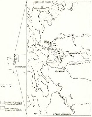
The Rocks of Bulson Creek are Oligocene to Eocene and post date the terrane accretion. The Bulson appears to be deposited on the metamorphic rocks (Marcus, 1981) and appears to be a localized sedimentary in a localized basin that formed during the late to post Eocene time likely associated with the Devils Mountain-Darrington Fault (Lovseth, 1975 and Marcus, 1981). In the Lake McMurray area to the east the Bulson has clasts of Eocene to Oligocene volcanic rocks that are of local derivation.    
 
Distribution of Rocks of Bulson Creek from Marcus (1981)

Lovseth (1975) recognized the Bulson as a separate sedimentary unit than the similar looking Chuckanut Formation to the north. The Bulson is primarily marine while the Chuckanut is non marine. And while the base of the Chuckanut does contain locally derived clasts of Northwest Cascades rocks, most of the Chuckanut sediment is derived from a source area to the east of the Cascade Mountains at a time prior to the uplift of the range. 

The term Rocks of Bulson Creek is from Bulson Creek located along a section of the Devils Mountain-Darrington Fault Zone. The creek incises down through the rocks and providing good exposures of a section of the formation. On the day of my venture up Frailey Mountain I also had a project along Bulson Creek and got a view of Bulson Creek Falls over a layer of hard conglomerate. 

Bulson Creek Falls


Sunday, January 22, 2023

Winter Field Work

I have developed a preference for geology field work in the winter. Geology field work in western Washington State is generally pretty easy. The hardest challenge in western Washington is the thick vegetation. If you do not like smashing through brush, western Washington off trail field work is not the place for you. In the winter the vegetation is less dense with leaves off of the deciduous trees and bushes. However, Himalayan blackberries with their long canes and thorns still present a problem. On a recent excursion to a slide complex my initial thought was navigating on the slide complex might be limited due to the thick blackberry growth over much of the slide area. However, as I made my way onto the slide I realized the mid December heavy snow followed by freezing rain at the site had flattened down the much of the blackberries making my traverses on the slide complex much easier than initially anticipated. 

I still had to high step a bit to get over the blackberries but it was much easier than if done at another time of year. 

I caught another break with winter weather making my traverse easier after a couple of days steady temperatures well below freezing and before a big snow. I muddy slog with mid shin water and muck. I had been across the same area before. Though the site looked very wet the freeze allowed for easy walking across the frozen mud and frozen ponded water.

The weather does not always work out but, there are the other added benefits: no bugs, easier to see where water has been flowing, and not much worry about dehydration.    


Friday, October 21, 2022

Former Placer Mining on the Columbia River

A gold rush in the Cariboo District of British Columbia resulted in an influx of miners passing through Washington Territory in the late 1850s and 1860s. Some of the miners traveling along the Columbia and Okanogan River took to placer mining at the gravel bars along the rivers. Splawn (1917) described 50 miners working the gravel bar at the south side of the Columbia River at the confluence with the Okanogan River in the early 1860s. Much of the placer mining working river bars on the Columbia River was undertaken by Chinese miners.  

Much of those placer mine workings have been submerged as the result of dams on the Columbia River. During a recent project I came across some old trenches on a terrace above the Columbia River well upstream of the Okanogan-Columbia confluence. The 1860s and 1870s placer mines were not documented operations and the archeological record is a bit thin.

I took a look at lidar bare earth imagery and found two obvious placer mine sites -- both partially submerged on gravel bars along the river between Grande Coulee Dam and Chief Joseph Dam.    


The Chinese operated placer miners primarily operated in the 1860s through the 1870s (Evenson, 2016). There are references to troubles with First Nations with one description of a massacre of the miners south of Chelan. Some of the placer sites were further worked in the early 1900s and I suspect that was the case at the two sites shown above. 

Reference:

Evenson, Lindsey M., "Pre-1900s Chinese placer mining in northeastern Washington State: an archaeological investigation" (2016). EWU Masters Thesis Collection. 358.   

Splawn, A.J., "Ka-Mi-Akin, the Last Hero of the Yakimas", (1917)

Friday, September 30, 2022

My First Pronghorn Spotting in Washington State

Antilocapra americana (pronghorn antelope) have been reintroduced to Washington State first by the Yakama Nation in south central Washington and a few years ago by the Colville Confederated Tribes in north central Washington. I finally saw my first Washington State pronghorn last week.   

These two are from the Colville introduction. I had been told that that some of the pronghorns from Colville had crossed the Columbia River and these two were south of the river in northern Douglas County. This area of Douglas has a fair bit of scrub steppe land. The area was glaciated and has large areas of very thin soils over bedrock or thin glacial soils. As such cultivation has been very limited with grazing operations being the main historic land use and very few humans. All and all good wildlife habitat with pronghorns being new entrant after a period of absence.

The Yakama pronghorns have expanded their range as well and the herd numbers have held up post reintroduction (https://wdfw.wa.gov/publications/02288).  

Thursday, January 13, 2022

Snoqualmie Falls at Flood Stage and Cle Elum Digs Out

I had some work in central Washington and had to alter my route due to Highway 2 being closed across Stevens Pass. I added a bit an additional detour as water levels in the Snoqualmie River were very high. 

Road closure in the Snoqualmie River valley 

The detour was a chance to see Snoqualmie Falls at flood stage.


The spray from the base of the falls obliterated any veiwing from the main view spot

Further on my journey I observed Cle Elum still digging out from the snow. Temperatures have moderated and it was just above freezing as I passed through town.