Friday, March 30, 2012

Quick Clays and a Disaster Movie

Some of the worst landslides in history are the result of quick clays. I have been doing some research on why we do not, at least as far as I know, have quick clays in Washington State. Quick clays are associated with areas that were glaciated with thick heavy masses of ice during the last glacial period: Norway, Sweden, parts of eastern Canada and Alaska. The idea is that the huge mass of glacial ice in these areas during the ice age pressed the local land surface downward. As the ice melted these depressed areas were flooded by sea water. Clays were deposited on the sea floor of these areas before the surface area was able to rebound from the mass of ice. Under the right circumstances the clays that were deposited are subject to liquefaction with enormous landslides even on very gentle slopes. Hundreds of people have been killed in Norway and Sweden and dozens in Canada by quick clay slides. In Canada, an entire town was vacated and moved due to the risk and within two years the area completely failed.

What got me thinking about quick clays was this page vitenskap-og-teknologi with a video of a couple of geologists or geotechnical engineers doing some field work on a quick clay investigation. I liked the video as it shows what geotechnical drilling work can be like. The clip shows how quick clays can be readily identified with a simple on site test. Its is a very short video and might be difficult to understand unless your fluent in Norwegian, but will give one a sense of one aspect of geotechnical work.

There is a remarkable video that circles about amongst geo types and includes a bit of a description of how quick clay forms, where it is found, and a lab demonstration; however, the remarkable part is it has footage of a very large quick clay landslide. The video is a bit "old school", but worth watching if your into disaster movies. I really liked the way the remaining hazard areas were stabilized after the slide.

In regards to the lack of quick clay problems in Washington, I want to do a bit more reading on the subject and think through how the glacial marine clays underlying a fair bit of northwest Washington are different.

Thursday, March 29, 2012

An Erratic Breaking Free


Terry McHugh sent me this picture of a glacier erratic that is nearly free of the drift it was embedded within at the south end of Marrowstone Island. This drift was from the last glacial period approximately 18,000 years old. Almost the entirety of Marrowstone is capped by very compact glacial drift. Terry and I have worked on a number of projects in Jefferson County over the past decade plus and I always appreciate ability to understand a landscape before I even show up.

Tuesday, March 27, 2012

Rural Element Pain - Local and Wonky

I went to the Whatcom County Rural Element public hearing last week. This stuff gets wonky, political and bores the heck out most normal people. I lost normalcy on planning issues long ago in part because these processes play a fundamental role in shaping how our landscapes look and function. These decisions set up future areas of traffic jams, place large swaths of land as industrial parks with tens of thousands of jobs, create scenarios that lead to Mount Rainier being tagged as one of the most dangerous volcanoes on the planet because so many people have moved into the lahar risk zone, preserve or destroy farm land, ect. ect.

Back in January the Growth Management Hearings Board ruled Whatcom County's rural plan invalid (digesting-lamirds-wonky-long-and-local). The County Council has decided to proceed with making the needed changes to meet the requirements of the ruling. Most of these changes are fairly straight forward, but the tough nut is dealing with an excessive amount of vacant lots that could contain essentially all of the projected County population growth over the next 20 years and beyond. The Hearings Board identified this as one problem that needs fixing and it is very unclear at this point what the County will do.

Initially the changes must go through a public process via the County Planning Commission. Process wise this is a bit interesting. The rural plan already has been through the Planning Commission process back in 2009. The Planning Commission forwarded their recommendation to the Council in late 2009. The Council spent well over a year altering and amending the original plan, and many of those alterations are what led to the plan being successfully challenged by two groups of citizens. So the Planning Commission gets to look at this plan a second time. This might seem a bit redundant as the planning commission could simply go back to the original plan and to a degree that is what the staff is recommending. However, there are couple of things to note: 1) the Planning Commission consists of people and many members are new and were not part of the original process and are decidedly different in their points of view regarding land use planning, and 2) the Hearings Board ruling has forced the County to deal with aspects of the plan that were not dealt with before.

The County staff presented some suggested changes to the Planning Commission and the public last week at a public hearing. I went to the hearing and provided some testimony and listened to some of the other testimony.

Real Estate Industry and Building Industry reps basically testified that the County should either fight the Board in court or make changes that would be clearly non compliant with the Growth Management Act. These groups have turned into cheerleader of Growth Management Act non compliance and are likely frustrated by those pesky citizens that have prevailed before the Hearings Board.

A fair number of folks in a rural area west of Bellingham testified that development in this area should be curtailed due to poor soils for septic and poor traffic. They made very valid points that are consistent with the problem of excess residential development in rural areas. Indeed soils underlying the area are very poorly drained and septic systems and stormwater are problematic in the area. Traffic issues tend to be relative, but it should be noted that much of the traffic impact is not simply in the local area but ends up in Bellingham, and hence Bellingham has taken the same position.

Jean Melious, an attorney representing a group of citizens that had successfully appealed part of the rural plan had an interesting angle to her testimony. Ms Melious was the chair of the Planning Commission during the last time the Planning Commission dealt with the rural plan. As such she has a bit of sympathy for Planning Commission members. She pointed out that after her testimony she will get to go home while they will have to continue to site through public comment and then have to struggle with all the suggestions they have heard. She raised the political angle as well. This is nothing new in testimony, but she is making it clear the fundamental struggle on dealing with land use issues is often political and in this case it very clearly has been. The majority on the County Council has pushed forward a number of plans over the past two years that have been shot down and invalidated by the Hearings Board. Clearly politics has been contrary to a State law that has been the governing land use law in most of Washington State for over 20 years.

Futurewise, another citizen group that has been part of the successful appeal of the County rural plan (disclosure - I am a Whatcom Futurewise Board member) testified a number of changes that were being proposed as good changes, but did note that excess residential development in some areas poses water quality and water quantity problems for streams and for farmers. This is no small issue when farmers can not get water rights but hundreds of homes can be built with no need for water rights as many can use exempt wells without a water right.

Dave Stalheim provided some excellent population number crunching but more importantly noted a couple scary issues: Whatcom County's rural area is on track to have a population that exceeds Bellingham and the lack of solid planning to deal with this surge of population growth in the rural areas will set up some severe future tax and utility rate problems. Mr. Stalheim is the former Whatcom County Planning Director. In some ways Mr. Stalheim is able to present information in a much freer manner as he is no longer encumbered with the political motives of his boss or the County Council.

I am sure there was plenty of other interesting testimony, but once I had testified and heard a few others I headed home and left the volunteer Planning Commission members to their hard duty - bless them.

My testimony focused on the issue of excess rural land capacity. The planning staff presented the following language for the plan on this issue:

Because of the geographic size of Whatcom County’s rural area and the large number of existing and vested undeveloped lots, the total number of potential new dwelling units could theoretically accommodate population growth well in excess of the rural population projection. However, because adequate land capacity is available for growth within urban growth areas, growth is not forced into rural areas. Through the monitoring process described in Policies 2S-5 and 2DD-1 of this plan, the County will evaluate development activity in comparison with these urban and rural growth projections and take action as necessary to address discrepancies if any are identified.  


Policy 2DD-1:

Concentrate growth in urban areas per the population projections in Chapter 1 of this plan, and recognize rural lands as an important transition area between urban areas and resource areas. Annually monitor residential development activity in rural areas and compare that data with the adopted population projection for the rural areas. If it is apparent that rural growth is occurring at a significantly higher rate than adopted projections, the County shall take action to address the discrepancy. Actions may include: changing the allocation of the projected population growth, changing rural zoning or densities, limiting rural permit issuance, working with cities to foster appropriate growth in Urban Growth Areas through annexation or extension of utilities, or working with cities to reduce the difference in impact fees between cities and rural areas.

The first paragraph recognizes the problem, but the statement that "because adequate land capacity is available for growth within urban areas, growth is not forced into rural areas," is not consistent with the growth that has been taking place over the past decade or more. In fact the urban growth areas around several of Whatcom County cities were determined to be too large and even then the rural growth rate exceeded the projections. This may be in part due to poor city planning or obstacles cities have put up towards development.

What the above does suggest is that the County recognizes the problem and will watch the situation. There is no commitment to do anything. And that is exactly what the county has already been doing. There is no commitment to anything about the problem.

I took a crack at rewriting the policy in hopes of at least getting some movement towards action and presented this scheme along with a few other comments to the planning commission during the hearing. (underlined areas showing new suggested text and cross out suggested text deletions.)

Because of the geographic size of Whatcom County’s rural area and the large number of existing and vested undeveloped lots, the total number of potential new dwelling units could theoretically accommodate population growth well in excess of the rural population projection. However, because adequate land capacity is available for growth within urban growth areas, growth is not forced into rural areas. However, excess growth capacity in rural areas can undermine urban development and adequate capitol facility plans have not been developed to service the excess development capacity in rural areas. Furthermore, population growth over the past few years has far exceeded the projected population growth for rural areas. Based on this rate of rural growth the County shall take actions and continue monitoring growth rates in the rural areas as Through the monitoring process described in Policies 2S-5 and 2DD-1 of this plan, the County will continue to evaluate development activity in comparison with these urban and rural growth projections and take action as necessary to address discrepancies if any are identified.  
Policy 2DD-1:

Concentrate growth in urban areas per the population projections in Chapter 1 of this plan, and recognize rural lands as an important transition area between urban areas and resource areas. Annually monitor residential development activity in rural areas and compare that data with the adopted population projection for the rural areas. If As it is currently apparent that rural growth is occurring at a significantly higher rate than adopted projections, the county shall take the following interim actions to address the discrepancy. Actions may include: 1) limiting rural permit issuance to match projected growth rates and 2) not accept applications for land divisions other than for agricultural lease purposes on an interim basis. Additional actions following these interim actions may include but are not limited to: 1) changing the allocation of the projected population growth; if projected population allocation changes are made, they will be made in coordination with all of the cities in Whatcom County and may require the reduction of urban growth areas, 2) Develop capital facilities and service plans for serving rural areas, 3) changing rural zoning or densities based on available water resources, water quality protection, protection of identified agricultural areas, and protection of identified wildlife habitat areas, 4) working with cities to foster appropriate growth in Urban Growth Areas and within existing cities through annexation or extension of utilities, 5) working with cities to reduce the difference in impact fees between cities and rural areas by implementing school, transportation, park impact fees in rural areas as appropriate, 6) expire old plat applications, 7) consolidate existing substandard lots.

Rationale: The County has for a long time had excess growth capacity within the rural areas of the county. There is clear evidence that rural growth has been exceeding projected population growth. This problem has only been sporadically addressed within limited areas. At this point the county has very limited capital facilities plans for serving such a potentially large rural population. The excess growth capacity must be dealt with in order to protect tax payers and utility rate payers, protect agricultural lands, critical water resources and identified habitat areas. 

Monday, March 26, 2012

Sunny Field Work


Skagit River and Northwest Cascades
Red alders and cottonwoods without leafs

I took advantage of the sunny weather and took off for field work Friday and over the weekend. Feeling a bit smug about it as today we are back to rain and wind and temperatures in the 40s F. Sunny March days are by far the best days for field work in western Washington. And it is more than the fact that the sun has warmth to it so it just plain feels good after the cold days of winter and those days when even though it is sunny the sun is not very warm due to our high latitude. The other factors: 1) visibility in the brush is as good as it gets as deciduous trees and brush have not leafed out yet, 2) it is never too warm this early in the spring, 3) the ground is still very wet aiding in figuring out slope issues if that is the task at hand, 4) virtually no biting flies or mosquitoes, 5) daylight starts much earlier and last much later than the short window of light in mid winter.

Had to do a bit of ice scraping before heading out

By mid day I was shirtless at least while out of the woods at Fisherman Harbor

Easy viewing up slide slope

And the mountains look fantastic, Twin Sisters, Northwest Cascades

Saturday, March 24, 2012

Snow is Gone and Leucistic Robin Has Returned


Leucistic robin on 1400 block Grant Street, Bellingham via Barry 

Headed up the Skagit Valley yesterday to visit a few sites for work. Just did not make sense to be on the writing machine with sunny weather after the bit of cold rain with snow thrown in on occasion of the past few weeks. And I'll be doing field work today as well because the snow is gone and the birds are back - including our neighborhood's Leucistic Robin spotted first by Barry yesterday.
 

Friday, March 23, 2012

We Get Dust Storms Too

NASA Earth Observatory has an Image of the day site http://earthobservatory.nasa.gov/IOTD that is worth checking out. They recently had a dust storm image from a storm on the Arabian Peninsula.

Dust storm between Syria and Iraq

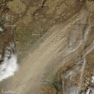
Washington State gets dust storms occasionally as well.

Dust Storm in eastern Washington

I saved this image from the MODUS satellite from a storm that hit eastern Washington in the early fall of 2009. In this case the dust storm was generated by winds blowing in the opposite direction than typical for dust storm events in eastern Washington. In this case the wind was from the northeast. More typically the hard prevailing dust transporting winds are from the southwest.

Strong southwest winds have been transporting sand and silt from the Columbia River Basin near Kennewick and Pasco towards the northeast for hundreds of thousands of years. The very dry basin combined with sediment deposits from the Columbia River have provided sediments for wind transport to the northeast for a long time. Silt in the rolling hills of the Palouse and areas outside of the Missoula Flood scoured land have accumulated in places hundreds of feet. These silts support a huge dry land wheat crop as well as peas and lentils in moister areas. In the storm above, some of the silt is being returned to the basin but also shows that silt can be blown up onto the Horse Heaven Hills south and west of Kennewick. Indeed there is a layer of wind blown silt covering much of the Horse Heavens.

Piles of wind deposited silt in the Palouse of eastern Washington

Silt in road cut shown above

Wednesday, March 21, 2012

Gabbro Near Rocky Prairie Mima Mounds

On a recent trip to Pierce County and Thurston County I plotted my route between project sites to pass by Rocky Prairie on the Old Pacific Highway to check out some more Mima Mounds. I found a spot to pull over, but before checking the Mima Mounds in the prairie I noted a small hill rising up in the forest right by where I pulled out. My initial thought was that it might be a remnant esker or terminal moraine as I was within the far southern reaches of the Puget ice lobe. I meandered towards this hill and discovered it was bedrock. This was not a complete surprise as I knew there were outcrops on the upland areas to the west and southeast.
Bedrock quarry near Rocky Prairie

I was struck by how dark the rock was - nearly black. But it was wet so maybe it was just the wetness. I guessed it would either be 1) andesite as a ridge to the southeast I had been to before was predominantly andesite or 2) basalt possibly Crescent basalt or maybe even a bit of Columbia River Basalt Group (these two formations cover lots of western Washington. I was surprised when I picked up a chunk. It was very dense and heavy. A gabbro - extra iron and magnesium. Hmmm!?

I hadn't checked out the geology map of the area before this trip as my stop was simply a minor side trip between projects and I had not been anticipating looking at anything but the Mima mounds in the prairie.

Turns out this outcrop is a bit of a mystery. The Geologic Map of the East Olympia 7.5-minute Quadrangle, Thurston County, Washington (Walsh and Logan, 2005) notes this outcrop as "of unknown affinity". They further note that it is a bit heavy on the mafic elements (iron, magnesium etc.) relative to similar appearing gabbro intrusions within the Crescent, and the date they obtained is a bit on the young side relative to Crescent Formation basalts. They tentatively have correlated this unit with Grays River volcanics based on similar augite crystals (see Dave Tucker's  doty-hills-augite). But they also suggest this particular outcrop may be associated with an entirely different pile of volcanics. Apparently these younger than Crescent Formation intrusions represent a not yet fully understood period of transition from oceanic spreading or backarc volcanism to subduction arc volcanics. 

So I went from the puzzling Mima Mounds to puzzling gabbro.  

Monday, March 19, 2012

Anti Public Land Views: This Song is for You

I just finished The Big Burn by Timothy Egan. The book centers around the massive wild fires that swept through northeastern Washington, northern Idaho and northwest Montana in 1910. These fires took place after Theodore Roosevelt ably assisted by Gifford Pinchot had set aside much of the forests in northeast Washington, northern Idaho and northwest Montana as National Forests. Egan also takes the view that the fires saved the National Forest system. Prior to the fire there was intense opposition to National Forests in congress. Congress had previously passed a bill that prevented the President from creating new National Forests. Roosevelt then proceeded to set aside millions of acres of National Forest in the days before the legislation took effect.

At issue was a significant group of congressmen opposed to public lands. The opposition to public land There has been a slow creeping mindset developing in a subset within the Republican Party opposing public lands. This view has been mostly heard in small local pockets. It showed up a bit in my local area in regards to a proposal by a couple of local county councils requesting that small areas of Bureau of Land Management Land be included in a National Conservation Area designation in part to end the risk of the BLM selling the land.

This anti public land ownership view has been for the most part a small minority and it has been my experience that it is not a universal view of members of the Republican Party. However, it appears that those views are creeping upward such that anti public land ownership is being held by some very prominent members of the Republican Party.

Both Mr. Romney and Mr. Santorum recent expressed opinions about our public lands that demonstrate this anti public land sentiment has crept upward to the highest levels of the Grand Old Party. Timothy Egan responded http://opinionator.blogs.nytimes.com/2012/03/08/the-trees-are-all-right/?ref=opinion

In many parts of the west there certainly has been intense debate regarding management of public lands that has bordered on frustration that might in part explain this shift in thinking about public ownership - You don't get what you want from public land so you begin advocating selling or giving the land away. There is also the local control aspect. Local people want the land used as they sit fit and that does not necessarily align with the broader national public policies.

In Washington State debates on public land management are important because we have so much public land. But think about this: Over 600,000 acres of public forest land in Washington State was once in private ownership. 531,000 of those acres were acquired after the private land owners removed all the timber and simply walked away and stopped paying taxes.

This cut and run approach to private forest lands was very predictable. Gifford Pinchot and Theodore Roosevelt had already seen it happen in Mr. Romney's home state of Michigan and Mr. Santorum's home state of Pennsylvania. It was this pillaging of resources that led to setting aside National Forests and National Wildlife Areas.

And for all the anti public land types This song is for you:

Friday, March 16, 2012

St. Patrick's Day: Geology, Sociology and History from the Tribal Homeland

Summit of Croagh Patrick

Fault shear at ancient suture zone at the base of Croagh Patrick

Close up of shear - almost felt like I was in the Northwest Cascades

 
Derry or Londonderry - just use the right name depending on the company

Derry street

Bloody Sunday drastically changed the views of many

My full name is Daniel Phelan McShane
 
Classic green scene

Monument on the road to Delphi 
Site where dozens starved while seeking help from wealthy land owners
Over a space of a few decades the population of Ireland was halved.
The presence of the period is still felt

The area of the monument viewed from above

Lonely ridge line above the west coast

Highlights of McKenna, Washington

No this is not about that guy that promises to increase education spending but then praised cuts to education spending. 

I drove through the small town of McKenna, Washington. McKenna is in Pierce County on the northeast side of the Nisqually River. It is a former logging company town. While the unincorporated town is small, the surrounding area consists of miles of rural lots and stand alone subdivisions with Yelm, another small town that is now no longer small, located across the Nisqually River. Overall the area has evolved from a rural forestry with pastures into a large suburban area in the last 20 years. But the town of McKenna remains a small town. 

I was driving through the area from one project site in Pierce County to one in Thurston County. A good excuse to explore the non Interstate 5 corridor. A couple features caught my attention passing through McKenna.    

Old church converted into a gun shop

Walt's with a log carving of not of the usual bear but of what I believe to be Ken Griffey Junior (Griffey is left handed)

I very much would have liked to have had a beer at Walt's but work was calling, I did not want to run out of light, and I wanted to make a short stop at a geology feature between projects. Another day perhaps.

Thursday, March 15, 2012

Notes From Another Shore

I recently spent some time exploring a non Washington shoreline. The principles are the same as many sites I visit. Erosion causes bluffs to become steep and slope failures follow. Property owners want to protect their property, but protection efforts pose a risk to public resources and neighboring properties. The range of protection efforts, slope stability and policy development along this reach of California coast kept me occupied.
Concrete plugs along eroded joints or vertical clastic dikes in Eocene sandstone

Eroded clastic dike

Concrete covers erodable silty unit along base of bluff to the left and right of uncovered silty unit

Concrete fills of overhangs and shallow caves

Unfilled cave

In general the concrete plugs and cave fills consisted of what is called erodable concrete. Concrete that will erode at a similar rate as that of the adjoining bedrock. However, it was not clear that this has been the case as monitoring is not well documented. However, is a requirement that the concrete appear at least similar in color to the adjoining bedrock. In places it took a bit of examination to tell that the concrete was not rock as cross bedding by scraping was done and even fake concretion were added to the concrete in places.

The California Coastal Commission requires that the home above the concrete fill areas must be at risk with no options in order for concrete to be approved. Preemptive concrete fills are not allowed. Based on observations of the concrete sites, this approach has not been consistently applied and it may be earlier works were permitted with a lower threshold of need demonstration.

Sand berm placed in front of soft erodable sediment

Two sections of the shore reach were missing the somewhat resistant Eocene sandstone and contained much younger alluvial deposits that were subject to higher erosion rates. The above site was protected with sand berm. The local city was working on a scheme at this area to retain sand on the beach with a submerged structure along the shore. There is a bit of a debate on how well a proposed structure would work with a peer review report claiming the structure as designed would not retain sand and would increase erosion. A third consultant was going to look at the issue.

This site had a more erodable unit that was somewhat elevated above the beach with a very resistant unit at the beach level. This lowermost resistant unit consisted of mix of sand and mudstone with ample oyster fossils.

On some stretches the entire lower cliff was covered with concrete

Most of the bluff along this reach of shore consisted of relatively resistant Eocene sandstone from the base of the slope to a height of 25 feet or so topped by poorly consolidated sediments that were on the order of 100,000 years old. Part of the full lower wall approach was to maintain the slope angle of the upper slope which is very subject to erosion from wind, water run off and wetting and drying.
This section of bluff utilized concrete sand bags to protect the lower slope

A tiered prefabricated concrete wall protecting the lower and upper slopes

Rock rip-rap section. This was the only rip-rap section on this reach

Concrete wall bulkhead with concrete cribbing wall on upper slope and slope engineering to maintain upper slope stability

Two soil engineered slopes with an apparently untreated slope in between

Over steep upper slope showing recent failures with endangered building near slope edge

Full concrete wall covers lower slope and provides support for upper soil engineered slopes

Fresh sand (brown) blown off upper slope onto the beach with gray sand

This shoreline reach is exposed to open ocean waves. However, the waves here are not nearly as large as the outer coast of Washington due to not being subject to as intense storms and the presence of some off shore islands. But regardless this is an actively eroding shoreline which is much more active than shorelines in the Salish Sea. And the same principles apply. Stopping erosion of the bluff reduces sediment to the beaches with the consequence of ultimately increasing the overall rate of erosion and the loss of public beaches. Another reduction in beach sand is due to the construction of dams across many of the rivers that flow into this shoreline drift sector.

This particular beach as well as several others on this drift sector are slated to have sand imported to the beaches. The beach I was checking out will have 142,000 cubic yards of sand deposited onto the beach later this spring. Portions of the beach will be 7 feet higher than current levels. Some of those cave sites will be buried at least for a while.

This approach was pushed for a long time by the California Coastal Commission and required the coordination of a lot of governments and government agencies as well as the citizens impacted. The sand kept off the beach from the various erosion control schemes as well as the construction of dams on the rivers will be replaced by another agent, hydraulic dredging from sandy areas off shore.

Wednesday, March 14, 2012

A Conservative Issue: Zebra Mussels

John Stark had a nice right up with links to other articles on the zebra mussels threat in the Northwest: boat-inspections-will-be-next-lake-whatcom-issue. While this issue is presented in the title as a local issue it points to a much broader and very costly threat. Non native invasive Asian clams have already become established in Washington State including Lake Whatcom and Lake Padden. But zebra mussels are another matter. As Mr. Stark points out, the State of Idaho is not known as a nanny state, but has been more aggressive about boat inspections than Washington. Fortunately for Washington, Washington bound boats with invasive mussels have been intercepted through the Idaho inspection program. A close call last week and a lesson: truckers do not always stop at point of entries party-barge-infested-with-invasive-mussels-stopped. Kudos to Mr. Stark on catching this.

Given the costs associated with these mussels, it is a bit surprising that dam operators, fishing interests, irrigation districts and for that matter boat owners have not been more aggressive in demanding greater efforts to prevent the transfer of zebra mussels. Given the failure to stop the less problematic but still costly Asian clam infestations of lakes in Washington, in may be time to reassess the programs to stop invasive water species.

At a local level, there are communities that have decided that their interests and level of comfort with the risk exceeds the level of effort the State government is willing to put into the effort. Lake County in northern California has developed a specific inspection and certification system via ordinance countymussel/ordinance2936.pdf.

Washington State Department of Ecology denied a shoreline permit for a float plane dock in Lake Whatcom. Clearly Ecology is concerned and lacks confidence in the current inspection and educational approach at least in regards to float planes. Lake Whatcom is a State designated float plane lake; already the float plane interests are concerned about the potential impact or restrictions on lakes http://www.king5.com/news/local/As-seaplane-rescue-plan-comes-together--pilots-worried-about-Lake-Whatcom-127561848.html.

Monday, March 12, 2012

No Urban Growth at Lake Padden for Now

A bit of old news. Two weeks ago the county council voted 7-0 not to add the Lake Padden area to the City of Bellingham urban growth area lake-padden-again. A tough issue for at least some council members. A fair bit of grant money had been spent on this area with the intent of it being urbanized. But a hard look at the costs of fulling urbanizing and annexing this area into the City of Bellingham has caused Bellingham leaders to rethink this area as a growth area. Lake Padden is still included within Bellingham's own urban growth plan, but city leaders indicated that they did not want to include this at this time given the costs involved.

The County Council majority has been feeling a bit knocked about on their planning efforts over the past two years and realized that going against some good but painful advice was not in the best interest of the county. And it was very good to see City Council Member Jack Weiss provide succinct hard numbers to how expensive the proposed scheme would be to city tax and utility rate players if this area was to continue down the path that past city government officials had contemplated.    

Saturday, March 10, 2012

One Year Ago

Dead western red cedars in what is now a salt water marsh

Back in January 2010 I had a trip to Washington's outer coast. Spent a couple nights in Aberdeen and did some exploration of the salt water marshes along the lower ends of some streams and rivers including a geologically famous site on the Copalis River HERE. I also observed tsunami deposits overlying Indian sites on the outer coast. The great quake of 1700 had devastating impact on the outer coast communities and I suspect broad impacts elsewhere. Something to think about on this grim one year anniversary.

Not the Washington Landscape

I have been away from Washington State. But now back in the 40 degree rain with a predictions for wind and rain/snow mix over the next few days.

While out of town we took a break from the shore during a storm surge and windy day to head inland to see how an old haunt looked. Back during a different era of work we ended up passing through the old mining town of Julian, California. At the time we were a bit home sick and Julian felt more like Washington than California. It is still reminds me of north central Washington. Compares well with Republic or Winthrop. It had snowed the day before. Old west mining town look (it was a former gold mining town). I tossed a snow ball at Lisa in retaliation for Bellingham friends that had been snowed on while we were gone and we had a sandwich and apple pie.

Julian, California looks a lot like Republic, Washington

We headed north through the high country of the southern California coast range and back to the coast to complete a broad range of climate, geology and ecosystems - snow, 1870s towns, apple orchards bare of leaves, ice coated trees, oranges and beach walks all in one day. 

High plain in the coast range

Oranges and with snow covered Mount Palomar

Back to checking out shoreline bluffs

Thursday, March 8, 2012

Slides, Mud, Blackberries and Whidbey Formation

As a follow up to yesterday's post on warning signs and unstable slopes, I do spend a fair bit of time at work checking out unstable slopes. This slope provided a fair bit of adventure that tested my mud climbing skills and blackberry avoidance techniques.

Recent slope failure on Salish Sea shoreline

Doesn't take a geologist to know that the above pictured slope is unstable. My job was to assess the risk of additional landslides, how big the slides might be, could homes be at risk and what if anything could or should be done. My primary concern was the presence of a non glacial unit on the bluff called the Whidbey Formation. This formation was deposited by rivers sometime between glacial periods approximately 100,000 years ago. The way I think of the Whidbey is by picturing all the current rivers flowing into Puget Sound from the Cascade Range, Olympic Range, and Coast Range of B.C. (Fraser) progressively filling in Puget Sound. Throw in some big volcanic mud flows and it gets easy to picture.

The Whidbey Formation always makes me nervous. It has been highly compacted by glacial ice having been over ridden by glaciers twice since deposition. As such the Whidbey is very compact. However, this non glacial deposit contains a silt/clay unit that not only contains silt and clay sized particles but also contains clay mineralogy. It also has some inherent structural weaknesses associated with its burial, uplift and exposure. And those very compact silt/clay units allow groundwater to perch on top of them causing saturation of the overlying sediments. The Whidbey is associated with a number of very large landslide complexes around Puget Sound.

As I approached the landslide site, I observed the bluff was underlain by alternating silt and clay typical of one of the Whidbey units.

Compact silt/clay unit of Whidbey Formation

Though compact, the unit readily parts along the silt/clay contacts

The unit also readily turns into soup as I found out with an inadvertent foot step into the soup

Whidbey silt/clay with loose saturated material above

In this particular case, the Whidbey silt/clay unit did not extend to the slope I was exploring. What Whidbey was present was the main channel river unit consisting mostly of gravel. The slope was also underlain by a two glacial drift units. All and all good news from a stability stand point with slides limited to shallow surface failures due to the very steep slope. And I managed to get up and down the slope without any misadventures and only a few holes in my skin from the blackberry brambles. I will say I was a bit muddy afterwards.