NASA Earth Observatory has an Image of the day site http://earthobservatory.nasa.gov/IOTD that is worth checking out. They recently had a dust storm image from a storm on the Arabian Peninsula.
Dust storm between Syria and Iraq
Washington State gets dust storms occasionally as well.
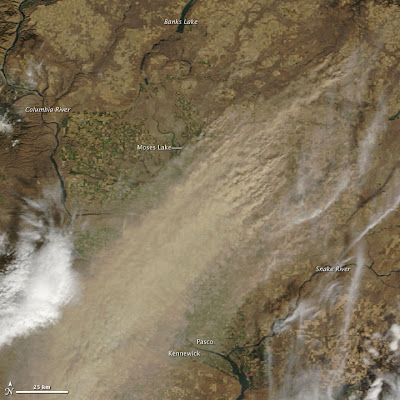
Dust Storm in eastern Washington
I saved this image from the MODUS satellite from a storm that hit eastern Washington in the early fall of 2009. In this case the dust storm was generated by winds blowing in the opposite direction than typical for dust storm events in eastern Washington. In this case the wind was from the northeast. More typically the hard prevailing dust transporting winds are from the southwest.
Strong southwest winds have been transporting sand and silt from the Columbia River Basin near Kennewick and Pasco towards the northeast for hundreds of thousands of years. The very dry basin combined with sediment deposits from the Columbia River have provided sediments for wind transport to the northeast for a long time. Silt in the rolling hills of the Palouse and areas outside of the Missoula Flood scoured land have accumulated in places hundreds of feet. These silts support a huge dry land wheat crop as well as peas and lentils in moister areas. In the storm above, some of the silt is being returned to the basin but also shows that silt can be blown up onto the Horse Heaven Hills south and west of Kennewick. Indeed there is a layer of wind blown silt covering much of the Horse Heavens.
Piles of wind deposited silt in the Palouse of eastern Washington
Silt in road cut shown above


No comments:
Post a Comment