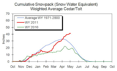
Cliff Mass posted the above plot regarding the snow pack in Seattle's water supply watershed. He notes how rapidly the snow pack recovered to average and beyond this spring with huge accumulations in March and April. In this plot the snow water equivalent (SWE) reached average at the beginning of April after very little net accumulation in January and February. The graph shows that snow has continued to accumulate throughout April when more typically it starts to melt. The current SWE is well over the 10 inches more than average. Very unlikely that Seattle will have water restrictions this year
As Mr. Mass is Seattle centric and I am Bellingham centric here is the Wells Creek station which drains to the Nooksack River in Whatcom County.
The Wells Creek SWE has followed a bit different pattern than the Cedar/Tolt snow pack in that the SWE never really lagged below average, but it followed a similar pattern from March onward with rapid accumulation that has continued even when on average the snow pack begins to decline. At present Wells Creek has a SWE 25 inches above average.
The Middle Fork Nooksack station is located nearly 1,000 feet higher than the Wells Creek station.
This plot includes only this 2011 (blue) and 2010 (green) as the plotter did not have the average data. The Middle Fork site has a whopping 85 inches of SWE nearly 30 inches more water than last year. Melt began late last year as well so the peaks may coincide. However, snow levels in the North Cascades have continued to dip down to 4,000 feet so more accumulation of SWE may be expected over the next couple of days. Although an average SWE plot was not available for the Middle Fork Nooksack, this is the highest SWE at the Middle Fork Station since 2003 (earliest available data).
I did one more plot for Marten Ridge near the Mount Baker Ski area.
Precipitation has been about the same as last year, but lots more came as snow with an accumulated SWE 35 inches more than last year.
How the melt pattern evolves will be interesting for river levels if there is a sudden warm up in late May or early June after continued cool weather. While snow pack levels will be good for hydro power and water supply, there will some farmers on low lying areas along the rivers that may not be able to get crops planted. This may be a year of late spring flooding.


No comments:
Post a Comment