A couple months ago I did a channel migration zone assessment on a creek in north Whatcom County. The purpose of the project was to determine if the creek channel was migrating or potentially migrating. Knowing channel migration potential is important from a geologic risk perspective, but it is also important from a habitat perspective. Channel shifts create new habitat particularly for fish and this can be even more important when the fish in question are an endangered salmon or trout species.
I faced some difficult constraints on this project. I had one day to visit the site, and then one day to do some historic research and write a report. Said report was then submitted to the hearing examiner and then I needed to defend my conclusions in an adversarial setting in front of a hearing examiner with another expert on the other side and attorneys asking questions. Yikes!
The first thing I did was I pulled up a LiDAR image of the area. The creek channel was reasonably apparent as was the valley the creek was situated within and it looked like old channels or terraces were present. The LiDAR is a bit rough due to thick tree cover along areas of the creek. The lumpy areas in the image are forested and the trees interfere with the number of laser shots that reach the ground, particularly if the trees are thick evergreens.

Creek LiDAR image with my markup of channel migration line
Numbers are discussed below
The dark blue line is my interpretation of the channel migration line
The methodology typically utilized for delineating CMZs is to identify historic migration zones, avulsion hazard zones, erosion hazard zones and areas that are disconnected from migration. Rapp and Abbe (2003) developed a framework for delineating CMZs for Washington State Department of Transportation and Washington State Department of Ecology. Similar approaches have been utilized by Klowan (2004) and Perkins (2006) for rivers in Jefferson County , Washington
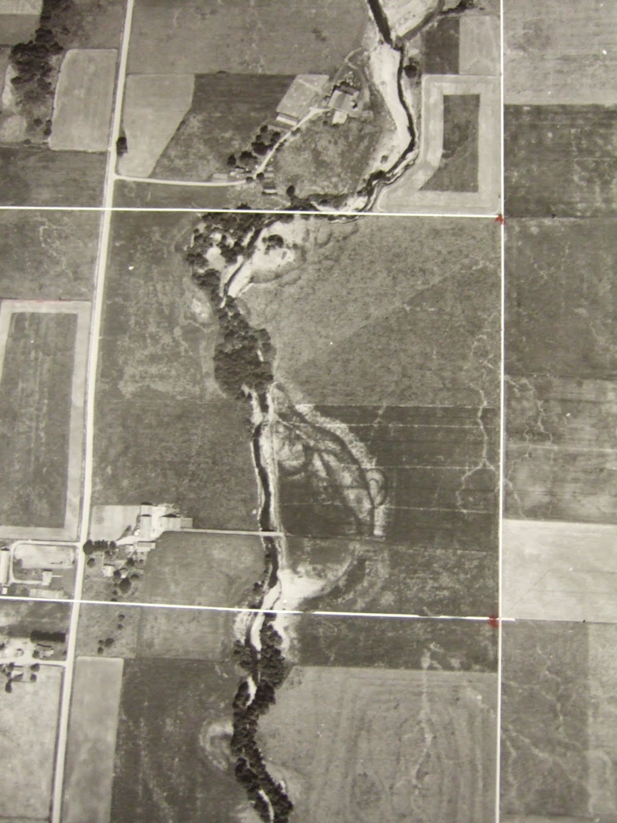
Historic migration zones can be identified using historic aerial photographs or surveys. With much of the creek tree covered seeing the creek in historic aerial photographs was a bit challenging. It is even difficult to discern the creek location in the most recent aerial photograph in the vicinity of the area I was looking. However, upstream of the subject property, historic photographs do indicate that creek

1950 aerial showing an old cut-off meander on upper right
1961 aerial - note old cut-off meander on right

1975 aerial of same area with cut-off having faded after being farmed for years

1961 aerial - note old cut-off channel to left of trees

1995 aerial - note old cut-off channel no longer as evident
So I had a LiDAR image showing that migration was certainly a possibility and had taken place in the past and I had historic aerials indicating past channel movement within the past century had taken place along the creek. I also had a county flood hazard map showing potential 100-year flood areas along the creek.
Part of a day in the field determining on the ground conditions with LiDAR, aerials and flood map in hand was the next step. It turns out this creek had a variety of channel migration features to consider. I numbered the features on the LiDAR and discussed the channel migration conditions for each location.
Area 1 (see LiDAR map above) is located upstream of the subject property but is a location where past erosion has taken place and where the creek is flowing directly into the bank at a nearly 90 degree angle. The LiDAR image indicates that a former channel was located to the west of this sharp bend. If the creek erodes through the bank this location is a potential avulsion point and the creek would follow the low ground to the west along the base of the slope to the upland area. Sure enough, after smashing through the blackberry brambles, I observed that the bank has clearly been eroded.
Area 2 would be subject to rapid erosion if an avulsion takes place in the low area upstream at Area 1. Area 2 is located along a low bank area on the northeast portion of the property. It appears that this area is subject to periodic flooding with overbank silt and fine sand deposits. However, most of this area was not flooded this past winter. Most of the recent erosion along Area 2 has been located on the opposite bank where upland slopes have been eroded, but a few spot locations of erosion are evident on the subject property in this area. It appears that this low bank is susceptible to erosion from large trees on the opposite bank falling into the creek and defecting flow against the bank.

Bank edge collapse along Area 2
Area 3 is an area of steep upland that has been undergoing recent active erosion. This area is outside of any historic or prehistoric channel area and the upland is well above flood levels but is actively being eroded as the channel migrates toward and undermines the bank area. This erosion hazard area and the resulting erosion and geotechnical setback would establish the CMZ back behind the steep slope well outside of the flood zone or ordinary high water mark.


High bank erosion. Bank consists of recessional glacial outwash sand and gravel
Area 4 is immediately downstream of the eroding high bank. This area appears to be flooded on a frequent basis and has a flood channel along the base of the high bank slope where some erosion has taken place, but the main channel is not located along the base of the high bank slope. The OHWM is located at the base of the upland slope in this area. The proposed Zone A flood zone does not include this area. The elevation of this area may not have been accurately picked up by the LiDAR.

Overbank flood channel along base of slope causes periodic erosion
Area 5 is a low bank area that is primarily brush and grass covered. A string of wetlands is located along the northwestern and western edge of this area at the base of the slope. The low spots with wetlands appear to be related to a partially filled in former channel. Flooding by the creek has deposited sediment in this area and over time has partially filled in the old channel. Area 5 is located on the outside bend in the creek. Recent erosion areas are present along parts of this bank.

Gravel bar downstream is directing the current towards the right bank

Undermined bank
Determining the potential for channel migration relies on geologic observations and interpretation and evaluation of overall stream processes taking place currently and projecting into the future. There is always a degree of uncertainty in this type of analyses. A very large significant flood event, major influx of sediment, or formation of log jams may alter conditions and cause very rapid channel migration even where little change had taken place historically. As observed on the site and in the vicinity, areas of upland that are outside of any previous channel area and that are well above the flood area are being eroded and should be considered to be within a projected channel migration area.
One final note. A lot of conditions that are current should not be considered as future conditions. Issues in particular come to mind regarding this creek: 1) a significant number of trees have been planted and maintained along the creek banks and over time some of these trees will fall into the creek diverting water against stream banks, 2) the head waters area of this stream has undergone some residential development and peak flows have been increasing, 3) beaver activity that has been greatly diminished for well over a century may increase as beavers recolonize the area.


No comments:
Post a Comment