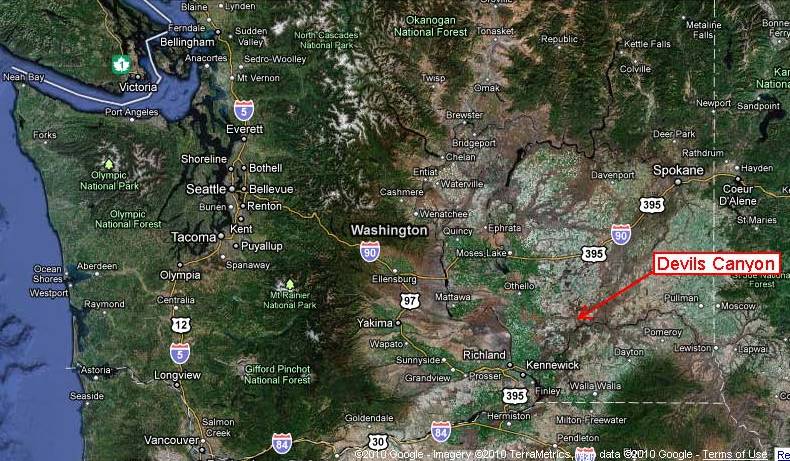
Tuesday, August 31, 2010

Indian Island, Jefferson County

Google Earth Map showing Indian Island and Marrowstone Island

I had some field work yesterday that included a slope across from Indian Island in Jefferson County. Indian Island wasn't always an island. It was formerly connected to the mainland via a sand and gravel bar. Charles Wilkes called the area Craven Peninsula when he mapped Puget Sound in 1841. A canal was carved through the spit in 1913 to shorten the distance between Oak Bay on the south and Port Townsend to the north. A ferry was operated to get from the mainland to the the island until a high bridge was constructed in 1951. A county road still angles down the slope to the old ferry landing.
Old ferry landing for Indian Island

Bridge to Indian Island.

The Island is almost entirely owned by the U.S. Navy as a weapons depot with loading facilities at the north end of the island. The entrance to the depot is located just past the bridge. The entrance area was a scene of protects during the Iraq War with as many as 37 arrests for trespass and blocking the depot entrance.

Entrance to weapons depot

The road (a state highway) continues past razor wire topped fences along the south end of the island to Marrowstone Island. The entire south end of the island is lined with county park land with great shore access including beaches and back water tidal estuaries. A number very healthy garry oaks are located between the road and Oak Bay. A rare tree and rarer still to see such large oaks in western Washington. A few are the biggest I have seen with the exception of a some in a park in Oak Harbor.

                
Oak Trees along the south shore of Indian Island

The road continues across a culvert and onto Marrowstone Island.

Tidal area between Marrowstone Island on the right and straight ahead and Indian Island on the left

Sunday, August 29, 2010

Wind and the Washington Landscape via Cliff Mass

I am wrapping up a weekend of being a bit under the weather. Lots of reading, sleeping and video watching. So here is another video that has relevance to our local landscape. Wind shapes our forests and in some places explains the types of trees we see. One reason Sitka spruce are much more common on the coast is the strength of the wood. There is a reason it was used in manufacturing of airplanes for a period of time.
What I really liked about this video is Professor Mass' comparing hurricanes with the huge storms that frequently batter our coastal areas. Anyway a nice video for you weather geeks when under the weather.

Saturday, August 28, 2010

Big Rocks in Debris Flow Clip

This may be one of the best views of really big boulders being floated in a debris flow I have ever seen. The rocks are floated because the specific gravity of the fluid becomes so high due to the presence of greater than 50% by volume of sediment in the flowing fluid. The best part of the film is about one and half minutes into the clip. 


The footage is from northern Pakistan and was via Dave's Landslide Blog. Dave had a another video suggestion that I had put up in July on Yosemite thanks to Sam Crawford.
Debris flows a big risk to alluvial fan areas in Washington State and numerous debris flows have routinely damaged property whenever we get big rain falls.

Friday, August 27, 2010

Paper Plats and City Trails in Port Townsend

Madison Street change over from street to trail, Port Townsend.

During early settlement of Washington a pattern of land claims was followed that still has impacts today. The approach was to file a homestead claim and then follow up with platting an entire community on said land so that "late" arrivals would have a home site. It was a profitable scheme if you could convince buyers that your plat was the place to be.
The plats often had no regard to land with street routes going over cliffs or into water. Many of the communities never developed, but others did move forward. Port Townsend on the northeast corner of the Olympic Peninsula was ideally located for early settlement as it was just inside the Puget Sound inlet from the more open Strait of Juan de Fuca. However, significant portions of the city was platted in a manner without much regard to the slopes and is a good example of street and lots located on cliffs or unbuilable slopes. The number of streets is also much more than is needed. Lots have been created on some of these old streets, but of late Port Townsend has had a policy keeping those streets for open space and trail routes and in recent years has actively marked the old platted streets as city trails likely in part to prevent encroachment by neighboring property owners. The approach has left lots of open space within the urban portions of the city where lots area as narrow as 30 feet (many homes use two lots in those areas) and provides nice alternative walking routes.

Thursday, August 26, 2010

Nice Responses to Posts

I had a couple of nice blog related interactions. Earlier this summer I posted about the warm water in Dabob Bay HERE. I received a card in the mail with a painting of the exact rocks I used to swim from painted by Bainbridge Island artist Georgia Vincent.
View very similar to the Georgia Vincent painting.

Earlier in the week Kevin Pouge of Whitman College sent me an email with his Geology Field Trip Paper: Folds, floods, and fine wine: Geologic influences on terroir of the Columbia Basin (The Geological Society Field Guide 15, 2009). It really is a fun paper and I am finding I am starting to better remember Washington wines now by the geology they grew on.
Portion of Wallula Winery taking advantage of the geology.
Winery is on the west side of Wallula Gap where the Columbia River cuts through the Horse Heaven Hills

Wednesday, August 25, 2010

Notes from the Metaline Formation Lead/Zinc District

Easy walking in the Selkirk Range

I was doing some mineral assessment work in northeast Washington State earlier this summer. The open woodlands makes for easy going in the field compared to the brush wresting I engage in on the west side of the Cascades. However, drinking water is a bit bigger of an issue when the temperatures are in the upper 90s like the day I took this picture in the southern part of the Selkirk Range.

The northern half of Washington State is nearly entirely mountainous from the Northwest Cascades and North Cascades in the west to the Selkirk Range in the east. Except for a few of the valleys and highest peaks these ranges are mostly forested. Continental glacial ice covered all of these ranges such that the drainages have been defined by deep glacial carved valleys. The part of the Selkirk Range I was working in was fairly gentle with lots of exposed rock from the glacial scraping and open forest. To the north and east the mountains get higher and the forest starts taking on a decided wet aspect that looks remarkably like western Washington.
The rocks I was inspecting had unfortunately been given very similar names: the Maitlen Formation and the Metaline Formation. The Maitlen includes Early Cambrian (520 million years) limestone and dolomite. The Metaline Formation is Middle Cambrian to Middle Ordovician (510 to 470 million year) and includes bedded limestone. Both have been metamorphosed in the area I was working such that I really could not distinguish one from the other without relying on other unit relationships.

Maitlen Limestone

Gypsy Quartzite
Stoffel and others (1991) interpret both of these units as well as associated formations of similar age to have been deposited within a passive margin basin adjacent to the former edge of North America. The formations were subsequently deformed and faulted within the Kootenay Arc during the late Triassic (210 million years). Morton (1992) has interpreted the margin deposits of the Metaline and overlying Ledbetter Formation to have been deposited along a more tectonically active North American margin with faulting and laterally discontinuous depositional environments during deposition and compaction of the Metaline and Ledbetter Formations.
The Metaline Formation has been a rich mining unit in the history of northwest Washington. The primary mining that has been done in the area has been lead and zinc deposits. The mineralization of the Metaline Formation is considered to be a combination of Mississippi Valley type and Irish type ore deposits (Morton (1992). These types of deposits are formed by conate water (water that was present at the time of deposition) within the formation being pushed out of the formation during and after deposition as the sediment compressed. As water moves through the deposit, sources of zinc and lead are leached and deposited in concentrated areas due to changing water chemistry as the water moves through the formation. Minerals associated with the ores in Mississippi Valley type and Irish type lead-zinc deposits are typically sphalerite, galena and pyrite with other less common sulphite minerals. The largest open pit mine in the state is located in the Selkirk Range is a now abandoned lead/zinc mine. A number of lead/zinc mines are scattered throughout the Metaline Formation. Perhaps the best exposures are within the deep narrow gorge of the Pend Orelle River (pronounced pond-or-ay) just south of the Canadian border.

Mine workings north of Metaline Falls within the Metaline Formation
Drowned mine entrance along reservoir shore
Mineralized zones within the Metaline Formation
Exposure of Ledbetter Formation, likely source of lead and zinc
The lovely Peewee Falls across the Ledbetter Formation

Monday, August 23, 2010

A Few Odd Observations while Heading Home

As a scientist I often develop theories as to why the land looks the way it does. On a recent trip I made a few observations that had me a bit mystified. The first was a camp ground in an out of the way place in eastern Washington called Deadman Gulch in northern Garfield County. The camp ground was packed with trailers. I was completely baffled as to why the camp ground was full. There is little reason to be out in this area in the summer unless your working and even the places along the Snake River I had passed earlier in the day were devoid of people. About ten minutes later along the ridge above the Pataha Valley I observed scattered construction sites with lots of equipment and I realized that the campground was full of workers campers that had come to the area to set up sites for wind turbines. The wind farm is slated to produce 348 megawatts and the power will be owned by Puget Sound Energy. So those of you that buy Green Energy from Puget Sound Energy helped make a remote campground operator in Deadman Gulch very happy.

Construction Management site for Lower Snake Wind Farm

The second mystery was a concrete paved county road. Most roads in the area I was driving are unpaved; hence, it was bit of surprise when I turned onto Lower Monumental Road in Walla Walla County and found myself driving on concrete road.


My initial guess was that it was some sort of experimental road. Then I thought that maybe it was paved with concrete when Lower Monumental Dam was built. But when I reached a fork in the road and I turned onto the Lower Monumental Road I left the concrete pavement which continued on Sheffler Road. Sheffler Road accesses the Snake River at a Port of Walla Walla facility for grain shipment. The road gets a lot of heavy truck traffic and concrete will hold up better.

My third mystery was while looking for access roads up to the Saddle Mountains in central Washington I came across this canal that has done a great job of gathering tumbleweeds. The canal connects to an active canal that directs irrigation water to the Wahluke Slope. I am not sure if the canal is used anymore, but it has been used to periodically send water onto the Wahluke Wildlife Refuge managed by the United States Fish and Wildlife to enhance bird habitat for hunting. The time of year that it wouold most likely be used would be in fall prior to the arrival of over wintering birds. The area is now part of the Hanford Reach National Wilderness Area.
   

Friday, August 20, 2010

Eastern Washington Wheat Crop

Winter wheat southeast of Connell. The ridge in the distance is Rattlesnake Ridge.

The New york Times had an article on wheat farming in Colorado in light of the drought impacting Russian wheat HERE.  The drought in Russia along with problems in India and Australia have pushed prices upward. Hence, wheat farmers will be getting a good price. And the question of planting more wheat is being raised.
Eastern Washington has had a huge bumper crop this year. A cool moist spring gave the winter wheat a big boost and the rare combination of a large crop combined with high prices. There is some variability in the price depending on protein content. For some farmers the protein content will be lower due to the high yields dependening on the fertility of the soil and how much fertilizer was applied in the fall.
New York Times' Kirk Johnson posted a blog on the concerns about growing wheat on the plains HERE. And Timothy Eagan wrote about the dust bowl and wheat/sod busting in The Worst Hard Times. This got me thinking about comparing the climate in eastern Washington with that in southeast Colorado where the NYT article was centered.
For Washington State I picked Connell as it is located on the western driest part of The Palouse (as well as being near some family wheat growers). The NYT article centered on Springfield, CO, but the weather record in Lamar in a similar setting  40 miles to the north is more complete. Connell's average rainfall is 9.75 inches compared with Lamar at 15.24 inches. But it's when the rain falls that makes all the difference as can be seen in the following two charts:

Comparison of rainfall by month between Lamar, CO and Connell, WA
Note that the difference on the precipitation scales.

Lamar gets more rain, but the bulk of the rain takes place in the summer. Connell's scant rain falls in the winter and into early spring. Rainfall (and snow) during the cold and cool weather of winter and spring stays in the soil and is used by the wheat as it begins growing as the weather warms. Dryland wheat farmers in eastern Washington plant winter wheat. They plant the seeds in the fall to take advantage of the winter precipitation. Hence, even though Lamar may get more rain, the timing of that rain is not as favorable for wheat as the lower rain fall in Connell.
I also looked for extreme dry periods. For Washington State I looked at Pullman as its records goes further back than Connell. Pullman's average rain is a bit more than Lamar 18.98 inches compared to 15.24 inches. Pullman's driest year was 11.81 inches in 1944 and Lamar's 7.67 in 1937. One thing was clear looking at the Lamar data; the Dust Bowl and Depression era was very dry with all years below average and most more than a third below average. Lamar has not had a sub 10 inch year since 1981. Pullman during the same period had fairly average rainfall with the Depression era rainfall not much different than the range over the past decade.


Thursday, August 19, 2010

Almota, Washington 1882 and 2010

Part of my work as a geologist sometimes involves historic research. The Washington State University Library, Tacoma Public Library and Seattle Public Library have been an enourmous help over the years. Doing some research associated with work this moring, I stumbled across this historic image that relates to the post I put up yesterday.
Almota, 1882

Almota, 2010

As can be sen in the 1882 image, Almota was site of commerce with the steam boat coming up the river. These steam boats were very shallow draft to get past the various shallows in the river. Almota is still used as a shipping location for wheat today. State Highway 194 provides accesses from the north and the site serves as a wheat shipping center for farms west of Pullam and south of Colfax. The original town site was flooded by the construction of Little Goose Dam in the 1960s. The shipping terminal is constructed on a fill bench located approximately where the small town was once located. Besides river access, this grain terminal also has access to a rail line that follows the north shore of the river. Almota is located at the northernmost reach of the Snake River. The name is derived from the Nez Perce Indians meaning torchlight or moon light fishing. 


Wednesday, August 18, 2010

Getting the Wheat to the River

The Palouse has been a wheat growing area since the late 1800s. The silt loess soils of the Palouse are very fertile, hold soil moisture well and are blanketed with dry land wheat. That is the wheat is grown without irrigation. Rain fall amounts in the western Palouse dip below 10 inches per year, but most of the precipitation falls in the late fall through early spring during the cold season and thus is soaked into the soil and available for winter wheat.


The Snake River cuts through the middle of the Palouse wheat lands. From the beginning of agriculture in this region, transportation to market has been nearly as important as growing the crop itself. Transport via boat was quickly established with a fleet of steam boats navigating up and down the lower Snake River to the Columbia River and Portland. However, the lower Snake River is entrenched into a very steep and deep canyon for most of its length. Hence, even though the river might be a just a few miles away, access to the river can be challenging.
Hauling heavy wheat loads down steep grades using teams of horses or steers with the brakes applied the entire descent was long and dangerous. Even today the roads used to access the canyon are steep and low gear and brakes need to be applied even in a light passenger car. An approach to avoid the steep dangerous grades was building grain slides. These involved wooden tubes that funneled the wheat to the river below. The initial design worked, but the heat generated toasted the wheat black. With baffles and vents the system worked better. Coordination was required however with loading the slides at the top and bagging the wheat below. A tram system was built in the Mayfield area. Bill Gulick included a fictional description uses of the tram system in his historic novel Roll on Columbia and reports that at least five grain slides were operated along the river.
While making a drive down to the canyon bottom in the eastern Palouse, I noted a road called Tramway Road that skirted along the upper edge of the canyon and decided it would be worth the minor added distance on the route to the canyon bottom. The route led to great views of the canyon and had the added surprise of the remnants of an old tramway used for hauling wheat to the river.

Top of old tramway with river below
Trace of tramway route down the slope. The canyon is 1,600 feet deep. 

The lower Snake River is still heavily used for grain transport. In fact with the lower four dams river transport can be done with large boats and over a longer period of time. Trucks and development of paved roads has eased access to the river and with bulk transport the old wheat slides and tramways have been long out of use.
I should add a brief note on the geology of the canyon. The horizontal bands on the slopes are primarily various basalt lava flows of the Columbia River basalt group. However, the base of the canyon at this location has eroded down into the underlying ancient continental margin.

Monday, August 16, 2010

Geology Inspired Wine - Its all in the Dirt

I was given this wine cork last week. It was from a bottle produced by Glacial Lake Missoula Wine Company http://glmwine.com/. I have not tried the wine but appreciated that those drinking it thought of me.
The Missoula Flood deposits underlie the majority of vineyards in eastern Washington and the flood has become a big part of the story for the eastern Washington wine growing region. Any vineyards below an elevation of 1,250 feet are likely growing from Missoula Flood deposits. This winery appreciates the geology as all the vineyards they use as from the Yakima Valley. The winery itself is located in Blaine, Washington in the northwest corner of the state well outside the deluge area. Blaine was under 5,000 feet of ice when the deluge events took place.

Saturday, August 14, 2010

Eureka Fire


The Eureka Fire in burned through part of northwest Walla Walla County last week. The fire burned more than 20,000 acres of mostly grass land. The north perimeter is defined by Lower Monumental Road. Fires in eastern Washington's scrub steppe burn large areas fast especially if there is any wind. The presence of invasive cheat grass has resulted in hotter fires through the dense carpet of low grass and the fires frequently now kill sagebrush such that large areas that were formerly sagebrush covered are now now without sage brush particularly in the more dry areas that are marginal for sagebrush survival.

Earlier this summer I took this picture of a grass fire just east of the Dalles, Oregon that burned several hundred acres in a couple of hours. I caught the fire just as it entered a dry riparian area and went from crawling along the ground to huge flames in seconds.

Friday, August 13, 2010

Devil's Canyon south of Kahlotus

Devil's Canyon

Location on Google Earth

Devil’s Canyon cuts a gash across the wheat fields from Kahlotus to the Snake River at Lower Monumental Dam. This is one of many flood way channels carved during the Missoula Floods. The satellite image from Google Earth shows the multiple channels carved through eastern Washington from the floods. The flood waters entered eastern Washington from the east when the glacial dam blocking the Clark Fork River collapsed. The collapsed led to draining of Glacial Lake Missoula. The lake was a big lake – 2,100 feet deep and containing 250 cubic miles of water all of which drained out and across eastern Washington in three days or less. The flood initially entered Glacial Lake Columbia which rapidly filled and over topped its valley sending flood water across multiple channels.

Arrows mark flood water routes across eastern Washington.

One of the largest flood routes sent water southeast from Spokane into the ancestral Palouse River Valley. The volume of water far exceeded the capacity of the entire valley and water spilled out of the top of the valley at multiple locations. One of these over spill routes became the new route of the Palouse River. The old river valley flowed though what is now Washtucna Coulee. Another over topping location is just south of the Town of Kahlotus into Devil’s Canyon.
Devil's canyon cutting across Palouse fields.
I haven't figured out the mosaic of images cobbled together of the wheat fields. Its a mix of every season except the gold harvest times.

Topography. The north-northeast trending ridges are reflective of the wind direction that deposited the loess of the Palouse over the area both before and continuing after the great flood. 

Devil’s Canyon cuts a straight, south-southeast trending, 600-foot deep gash through the Palouse wheat lands from the lip of the Washtucna Coulee to the Snake River. The straightness of the gash is reflective of major structural joints in the basalt bedrock and similar straight gashes are located to the east including the current Palouse River Canyon.

Most of the Devil’s Canyon walls consist of bedrock from another flood – the flood basalts of the Columbia River Basalt Group. The bulk of the basalt in the canyon is part of the Wanapum Basalts. These basalts were erupted from vents 60 to 100 miles east and southeast of the site and covered vast areas at the time of eruption approximately 15 million years ago. Younger basalts are present in the canyon as well and are part of the Saddle Mountain Basalts. These younger flows flowed down through the ancestral Snake River and adjoining canyons that had been cut into the older basalts. The flows exposed in Devil’s Canyon are on the order of 10 million years old, but a flow as young as 6 million years old is located to the south across the Snake River.

More often than not the columns that sometimes develop as the lava cools are vertical. In this case the columns are at chaotic angels reflective of the cooling direction. The picture is a view of the younger intercanyon flows of the Pomona, Esquatzel and Elephant Mountain Members of the Saddle Mountain Basalts filling an old canyon against the wall of the Frenchman Springs Member of the older Wanapum Basalts.
Wanapum basalt is on the left with younger basalt of the Saddle Mountain basalts filling in the ancient canyon.

The canyon provides a route for wheat growers to transport wheat down to the Snake River. The Snake carves a deep canyon across the southern Palouse and routes down to the river have long been a challenge for wheat producers. The Devil’s Canyon route is steep but there are no other roads down to the river for many miles east or west. A rail line formerly followed the canyon as well but the tracks have since been removed in favor of trucking and barge shipment.
Grain storage and loading facility on Snake River

One final note: across the river from the grain loading facility, huge gravel deposits cover part of the south side of the Snake Canyon wall up to 350 feet above the river. These gravels are from gravel transported into the Snake River from the Palouse River Missoula Flood route.

Saturday, August 7, 2010

Geology In a Traffic Jam

I noted the makeup of the concrete pavement on I-5 while in slow moving traffic. A nice matrix supported conglomerate with rounded pebbles. I will say that my fellow passengers thought me a bit odd snapping a picture of the pavement, but pavement is part of the Washington Landscape and it is part of the landscape many of us interact with everyday. This particular patch of concrete landscape is 50 years old. Concrete is more expensive than asphalt and slower to lay down as pavement, but it lasts a much longer time.


Concrete requires mining. Two types of mines are required: lime for the cement and sand and gravel for the aggregate mixed into the cement. Washington State has extensive limestone deposits in northeast Washington. Small lime deposits in western Washington have been mostly if not completely mined out. The town of Concrete built up to process limestone from nearby mines but that industry is no longer active as the mines were exhausted. In Whatcom County extensive limestone mining took place in the early 1900s north of Kendal and Maple Falls. The extent of the ruins and the number of people that once lived in the area for the mining is surprising. Limestone mining took place on the west side of San Juan Island. One of the mines on San Juan Island is now a state park, Lime Kiln Point State Park. Much of the lime for cement in Washington is now imported via rail and ship with some coming into Puget Sound via barge from Texada Island between mainland British Columbia and Vancouver Island.

Sand and gravel for concrete is certainly more common, but quality considerations make some sand and gravel deposits significantly more valuable than others. For concrete, roundedness is a good thing for most concrete as it helps for mixing. The hardness and strength of the pebbles is important as well. Soft rock pebbles would ware down too fast. And certain rock types do not react well with cement and thus can not be used. Too much andesite is generally not good.
Besides quality the value of deposit is based on accessibility and proximity to markets. Being next to good roads and near cities is a big bonus. Water access is useful as well. Trucking gravel is expensive but barging is cheaper. This issues has caused significant debate for the sources of gravel for expanding the Seattle-Tacoma airport with mining of Murray Island being one of the proposed sources. Hence the other major factors are environmental impacts and ease of mining and processing.

Eric Cheney my UW economic geology professor noted that though aggregate mining may not appeal as much as gold, but a good aggregate deposit can be very valuable not only to the deposit owner but to the engineers that utilize the product. As it turns out in my career I have spent a lot more time evaluating aggregate and quarry rock than other economic deposits. I sometimes describe my job as getting paid to give people bad news, but when it comes to aggregate valuation, I have had the pleasure of delivering good news on numerous occasions. A high quality deposit in the right location and with the right market conditions can be very valuable.

Thursday, August 5, 2010

Fire Season

August 4, 2010 sunset at Alki Point, Seattle.

Since Sunday there has been a noticeable reddish/orangish hue to the sky from smoke once the fog burned off. Cliff Mass has a couple of nice posts regarding the smoke HERE and HERE. Timothy Egan also wrote up a nice piece on fires in the northwest HERE.

Despite a fairly cool spring and summer it has been dry in Washington. The fire season in Washington begins as the grasses in eastern Washington dry and then slowly but surely the forests begin to dry as well.First the drier pine forests east of the Cascade crest but given the right conditions even the forests of western Washington can dry out enough to be susceptible to fire. Even the very wet western side of the Olympic Peninsula has had big fires may years ago. Huge Douglas firs near Quinalt are the result of a fire over 500 years ago that allowed the firs to get established there. Fires are and have always been a significant part of landscape in Washington.

Wednesday, August 4, 2010

Dead cedars at Debris Flow Deposition Area

I had a small project up the Nooksack River Valley northeast of Bellingham this morning. On the way I glanced up the stream the sent a debris flow over the state highway in January 2009 closing the highway. I previously did a post HERE on this debris flow. One consequence of that event is that numerous trees in the debris flow deposition area have died. Western red cedar in particular does not like having its lower truck buried and I have observed dead cedars in older debris flow deposition areas. I don't have a perfect match photo but the same trees still alive can be seen in the January 2009 picture.

August 2010 view of dead trees along debris flow deposition area

January 2009 shortly after debris flow with trees still living.

The debris flow took place on the Mount Baker Highway just past the Truck Road intersection.

Tuesday, August 3, 2010

Lopez Island and Juniperus maritima

I had a job on Decatur Island today. Someone had to do it.
I walked on the Anacortes to Lopez Ferry and had some time at the Lopez landing waiting my pickup for the next leg of my journey.
So I poked around at the well exposed conglomerates near the ferry landing. The conglomerates at the location are considered by Brown (2014) to be part of a very old part of the Nanaimo Formation.

Pebble conglomerate of that has been interpreted to be Nanaimo Formation (Brown, 2014).

But my big discovery was this tree growing out of the ancient sea-floor rocks.

A close examine of its foliage revealed it was a Juniperus maritima along with fruits.


Juniperus maritima are very uncommon in western Washington. There is a stand of them on the west shore of Orcas Island and along West Sound on Orcas. There is reportedly an isolated populations on the Olympic Peninsula but I have yet to come across any in my ventures on the Olympic Peninsula.

The Lopez Ferry landing area had some other nice surprises that will have to wait another day.