Saturday, September 14, 2013

Terminal Coal Reading

Back in the early 2000s EFSEC reviewed a proposed natural gas power plant in Sumas, Washington  sumas-energy-2-efsec-and-corn-field. It was a huge local issue and after a long review process EFSEC announced its determination before an overflow crowd of citizens. All very dramatic. The determination was to deny the project permit. A rare determination and in fact the only time EFSEC ever flat out denied a permit.

What followed was much less dramatic. The power plant proponent reworked their scheme and reapplied with an application that met every objection that caused he denial. EFSEC then said yes and then..............the power plant was never built.

In regards to the coal terminal proposals, energy market followers are strongly suggesting that the proposed coal export terminals may follow a rather non dramatic path of studies not being completed and no big determinations. nytimes.com/us-coal-companies-scale-back-export-goals

But for silliness, one does have to wonder just what words the Lummi Nation needs to use to be understood by the lawyers working with the Army Corps of Engineers bellinghamherald/feds-still-see-wiggle-room

Wednesday, September 11, 2013

Glacial Retreat, Landslides, and River Flood Impacts

Hunting Landslides with Landsat


NASA put up a nice before and after image (see above) of a landslide along a glacial margin in Alaska earthobservatory.nasa.gov. This slide was caught on seismic monitors and the approach of identifying large slides has been followed by Dave Petley at the landslideblog.

A similar landslide event took place this spring along a very steep slope on the west side of Mount Baker mbvrc/update-nooksack-debris-flow-initiated-by-landslide-not-outburst-flood/.

Essentially the glacier erodes the toe of the steep mountain slopes, but as long as the ice remains the steep slope is buttressed by the ice. When the glacial ice retreats the steep slopes no longer have the mass of ice buttressing the slope and will be subject to failures. The sediment slug added to the stream or river then has to be 'processed' through the river system. The big stuff takes some time.

During the late May 2013 event on Mount Baker turbidity gauges along the river recorded very high readings as the fine sediment passed downstream. The silt and clay ultimately gets deposited in Nooksack River delta and Bellingham Bay.

A very muddy Nooksack River in early June 2013

Many of the larger glaciers that extend down river valleys off of the Cascade Range volcanoes have retreated significantly the past several decades leaving lots of unsupported steep slopes. Hence, sediment loads to river systems fed by these streams and rivers may be receiving a significant increase in episodic slugs of sediment.

Tuesday, September 10, 2013

Turtleback Looks Like a Turtle

While pulling out of Friday Harbor on San Juan Island, I had one of those "now I get it" moments.

Turtleback Mountain, Orcas Island

Yes, Turtleback does look like a turtle - particularly when viewed from the San Juan Islands most populous location at Friday Harbor. A big part of Turtleback is owned by San Juan Land Trust and there are public trails with great views and some great prairie ecology. The site also has what I describe as the rarest forest in western Washington: rarest-forest-in-western-Washington. Turtleback lends its name to the oldest rocks in the San Juans - the Turtleback Complex. The complex consists primarily a mix of intrusive rocks that have been  interpreted to be the core of a volcanic island arc. Where exactly that island arc originally came from may not be entirely solvable. But the Turtleback is one of several accreted terrains in the San Juans.

Sunday, September 8, 2013

Some Central Washington Geology Stops/Notes

A friend is heading over to Sun Lakes and up to Kettle Falls and wanted a few geology visit tips so I assembled a few past posts that may be along their route and thought Why not just post it on the blog.

1) This first site is on the east side of the Columbia River just off Interstate 90. You can see a fair bit of palagonite just zooming along the road especially on west bound I90 portion of the freeway west of the Columbia.
http://washingtonlandscape.blogspot.com/2013/01/giant-columns-and-palagonite.html

2) The road from Brewster to Grand Coulee is one of my favorites. There is a great wide turnout to view the Columbia/Okanogan Rivers junction, ice age terraces and basalt injections.
http://washingtonlandscape.blogspot.com/2012/07/basalt-injections-near-brewster.html

3) Any drive up onto the Waterville Plateau is a great geology adventure. This route up McNeil Canyon Road is a great spot to see erractic boulders scattered across the landscape. 
http://washingtonlandscape.blogspot.com/2012/04/field-of-erratics.html

4) The highway southeast of Wenatchee has a pull out where great giant ripples from one of the later ice age floods flowed.
http://washingtonlandscape.blogspot.com/2012/02/more-on-giant-ripples-and-big-floods.html
http://washingtonlandscape.blogspot.com/2012/02/giant-ripples.html

5) This site is perhaps one of my favorite geology locations in all of Washington: back to back unconformities with the lower one being a spot where you can feel ancient soil (deeply weathered granitic rock) at the top of the lower unit just below the Columbia River Basalt
http://washingtonlandscape.blogspot.com/2011/12/moment-in-deep-time-back-to-back.html

6) I have stopped at this site three times and always had the entire place to myself. Great view of the dam and glacial striations at your feet and views of old glacial lake terraces
http://washingtonlandscape.blogspot.com/2011/12/crown-point-state-park-grand-coulee-dam.html

7) A bit subtle but the high buttes near Creston are explained and there is a road exposure of the older rocks 
http://washingtonlandscape.blogspot.com/2011/10/windows-and-islands-in-basalt-near.html

8) This is a site I want to go back to with ample time - I want to measure a few of this huge erratics
http://washingtonlandscape.blogspot.com/2011/08/glacial-erratics-near-grand-coulee-dam.html

Alas I have very little north of the Columbia. In part it is because the geology is very complex, some I can not share, and it is an area I do not frequent nearly often enough. 

Friday, September 6, 2013

Debris Flood Report from Imus Creek, Stehekin

David Tucker forwarded me a couple of pictures from Stehekin in the central North Cascades that were sent to him by Jon Riedel of the North Cascades National Park. The email came with a "Post This". Thanks David and Jon. The pictures indicate that the flood and/or debris flood came down Imus Creek just behind the small town at the northwest end of Lake Chelan. Apparently the North Cascades Pass road has also been closed for the second time this summer due to debris flooding. 

The storm event that is winding down (2:00 pm, Sept. 6, 2013) was/is a rather unusual event. Very warm and mild with lots of rain. The total rain fall numbers around the state were impressive, but the more critical aspect of this event was the rain came in the form of intense down pours associated with thunderstorms. This storm had the weather folks pretty excited as it was unusual as evidenced by Cliff Mass putting up multiple posts cliffmass.blogspot before during and as it winds down. 


For geologists, these types of events are important. It is these intense rainfall events that shape our landscape particularly in eastern and central Washington State. In the remote mountain areas it is hard to know what the total rainfalls from these events are and for that matter what the return frequency is for that kind of precipitation. Jon reported 1.3 inches of rain at Stehekin in 3 hours.

The images are a reminder that geo hazard folks need to think about unusual weather events when assessing hazards; in central Washington this is particularly true. Based on the appearance if the shed, I suspect this is rather a rare event. 

Imus Creek is a fairly small watershed. The creek is only about two miles long, but has over 4,000 feet of vertical relief and lots of bare rock exposure. High flows in the creek are mostly due to snow melt, but this storm would have generated a very different hydrologic event than the more typical yearly high water events. 

It will be interesting to see what else comes in from various folks out on the landscape after this storm system. 

Wednesday, September 4, 2013

Women Lag Behind Men......in Drowning Rates

The figure above shows average annual death rates from drowning, by sex and age group, in the United States during 1999–2010. During 1999–2010, a total of 49,762 deaths from drowning occurred in the United States, an average of 4,147 deaths per year. The average annual death rate from drowning for males (2.2 per 100,000 population) was more than three times that for females (0.7). The death rate for males was highest among those aged 1–4 years and ≥85 years (both 3.9 per 100,000 population). For females, the highest rates were among those aged 1–4 years (2.2) and <1 year (1.8).
 
When out on the various lakes, rivers and sea water of Washington State, you may want to consider drowning rates. Men drown a lot more than women in the United States.  What I found impressive with the graph is the nearly 2:1 margin for even toddlers.  Howland and others (1996) provide some further explanation regarding the rates for men. The take away is a mix of cockiness, drinking while fishing or hunting on the water and more frequent exposure to circumstances that are riskier. I confess that I have been guilty of all of the above (excepting drinking while hunting, no warm nips allowed with guns).

Tuesday, September 3, 2013

Wetland Struggles

Over the weekend a couple of wetland struggles were making the news and social media rounds. The first was regarding a forested wetland at Panghorn Bog east of Lynden that I had previously posted on after a State Court of Appeals ruling (wetlands-and-farms-one-example). The farm had cleared the forest and drained the wetland without permits and has yet to act on restoration despite the court ruling. Now the Environmental Protection Agency has sued the farm to repair the damaged wetland (EPA-sues-Lynden-farm-over-land-clearing). There is no discussion in the article regarding downstream impacts to other farmers having larger volumes of water flowing through the down stream and ditch system. 

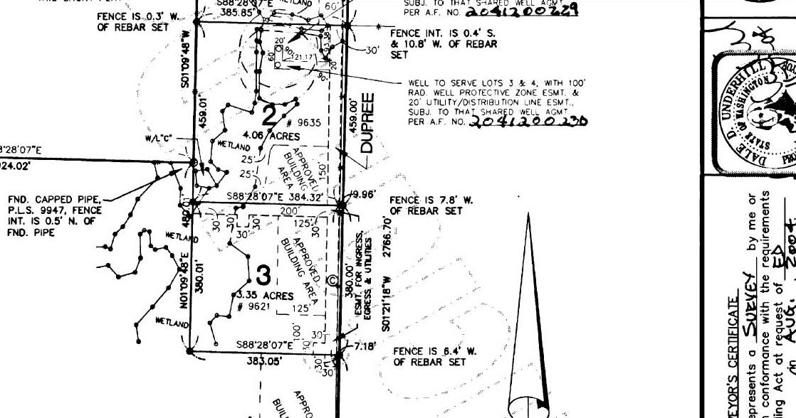
The other wetland struggle, this time west of Lynden and east of Blaine, is being circulated in this Freedom Foundation Video. I was alerted to the video via a Facebook post by Sam. There is a bit more to this story than the video suggests. Mr. Remenar's property is Lot 3 of H Street Meadows. The lot is part of a short plat (small subdivision of land). During the division of land, wetlands on the site were delineated and building areas on each of the new lots were designated. The plat map recorded with the Whatcom County Auditor (Auditor File # 2041200228) contains the following statements:

Jurisdictional wetlands and associated buffers occur throughout this property. A partial wetland delineation was conducted in order to identify building areas on each lot as depicted on the mylar. No development or maintenance activities shall take place outside the approved building areas without further critical areas review. Development and maintenance activities include but are not limited to the following: construction, clearing, grading filling landscaping, mowing, burning, and chemical maintenance of plants.

Mr. Remenar stated in the video he was unaware of wetlands on his property. I have no reason to doubt his statement, but the lot his home is built on has the wetlands designated and on file with the County Auditor with the conditions as shown above, and the excavation of the pond as well as other land clearing and vegetation management (mowing) within the wetland and wetland buffer is not consistent with the conditions placed on the lot at the time the lot was created.

Plat showing wetlands on Lot 3

2009 aerial (USGS) Wetland line derived from plat map. Conditions on the plat regarding wetlands apply to the portion of the property west of the blue dashed line

20011 (Google Earth) showing pond well within wetland boundary

The conditions on the lot as recorded with the County Auditor do not prohibit work being done within the wetland or wetland buffer, but does require a critical areas (in this case wetland) review. This sort of unpermitted thing happens and presents a headache for all involved. Perhaps a pond is a perfectly fine addition to this wetland area. But without a review and some thought it might cause harm to the wetland system. This is the headwaters area of a fairly large stream system that does have some problems with water quality. Downstream of this area are forested wetlands with beavers.

How to implement and carry out wetland regulations is not an easy business - a very tough question for local governments and probably a worthwhile question to periodically ask, Is there a better way?

Federal law requires wetland protections and have been around for a long time. States manage wetlands consistent with federal law by a variety of approaches. Washington State brings a lot of wetland regulation down to a local level as a requirement for counties and cities under the growth management act. This puts a lot of pressure on local electeds and creates a lot of misperceptions regarding wetland regulation. In the social media context, I was blamed by one commenter for the rules restricting the pond construction (I was on the Whatcom County Council for 8 years). However, the rules that applied to this plat and lot were passed in 1997 - before I was on the council and obviously the enforcement is taking place without any help from me.

I do not do wetland consulting work other than rare instances when there are some geology questions. However, I have worked on projects where clients have done work within geology hazard zones on their property and have received letters from the local government - always a tough issue, but in a way much easier as with geology hazards there is usually a great deal more deference given to the geologist. With wetlands, the fixes have to be consistent with federal law and there not as much flexibility.

Vast swaths of Whatcom County are underlain by glacial marine drift deposits with low permeability and hence vast areas have wetland issues. As such there will be far more inadvertent as well as purposeful violations of wetlands codes versus geology hazard regulations.