Monday, August 16, 2010

Geology Inspired Wine - Its all in the Dirt

I was given this wine cork last week. It was from a bottle produced by Glacial Lake Missoula Wine Company http://glmwine.com/. I have not tried the wine but appreciated that those drinking it thought of me.
The Missoula Flood deposits underlie the majority of vineyards in eastern Washington and the flood has become a big part of the story for the eastern Washington wine growing region. Any vineyards below an elevation of 1,250 feet are likely growing from Missoula Flood deposits. This winery appreciates the geology as all the vineyards they use as from the Yakima Valley. The winery itself is located in Blaine, Washington in the northwest corner of the state well outside the deluge area. Blaine was under 5,000 feet of ice when the deluge events took place.

Saturday, August 14, 2010

Eureka Fire


The Eureka Fire in burned through part of northwest Walla Walla County last week. The fire burned more than 20,000 acres of mostly grass land. The north perimeter is defined by Lower Monumental Road. Fires in eastern Washington's scrub steppe burn large areas fast especially if there is any wind. The presence of invasive cheat grass has resulted in hotter fires through the dense carpet of low grass and the fires frequently now kill sagebrush such that large areas that were formerly sagebrush covered are now now without sage brush particularly in the more dry areas that are marginal for sagebrush survival.

Earlier this summer I took this picture of a grass fire just east of the Dalles, Oregon that burned several hundred acres in a couple of hours. I caught the fire just as it entered a dry riparian area and went from crawling along the ground to huge flames in seconds.

Friday, August 13, 2010

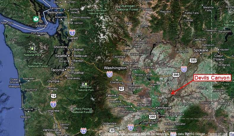
Devil's Canyon south of Kahlotus

Devil's Canyon

Location on Google Earth

Devil’s Canyon cuts a gash across the wheat fields from Kahlotus to the Snake River at Lower Monumental Dam. This is one of many flood way channels carved during the Missoula Floods. The satellite image from Google Earth shows the multiple channels carved through eastern Washington from the floods. The flood waters entered eastern Washington from the east when the glacial dam blocking the Clark Fork River collapsed. The collapsed led to draining of Glacial Lake Missoula. The lake was a big lake – 2,100 feet deep and containing 250 cubic miles of water all of which drained out and across eastern Washington in three days or less. The flood initially entered Glacial Lake Columbia which rapidly filled and over topped its valley sending flood water across multiple channels.

Arrows mark flood water routes across eastern Washington.

One of the largest flood routes sent water southeast from Spokane into the ancestral Palouse River Valley. The volume of water far exceeded the capacity of the entire valley and water spilled out of the top of the valley at multiple locations. One of these over spill routes became the new route of the Palouse River. The old river valley flowed though what is now Washtucna Coulee. Another over topping location is just south of the Town of Kahlotus into Devil’s Canyon.
Devil's canyon cutting across Palouse fields.
I haven't figured out the mosaic of images cobbled together of the wheat fields. Its a mix of every season except the gold harvest times.

Topography. The north-northeast trending ridges are reflective of the wind direction that deposited the loess of the Palouse over the area both before and continuing after the great flood. 

Devil’s Canyon cuts a straight, south-southeast trending, 600-foot deep gash through the Palouse wheat lands from the lip of the Washtucna Coulee to the Snake River. The straightness of the gash is reflective of major structural joints in the basalt bedrock and similar straight gashes are located to the east including the current Palouse River Canyon.

Most of the Devil’s Canyon walls consist of bedrock from another flood – the flood basalts of the Columbia River Basalt Group. The bulk of the basalt in the canyon is part of the Wanapum Basalts. These basalts were erupted from vents 60 to 100 miles east and southeast of the site and covered vast areas at the time of eruption approximately 15 million years ago. Younger basalts are present in the canyon as well and are part of the Saddle Mountain Basalts. These younger flows flowed down through the ancestral Snake River and adjoining canyons that had been cut into the older basalts. The flows exposed in Devil’s Canyon are on the order of 10 million years old, but a flow as young as 6 million years old is located to the south across the Snake River.

More often than not the columns that sometimes develop as the lava cools are vertical. In this case the columns are at chaotic angels reflective of the cooling direction. The picture is a view of the younger intercanyon flows of the Pomona, Esquatzel and Elephant Mountain Members of the Saddle Mountain Basalts filling an old canyon against the wall of the Frenchman Springs Member of the older Wanapum Basalts.
Wanapum basalt is on the left with younger basalt of the Saddle Mountain basalts filling in the ancient canyon.

The canyon provides a route for wheat growers to transport wheat down to the Snake River. The Snake carves a deep canyon across the southern Palouse and routes down to the river have long been a challenge for wheat producers. The Devil’s Canyon route is steep but there are no other roads down to the river for many miles east or west. A rail line formerly followed the canyon as well but the tracks have since been removed in favor of trucking and barge shipment.
Grain storage and loading facility on Snake River

One final note: across the river from the grain loading facility, huge gravel deposits cover part of the south side of the Snake Canyon wall up to 350 feet above the river. These gravels are from gravel transported into the Snake River from the Palouse River Missoula Flood route.

Saturday, August 7, 2010

Geology In a Traffic Jam

I noted the makeup of the concrete pavement on I-5 while in slow moving traffic. A nice matrix supported conglomerate with rounded pebbles. I will say that my fellow passengers thought me a bit odd snapping a picture of the pavement, but pavement is part of the Washington Landscape and it is part of the landscape many of us interact with everyday. This particular patch of concrete landscape is 50 years old. Concrete is more expensive than asphalt and slower to lay down as pavement, but it lasts a much longer time.


Concrete requires mining. Two types of mines are required: lime for the cement and sand and gravel for the aggregate mixed into the cement. Washington State has extensive limestone deposits in northeast Washington. Small lime deposits in western Washington have been mostly if not completely mined out. The town of Concrete built up to process limestone from nearby mines but that industry is no longer active as the mines were exhausted. In Whatcom County extensive limestone mining took place in the early 1900s north of Kendal and Maple Falls. The extent of the ruins and the number of people that once lived in the area for the mining is surprising. Limestone mining took place on the west side of San Juan Island. One of the mines on San Juan Island is now a state park, Lime Kiln Point State Park. Much of the lime for cement in Washington is now imported via rail and ship with some coming into Puget Sound via barge from Texada Island between mainland British Columbia and Vancouver Island.

Sand and gravel for concrete is certainly more common, but quality considerations make some sand and gravel deposits significantly more valuable than others. For concrete, roundedness is a good thing for most concrete as it helps for mixing. The hardness and strength of the pebbles is important as well. Soft rock pebbles would ware down too fast. And certain rock types do not react well with cement and thus can not be used. Too much andesite is generally not good.
Besides quality the value of deposit is based on accessibility and proximity to markets. Being next to good roads and near cities is a big bonus. Water access is useful as well. Trucking gravel is expensive but barging is cheaper. This issues has caused significant debate for the sources of gravel for expanding the Seattle-Tacoma airport with mining of Murray Island being one of the proposed sources. Hence the other major factors are environmental impacts and ease of mining and processing.

Eric Cheney my UW economic geology professor noted that though aggregate mining may not appeal as much as gold, but a good aggregate deposit can be very valuable not only to the deposit owner but to the engineers that utilize the product. As it turns out in my career I have spent a lot more time evaluating aggregate and quarry rock than other economic deposits. I sometimes describe my job as getting paid to give people bad news, but when it comes to aggregate valuation, I have had the pleasure of delivering good news on numerous occasions. A high quality deposit in the right location and with the right market conditions can be very valuable.

Thursday, August 5, 2010

Fire Season

August 4, 2010 sunset at Alki Point, Seattle.

Since Sunday there has been a noticeable reddish/orangish hue to the sky from smoke once the fog burned off. Cliff Mass has a couple of nice posts regarding the smoke HERE and HERE. Timothy Egan also wrote up a nice piece on fires in the northwest HERE.

Despite a fairly cool spring and summer it has been dry in Washington. The fire season in Washington begins as the grasses in eastern Washington dry and then slowly but surely the forests begin to dry as well.First the drier pine forests east of the Cascade crest but given the right conditions even the forests of western Washington can dry out enough to be susceptible to fire. Even the very wet western side of the Olympic Peninsula has had big fires may years ago. Huge Douglas firs near Quinalt are the result of a fire over 500 years ago that allowed the firs to get established there. Fires are and have always been a significant part of landscape in Washington.

Wednesday, August 4, 2010

Dead cedars at Debris Flow Deposition Area

I had a small project up the Nooksack River Valley northeast of Bellingham this morning. On the way I glanced up the stream the sent a debris flow over the state highway in January 2009 closing the highway. I previously did a post HERE on this debris flow. One consequence of that event is that numerous trees in the debris flow deposition area have died. Western red cedar in particular does not like having its lower truck buried and I have observed dead cedars in older debris flow deposition areas. I don't have a perfect match photo but the same trees still alive can be seen in the January 2009 picture.

August 2010 view of dead trees along debris flow deposition area

January 2009 shortly after debris flow with trees still living.

The debris flow took place on the Mount Baker Highway just past the Truck Road intersection.

Tuesday, August 3, 2010

Lopez Island and Juniperus maritima

I had a job on Decatur Island today. Someone had to do it.
I walked on the Anacortes to Lopez Ferry and had some time at the Lopez landing waiting my pickup for the next leg of my journey.
So I poked around at the well exposed conglomerates near the ferry landing. The conglomerates at the location are considered by Brown (2014) to be part of a very old part of the Nanaimo Formation.

Pebble conglomerate of that has been interpreted to be Nanaimo Formation (Brown, 2014).

But my big discovery was this tree growing out of the ancient sea-floor rocks.

A close examine of its foliage revealed it was a Juniperus maritima along with fruits.


Juniperus maritima are very uncommon in western Washington. There is a stand of them on the west shore of Orcas Island and along West Sound on Orcas. There is reportedly an isolated populations on the Olympic Peninsula but I have yet to come across any in my ventures on the Olympic Peninsula.

The Lopez Ferry landing area had some other nice surprises that will have to wait another day.