On Saturday, much of the focus of Washington State will be focused on a bit of former tide flat land near Elliot Bay. One of my ventures this week was down in south Seattle within the industrial zone a bit south of where the New Orleans Saints will be hanging out with the Seahawks. This area had some impacts from the Niscually Earthquake in the early 2000s, and for good reason - the entire area is underlain by fill over tide flats. In the early 1900s up through perhaps the 1970s, tide flats near cities was viewed a bit differently than they are today. Hence, many of our Salish Sea river deltas were greatly altered.

1875 T Sheet

1897 geologic map

1906 topographic map showing that the filling was in full swing

The filled in tide land

1900 View of Spokane Street with West Seattle in the distance (Image from City of Seattle Archives)
Note Airport Way was not called Airport Way at that time
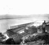
View of what was to become Seattle's Industrial south side and a major port
(University of Washington Library)
Picture by Asahel Curtis - brother of famed Indian photographer Edward Curtis

1901 Elliot Bay (University of Washington Library, Asahel Curtis)


2 comments:
In Timothy Egan's "Short Night of the Shadow Catcher" he elegantly describes how we (white, dominant, male) treated Princess Angeline as she lived on these tidal flats. A sad story, sad picture. We treated both the bay, land and the people badly. Great maps and chronology. In the 1875 map, what is the name of the Bay? Is it Salish? Or Samish? In the other's its Elliott Bay.
Duwamish Bay for the river. The maps and pictures are an impressive reminder of how reshaped Seattle is from its pre city days.
Post a Comment