This is post III on the south shore of the Bolton Peninsula (bolton-peninsula-introduction and bolton-peninsula-ii-notes-on-twin-river). While the exposure of bedrock was fun to see, the shore to the east gets more interesting. Before I proceed or you read, I should note that the observations presented are from a rather rapid walk on the shoreline to get to a slope site I was evaluating and I was a bit pressed for time. In my mind this shore reach needs a lot more contemplation and careful locating, but has a great story to tell for those that have the tools, skills and time to read it.
Approximate area of titled sediments
Birdseye (1976)
The reach of the locations shown is essentially along the reach of shore that says "Boulders"
A note on my observations on this reach are consistent with Birdseye (1976). Birdseye (1976) notes Double Bluff Till at the base of the bluff overlain by pre Vashon stratified sediments capped with Vashon Till. My confidence level of the till being Double Bluff is not certain, and I would assume it is based on stratigraphic elevation combined with the very hard nature of the sediments adjacent to the till suggesting an older till versus the Possession Till. That said, I have not observed an inteveing till between the base of teh slope and the top of the slope Vashon Till. An issue others may be able to shed some light on in the near future.
Glacial drift at base of the bluff that Birdseye (1976) interpreted as Double Bluff Till
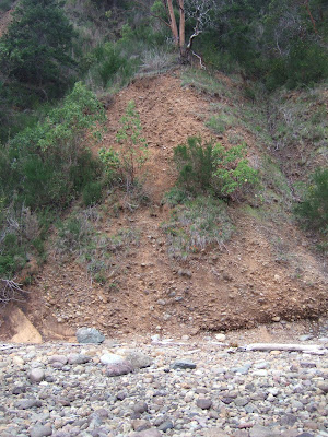
The till is a very hard compact mix of silt to gravel with occasional boulders deposited directly by glacial ice. The Double Bluff Till has been estimated to be 125 to 185 thousand years old (Polenz, Slaughter and Thorsen, 2005). The till exposure is very limited. Most of the bluff slopes in this area are underlain by tilted silts, sands and gravel beds. These units are the Pre Vashon Stratified Sediments with no age constraint and they are stratigraphically above the till shown above.
Northwest striking and northeast dipping alluvial sediments
My last observation along this reach of shore was what I interpreted at the time as a possible contact between the older tilted stratified sediments and perhaps a much younger Vashon age glacial drift. Did I really see this correctly? I took a quick couple of pictures and made a few mental notes on the location and hurried on my way so I could get up a very steep tricky trail before dark.
Possible erosional contact between younger gray drift/outwash on the right
and older oxidized sediments on the left.
View of same contact near the location where the bluff becomes lower
Note the presence of large glacial erratics on the beach at the location suggesting glacial till.
Whatever the case, the sedimentary units become horizontal to the east of the above site and another till unit is present at base of the bluff.


No comments:
Post a Comment