Friday, April 29, 2011

Dunite - Decorative, Heat Resistant and CO2 Sequestration

Visiting a local office in Bellingham today I noted the counter of the reception area was made from slabs of dunite.
Dunite counter top.

Later walking to the post office and courthouse for mail and research I saw a dunite bench along the Whatcom Creek trail.


Dunite bench along Whatcom Creek trail

Dunite is the from the earth's mantle and consists primarily of olivine. Dunite and other rocks with high iron and magnesium content are called ultramafite. The Twin Sisiters range in the Northwest Cascades consists almost entirely of dunite. The range is essentially a huge block of the earth's mantle somehow exhumed and thrust up into the Northwest Cascade Range (twin-sisters-range-and-dunite). A quarry on the lower slopes of the range extracts dunite as a liner for high temperature incinerators as olivine has a high melting temperature (its from the mantle of the earth). The rock is attractive so is also commonly used as a decorative stone. The downside of its use as decorative rock is that it is very hard and very massive with a specific gravity approximately twice that of average rocks. 

Ultramafic rocks such as dunite have gained interest as a means of sequestration of CO2 by the reaction Mg2SiO4 (Mg Olivine) + 2CO2 ---> 2MgCO3 (magnesite) + SiO2.  See Danae and others (2009) for an over view of site selection and Koukouzas and others (2009) for a bench study.  

In both examples above I like the orange weathering rind left on the edge of the counter and bench. This is the same color as the Twin Sisters range when the range is not mantled in snow as it was last week when I saw the range from near the South Fork Nooksack Valley. 

Twin Sisters viewed from Saxon

Thursday, April 28, 2011

Pacific Interdecadal Climate Oscillation (PDO) and Flood Plain Drainage - a Possible Linkage?

La Nina has been in the news the last few days. Snow level dropped to 500 feet last evening and I noted a few clumps of ice in the rain yesterday afternoon. The slopes of the Northwest Cascade Range have fresh snow this afternoon down to approximately 1,000 feet. Cliff Mass noted (are-springs-getting-worse) that between February 1 and April 15 there were only two days that reached 55 in Seattle, the fewest days of 55 plus weather during the same period ever.

This got me thinking about a problem I have been hearing about the past few months regarding farming in northwest Washington and Whatcom County in particular. The excellent glacial and alluvial soils combined with long hours of summer sun make for some rich and profitable farm land. However, cool,wet springs pose challenges to farmers trying to get crops planted to take advantage of the summer sun.

If it was simply cool weather, it would not be so bad, but the big problem is drainage. For farmers along river flood plains this presents a particularly difficult problem as drainage must be directed towards the rivers. Many western Washington farm areas are located on alluvial plains adjacent to rivers flowing off of the Cascade Range. While big floods that make the news and damage property take place during heavy mild rain storm events during the winter, the average flow on rivers flowing off the Cascades is highest during snow melt in late spring. With rivers high it is very difficult to drain farm fields and if the snow melt window of time is shortened due to late cool spring weather some rivers will flood farm fields along the river during this period and back up low land tributary streams that are critical for field drainage.

The continued very cool weather and still being added snow pack in the Cascades will likely pose some very difficult choices for farmers on flood plain areas subject to flooding or poor drainage from high river levels. The period of snow melt could be rather intense this year if a sudden warm up arrives in late May or early June flooding planted fields or preventing large swaths of land from being planted at all.  

Farmers along the flood plains of Nooksack River have been expressing concerns about drainage along the river and have presented anecdotal stories that the problem has been getting worse and spring planting times have been later along the lower flood plain. One theory that has been put forward is accumulation of sediment in the river is slowing drainage. The problem with this suggestion is that there is no data on the Nooksack to demonstrate that it is in fact the problem beyond anecdotal stories. What data is available suggests that river agradation is not a problem as agradation rates are very low overall on the lower Nooksack at this time. There is some data indicating that the Puyallup River near Tacoma has been agrading and causing drainage problems and flooding.

Another possibility is that the springs have been cooler and wetter than in the past. A paper by Mantura and others (1997) linked salmon decline with a periodic climate shifts in the Pacific they called the Pacific interdecadal climate oscillation (PDO). The PDO is a the result of several processes that combine to cause periods of cooler weather and water on a decadal basis. This pattern has significant impacts on salmon populations due to effects on ocean conditions. The pattern also impacts river flows another important factor for fish, but also an important factor for northwest farmers. Possibly it is the PDO that is causing flood plain farmers from getting onto their fields not sediment accumulation in the river. The follow up would be to see if there is a linkage to stream gage data similar to the pattern found by Mantura and others (1997) for larger northwest rivers and if spring temperatures and precipitation patterns might be shifting towards a less favorable condition for flood plain farmers.

PDO from 1900 to 2010 from Wikimedia Commons

The above chart of the PDO index suggests that a warm PDO index trend over the past three decades may shift to a cooler pattern and pose a problem fro some farms that was previously not nearly as common during their lifetime.

PDO since 1000 via Wikimedia Commons


Saltwater Economists and Songs about Growth and Community

I was catching up on economics by reading Paul Krugman and Brad DeLong, both saltwater economists, but from opposite coasts. They have been having a bit of a music exchange. Krugman started with Arcade Fire saying, "No particular reason to post this, except to provide something cheering after a tough day."


DeLong responded with another Arcade Fire song, Sprawl II (Mountains Beyond Mountains). This is the same song I attached to post on farmland in Lynden, Washington.


Paul Krugman responded on the same theme of growth and community with a song from the Pretenders, My City Was Gone.


Krugman readers suggested several songs regarding growth. I'll start with the classic growth song by Joni Mitchell, Big Yellow Taxi.


James Taylor sings Copperline, a nostalgic song about his childhood. For many Washington State residents this song may be fitting as many of the communities in the state have changed dramatically over the past several decades and what we may have loved about the communities we grew up in has been lost. Taylor only has one line about the growth that changed Copperline. In away it comes across of acceptance that things have changed.


Dust Poets perform Walk Away. In a way this song describes a challenge many Washington State and for that matter many communities across the country struggle with as "everything is on the edge of town". 


I have always been an open space kind of guy so have always loved the Cole Porter song Don't Fence Me In. I once visited the Roy Rogers Museum (I believe it has since closed). I am ashamed to admit I did not fully appreciate Trigger and Roy at the time. This clip is amazing. That is one smart horse and Roy sure could ride.  

I included this video of Neko Case's Thrice All American (Tacoma) about Washington State's Second City. This song is the opposite of growth. Tacoma was for a fairly long period a depressed city that had seen better days. I lived there for the better part of a year working on the cleanup of the Tacoma Tar Pits on the former Tacoma tidelands. I'm not sure many of or for that matter any of the images in the video are from Tacoma, but it is fun to watch none the less and I keep thinking I have met half the people shown. 


And lastly a big favorite, Gretchen Peters' performs Mary McCaslin's Praire in the Sky. 


Tuesday, April 26, 2011

A Few Notes on the Interstate-82 Landscape

I just got back from a trip to eastern Washington. Much of our view of the landscape is via what we see while zipping along interstate freeways. While slowing down to take back roads and making stops may lead to a better understanding of the land, frequently distance and the need to get somewhere in a short time precludes further exploration. So a few notes on a few drive by features along the I-82 route from Kennewick to Ellensburg.
Landslide east of Prosser.

Upon entering the Yakima Valley the freeway traverses the base of the steep front of the Horse Heaven Hills between Benton City and Prosser. The ridge line is a very asymmetric anticline and the fold is so tight along the ridge line that the rock basalt and relatively thin sediments between the basalt flows is highly fractured and may be slightly faulted as well. As such there are a large number of big landslides that give the slope a lumpy appearance. I always thought that these slopes would make a great ski area if only the climate was not so dry. The slides are very old features. Some of the slides appear related to the fact that the lower half of these slopes were inundated by the Missoula floods when water backed up at Wallula Gap. Most of the land on the steep slope is managed by the Bureau of Land Management with one section of Washington State Department of Natural Resources managed land. Cattle grazing has been allowed in the past, but if it currently is allowed it is at a much reduced level than in the past.

Rythmite silt deposits near Zillah

Near Zillah is a fantastic exposure of Missoula floods silt deposits. Each layer of silt was deposited by a flood event where the water was backed up the Yakima Valley during the numerous Missoula flood events. This is the best freeway view. These beds are often referred to as Touchet Beds as equivalent layers are preserved in the Walla Wall Valley near Touchet. The steep slope is a cut bank from the Yakima River which is located on the opposite side of the freeway. I always enjoy seeing this exposure.


Pushtay

I previously did a post on Pushtay HERE. I have often been asked about this out of place conical hill. The rest stop north of Selah is a worthwhile spot to take a break. A short walk to the fence line provides a nice view of Pushtay as well as the deeply incised Selah Creek canyon. This view is from the north bound rest stop, but the south bound stop is a great stop as well with overview of the Selah Cliffs Natural Area - Department of Natural Resources protected area with numerous rare plants.

Freeway bridge spanning Sehah Creek gorge

Interstate 82 leads to Interstate 90 near Ellensburg. Near Cle Elum, Will and I could see that the rain shadow had been in full effect and that we would be returning to cloudy rainy weather.

Clouds breaking apart while passing over the Cascade Range


Monday, April 25, 2011

Return of the Western Washington Jungle

Despite the cold and sometimes wet winter weather, I do like the ability to see through the brush that winter offers. It can be a lot easier to figure out slopes in the winter than in the jungle when visibility is obscured by plants. April is the month that plants begin to leaf out and in a short couple of weeks western Washington turns a bit jungle like and my ability to view slopes will be hampered. This year the change will be more rapid than in past years as the spring has been so cool that timing of plants leafing out is compressed. Early bloomers are out  as well as a few friends that take some getting used to.

Trillium

Skunk cabbage

Bracken

Stinging nettle

Devil's club

Friday, April 22, 2011

Raised Beach along the Seattle Fault


Olympic Range from the Bainbridge Island - Seattle Ferry

Seattle skyline from Bainbridge Island - Seattle Ferry

Wednesday morning I crossed Puget Sound on the Seattle to Bainbridge Island Ferry. I often think of the scenes from this ferry run as some of the classic images of western Washington. This may be in part due to some of my initial adventures in the Seattle area involved riding the ferry out to Bainbridge Island.


The landscape viewed from this ferry run has changed a bit from the first time I rode this ferry route. For one thing there are a lot more tall buildings on the Seattle skyline than the Space Needle and what was then called the black box. More recent additions are the two stadiums - one for football and one for baseball. The giant container loading cranes are also a new addition as Seattle remains a very competitive shipping port. And there is the addition of an armed escort from the Coast Guard that is a frequent companion of this ferry run but not very often on the other ferry routes.

Stadiums, cranes and the Coast Guard

Another addition is our understanding of the Seattle Fault zone. The view of Restoration Point at the southeast end of Bainbridge Island has taken on new meaning. The raised bedrock platform beach is a result of uplift within a portion of the fault zone.

Raised bedrock platform beach at Restoration Point southeast Bainbridge Island 

LiDAR image of south end of Bainbridge Island showing Toe Jam Fault raised platform beach. 

The uplifted bedrock platform at Restoration was suspected to be the result of a fault, but finding faults within the forested and glaciated Puget Sound Basin has been a challenge. The are several strands of the Seattle Fault zone expressed on the surface. The proximity of this fault system to population centers poses a significant threat. Surface ruptures as expressed along the Toe Jam Fault are an obvious indicator of seismic risk; however, not all seismic activity will have a surface expression. Someday many of Seattle's structures will be tested by this fault system. It has happened before and will happen again.   

Thursday, April 21, 2011

More to Ponder Regarding Tsunami Risk

There has been plenty to ponder regarding the events in Japan fr those living along the Cascadia subduction zone. I will be looking at more tsunami policy as well as earthquake issues. It is very important that our western Washington communities make wise decisions regarding earthquake and tsunami risks.

PBS has a nice story on tsunami risk on the west coast PBS.org/video. Has some good clips I had not seen from Santa Cruz, California.

This video gives a sense of scale and time of the approaching wave that is hard to grasp.


This next video is a close view of the seawalls designed for tsnuami protection. The walls look expensive and appear to work well until.... Stick it out to the end, it is humbling.

Tuesday, April 19, 2011

Wolf Trees on Orcas Island

Douglas fir wolf tree

Douglas fir wolf tree

Douglas fir wolf tree - great climbing tree

Trees growing in open ground such as a meadow, prairie, or a bald do not have neighbors to compete with for sun light and hence growing upward to reach sun light is not necessary. As low branches can still gather light without neighboring trees, solitary trees tend to keep their lower branches versus forest trees that loose lower branches as the light to the lower part of the tree is cut off by the canopy. Hence, solitary trees that grow in this environment have heavy large side branches and take on a markedly different growth pattern than trees that grow in a forested area.

In a forest setting Douglas fir grows straight like a pillar with a high crown of branches to capture the light at the top of the forest canopy.  Straight, knot free wood rates higher than wood with twisted grain and knots. Hence, trees that matured in a open setting are less desirable from a commercial timber perspective than the tall straight trees with few side branches.

The term wolf tree is an expression that these trees are greedy taking up nutrients and space at the expense of other trees and from a timber perspective are a pest as the tree is of little commercial value. The pest part being from a time when people viewed wolves as a pest (some people still do including some members of congress). The presence of heavily limbed Douglas fir within otherwise straight trees with few or no low side limbs indicates that the tree stood through a period of forest disturbance and grew for a period of time when the area was open and there were no other trees to compete with for light. A tree that survives a fire or a big blow down can become a wolf tree.

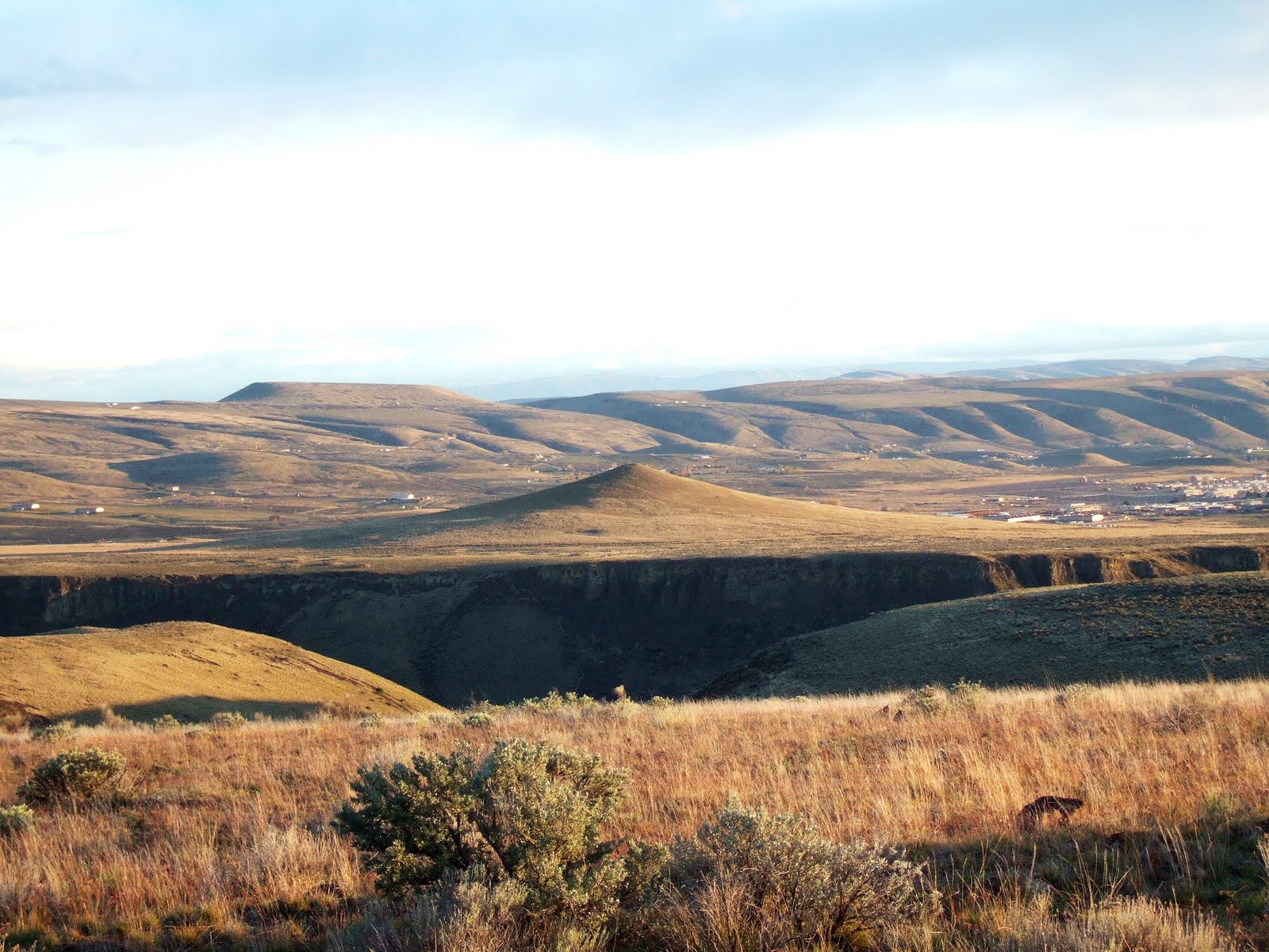
Due to frequent past forest disturbance old, heavily limbed Douglas fir are common in areas of the San Juan Islands. New wolf trees are developing in areas where balds and prairie are present. I observed the classic wolf tree pictured above growing in an opening on the slopes of Turtleback Mountain on Orcas Island. This is a area of very thin soil with a south facing slope and is within the rain shadow of the Olympic Mountains. Hence, the site is susceptible to draught and in the past frequent fires both natural and anthropogenic.

On other areas of Turtleback Mountain forest has developed around the wolf trees. The wolf trees indicate that prior to the forest the area had formerly been much more open. As the younger trees grow up around the wolf tree, the heavy lower branches will die, but of the large knots in the wood associated with the heavy limbs remain.

Wolf tree within a forest with old limbs dying off

Many old growth wolf trees survived initial timber harvest in the San Juans as they were of little value and were left alone. Much of the San Juan Islands was described as having poor timber during the initial timber harvest era in the late 1800s despite the proximity to water for transport. While the wolf trees may lack commercial timber value they certainty have a lot of character and are survivors.

Douglas fir wolf tree

Near the summit ridge of Turtleback Mountain I spotted a wolf tree that had blown over many years ago. The exposed roots had healed and one of the the limbs had become the lead tree.

Blown over wolf tree with one of the limbs taking over as the leader

Monday, April 18, 2011

A Week in the "Field"

I have been out in the field a fair bit the last several days including some weekend work. A few examples of my adventures the past week:

Bellingham marine drift and former topsoil exposed in excavation

Figuring out drainage

Viewing a big landslide - note house is about to follow the garage down the slope

Stream incising down through debris flood deposit

Sampling through a concrete floor - getting that rock out was a bit of a challenge

Early morning sun on the Salish Sea viewed from Orcas Island

Landslide investigation

Crow Valley, Mount Woolard and Mount Constitution, Orcas Island

Coalescing deltas at the head of Quilcene Bay with snow capped Mount Walker

White Rock, a big glacial erratic south of Port Ludlow

Cloaked flying saucers invading western Washington at sunset

Friday, April 15, 2011

April Showers


A bit of a surprise yesterday morning. A cold front moved in late the day before with cold air aloft. A convergence zone set up over northwest Washington early in the morning. As falling snow aloft fell it melted on the way down cooling the air enough to lower the snow level all the way to the surface. Classic April cold convergence event. A similar event took place a couple weeks ago in the Lynwood area between Everett and Seattle. I had a local field project in the morning so got to enjoy the snowy street slush. The snow stopped before flattening the just about to open tulips.  

Wednesday, April 13, 2011

Wallula Gap and Prime Farmland

Last week I posted a bit on the artist John Mix Stanley and Wallula Gap HERE. That very evening I spotted this juice at the grocery named for Wallula Gap along with a picture of the gap on the back of the bottle.


Wallula Juice

Wallula Gap played a critical role during the Missoula Floods. On multiple occasions a lake the size of one of the Great Lakes formed behind an ice dam in western Montana. Once the lake got deep enough, the ice dam floated and collapsed and the entire lake drained in a matter of couple of days. The flow of water exceeded 10 times the flow of all of the rivers in the world combined. The flood swept across eastern Washington and was held back by the narrow gap through the Horse Heaven Hills at Wallula Gap. The water filled the entire gap carving the steep cliffs of the gap seen today.

The gap is an impressive landscape to drive through or hike along the rim. But the gap played a huge role in shaping much of today's eastern Washington landscape. The flood water backed up forming the short lived Lake Lewis. The lake was 1,000 feet deep near the gap and covered the entire Pasco Basin, Yakima Valley, Walla Walla Valley and extended north past Moses Lake and east up the Snake River past Lewiston, Idaho.

Lake Lewis (Wikipedia Commons with markups added)

Silt carried by the flood waters was deposited over much of the area covered by the lake. Some of the silt was subsequently eroded in areas where currents flowed rapidly as the lake drained, or by later floods, or by wind erosion. But the richness of the soils underlying much of the farmland of the Yakima Valley, Walla Walla Valley and Pasco Basin is the result of the narrow Wallula Gap. Hence the name Wallula Organics pays homage to the geology of the area and the role Wallula Gap played in formation of the outstanding soils of area.   


Tuesday, April 12, 2011

Field Museum, Chicago - Enthusiasm For Earth History

Saiga antelope on left - the big nose is for warming and moistening cold air

I visited the Field Museum in Chicago two weeks ago. It was a fantastic museum. Full of surprises like the antelope above. I learned a lot - more than I could possibly retain.

But the highlight was seeing the enthusiasm for earth history and evolutionary science. I think that part excited me as much as the exhibits.

Computer animated Cambrian aquarium

Trilobites attracting attention

Sue is a popular photo op

As was this giant sloth

Every kid that walked by Lucy put his or her hand in the replicated hand of our ancient ancestor


The life history of the Earth ended with these two displays. Mass Extinction #6 is part of the Anthropocene - hopefully this latest extinction event won't be as bad as some of the previous events