Thursday, May 19, 2011

Channel Migration Zone (a bit wonky)

I am meeting with a class of fluvial geologists on Friday. So I cobbled together a recent project I did and decided to post it. I worked on this project as a public service project as a question regarding channel migration had come up on a creek. This post is a bit wonky. (Maybe they all are)

A couple months ago I did a channel migration zone assessment on a creek in north Whatcom County. The purpose of the project was to determine if the creek channel was migrating or potentially migrating. Knowing channel migration potential is important from a geologic risk perspective, but it is also important from a habitat perspective. Channel shifts create new habitat particularly for fish and this can be even more important when the fish in question are an endangered salmon or trout species.

I faced some difficult constraints on this project. I had one day to visit the site, and then one day to do some historic research and write a report. Said report was then submitted to the hearing examiner and then I needed to defend my conclusions in an adversarial setting in front of a hearing examiner with another expert on the other side and attorneys asking questions. Yikes!

The first thing I did was I pulled up a LiDAR image of the area. The creek channel was reasonably apparent as was the valley the creek was situated within and it looked like old channels or terraces were present. The LiDAR is a bit rough due to thick tree cover along areas of the creek. The lumpy areas in the image are forested and the trees interfere with the number of laser shots that reach the ground, particularly if the trees are thick evergreens.

Creek LiDAR image with my markup of channel migration line
Numbers are discussed below
The dark blue line is my interpretation of the channel migration line

The methodology typically utilized for delineating CMZs is to identify historic migration zones, avulsion hazard zones, erosion hazard zones and areas that are disconnected from migration. Rapp and Abbe (2003) developed a framework for delineating CMZs for Washington State Department of Transportation and Washington State Department of Ecology. Similar approaches have been utilized by Klowan (2004) and Perkins (2006) for rivers in Jefferson County, Washington 

Historic migration zones can be identified using historic aerial photographs or surveys. With much of the creek tree covered seeing the creek in historic aerial photographs was a bit challenging. It is even difficult to discern the creek location in the most recent aerial photograph in the vicinity of the area I was looking. However, upstream of the subject property, historic photographs do indicate that creek had migrated within the historic period. Rectifying and measuring these migrations can be very important in establishing migration distances if one has the time and budget. No such luck on this project, but the historic photograph review indicated that this creek did have a record of meandering about in its valley.

1950 aerial showing an old cut-off meander on upper right 
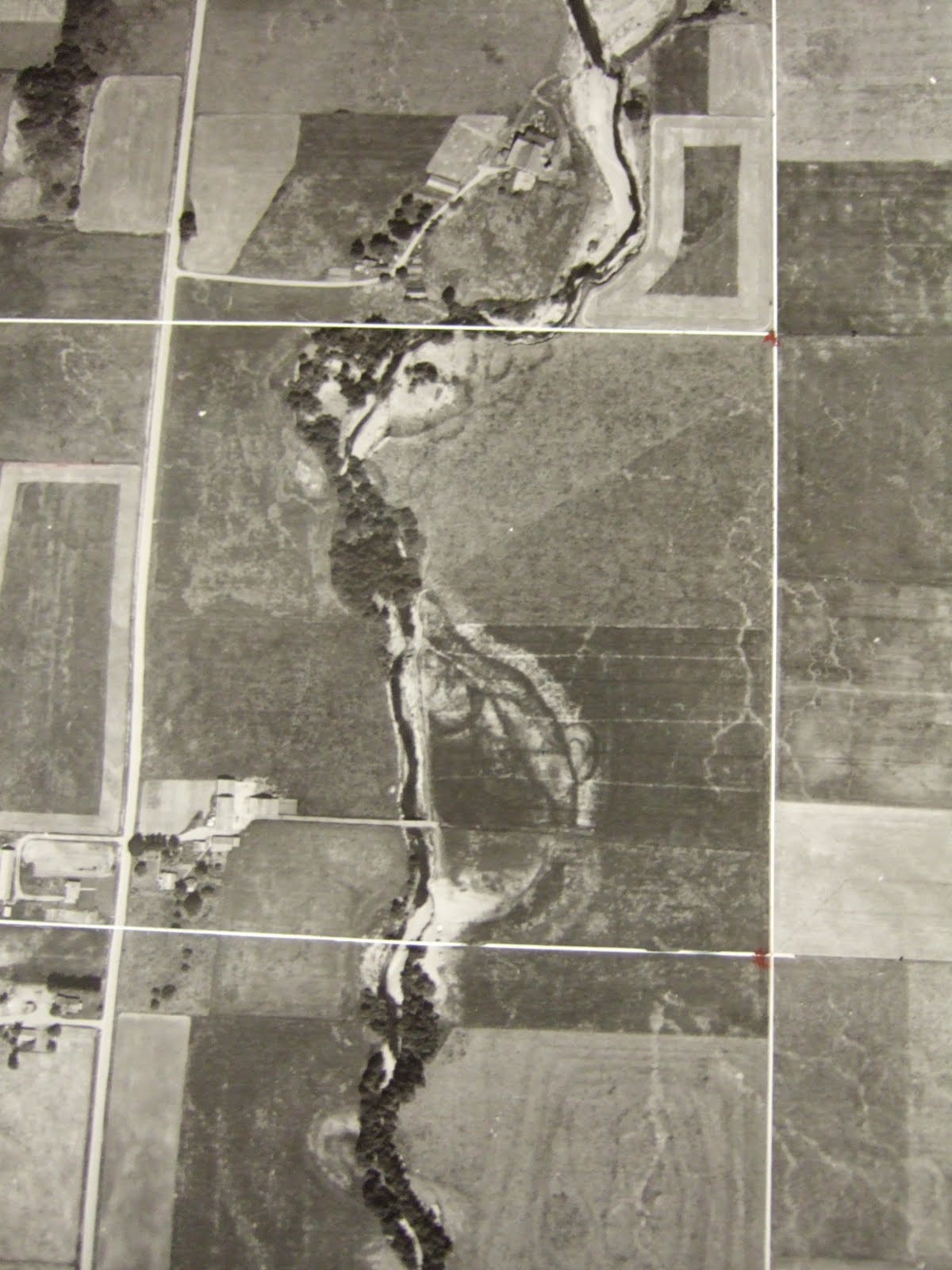

1961 aerial - note old cut-off meander on right

1975 aerial of same area with cut-off having faded after being farmed for years

1961 aerial - note old cut-off channel to left of trees 

1995 aerial - note old cut-off channel no longer as evident

So I had a LiDAR image showing that migration was certainly a possibility and had taken place in the past and I had historic aerials indicating past channel movement within the past century had taken place along the creek. I also had a county flood hazard map showing potential 100-year flood areas along the creek.

Part of a day in the field determining on the ground conditions with LiDAR, aerials and flood map in hand was the next step. It turns out this creek had a variety of channel migration features to consider. I numbered the features on the LiDAR and discussed the channel migration conditions for each location.

Area 1 (see LiDAR map above) is located upstream of the subject property but is a location where past erosion has taken place and where the creek is flowing directly into the bank at a nearly 90 degree angle. The LiDAR image indicates that a former channel was located to the west of this sharp bend. If the creek erodes through the bank this location is a potential avulsion point and the creek would follow the low ground to the west along the base of the slope to the upland area. Sure enough, after smashing through the blackberry brambles, I observed that the bank has clearly been eroded.

Area 2 would be subject to rapid erosion if an avulsion takes place in the low area upstream at Area 1. Area 2 is located along a low bank area on the northeast portion of the property. It appears that this area is subject to periodic flooding with overbank silt and fine sand deposits. However, most of this area was not flooded this past winter. Most of the recent erosion along Area 2 has been located on the opposite bank where upland slopes have been eroded, but a few spot locations of erosion are evident on the subject property in this area. It appears that this low bank is susceptible to erosion from large trees on the opposite bank falling into the creek and defecting flow against the bank.

Bank edge collapse along Area 2

Area 3 is an area of steep upland that has been undergoing recent active erosion. This area is outside of any historic or prehistoric channel area and the upland is well above flood levels but is actively being eroded as the channel migrates toward and undermines the bank area. This erosion hazard area and the resulting erosion and geotechnical setback would establish the CMZ back behind the steep slope well outside of the flood zone or ordinary high water mark.


High bank erosion. Bank consists of recessional glacial outwash sand and gravel

Area 4 is immediately downstream of the eroding high bank. This area appears to be flooded on a frequent basis and has a flood channel along the base of the high bank slope where some erosion has taken place, but the main channel is not located along the base of the high bank slope. The OHWM is located at the base of the upland slope in this area. The proposed Zone A flood zone does not include this area. The elevation of this area may not have been accurately picked up by the LiDAR.

Overbank flood channel along base of slope causes periodic erosion

Area 5 is a low bank area that is primarily brush and grass covered. A string of wetlands is located along the northwestern and western edge of this area at the base of the slope. The low spots with wetlands appear to be related to a partially filled in former channel. Flooding by the creek has deposited sediment in this area and over time has partially filled in the old channel. Area 5 is located on the outside bend in the creek. Recent erosion areas are present along parts of this bank.

Gravel bar downstream is directing the current towards the right bank

Undermined bank

Determining the potential for channel migration relies on geologic observations and interpretation and evaluation of overall stream processes taking place currently and projecting into the future. There is always a degree of uncertainty in this type of analyses. A very large significant flood event, major influx of sediment, or formation of log jams may alter conditions and cause very rapid channel migration even where little change had taken place historically. As observed on the site and in the vicinity, areas of upland that are outside of any previous channel area and that are well above the flood area are being eroded and should be considered to be within a projected channel migration area.

One final note. A lot of conditions that are current should not be considered as future conditions. Issues in particular come to mind regarding this creek: 1) a significant number of trees have been planted and maintained along the creek banks and over time some of these trees will fall into the creek diverting water against stream banks, 2) the head waters area of this stream has undergone some residential development and peak flows have been increasing, 3) beaver activity that has been greatly diminished for well over a century may increase as beavers recolonize the area.

Palouse Falls - A Remarkable Falls in a Remarkable Setting

Palouse Falls deep in a canyon carved through multiple layers of flood basalts.

John D'Onofrio did a write up on Palouse Falls in the Cascadia Weekly a_visit_to_palouse_falls. Palouse Falls is one of Washington State's true wonders. With the Cascade Range and the famous water falls of the Columbia River Gorge, Palouse Falls in the heart of one of the driest and hottest parts of the state is a remarkable outlier that is often forgotten. The waterfall alone is a wonder, but the setting and the story behind the landscape is a wonder as well.

The Palouse River flows from the moister and higher lands of Idaho and flows through the Palouse of Washington State. The Palouse is a large area of rolling hills constructed from a few million years of wind blown silt accumulations. The Palouse is a sea of wind swept wave-like hills with very deep, fertile soil. This soil overlays the Columbia River Basalts, one of the largest accumulations of basalts in the world.

Palouse with forest and prairie on steep slope between fields of winter wheat

Drier part of the Palouse showing hills constructed from wind blown silt

Massive silt typical of the Palouse area

The Palouse River previously flowed in a valley through the present day towns of Washtucna, Kahlotus and Connell and on to the Columbia River. However, during one of the great Missoula Floods, flood waters filled its entire valley with water spilling southward at numerous locations carving deep into fracture joints in the underlying bedrock of the Columbia River Basalts as the water headed towards the Snake River Canyon  (Previous Post on Devils Canyon). At a bend in the Palouse Valley this erosion was deep enough into one of the joints that after the flood was over the Palouse River continued flowing down this overflow route within a deep narrow bedrock gorge and the former river valley was left nearly dry with the exception of a few seasonal ponds.

Google Earth image of lower Palouse River
Dashed blue lines bracket the Missoula Flood corridor
Dashed blue arrows show former river route 

Former Palouse River valley near Kahlotus

As the Palouse River flows westward through the Palouse, it enters into an area of drier and drier climate. The area near Palouse Falls is one of the driest and hottest areas in the state with rainfall under 10 inches per year and very high summer temperatures that routinely pass 100 degrees. The river is in such a straight deep notch within the joint fracture, that unless you know the canyon is there it can not be seen until essentially reaching the canyon's shear edge. Note in the satellite image there are a number of other slots that were carved into the regional joint pattern which are now dry canyons. The uplands around the canyon have been stripped of soil from the Missoula Flood and the areas where the soil has not been stripped are just barely moist enough not to be active dune areas (there are active dunes a few miles to the southwest).

Road heading to Palouse Falls

This is a great time to visit the falls as the falls are in high water flow from snow melt in the mountains to the east. Jon D'Onofrio added a nice touch to his article, "We headed south out of the lonely hamlet of Washtucna through rolling hills that looked like a Lisa McShane painting and reached Palouse Falls State Park in the late afternoon". Indeed a number of Lisa's paintings are from that very area and she once lived in the now dry former Palouse River valley.

Wednesday, May 18, 2011

Drumlin Ridges on Mountainside

East side of Stewart Mountain from the South Fork Nooksack Valley

I took the picture above while investigating a riparian area on the South Fork Nooksack River. I liked the way the sun was lighting up the tops of the trees not only on the stand of poplars but on the slope behind. The step-like ridges on the mountain slope are glacial carved drumlin features on the side slope of the valley. Normally they are difficult to discern, but with light just right as when this picture was taken I can make out nine drumlin ridges formed by passage of ice from the right to the left.

LiDAR view of area. Image is approximately 2 miles across.

Monday, May 16, 2011

Beavers in the Anthropocene

Longest beaver dam in world, Wood Buffalo National Park, Canada

The fur trade began in Washington State in the 1700s when initially English ships soon followed by Russians, Spanish, and later Americans collected sea otter pelts along the coast for trade with China. Inland fur trading that had begun to the east progressed westward via river routes reaching what is now Washington State in the early 1800s. Fur trading posts established near the coast connected with the river routes and the river trade network. This era of fur trading had profound effects on the economics of the area and ultimately shaped the history and landscape of what is now called Washington State.

The rate of taking of furs was never remotely sustainable. For example the sea otter was nearly driven to extinction. Inland fur bearing animals did not fair much better. The Hudson Bay Company which ultimately developed as the dominant company may have developed some sense that fur trapping needed to be done in a manner that would not trap out the resource. However, with American encroachment and concerns that furs were attracting Americans, the Hudson Bay Company began an aggressive trapping approach to clear out furs that were attracting American interest in the hope of stemming the tide of American settlement in the Pacific Northwest.

The result was vast riparian areas devoid of beavers. As a consequence, the stream processes we observe today may not correlate well with the geomorphic features observed. I remind myself that beavers might once have been present in a stream system I am working on. And in trying to project into the future it is important that the possibility of future beaver activity could result in much different stream behavior than that currently observed.

Part of living in the Anthropocene is recognizing that human impacts on the geomorphic processes are not always by direct action. In addition, we need to recognize we are not the only species that impacts geomorphic processes.

Gloomy Weather Antidote

Thinking sunshine

It has been a remarkable spring in western Washington. Cliff Mass applied the barbecue index to our spring weather and determined it has been our worst spring (as measured by the index) ever coldest-spring-confirmed-with-barbecue-index. Even with early sunrise it is very dim this morning. I changed my computer screen background to the image above to brighten up the gloom. Silver Fox's write up and pictures on cross bedding HERE and Dana's bits on Arizona sediments HERE and HERE make for thoughts of sunnier climes to the south.

A brief note on turkey vultures - I have seen lots more vultures over the past few years and despite the cold and wet I observed several a couple of weeks ago while out on Orcas Island. This particular bird is enjoying the high plains of New Mexico during a very bad drought a few years ago.

Friday, May 13, 2011

Everson-Sumas Overflow

Overflow flood ways on the Mississippi River are in the news as flood waters are directed into overflow routes to ease flooding at other sites. A natural overflow route is located in northwest Whatcom on the Nooksack River. During large floods, part of the Nooksack River spills into the much smaller Sumas River and flows north into Canada and on to the Fraser River. 

Nooksack River with overflow route shown by the long arrow directed to the northwest

Nooksack River overflow route between the two small towns of Everson and Nooksack


The Canadians on the north side of the border are never very thrilled with part of the Nooksack River flooding the Sumas Valley which is a former lake bed so the flood waters cover a large area. The border town of Sumas is deeply flooded as well during these big floods.

The area where flood waters exit the Nooksack has been reduced by a levee in Everson. That levy combined with the widening of the bridge span has reduced frequency of flooding upstream of Everson, but may be causing more frequent downstream flooding. A good reason for coordinating flood plans and development planning.

Bridge at Everson and the Nooksack River

Everson Levee

The overflow route has been planned for flood water including flow. The road between Everson has been designed to be overtopped by flowing water.


Everson-Sumas overflow route looking east. Flood water approaches from the right. 


Over flow route looking west. The shoulder slope is paved so road shoulder is not eroded.

Wednesday, May 11, 2011

WA Supreme Court Rules in Favor of Fire District, Upholding Lone Council Member

Last Friday the Washington State Supreme Court issued a decision regarding an appeal filed by Fire District 21 in Whatcom County. The Court ruled that development projects should have been denied by the county because the Fire District had determined that it could not serve the projects and maintain the level of service (response times) they had determined http://www.courts.wa.gov/opinions/pdf/836116.opn.pdf. A number of development projects were proposed within the Fire District service area and the fire district would not issue a service letter. The district claimed that they could not maintain an adequate level of service in the district if the development projects went forward.

The County approved the developments anyway stating that, "on a more likely than not basis, that the Fire District will be able to continue to provide an adequate level of fire protection and emergency response services to the district, even with significant new growth, based on the currently authorized funding mechanisms available to the Fire District and increased taxes and fees paid by the new growth."

The County approval of the development was granted despite the county's own code which states, "No subdivision, commercial development or conditional uses shall be approved without a written finding that: (1) All providers of water, sewage disposal, schools, and fire protection serving the development have issued a letter that adequate capacity exists or arrangements have been made to provide adequate services for development, and (2) No county facilities will be reduced below applicable levels of service as a result of the development."

Goal 12 of Washington State's Growth Management Act. "(12) Public facilities and services. Ensure that those public facilities and services necessary to support development shall be adequate to serve the development at the time the development is available for occupancy and use without decreasing current service levels below locally established minimum standards."

The Washington State Supreme Court ruling may impact the direction of growth in Washington State toward areas where efficient delivery of service is more readily achieved and to areas where developers are willing to cover the costs that the development will have on a service provider. There is plenty of case law that service providers can not be arbitrary and capricious in denial of service as foot noted in the Court decision. An interesting take on the ruling and possible consequences by Tada Lisielius of GordonDerr is HERE.

On a personal note I heard the initial appeal of one the County approvals in 2007. It is nice after standing alone against the Hearing Examiner, County Planning Department, County attorney and my fellow council members to have the Washington State Supreme Court see things the same way I saw them.