I got a chance to see the Rattlesnake Ridge landslide as I has some work in Yakima. Not really much I can add to understanding this well news covered and monitored slide. However, I will comment that the agencies involved, Washington State Department of Natural Resources, Washington State Department of Transportation and the Yakima County Emergency Planning have been proactive and communicative with this slide. The precautionary approach and scenario planning is how this slide should be managed and that is what is being done.
The Seattle Times (seattletimes.com/can-experts-predict-collapse-at-washingtons-rattlesnake-ridge) has a good article on how the prediction method that is being applied with good quotes from geologists that shed some light on why the date of predicted failure is shifting. Precise predictions of the future tough in any field!
The New York Times also had an article: nytimes/washington-rattlesnake-ridge-landslide
I did have one quibble with NYT article "Even the name of the town, Union Gap, is testament to natural violence: It refers to a huge gash in the ridgeline carved thousands of years ago by a colossal flood from ancient Lake Missoula.".
The "huge gash" is a river gap where the Yakima River has incised through Rattlesnake Ridge. This gap was formed well before the ice age floods. Some of the largest floods did back up into Yakima through this gap, but the modification of the gap by the ice age floods would have been relatively moderate.
I did like the end of the NYT article. While various scenarios as to the size of the slide have been considered, Steven Slaughter with the DNR notes that one scenario would be the slide stopping. In that scenario the slide would be a lingering potential threat.
WDOT did assess deformation on the steep slope above Thorp Road and the Interstate and noted 5 feet of bulging on the steep slope. Given that the slope is essentially at an angle of repose, that 5-foot bulge will likely lead to a fair bit of slope ravel and rock fall towards Thorp Road.
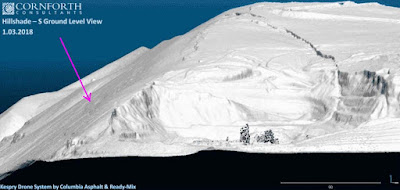
The consultancy that is working fro the rock quarry at the base of the slide has developed three time lidar images of the slide that if looked at carefully show that westward bulging.
rattlesnake+Ridge+Landslide&source


The Seattle Times (seattletimes.com/can-experts-predict-collapse-at-washingtons-rattlesnake-ridge) has a good article on how the prediction method that is being applied with good quotes from geologists that shed some light on why the date of predicted failure is shifting. Precise predictions of the future tough in any field!
The New York Times also had an article: nytimes/washington-rattlesnake-ridge-landslide
I did have one quibble with NYT article "Even the name of the town, Union Gap, is testament to natural violence: It refers to a huge gash in the ridgeline carved thousands of years ago by a colossal flood from ancient Lake Missoula.".
The "huge gash" is a river gap where the Yakima River has incised through Rattlesnake Ridge. This gap was formed well before the ice age floods. Some of the largest floods did back up into Yakima through this gap, but the modification of the gap by the ice age floods would have been relatively moderate.
I did like the end of the NYT article. While various scenarios as to the size of the slide have been considered, Steven Slaughter with the DNR notes that one scenario would be the slide stopping. In that scenario the slide would be a lingering potential threat.
WDOT did assess deformation on the steep slope above Thorp Road and the Interstate and noted 5 feet of bulging on the steep slope. Given that the slope is essentially at an angle of repose, that 5-foot bulge will likely lead to a fair bit of slope ravel and rock fall towards Thorp Road.
The consultancy that is working fro the rock quarry at the base of the slide has developed three time lidar images of the slide that if looked at carefully show that westward bulging.
rattlesnake+Ridge+Landslide&source


arrow point to change area of bulging slope, but the overall movement measurements are that the sliding is moving toward the quarry in the foreground


No comments:
Post a Comment