A bit more with more on the way regarding North Cascade glacier retreat. The Deming Glacier on the southwest side of Mount Baker is an important glacier for river flow in Whatcom County. The glacier drains into the Middle Fork of the Nooksack River. The City of Bellingham has a diversion dam on the Middle Fork that is sometimes used to augment water levels in Lake Whatcom, the city's main water source.
I outlined the glacial extent from the Mount Baker USGS topographic map.
The glacial ice extent on the map is from aerials taken in the 1980s. This point in time coincides with the end period of glacial ice advance on Mount Baker glaciers that ended in the 1980s.
Since the 1980s the glacial ice has retreated steadily back and is now even further back than the previous retreat that ended in the 1950s.
Blue lines mark the 1980s ice extent from USGS topographic maps
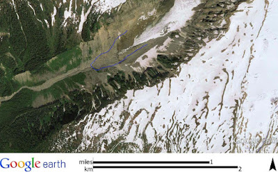
Terminal of Deming Glacier showing retreat since the 1980s (blue line)
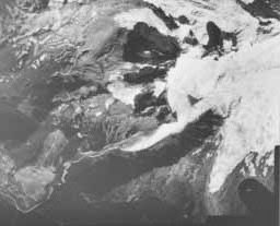
1950 aerial
1979
One can see the challenge of assessing precise ice margins in the 1950 aerial. The resolution is not great and with much of the lower end of the ice covered by debris, the actual terminus is a bit hard to determine.
More recent retreat can be seen in a Google earth view from 2013 and more retreat has been measured over the past two years.
Mass balance measurements are not available for the Deming Glacier. As important as this glacier is measuring mass balance is not a easy task and the Deming is too steep and crevasse covered to routinely venture out onto for making measurements. Hence, we only have a limited sense of ice mass based on terminal measurements. That said, recent investigations of terminal moraines on Mount Baker allow for some long term climate history since the last ice age
Latest_Pleistocene_and_Holocene_glacier_fluctuations_on_Mount_Baker_Washington.


No comments:
Post a Comment