The hard conglomerate of the formation forms cliffs and a few nice cascades on the stream Bob and I were exploring. The clasts in the conglomerate are derived from nearby metamorphic rocks of the Eastern Mélange Belt which is well exposed on the slope above this outcrop. The Eastern Mélange Belt consists of Triassic to Jurassic age ocean floor terrane thrust up onto the edge of North America. It is one of several accreted terranes in the Northwest Cascades.
Saturday, June 17, 2023
Rocks of Bulson Creek and Bulson Creek Falls, Skagit County
I have had several ventures on the steep north slope of Mount Frailey above Lake Cavanaugh in Skagit County. These ventures were to assess alluvial fan hazards which has meant assessing the steep drainages above the alluvial fans. Like much of the Northwest Cascades bedrock exposures are sometimes limited to stream channels. Hence the steep drainages on the north side of Frailey Mountain provided a good opportunity to see the bedrock hiding under the thick forest landscape. The lower slopes of Mount Frailey are underlain by sedimentary rocks called Rocks of Bulson Creek.
Conglomerate of Bulson Creek
Note weathered perimeter of greenstone cobble
The hard conglomerate of the formation forms cliffs and a few nice cascades on the stream Bob and I were exploring. The clasts in the conglomerate are derived from nearby metamorphic rocks of the Eastern Mélange Belt which is well exposed on the slope above this outcrop. The Eastern Mélange Belt consists of Triassic to Jurassic age ocean floor terrane thrust up onto the edge of North America. It is one of several accreted terranes in the Northwest Cascades.
The Rocks of Bulson Creek are Oligocene to Eocene and post date the terrane accretion. The Bulson appears to be deposited on the metamorphic rocks (Marcus, 1981) and appears to be a localized sedimentary in a localized basin that formed during the late to post Eocene time likely associated with the Devils Mountain-Darrington Fault (Lovseth, 1975 and Marcus, 1981). In the Lake McMurray area to the east the Bulson has clasts of Eocene to Oligocene volcanic rocks that are of local derivation.
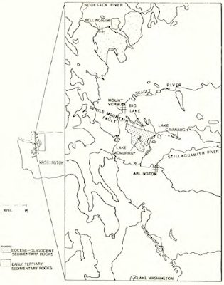
Distribution of Rocks of Bulson Creek from Marcus (1981)
Lovseth (1975) recognized the Bulson as a separate sedimentary unit than the similar looking Chuckanut Formation to the north. The Bulson is primarily marine while the Chuckanut is non marine. And while the base of the Chuckanut does contain locally derived clasts of Northwest Cascades rocks, most of the Chuckanut sediment is derived from a source area to the east of the Cascade Mountains at a time prior to the uplift of the range.
The term Rocks of Bulson Creek is from Bulson Creek located along a section of the Devils Mountain-Darrington Fault Zone. The creek incises down through the rocks and providing good exposures of a section of the formation. On the day of my venture up Frailey Mountain I also had a project along Bulson Creek and got a view of Bulson Creek Falls over a layer of hard conglomerate.
Saturday, June 10, 2023
Guarding the Cattle Guard
Upon approaching a cattle guard a local residence popped up to see what was coming. It stood there facing me. My anthropizing suggesting I was being challenged to proceed as this guard seemed to be standing its ground. I assumed it would be safe to cross and no harm would be befall either if us.
Saturday, June 3, 2023
A bit of wildlife viewing luck
I noted a couple of rabbits munching clover and dandelions in an open meadow. This observation was made by a bald eagle as well. The eagle swooped past me and landed on the rabbit.
After a minute pause and looking for potential thieves of its meal (including eyeing me), the eagle lifted off.
Monday, May 29, 2023
Former Giant Western Red Cedars above Lake Cavanaugh
I have had numerous ventures up the north slope of Frailey Mountain south of Lake Cavanaugh in Skagit County. The slopes are steep and streams on the mountain have had a history of debris flows; hence, I have had numerous ventures assessing the geology risks of the area.
The forest on the lower sloes is predominantly western hemlock. It is one of the easier forest areas to walk through as there is very little understory brush as the hemlocks shade out just about everything. But amongst the hemlocks are big(!) hints of the past.
Western red cedar stump amongst the western hemlocks
Large cedar stump and if you look carefully an even bigger one back in the trees
The western hemlock forest is about 80 years old. The Lake Cavanaugh area was nearly devoid of trees by 1940. There is a small remnant patch of old trees on the steepest upper slopes that were either too hard to log or poor quality timber.
The big stumps are a reminder that the forests we see today are not static. Given the age of the forests around Lake Cavanaugh area, there has been significant logging in the area the past few years. As noted in a previous post (HERE), the trees that were left are habitat for marbled murrlets and hence some of the forest is protected. And some of the slopes may be precluded from logging due to potential landslides and debris flow hazards. I say 'may' because that can be a geology judgement call clear cut logging has been permitted on active alluvial fan areas.Saturday, May 6, 2023
Colaptes auratus (Northern Flicker) Duel
I was alerted to the nearby presence of a northern flicker by the drumming on a metal gutter. The bird then swooped past my head and landed on the edge of a plowed area where he confronted another flicker.
The two birds pushed out there chests and faced off for several minutes. Occasionally one would jump upward and the other would respond in kind.
Thursday, May 4, 2023
Chrysemys picta takes a walk
Approaching a pond in eastern Washington there was a sudden loud splashing. It has been a cold spring, but on this day the sun was warm. The splashing was from turtles jumping into the water upon my approach.
Turtle heads in the water and one bolder turtle on the shore
While pausing nearby one the the turtles began walking across the grass away from the pond
A bit later I heard rustling and saw the turtle in a patch of bark chips
This turtle kept going across a street and off to parts unknown to me at least
Monday, April 24, 2023
Olympia Nonglacial sediments south of Penn Cove
I had a venture on the east coast of Whidbey Island a bit south of Penn Cove. The geology strata changes rather substantially along the shore. The last time I had been to this shore reach the tide was not favorable but this time I could take in some of the nuances of the bluff geology.
The carbon-rich layer at the base of the bluff provides an age of about 35,000 years (Polenz, Slaughter and Thorse, 2005). These are non glacial sediments deposited during the period prior to the last incursion of glacial ice out of British Columbia into the Puget lowlands. These non glacial units have been termed Olympia deposits.
The fine silt/clay layering is horizontal but there is an overprint of oxidized iron staining that confuses the eye as the staining is a bit convoluted.
Thick layer of glacial till forming bluff cliffs just to the southeast of the Olympia non glacial sediment exposures and off sets.
Subscribe to:
Posts (Atom)

