Friday, December 23, 2022

Notes on Sweet and others (2022) Seal Level Rise

Earlier this year Sweet and others(2022) updated Sweet and others (2017): Global and Regional Sea Level Rise Scenarios for the United State. Sweet and others (2017) suggested global sea level (GMSL) will rise as between 0.3 meters and 2.5 meters by 2100. Sweet and others (2022) find the high end of 2.5 m by 2100 less plausible. The bad news is that the rate of GMSL rise has been increasing and Sweet and others (2022) project that the rise in GMSL over the next 30 years will be as much as that over the past 100 years. The 2022 report notes a high level in confidence for their sea level rise scenarios over the next 30 years. Post 30 years the confidence level for sea levels is lower primarily because of uncertainty regarding some of the ice sheets in Greenland and Antarctica.  

GMSL is not simple and the sea level rise is not uniform around the planet. Some places will see greater sea level rise and others less. The 2017 report included an image of global sea level rise from 1992 to 2016 derived from satellite data measurements. 


Figure from Sweet and others (2017)

Global sea level has rises in an uneven manner due to currents, warm water expansion, and changes to gravity fields from more water in the oceans (the Earth's surface is flexible). The sea level also can vary due to cyclical climate patterns that move the ocean water around via wind and temperature patterns. I like to think that the ocean layer as having weather only slower and a bit less pronounced than the atmosphere. The image above also shows that on the Washington State coast the global sea level trend was near neutral for the 1992-2016 time period.

The 2022 report has an image with three plots showing global sea level rise along the coast of North America. 


Figure 2.1 from Sweet and others (2022) Regional sea level linear rates of rise (mm/year) from satellite altimetry over three different time periods: (a) 1993–2006, (b) 2007–2020, and (c) 1993–2020. Linear rates of change of relative sea level (ocean and land height changes) from tide gauges over the same time period are also shown (circles). 

For Washington State the 1993 to 2006 period the regional sea level rise was mostly neutral, but the more recent period of 2007 to 2020 shows that regional sea level on the Washington coast has increased as has the regional rates in most places around North America. 

The global and regional sea level increase is not a simple uniform rise. There is an added complexity: while regional sea level is changing, the land next to the sea is also changing in level. More on that on a future soon post.


Sunday, December 18, 2022

The Two Hat Islands in Washington State

I visited Hat Island in Possession Sound west of Everett this week. The icy thick fog in the morning prevented a good picture of the island, but but I had a nice view from the island. 

View from a high bluff on Hat Island looking south to the Mukilteo Ferry and Whidbey Island coast

Just the week before I had a nice view of Hat Island in Padilla Bay east of Anacortes. 

Hat Island viewed from the west in Guemes Channel 

How can there be two Hat Islands in the same state?  

If one zooms in on the USGS National Map the Possession Sound Hat Island has two names.  


I have always thought of the island in Possession Sound as Hat Island. The community of homes and lots on the island is called Hat Island and the ferry (private) is the Hat Island Ferry. However, its official name on the USGS topographic map is Gedney Island. The name was given to the island by Wilkes following a common custom of the time of the random naming things for associates or friends that never came near the area. Waterman (2017) provides some background on Gedney and his role in the La Amistad case. Gedney's claims on the La Amistad and it cargo may explain why locals preferred using the name Hat Island. 

The Hat Island in Padilla Bay is a Washington State Natural Resource Conservation Area. Perhaps an official name change is in order for one or both of the Hats.      

Monday, October 24, 2022

Mary McCaslin - Prairie In The Sky

Mary McCaslin died earlier this month (nytimes./music/mary-mccaslin). Mary McCaslin wrote and sang a number of songs that always stuck with me - enough so that I could sing them through myself years after. Prairie in the Sky still resonates. I believe Mary and I shared a similar romantic view of the West. In elementary school I would always pick 'Home on the Range' whenever it was my turn to pick a song. Prairie in the Sky better captures that childhood longing to be out on the open range and essentially replaced that older song in my music list.    

Friday, October 21, 2022

Former Placer Mining on the Columbia River

A gold rush in the Cariboo District of British Columbia resulted in an influx of miners passing through Washington Territory in the late 1850s and 1860s. Some of the miners traveling along the Columbia and Okanogan River took to placer mining at the gravel bars along the rivers. Splawn (1917) described 50 miners working the gravel bar at the south side of the Columbia River at the confluence with the Okanogan River in the early 1860s. Much of the placer mining working river bars on the Columbia River was undertaken by Chinese miners.  

Much of those placer mine workings have been submerged as the result of dams on the Columbia River. During a recent project I came across some old trenches on a terrace above the Columbia River well upstream of the Okanogan-Columbia confluence. The 1860s and 1870s placer mines were not documented operations and the archeological record is a bit thin.

I took a look at lidar bare earth imagery and found two obvious placer mine sites -- both partially submerged on gravel bars along the river between Grande Coulee Dam and Chief Joseph Dam.    


The Chinese operated placer miners primarily operated in the 1860s through the 1870s (Evenson, 2016). There are references to troubles with First Nations with one description of a massacre of the miners south of Chelan. Some of the placer sites were further worked in the early 1900s and I suspect that was the case at the two sites shown above. 

Reference:

Evenson, Lindsey M., "Pre-1900s Chinese placer mining in northeastern Washington State: an archaeological investigation" (2016). EWU Masters Thesis Collection. 358.   

Splawn, A.J., "Ka-Mi-Akin, the Last Hero of the Yakimas", (1917)

Friday, September 30, 2022

My First Pronghorn Spotting in Washington State

Antilocapra americana (pronghorn antelope) have been reintroduced to Washington State first by the Yakama Nation in south central Washington and a few years ago by the Colville Confederated Tribes in north central Washington. I finally saw my first Washington State pronghorn last week.   

These two are from the Colville introduction. I had been told that that some of the pronghorns from Colville had crossed the Columbia River and these two were south of the river in northern Douglas County. This area of Douglas has a fair bit of scrub steppe land. The area was glaciated and has large areas of very thin soils over bedrock or thin glacial soils. As such cultivation has been very limited with grazing operations being the main historic land use and very few humans. All and all good wildlife habitat with pronghorns being new entrant after a period of absence.

The Yakama pronghorns have expanded their range as well and the herd numbers have held up post reintroduction (https://wdfw.wa.gov/publications/02288).  

Sunday, June 5, 2022

Shuksan Greenschist

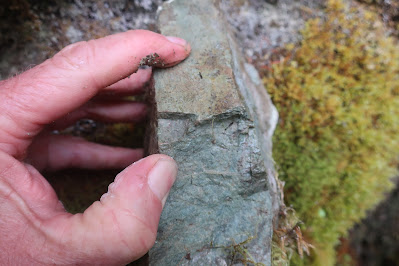
I had a work venture up the Skagit Valley near Marblemount. A major tectonic structure is located near Marblemout, the Straight Creek-Fraser River Fault. The fault is a strike slip fault with the west side having moved about 60 miles to the north. Movement took place about during the Eocene. The fault divides the Northwest Cascades to the west from the Cascade Crystalline Core to the east. Near Marblemount the rocks on the west side of the fault consist of the Shuksan Greenschist.

Shuksan Greenschist near Marblmount, Washington

The Shuksan Greenschist is named for the famous mountain, Mount Shuksan. 

Mount Shuksan

There is a good chance that you have seen pictures of Mount Shuksan as viewed from Picture Lake. Ned Brown noted in his book Mountain Building Geology in the Pacific Northwest that he saw a mural of Mount Shuksan in a coffee house in Japan. The back of my 4th grade class located nearly 1,000 miles from Shuksan had a mural of Mount Shuksan and Picture Lake and I saw the same mural image in a taverna in Greece.
   
The Shuksan Greenschist is metamorphosed ocean floor basalt and is part of the Easton Metamorphic Suite, one of the many accreted terranes in Washington State. The Easton Terrane is an ocean floor terrane that includes thick ocean floor basalt and gabbro and deep ocean floor sediments. The age of the original terrane is between 170 and 130 million years old. The basalts and gabbro have undergone multiple metamorphic events. The initial metamorphism of some of the areas of the Shuksan ocean floor was from hot fluids post eruption of the basalts and crystallization of the gabbros (Haugerud, 1980). The primary metamorphic event was during accretion to the margin of North America when the basalt and gabbro were metamorphosed into greenschist and in some areas blueschist from high pressures during deep burial in the accretion zone along the edge of North America. Further low grade metamorphism took place during post accretion emplacement tectonic events. 

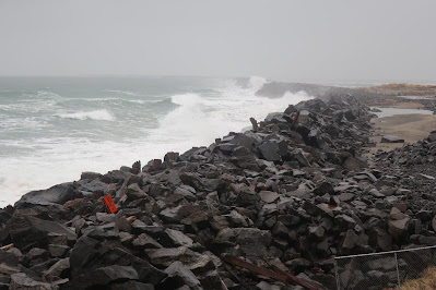
Shuksan Greenschist has a high density and in places where the joint sets in the rock are widely spaced, the rock breaks into large heavy blocks that make for good ocean jetty rocks, in particular at the mouth of the Columbia River (skagit-county-greenschist). This possible use has generated some interest in mining into a mountain side a bit west of Marblemount. My venture took me past the potential mine site. 

Cliffs of Shuksan Greenschist west of Marblemount
Site of on again off again proposed rock quarry

Last winter I visited the south jetty at the Columbia River. 

Jetty at the Mouth of the Columbia River

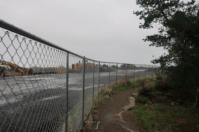
Blocks of greenschist at jetty construction site


Saturday, March 26, 2022

False Bay, San Juan Island

False Bay, San Juan Island, looking towards the head of the bay

False Bay viewed from the head of the bay looking towards the bay entrance
 from the Strait of Juan de Fuca

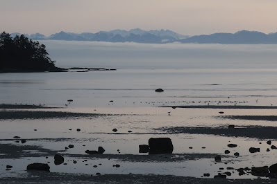
False Bay is an oval shaped bay on the south shore of San Juan Island. The bay is very shallow and much of it nearly empties during low tides; hence the name. The bay faces the Strait of Juan de Fuca. The day of my last visit was high overcast so the jagged skyline of the Olympic Mountains could be seen across the Strait rising above a band of low stratus. 

Portions of the bay are bedrock shorelines, but most of the bay shore is lined silt/clay bluffs of glacial drift. The drift consists both of glacial till and glacial marine drift. The till was deposited directly by glacial ice when a few thousand feet of ice covered the area approximately 18,000 to 14,000 years ago. When the ice thinned the area was inundated by sea water with ice floating on the surface. The mass of thick ice had pushed the land surface downward hundreds of feet. The melting glacial ice floating on the sea dropped sediment onto the sea floor. After the land rebounded from the ice load, the former muddy sea floor emerged and is now exposed along the low bluffs along much of the shore of False Bay. 

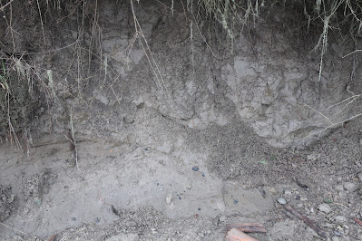
Glacial drift on bluff slope
The glacial till is on the lower part of the picture
Glacial marine drift with desiccation fractures in the marine drift   

Subtle contact between the glacial till and glacial marine drift

The glacial marine drift is susceptible to large landslides due to the weakness in the unit from the desiccation fractures. 

The glacial drift in this area is mostly clay and silt, but there are some cobbles and boulders embedded in the silt/clay. This silt/clay sediment source has created extensive mud flats with scattered boulders throughout much of the bay with a few areas where bedrock rises as islands or tidal submerged outcrops. Shifting tidal currents and waves have winnowed the gravel and sand from the mud forming sandbars and gravel bars that are exposed on the tide flats when the tide recedes.

Muddy tidelands with bedrock outcrops 

The bedrock is mapped as Orcas Chert along the south portion of the bay and Constitution on the north (Schasse, 2003). It is not a good bay for ships to venture into seeking safe harbor. While not so good for ships, the mix of muddy tidal flats with sand and gravel tidal areas, boulders, bedrock outcrops and freshwater streams flowing into the bay makes for a very complex estuary with a range of habitats. The bay tidal land is owned by the University of Washington and is managed as a biological preserve. The wide variety of tidal habitats is a great study area.

Oyster catchers eat what they study