Wednesday, June 16, 2010
Wall Flowers
As an engineering geologist I on occasion work on retaining wall designs. I am rather proud of my own retaining wall work. I used rocks from an old wall. The cut slope that the rocks front is a mix of soil and highly weathered weak siltstone and sandstone bedrock of the Chuckanut Formation at one end and a mix of bricks and soil and rocks at the other end. The cut slope was created when the City of Bellingham regraded the alley in the 1930s.
I had to rebuild part of the wall after I took it down as part of a sewer line replacement. The old garage could not be accessed due to the steepness of the new slope between the alley and the garage. So the "driveway" was no more than a wide path that was plant covered. When we dismantled our chimney about 10 years ago, the good bricks were mostly given away to friends that built patios with them. The broken bricks then were used to partially fill the driveway and I used the old wall rocks that lined the sides of the driveway to build the retaining wall. (Just a note - as much as I like fire places as a geologist I have a fear of brick chimneys)
Since then I have selectively pushed various drought tolerant plant seeds into the spaces between the rocks. The wall has put on a nice display in the alley this past spring.
Tuesday, June 15, 2010
Oliver BC Debris Flow and Similar Marshall Hill Debris Flow
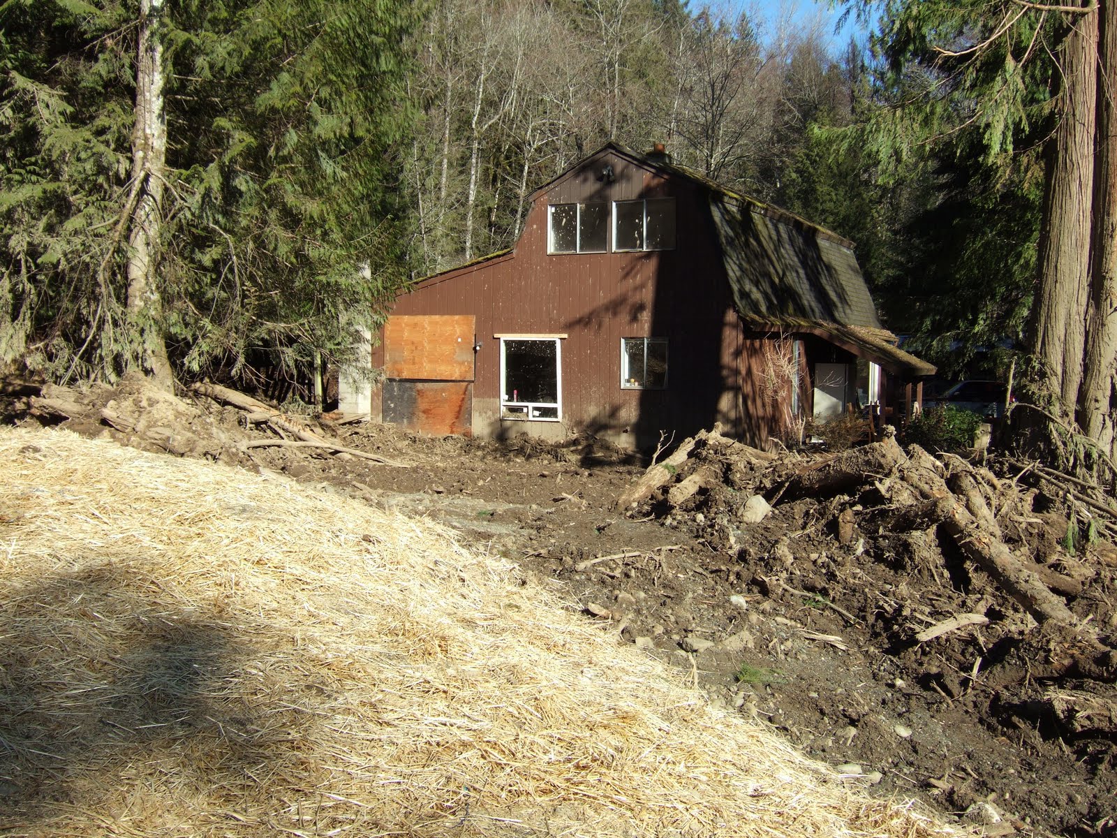
In the case of the debris flow in Whatcom County, the trigger was a failed stream crossing that held water backed up into a wetland. The failure took place during a rain on snow event. A fairly deep, low elevation snow pack had developed from several weeks of cold and snowy weather. A heavy rain storm then hit the area. This storm was a bit unusual in that it was a fairly cold rain so the areas with rapid snow melt were limited to lower elevations. Numerous landslides impacted the region with a concentrated area in the low mountains of Whatcom County.
The debris flow that blocked the highway was one of the more dramatic slides, but other slides in the area destroyed homes and roads as well. A few days after the debris flow I walked up the drainage to determine the cause. There were reports that recent logging and logging road construction had taken place in the area with the suggestion that this recent activity may have played a role.
The lower drainage just above the fan was very steep with vertical water falls over Chuckanut Formation sandstone. When I reached the recent clear cuts and logging road stream crossings, it was evident that the source of the debris flood was further up the slope. Three logging road stream crossings were destroyed by the debris flow. The source of the debris flow was not very dramatic relative to the impacts. A very old stream crossing in the upper watershed was simply missing. Immediately downstream the debris flows damage began. As the surge of water headed down the stream it picked up more debris and triggered additional erosion and slope failures. In places the debris flow ripped up chunks of bedrock.
Abandoned and forgotten logging road stream crossings have long been identified as a source of stream damaging debris flow events. Steep streams such as this stream in Whatcom County are subject to debris flows. However, the frequency and magnitude of the debris flow events is increased by unnatural dams created by the old crossings. When these road crossings fail, the surge of water and sediment can be enough to create a moving debris flow that will travel all the way to the alluvial fan below. Besides impacts to structures on the alluvial fans, the greater frequency and magnitude of these debris flow events as been identified as a problem for salmon habitat.
In this stream’s case the volume of water behind the crossing was exceptionally large. Based on snow along the margins and on logs within the wetland, I estimated approximately one acre foot of water surged down the stream.
Monday, June 14, 2010
Debris Flow on a Sunny Day in Oliver, British Columbia
Alluvial fans are geologically hazardous areas with risks consisting of debris flow/flood hazard, flood hazard, and erosion hazard. I took the picture below in the same valley on the Washington State side of the border. This fan is much steeper. A similar fan 600 feet to the north had a house on the central part of the fan. The take away message is that the small creeks associated with these alluvial fans are capable of behaving in a very dangerous manner and home and building site selection should take that into account.
Thursday, June 10, 2010
Bellingham's Waterfront (former)
Pickett never did fight any First Nation peoples, but a neighbor dispute over a pig eating potatoes nearly got Pickett into a battle with British forces in 1859. The Oregon Treaty of 1846 had set the border between U.S. and British territory as the 49th parallel. However, control over the San Juan Islands was not settled and the said pig dispute between a British citizen and an American citizen led to Pickett leading a force of American soldiers to San Juan Island to counter a similar move by the British. Fortunately discipline and common sense prevailed and Pickett avoided battle.
Pickett got more fight than he ever wanted four years later at Gettysburg where he commanded a full division that was ordered to charge the Union lines. Everything I ever read about that charge was that it was a terrible slaughter and should never have been done. Pickett’s division showed great bravery, but it was a lost cause.
The other historic building is the oldest brick building in Washington State. The building was built on 1859 serving initially as a Courthouse. The bricks were shipped from Philadelphia by boat. Given the fate of many of the splendid historic buildings in Bellingham, it is amazing that this building survived. A splendid stone courthouse building built in 1890 was sold in 1953 and torn down.
Fortunately, Carl Akers purchased the original courthouse building in 1955 and along with the an old historic school building he purchased saved a little bit of Bellingham’s history so that Bellingham not only can claim the first brick building, Bellingham can take pride, thanks to the Akers family, in that the building is still standing. One can only wish a similar approach had been taken with other buildings.
The old brick building location allows for some perspective on how the Bellingham water front has changed. Initially the building was built essentially right on the shoreline and was two stories tall. Later the area was filled in with a combination of soils from graded hill slopes, dredge spoils for navigation and garbage. Yes, Bellingham used its tide lands as garbage dumps all the way up till the 1970s! The location of the old brick building on the shore is an historic marker showing how much Bellingham’s shoreline has accreted. Essentially all that accretion has been man made.
Wednesday, June 9, 2010
Shifting Landscapes and Shifting Values
The Whatcom Creek estuary has certainly seen a number of transformations. I recently walked down to the mouth of the creek along the creek side trail to take a look at the old mill site. It’s a nice walk from my office as I am only a half block from the creek and walk across the creek every day. The weather had been rainy so the creek was flowing very high. More than enough flow to run the saws in the old mill.
There is very little evidence left of the mill and the site is now part of a city park. Over the past view years significant restoration has taken place along the banks of the stream. The site was initially valued by First Nation people as great fishing spot. Salmon still swim up the falls and its a great spot to watch for jumping fish in the fall. When the mill began operation, it was a lonely outpost of industrial development surrounded by a landscape covered with forest and natural resources. Now the reverse is true, the site is now a small natural area surrounded by an urban landscape. The change to a more natural stream estuary may reflect a change in values, but it also represents the shifting of the value of the resource. Natural areas in a city setting are a rare commodity and thus more valuable, and water powered saw mills and water transport are no longer as valuable as they once were due to electrical power and the presence of rail and roads.
Friday, June 4, 2010
Coyote Calling Cards
Alternatively coyotes have definitely adapted well to the presence of man and their range has expanded significantly. And I must say I find walking roads a lot easier going than straight cross country forest traverses. I also observed some other interesting wildlife adaptation. I had our dog with with me and when we exited the forest we encountered a couple of rabbits. The rabbits saw the dog before Sam saw them and then scurried over to join a group of chickens for protection.
Tuesday, June 1, 2010
Dodging a Slide
Checking out YouTube videos of landslides I came across this slide on Johannesburg Mountain. Not a spectacular slide, but likely fatal if you were on the avalanche deposits at the base of the slide. This site is in the North Cascades at the end of the South Cascade River Road. It is also in my thesis area. Ned Brown and I traversed the cone of ice where the slide in the video ended. A few small rocks flew past us while we were there. We did not spend a lot of time in the middle of the ice pile at the base of the slope. Fast walking with a constant eye looking up the slope and helmets on.
The bedrock consists of highly metamorphosed Cascade River Schist. The rocks at the base of Johannesburg got an added cooking from the intrusion of the Cascade Pass Dike approximately 15 million years ago. This later cooking obscured what I was really looking for - a metamorphic signature of the deep burial of the area. That find came a year later and a few miles to the north.