Thursday, December 30, 2010

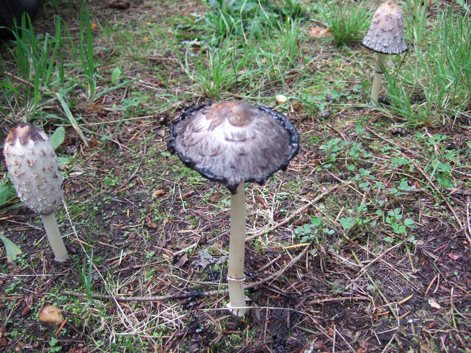
Shaggy Mane Sequence


I was going through some fall photos for a report I am working on and came across this sequence of mushroom pictures.  This particular mushroom is a shaggy mane. Good to eat only when new and then it proceeds to turn into what looks like blobs of ink. The ink blobs are full of spores.


I am not a mushroom expert and have limited my mushroom picking to very few mushrooms. Any good mushroom book will cause some pause unless you develop a lot of confidence. But mushrooms are a part of the western Washington landscape that has inspired a culture of mushroom connoisseurs. New shaggy manes are eatable before they turn into unappetizing blobs of ink.

Tuesday, December 28, 2010

Missoula Flood Routes in the Snow

Quincy Lakes Wildlife Area looking south with The Gorge further to the south and the Columbia River to the west (right). The diagonal line across the upper middle is Interstate-90.  

I think I picked a good year not be traveling through London or New York at Christmas time. When I do fly I try to sit by the window. I suspect many geologists have sore necks from having their head turned to look out the window. I always enjoy trying to figure out where I am and what I am seeing.

I took the above picture on a recent flight from Seattle to Kansas City. The rain shadow effect had created a cloud free area over eastern Washington and I had this great view of the Quincy Lakes Wildlife Area with its deep Missoula Flood channels, dry water falls and flood gouged lakes above the Columbia River on the right side of the picture. This one of several flood routes that altered the eastern Washington landscape during the last ice age.

A smaller nick point on the right side to the south of the main channels is the site of The Gorge. The erosion by the spilling waters carved an amphitheater with great acoustics and great views. The site is used for large concerts in the summer. I'm fairly sure that the Dave Mathews Band has not done a Christmas concert here yet, but have paid several visits in the summer.  

A little past the Gorge and Quincy Lakes Wildlife Area I got a view of yet another Missoula Flood Channel, The Winchester Wasteway and the North Columbia Basin Wildlife Area and the South Columbia Basin Wildlife Area. Water from the Columbia Basin Irrigation Project is routed through this natural drainage route carved by the Missoula Floods. The lakes and fresh water have developed into outstanding bird and fishing areas. 

Winchester Wasteway looking south. The sharp straight line is Interstate-90

With the snow the channels were easy to see and trace. Much easier than figuring them out on the ground like Bretz did. A little further east before the clouds obscured my view I got a view of Moses Lake and Potholes Reservoir.


View looking south of mostly frozen Moses Lake crossed by Interstate-90 with Potholes Reservoir further south and not yet frozen 

Wednesday, December 22, 2010

Wading for Geology

Shore of Discovery Bay

In the quest for greater scientific understanding one sometimes must get wet. I find it safer and much faster to wade than smashing through brush and tree limbs on slippery landslide surfaces. Besides this particular slide was covered with Nootka rose thickets. Given the choice yesterday, I went with wet legs versus brush wrestling and rose thorns.

Preglacial tidal sediments (?) possibly deposited during the advance of the Puget and Juan de Fuca ice lobes

Tuesday, December 21, 2010

Eclipse and Snow in Bellingham


The last couple of nights have brought a few small surprises. Sunday night we had a somewhat unexpected snow at roughly 2:00 am. Brightened up the night and early morning during our shortest days of the year.

And last night we were able to watch the eclipse. Given that it was cloudy all day yesterday and is cloudy again this morning it was an unexpected treat. I took the picture by sticking my camera lens into a binocular eye piece. Not exactly high quality optics and and hard to hold steady while taking the shot.

Sunday, December 19, 2010

Pushtay, an Odd Hill Near Selah, Washington

Pushtay on the eastern portion of the Yakima Firing Center

Topography map of Pushtay (note different name on the topo map)

A relatively small but odd hill is located east of Interstate-82 northeast of Selah, Washington on the U.S. Army's Yakima Firing Center. It is a bit hard to capture its out of place appearance. It is nearly a perfectly conical hill located on the south side of a broad slope of a large anticlinal ridge of the Yakima fold belt. The overall landscape of the area is broad sweeping valleys and ridges defined by the folded layers of basalt along with deep sharp edged canyons incised down through the folds. Hence this hill with its conical shape stands out as an oddity.

The base of the hill as well as the surrounding broad slope it rises from is underlain by the Pomona Member of the Saddle Mountains Basalt of the Columbia River Basalt Group. The Pomona basalt is approximately 12 million years old. Most of the hill itself consists of alluvial sediments that were deposited between eruptions of basalt during the upper Miocene. The particular unit on the hill is less than 12 million years old. Younger basalt lavas are present in eastern Washington; however, after the Pomona flows the volumes of later flows were substantially less voluminous. The only younger flows in the area that could have capped Pushtay is the Elephant Mountain basalt, but that flow is fairly thin in the area and may not have ever capped the alluvial sediments underlying Pushtay. The very peak area of the hill has been mapped as being underlain by Pliocene gravels that have been dated at 3.6 million years old.

The alluvial sediments that make up Pushtay were deposited by the ancestral Yakima River and perhaps also the Columbia River. The Yakima and the Columbia were pushed to the west by the repeated floods of basalt lava that filled the basin in eastern Washington. The river(s) likely was carrying a large sediment load from uplift and volcanic activity in the Cascade Range.

The Yakima River is an antecedent river. That is the river was there before the ridges formed. As south to north compression continued the Yakima fold belt lifted up the ridges that the river now cuts through. The meandering nature of the ancestal river is preserved where the river is entrenched into deeply incised valleys through the ridge areas particularly to the north of Selah in the Yakima Canyon - a classic example of entrenched meanders of an antecedent river.

Yakima Canyon topography with entrenched meander loop within Yakima Fold Belt ridges between Ellensburg and Selah

The antecedent nature of the Yakima River can be also readily be observed just north of Yakima and south of Yakima where both the river and Interstate-82 squeeze through Selah Gap north of Yakima and Union Gap south of Yakima.

Yakima River north and south of Yakima (Google maps)

A tributary stream to the Yakima (Selah Creek) is likewise entrenched in the uplifted fold very near Pushtay and can be seen on the topographic map showing Pushtay. This tributary canyon is crossed by the Interstate via a spectacular bridge.

The Yakima flows into the Columbia River. Not yet well understood changes in the area the Columbia River cuts through the Cascade Range likely caused an increase in gradient on the Yakima and thus increased the rate of down cutting by the Yakima further enhancing the entrenched nature of the current river. Possible changes on the Columbia River route through the Cascade Range may have been the result of volcanic activity.

Pushtay is a relatively isolated remnant of the old valley sediments from prior to the entrenchment of the Yakima. It is likely that the original remnant alluvial deposit that forms Pushtay was a somewhat different shape, but over the tens of thousands of years of frost action, wind and occasional sheet wash erosion from rare intense storms the hill was shaped into its current conical shape. Another factor to consider regarding the relative uniqueness of this hill is that similar features that may have once been present along the Yakima at lower elevations would have been obliterated by flood waters from the Missoula Floods that would have inundated areas below 1,200 feet. Pushtay at 1,845 feet as well the surrounding slopes would have been above the reach of the flood waters.

A look at the topographic map shows that Pushtay went by another name for many years. The name was changed to Pushtay after the Yakima Nation, Wanapum Tribe, and the U.S. Army made a request to the Board of Geographic Names for the name change in 1999. Pushtay means small mound in the local Yakima language. I have to admit the second part of the old name is descriptive and it may have been the first part that was more offensive.

Friday, December 17, 2010

Maury Island and Mining

North end of run ways at Seattle Tacoma Airport

While getting ready for takeoff I took this picture of the end of the run way at Seattle-Tacoma Airport. Big airports cover lots of ground and alter the landscape significantly. In the case of this airport lots of fill was required to extend the run ways over a low area at the north end of the runways. Bridges were constructed to support landing lights beyond the ends of the runway. But the changes to the landscape extend beyond the airport. All that fill has to come from somewhere and so the changes to the landscape take place elsewhere as well.

East shore of Maury Island

One source of sand and gravel is visible right after take off. The west shore of Maury Island has several mines. The mining takes place in glacial advance outwash, deposits of sand and gravel associated with melt water from the advancing glacial ice that pushed down into Puget Sound from the north. These deposits are particularly thick on Muary Island. Cal-Portland a Japanese owned concrete producer planned a major mine expansion on the island about ten years ago. The permitting process has taken a very long time primarily because the mine proposed using water access to ship via barge the mined aggregate. Without the ability to ship by water the value of the deposit is limited due to the low demand on Maury Island and Vashon Island (the two islands are actually attached via a narrow neck of land).

There are a variety of permits that are needed for any gravel mine, but water access and the construction of a pier involve more permitting than the mine itself. A variety of groups opposed the pier construction, but the mine obtained most of the permits until 2009 when a Federal Court judge ruled that the Army Corps of Engineers needed to do a more in depth analysis of the proposed pier and how noise and shading from construction and operation might harm orcas and chinook salmon, both of which are listed as endangered species. David Mann who recently argued a Freedom of Information case before the U.S. Supreme Court regarding another Washington Island was the attorney for groups appealing the Army Corps initial permit (see HERE)

After that decision the mining company became more receptive to selling the land and leaving the project. In April 2010 the Washington State Legislature approved $14.5 million for purchasing the land. King County Council approved $19.1 million dollars in November 2010 as well as a non monetary agreement worth $2.4 million regarding another mine site that is owned by the county but leased to the mining company. There is a commitment of $2 million by non profit groups to partially offset the County's purchase. 

The State money comes from a settlement fund paid to the state by another mining company, ASARCO. ASRCO operated a smelter in Tacoma for many years and one legacy from that smelter is an area wide contamination of lead and arsenic from air borne deposition. One of the places most impacted by the smelter is the Maury Island and Vashon Island area, so there is a link between using the money at the location to offset the damages caused by the smelter. The County money is from a Conservation Tax, a property tax for purchasing properties for public open space. Many Washington Counties have such a fund. In King County the fund collection is bolstered by the high value of land in the most populous county in the state.

From a gravel mining perspective, this means that the value of other deposits that could serve the area or have an easier time accessing water will increase in value and demand. Gravel mining already takes place with water access south of Tacoma and a pit in Jefferson County near Hood Canal has proposed a conveyor system to load barges. There is a small rock quarry on Lummi Island in Whatcom County with water access and several mines in the straits between Vancouver Island and main land British Columbia.  But other market factors also play a role. Some projects may not be constructed if the prce of aggragate gets too high or projects may be redesigned to use less aggregate or different materials.

At this point it looks like a new park with water access is in the works for the east shore of Maury Island. The geologic map that covers Maury Island (Booth, 1991) notes that the area of homes that can be seen on the photo above is modified land associated with mining. Post mining development is not uncommon. Shopping centers have been built in the old mines in Monroe and a residential development and championship golf course have been in development south of Tacoma in an area mined out.       

Wednesday, December 15, 2010

A few geology views and a bit from that other Washington

I've been traveling. I am not a highly wired person so typically very limited posting when I travel. A few geology views and a bit from that other Washington. And I missed the big storms in western Washington.

Mount Rainier rises above the low clouds - classic view for air travelers out of or into Seattle. The small cloud cap on the summit is a frequent warning of bad weather on the way.

Missouri River and oxbow from valley wide channel migration approaching Kansas City

Great view in the other Washington.
I very much enjoyed the beer I had while sitting at this window.
And, yes, we had a great time

The southern end of a big glacial lake and the city of Chicago