Saturday, June 1, 2019

Glacier Peak Tephra on the Waterville Plateau

Geology is a critical component of agriculture. The recessional glacial outwash plains around Lynden in northwest Washington formed some of the best agricultural lands in western Washington. The narrow gap at Wallula in the Horse Heaven Hills backed up ice age flood waters which in turn filled the Yakima and Walla Walla valleys with thick blankets of silt (lake-lewis-and-wallula). 

I had a nice geology outing with a soil scientist last week. It was informative interaction and we were traversing through country where Jay had completed soil mapping projects. Jay noted subtle features in the soil I would never have noticed without him.     

Note tiny tan grains

The small grains in the soil are tiny pieces of volcanic tephra. Given the central Washington location and the distribution of the grains Jay described, the source of the tephra is likely from Glacier Peak (Porter, 1978 and Kuehn and others, 2009).

(Kuehn and others, 2009)

This seeming small feature is a big deal to the local agricultural productivity. The tephra fragments allow the soil to hold a lot more moisture and thus adds significantly to the productivity of the fields where the volcanic material is present. The various tephra deposits are an important dating tool and thus tephra deposits are of great interest to more than geologists. Glacier Peak had a particularly violent eruptive period during and after the last glacial period. Mount Saint Helens and Mount Mazama also deposit tephra over a large areas. The three volcanoes have left dating markers over wide swaths of teh northwest.

Thursday, May 30, 2019

Skagit County Greenschist Headed to the Columbia

It is a bit unusual to see a single rock being transported on the highway.

Large rock on I-5 north bound through the Chuckanuts

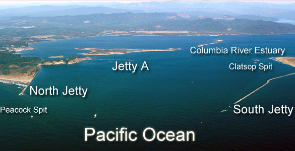
Large rocks are being transported from the Big Lake Quarry in Skagit County northward to to the Bellingham waterfront and from there to the North Jetty at the Columbia River.

 
Mouth of The Columbia River

The rock is greenschist - metamorphosed ocean floor basalt. It was mined from one of the terranes that make up the Northwest Cascades. The advantage of this rock is they can be broken into very large blocks, they have high density relative to other rocks and are resistant to both physical and chemical weathering. Good material for a jetty that must resist huge waves. 

This has resulted in a proposal to mine additional greenschist in the Skagit Valley with a mine proposed at a greenschist outcrop near Marblemount.  

Tuesday, May 28, 2019

Recessional Glacial Lake Sediments and Riparia riparia

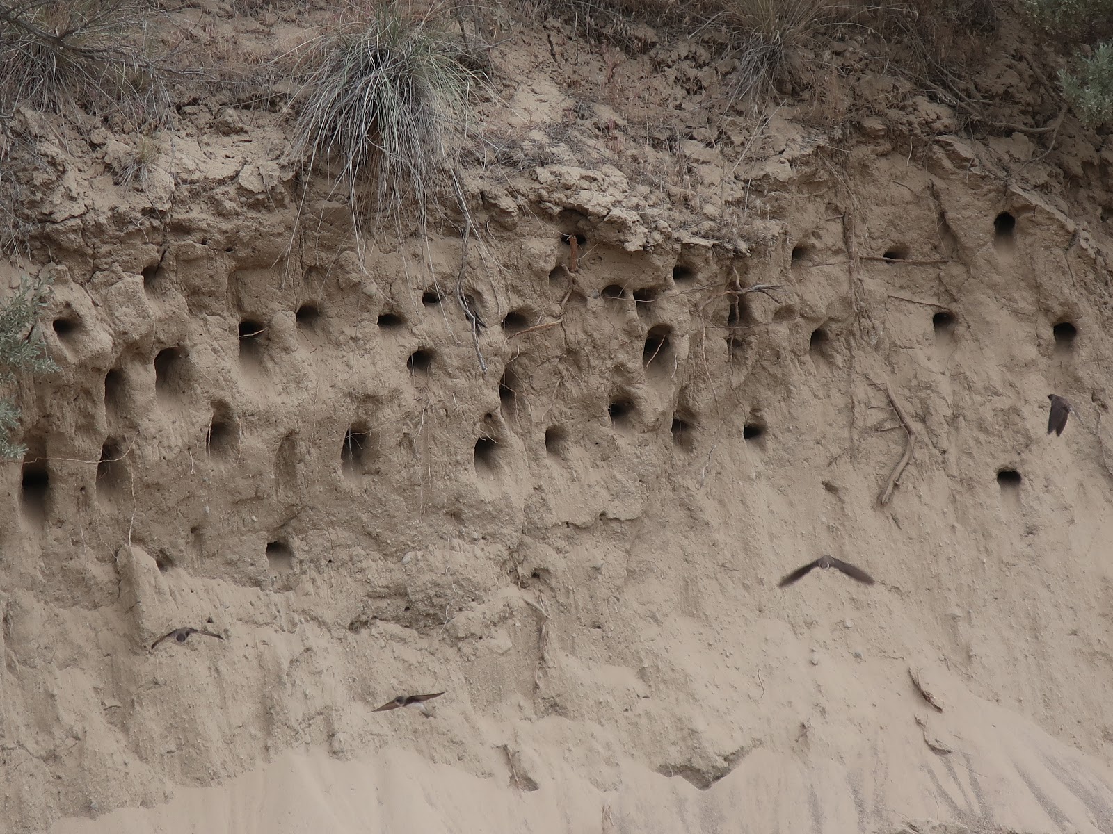
A road cut through a recessional glacial lake deposit above the Columbia River provided good nesting for a group of Riparia riparia (bank swallow). 


The swallows were very intent on feeding and getting food to their young inside the excavated nests. Another road cut further up the road had failed this winter and also had a steep bank with glacial lake silts exposed on the upper slope and again supporting a number of swallow burrow nests.


Thursday, May 9, 2019

New Logo for Stratum Group

Work level has been busy of late. While I was away from the office my associates put up our new sign with the new logo for Stratum Group. 


After 21 years Stratum Group has a new logo.


We also have a round version:


High snow clad peaks rising above the landscape is a fairly typical view over much of Washington State. We had some help with the logo concept from Amanda. I greatly appreciated her efforts to improve our look without completely abandoning the old logo:


The old logo retired after 21 years

I drew the old logo using autocad. It was a poor resolution figure that we just never got around to improving until Kim said it was time up our game.  

Wednesday, May 1, 2019

Yakima Canyon Notes

I picked a glorious day to drive the Yakima Canyon route between Ellensburg and Selah. The first stop was to stretch the legs at a pull out above the river at the north end of the canyon. Some fellow travelers were taking in the road cut geology.  

The brown unit on the right is a basalt flow mixed with lake sediments and water. The black rock is the cleaner upper part of the flow. The whitish unit is lake sediments deposited on the basalt and then on the left the sequence begins to repeat.

I chatted with the folks at the exposure, they are big fans of http://www.nickzentner.com/central-rocks. Nick does have a nice video on the Yakima Canyon.    

Early spring leaf out along the river

Lines of talus. This feature is thought to be formed primarily by summer cloud-burst rain events (Kaatz, 2001). These types of events are not common, but Kaatz suggested that they are a primary geomorphic process in eastern Washington that had been perhaps under appreciated. 

Soil covered talus and debris flow exposed in road cut. 

Following the entrenched meander of the river 

Yellow bloom of Balsamorhiza sagittata 

Fold in the basalt - the river is cutting through the Yakima Fold Belt

Friday, April 19, 2019

Snow Geese on Samish and Skagit Flats Have Not Left Yet

After being on eastern and central Washington ventures, I wondered in the snow Geese had left the Skagit and Samish flats for their breeding grounds on Wrangel Island in the Russian Arctic. The question was readily answered as the main flock flew over me while I traversed the flats.    


Apparently the leave date varies for these birds (Stevick, 2017). A later leave date may present problems as the flock may do a heavy graze on fields that have been planted. In this case the field has not yet been planted and the field that the flock was leaving is a Fish and Wildlife holding.   

Monday, April 15, 2019

Rock Fall Momentum: An Example at Highway 397

The construction of Highway 397 was completed to provide a bypass around Kennewick to the east side of the city and to Finley. The route through the Horse Heaven Hills involved a number of cut and fills to achieve acceptable grades on the highway. One spot where there was excess cut material at the grade down to Zintel Canyon made for a nice illustration of momentum and rock fall run out. 

2004 image of cut and fill work on a portion of 397. 
Cut material was used to fill the side canyon the road was crossing.

2006 image of excess cut material deposited on the slope below the cut area
 
On the ground view looking up at slope

A boulder that traveled well beyond where most of the other rocks stopped

Several rocks traversed the entire slope to the valley bottom

Not a particularly complex concept, but a nice illustration of how the larger boulders with greater mass and thus initial momentum had enough energy to travel well beyond the distance of most of the smaller rocks that had been disposed of at the top of the slope.