Monday, August 26, 2013

Cedars are our friends

I was reminded last week of an old geology friend, Chuck Ziegler. I assisted Chuck during his graduate school work in the Northwest Cascades. The reminder came while I was traversing up a fairly classic slope that is common on many of the Salish Sea coastal bluffs - cliffy on the bottom where waves had eroded and under cut the slope, steep mid slope with slopes of 45 to 60 degrees covered with trees and thick brush on up to a vertical cap underlain by glacial till.

With the very top of the bluff capped with concrete like glacial till, my route to the top of the bluff was blocked. I moved laterally along the base of the vertical obstruction looking for a way up and hoping I would find one before some obstruction would force me down the bluff or worse force a complete back track across difficult terrain I had already traversed.

A well located western red cedar, though small, combined with a few other hand and foot holds saved me from a long nasty slog through the steep woods. As I wrapped my hand around the thin branch I remembered Chuck saying, "Cedars are our friends". The strong fibrous wood of the western red cedar makes a good natural trusty rope when available.         

My hand hold before pulling myself up

Glacial till cap on a woodsy shoreline bluff

Sunday, August 25, 2013

Lummi Formation Notes

Had a chance to look at some Lummi Formation. The Lummi Formation crops out on the east side of the San Juan Islands and of course Lummi Island where its named is derived. The formation is a chunk of Cretaceous to Jurassic ocean floor. It is one of numerous blocks and slices of terrains that have been accreted onto the North American margin. Where the story of this unit and others gets complicated is just what happened after the initial accretion. 

The particular portion of the formation I was observed was primarily a portion that is a turbidite sequence. Turbidites are sediments that have been deposited on the sea floor via density currents resulting from under water landslides. The sediment creates high density fluid in the water and flows down and out across the slope of the ocean floor. The sequence of events starts with sediment piling up on the shallow sea floor near the coast from rivers and streams. The loose saturated sediment then collapses as an under water landslide. As the density current propagates across the deep ocean floor, the heavy sediment is deposited first and then the sediment fines upward. If the site of deposition is at just the right spot, a sequence of gravel fining up to fine silt will be deposited, but more often only part of the range of sediment is deposited in a given spot or the upper part of the sequence might get eroded by later density currents. Sites far from the landslide will be dominantly fine grained silts and clays. Sites that are closer may be dominated by gravel and sand. Repeated slides will take place as sediment gets piled up again along the near shore by streams and rivers. The slides might be correlated with repeated earthquakes along the coast that will readily trigger under water slides, but the slides can take place without quakes as well.
 
For the most part the section I was looking at consisted of alternating silt and sand layers suggesting a fairly distal location out away from the high energy flows or at least on a quieter part of the turbidite fans that were built out onto the sea floor.

The bedding orientation was very easy to measure at this site with alternating beds of siltstone and sandstone.

The Lummi Formation has been metamorphosed and on some of the bedding plain surfaces faint lineations were present.

 
A common feature at this particular spot was rip up clasts of dark silt embedded within the sand stone. In this case the density current ripped up chunks of previously deposited silt that was then deposited within the sand.


When the only units are alternating siltstone and sandstone determining which was is up in the original formation can be tricky. But a layer of conglomerate grading into sandstone allows for that determination.

Conglomerate grading upward with pen pointing towards the original up direction.
In this case up is slightly downward and to the right.
The dark 'pebbles' are small rip of clasts of siltstone that were eroded by the density current that carried the gravel.

Monday, August 19, 2013

Steptoe Butte

Steptoe Butte

Steptoe Butte rises above the rolling Palouse of eastern Washington. It is a bit tricky to get a sense of scale. When I first spotted the peak I thought I was seeing Mount Hood, but that would have been an absurd view given how far east I was. The butte rises approximately 1,100 feet above the surrounding rolling hills, but its isolated location makes it stand out as an impressive high point.

The peak is underlain by Precambrian rocks that Waggoner (1984) placed in the Ravalli Group. Due to its isolated exposure the interpretation is a bit tentative.

The butte lends its name to a geologic term. A steptoe is an isolated island of older rock surrounded by younger formations. In this case the billion year plus rocks of Steptoe Butte rise above 15 million year old basalt lava that buried everything else in the area. The butte also rises above vast loess deposits of the wind blown sediment that blew out of the Columbia Basin and settled as a thick blanket of silt over the Palouse creating the rich farmland of the Palouse region of Washington State. Why the butte was not buried in a layer of thick loess is a question that adds to the curiosity of this isolated peak.

The grass and wheat covered ground in the image above is for the most part underlain by the Palouse silts and as such are rich active farmland. The dark band of forest in the low area in the mid distance between the viewer and Steptoe Butte is the Rock Creek drainage. Here the palouse silts were scoured out by ice age floods leaving the area not very viable for wheat growing and instead it is a mix of grazing and pine forest.  

Steptoe Butte was named for Colonel Steptoe. However, the butte should not be confused with the hill where Steptoe and his men fought off an Indian attack before escaping near the town of Rosalia.    

Saturday, August 17, 2013

Thursday, August 15, 2013

Internal Waves at Hales Passage

The two photographs below I took may not exactly be anything to get excited about. However, this was a new observation for me. I had the pleasure of doing some field time with a few other folks versus my usual solo trips and Elizabeth and Bert spotted internal waves in Hales Passage between Lummi Island and Portage Island. 
 
Internal waves in Hales Passage
Portage Island on the left
Bellingham Bay extends behind Portage Island

Closer view of internal waves
 
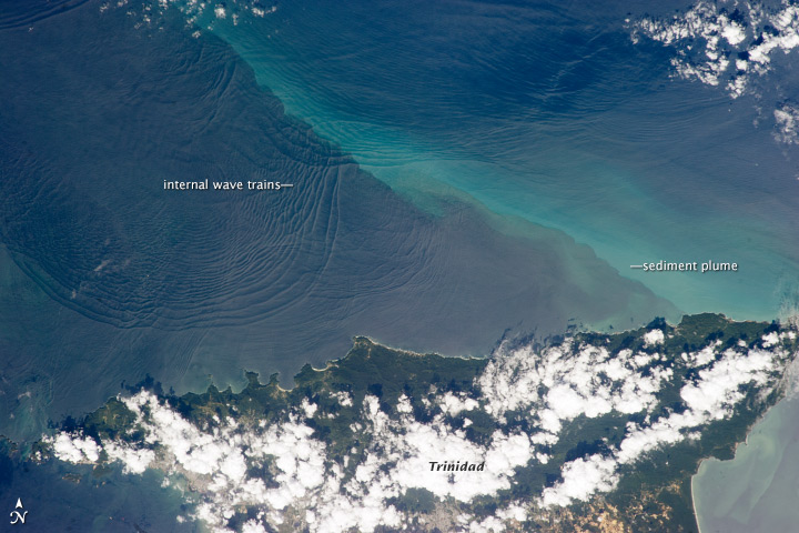
Bert and Elizabeth have a better image of internal waves in Pacific Northwest waters  http://www.raincoastgeo.org/home.html and NASA has an image from space as well:
 
File:ISS034-E-032377annotated.jpg
 
The waves are the result of waves between different density layers in the water at depth that express themselves on the surface as very slow moving waves. A good reminder that water needs to be thought of three dimensionally.

Monday, August 12, 2013

The Big Draining: Flathead Lake to Lake Pend Oreille

I've been east of the Washington State landscape. While not the primary purpose of my travels, I did see some features in Montana that played a huge role in the shaping a large swath of the Washington landscape and for that matter a good chunk of Oregon as well. 
 
 
Faint horizontal lines on the slope of the mostly grass covered hill in the center of the picture are wave cut terraces small beaches when the slope was on the shores of Lake Missoula. Many of the valleys of western Montana filled with water during the last glacial period when the Clark Fork River drainage was blocked by glacial ice at what is now Lake Pend Oreille in northern Idaho. The above and following images of the wave cuts terraces are in the southern Flathead River valley. 
 

The wave marks are very subtle in this image and show up as alignments of more brush vegetation

 
Besides the glacial ice blocking of the Clark Fork, there were plenty of other glaciers in the area. The Rocky Mountain Trench was filled with glacial ice. The Flathead valley located at the southern end of the Trench was the terminus of the great ice lobe that poured down the Trench. Flathead Lake, the largest fresh water lake west of the Mississippi River, formed behind the terminal moraine left behind by the Rocky Mountain Trench ice lobe.

Upon seeing the old lake shore wave marks it becomes apparent that terminal ice margin of the Rocky Mountain trench ice lobe likely extended into Glacial Lake Missoula. As the lake filled it would have reached the ice lobe. Perhaps the lower end of the ice lobe consisted of floating ice with ice bergs calving off into lake. The banks of the Flathead River just below Flathead Lake are lined with bluffs revealing glacial drift.

Predominantly silty glacial drift with scattered large angular boulders.
 
Floating ice would melt and rain silt onto the lake floor as well as occasional boulders. The exposure shown above could have been deposited when ice was floating on Lake Missoula, but in this case it may also have been an early version of Flathead Lake or some other localized temporary glacial lake. 

Regardless of the exact source of the drift shown above, it is easy to picture Lake Missoula within the Flathead valley having ice bergs carrying large boulders. When the ice dam on the Clark Fork broke some of those bergs and the boulders they contained would have begun their rapid journey to Washington State and in some cases even Oregon.

Erratic Rock Oregon State Natural Site (photo from Wikimedia Commons) 
 
Traveling back to Washington State we followed the Clark Fork valley to Lake Pend Oreille in Idaho and then on to Spokane. This was the route of the great floods. All the deep lake water that filled the valleys of western Montana that were not filled with ice poured down the Clark Fork matching the flow of all the rivers in world combined in a huge flood.

Montana Highway 200 follows the valley as does a railroad.
A train carrying Boeing fuselages passed during a stop.
 
Driving this section of the flood route, one gains an appreciation as to why Bretz was not certain where the massive flood waters that shaped the landscape of eastern Washington came from. Despite the scale of the flood, the features are subtle and in many cases obscured by post flood flows of water from the continental ice margin. The question of where the flood waters came from was settled by Joseph Pardee when he presented his findings of giant current ripples within areas formerly covered by Lake Missoula. 

Tuesday, August 6, 2013

Sprague Lake Rest Stop and Somewhere East of Here

Low posting due to travel, off the grid and intense work schedule. While on the road had a stop at the Interstate 90 rest stop south of Spokane with a view of Sprague Lake. The lake is within the main Palouse Scabland glacial flood tract.
 
Sprague Lake and the Palouse Scabland

The lake covers only a very small width of the Palouse floodway tract. All the scab land of small mesas of basalt were shaped by the rushing flood waters. The above picture has a few mounds covered with golden colored plants. This stretch of scabland is covered with mound topography (more on a later post).

View looking downstream to the south of Sprague Lake

Just to the north the scab land continues, but the ponderosa forest starts softening the landscape. The highway passes by a couple of fluted hills of loess silts that were not entirely washed away by the rushing flood waters.
Fluted loess hill near Medical Lake exit.