I do check the blog stats occasionally. Had a bit on an anomaly yesterday - over 2,000 page views on a post I did about a year ago landscape-checkers-in-washington-state. A site called cracked.com linked to my post under the title 17-images-you-wont-believe-arent-photoshopped-part-10. Number 14 was my post they called God's Chess Board although they used a different image that is not as sharp as the one I had come across on the USGS site.
While the checkerboard pattern is unusual, the other pictures on cracked.com are pretty amazing and worth checking out.
The Lummi Formation is named for Lummi Island where there are excellent exposures on the cliffs and along the shore of the south, mountainous half of the island and at the very northern tip of the island. The formation also forms the cliff knob on the north end of Cypress Island and is exposed along the southeast shore of Orcas Island and north shore of Blakely Island as well as Obstruction,Vendovi, Eliza, Trump, Peapod, Jack, Fidalgo Sinclair Islands and a few small rock islands in between.
A significant portion of the Lummi Formation consists of distal turbidite that has been metamorphosed. Turbidites are sediments that have been deposited on the sea floor via density currents resulting from under water landslides. The sediment creates high density fluid in the water and flows down and out across the slope of the ocean floor. The sequence of events starts with sediment piling up on the shallow sea floor near the coast from rivers and streams. The loose saturated sediment then collapses as an under water landslide. As the density current propagates across the deep ocean floor, the heavy sediment is deposited first and then the sediment fines upward. If the site of deposition is at just the right spot a sequence of gravel fining up to fine silt will be deposited, but more often only part of the range of sediment is deposited in a given spot. Sites far from the landslide will be dominantly fine grained silts and clays. Sites that are closer may be dominated by gravel and sand. Repeated slides will take place as sediment gets piled up again just off shore of streams. The slides might be correlated with repeated earthquakes along the coast that will readily trigger under water slides, but the slides can take place without quakes as well.
On the southeast shore of Orcas Island I had a chance to assess some of the Lummi Formation turbidite with alternating layers of metamorphosed siltstone and sandstone. The metamorphic fabric at the site was generally parallel to the original bedding and overall had formed a nice dip slope down to the shore.
Lummi Formation and measuring strike and dip of turbidite beds
Metamorphosed fine sandstone with thin beds of silt stone
The distal thin bedded sandstone layers eroding onto the beach created a shingle like beach of flat pebbles. The beach was covered with fantastic skipping stones.
A grab sampling of skipping stones
I skipped a few stones towards Cypress Island and Lummi Island
Fog bank and Cypress Island
Cliffs on Lummi Island with Mountain Baker a bit hidden in clouds on right.
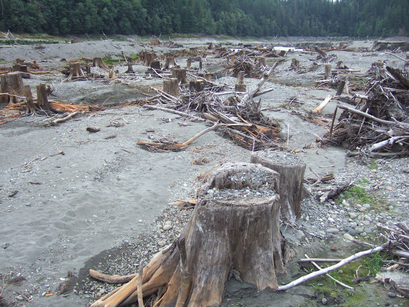
Last week I visited Lake Aldwell on the Olympic Peninsula. Only the lake is gone.
The former Lake Aldwell
No, Washington State is not having a drought like other parts of the United States. Lake Aldwell is no more because the Elwha Dam has been removed.
Former Lake Aldwell
The Elwha River has been set free. First the Elwha Dam has been taken out and the Glines Canyon Dam upstream is being taken down very rapidly.
Former site of the Elwha Dam
This YouTube is an advertisement for boots, but I like the version of the dam removal project and maybe I'll give the work boots a try.
Elwha dams and a rough boundary of the watershed that has been opened for salmon
The removal of the dams opens up the entire Elwha River watershed for salmon. Estimates are that the salmon population on the river will increase to 400,000 fish from the current 3,000. The river extends deep into pristine habitat with the majority of the newly available habitat being with Olympic National Park. timothy Egan has a write opinionator.blogs.nytimes.com/2012/07/26/biological-boomerang. The Elwha Dam removals remind me of some personal history. Back in 2001 the Whatcom County Council had voted on sending a letter supporting the position of not removing dams on the lower Snake River. The Council letter included the line, and I am not kidding, “It is entirely possible that the dams’ net effect on salmon survival is positive”. I was on the Council at the time. Those were the glory days of my elected public service. I voted against sending the letter and kind made a big deal out of the letter. Turns out that line about dams having a net positive effect on salmon was lifted directly from a paper being presented at the time to those that were receptive to the idea that salmon were doing just fine. Besides the line that dams were good for salmon, the paper included “Removal of the dam on the Elwha River has not resulted in any return of salmon to that river”. I wrote an editorial in which I wrote "Mr. ***** (personally I think Mr. **** has suffered enough) is right, salmon have not returned to the Elwha River. Earth to Mr. ****: The dam is still there". A few political foes and friends felt I should have been more conflict adverse. Perhaps so, but I did like the line and the letter had politcal consequences that were favorable from my view.Personal history aside the movement of sediment from the upper part of the former Lake Aldwell was interesting to see.
Elwha cutting into bank of former lake sediment
Exposed stumps exposed by river washing out sediment
(not gravel on top of stumps)
Stump being exposed along bank of newly freed river
Old growth cedar stump exposed on side of cut bank.
Shrinkage cracks within silts
The shrinkage cracks were interesting in that I measured one as being at least 4 feet deep.
A bright future for Elwha salmon
View up the Elwha into the heart of the Olympic Range
Yesterday's field trips were a bit of an extreme range of environments. Forest to industrial.
A particular pleasant forest
One of my favorite views - downtown Seattle from the West Seattle Bridge
No pics of the industrial job site due to work discretion. But a journey through Seattle's industrial/port area is always impressive. The forest of cranes and giant ships and massive transportation infrastructure is a world apart.
"Islands in the sky" is a term applied to the isolated habitats along the mountain top ridges of the Basin and Range of most of Nevada with some adjoining portions of other states. In Washington State there is a similar "island in the sky" habitats on the scattered balds at isolated locations separated by miles of forest land versus the miles of sage and salt brush in the Basin and Range.
Bald area on ridge above Eden Valley
Eden Valley is a valley tucked between ridges on the north side of the Olympic Peninsula west of Port Angeles. I recently ventured into Eden Valley to access a project site. On a sunny day it was very nice and Eden-like. I had a view of one the Eden Valley Balds along the ridge top on the northwest side of the valley as I headed up the valley. These balds provide unique habitat far different than the vast majority of the more typical forested western Washington landscape. Balds are fairly common on the San Juan Islands (balds-praise-for-favorite-washington). But elsewhere such as the Olympic Peninsula balds are more scattered and isolated. In that regard they are rarer and the habitat more critical.
These isolated open areas provide habitat to very specific plants and animals. But unlike the island in the sky areas of Nevada, balds in western Washington are a bit ephemeral. Over time the bald pictured above may be covered by evergreen trees. But the thin soils combined with the location on a ridge allow for the site to be a bit dried out. An occasional, every hundred years or so, a lightning strike may have kept this ridge top tree free. If one looks closely, some of the scattered trees on the ridge are twice as tall as most of the other trees. The tall trees are the survivors of past fires or other disturbances.
These balds are actively being studied as they provide habitat for several rare plant and animal species such as checkerspot butterflies. How to manage these areas is a challenge given the lack of tolerance for wild fires in a commercial forest area or in an area with scattered rural homes. In addition to fire suppression, invasive non native plants that do do perform the same habitat functions can also invade these open areas.
Washington State Fish and Wildlife, Washington State Department of Natural Resources as well as non government organizations have been evaluating different approaches to managing these areas. To some extent these areas are attractive for preservation as the harshness of the environment that causes the balds is not conducive to growing valuable trees.
Another bald on the Olympic Peninsula
My own ventures took me through a mix of timber stands and I enjoyed a snack or red huckleberries within a clear cut before pushing though a stand of 20 year old Douglas fir. The ridge top, however, as can be seen above had tree free areas. The ridge was cliffy and underlain by siltstone and conglomerate bedrock. A review of aerial photographs showed that it burned in the 1980s. This burn area is one of the ephemeral balds on the Olympic Peninsula.
Traversing across the open slopes I had great bedrock exposures - rare treat in this area. I also had some very tasty strawberries. With this year being a bit on the damp side, there is a low risk of fire in this location; however, I noted lots of dry woody material and drought tolerant plants including madrone trees as I neared the ridge crest.
I have been a bit of a road warrior and have been out in the field this week. Some nice ventures but I'll stick with something short and simple for now.
I had my first ride on the Kennewick, the new ferry that is now running between Keystone on Whidbey Island and Port Townsend on the northeast corner of the Olympic Peninsula. As with all the boats in the Washington State Ferry fleet there are pictures associated with the name of the boat scattered about on the walls of the ship.
I went to 8th through 12th grade in Kennewick. Lisa is also from Kennewick and a couple of pictures were therefore close to home so to speak.
Asparagus field at Vancouver and 19th, Kennewick
Asparagus field, Vancouver and 19th, Kennewick
The above is personally fun as it is essentially across the street from Lisa's old home. The pictures sure make asparagus harvest look like fun. But as can be seen it involves lots of bending over. I am not sure it is done by kids as much as it once was. Some of my school mates harvested aspargus in the early morning before school. Asparagus fields were formerly located near where I use to live and Barbara Fouts taught me where asparagus grew wild in the canyon behind our home. That was the limit of my asparagus work.
Pasco-Kennewick Bridge
I did not know that the Old Bridge as we called it was originally called the Yellowstone Trail Bridge. It was named for a trail between Spokane and Walla Walla. A couple of cool things about the bridge. It was built without tax dollars in 1921-1922 and was the first link across the Columbia in Washington State alone. Tolls collected paid off the bridge by 1931. This bridge was a right-of-passage for young drivers: it was very narrow and you had better be good at maintaining a straight drive line when crossing. The bridge was replaced in 1978 by a much wider span. For a about ten years the old bridge remained as there was an effort by a few folks to save it for historic reasons, but those efforts failed and the steel was removed.
The video is very fascinating and a very close call for the news crew as well as resident that lost her home. But that said, the reason the news crew was at the site was an earlier traggic slide.
The landslide/debris flow was on the east side of Kootenay Lake. The lake is in a deep trench like valley with huge mountains rising above the lake shore. The fatalities (assumed at this point in time) were at home sites on what appears to be a elevated glacial terrace well above the stream where the debris flow descended. However, the volume of sediment appeared to have filled the ravine the creek was located in and came up over part of the terrace where homes were located. Difficult to know looking at Google Earth images, but this event may have been the kind with a potential recurrence interval in excess of what geologist often consider.
I have not often done geo hazard work in topography this extreme, but when I do I will mention the difficulty of predicting mountain scale events - the fact is very high steep mountains pose a risk.
Dan McShane is an engineering geologist with Stratum Group, a geology and environmental consulting company based in Bellingham, Washington. Dan has been reading Washington State landscapes since driving across the Horse Heaven Hills with his father and brother in 1970. Dan's wife has started painting Washington landscapes. The intent of this blog is to help all Washington travelers better understand the landscapes we see and share field observations.
Chasing the water
-
At 2 p.m. Monday (Aug 31, 2026) the Albuquerque Bernalillo County Water
Utility Authority, along with the Middle Rio Grande Conservancy District
and Audubo...
References for Clastic Dikes Research
-
Allen, J.R.L., 1982, Sedimentary Structures: Their character and physical
basis, Volume1: Developments in Sedimentology 30A, Elsevier, 592 pgs.
Allison, I....
Statement on ISW Methodology
-
*Statement on ISW Methodology*
*May 4, 2023*
The Institute for the Study of War (ISW) welcomes robust and rigorous
debate on the issues ISW covers and i...