Saturday, June 9, 2012

Borderlines and the Oregon Country: Whatcom County Sheriff Nearly Starts a War with Great Britain

…. the line of the boundary between the territories of the United States and those of Her Britannic Majesty shall be continued westward along the said 49th parallel of north latitude to the middle of the channel which separates the continent from Vancouver’s Island; and thence southerly through the middle of said channel, and of Fuca’s Straits to the Pacific Ocean… - The Oregon Treaty of 1846 between Great Britain and the Untied States.

For the most part the dispute over the Pacific Northwest was resolved with the Oregon Treaty; however, a new dispute soon arose over just exactly how the boundary would traverse through the waters separating the main land from Vancouver Island. This dispute had some interesting twists and if one finger had been a little quick with a trigger the outcome of the US Civil War may have been a bit different.


San Juan Islands parked smack dab in the middle.
Where would you draw the border?

Between Vancouver Island and the mainland lies a broad archipelago of islands. Some of these islands had significant agricultural value at the time. While much of area of what is now northwest Washington and southeastern British Columbia was heavily forested, large swaths of the islands between the mainland and Vancouver Island were prairie and covered with grass lands. At the time of the Oregon Treaty these lands were ideal pasture land for sheep. The sheep provided wool for clothing and cloth valuable to local residences and for trading for other goods. The Hudson Bay Company already firmly established at the southeast end of Vancouver Island at present day Victoria began agricultural operations in parts of the San Juan Islands shortly after the Oregon Treaty was signed.

It should be noted that for the British citizens of the area there was strong resentment that the border was at the 49th parallel and that Britain had given over the Puget Sound region. Great Britain and the US both claimed the San Juans. It took some time for the dispute to heat up but Whatcom County played a role. The Oregon Territory was split into two territories in 1853 with Oregon Territory being the southern half and the new Washington Territory being the northern half. At that time Whatcom County covered all of northwest Washington and given that the US claimed the San Juan Islands, Whatcom County included the San Juans on the County tax roles. In 1855 Whatcom County assessed the Hudson Bay Company properties in the San Juans and when the tax was not paid foreclosed on the property and announced a sale of the land (and sheep) for tax foreclosure purposes. Of course the Hudson Bay Company ignored the position of the County. Then the Whatcom County Sheriff landed on San Juan Island at night and rounded up sheep for a midnight sale to other Whatcom citizens. They were caught doing this. It is a remarkable thing that no shots were fired and was was avoided. If war had broken out between Great Britain and the U.S. in 1855, it is hard to imagine the U.S. Civil War taking place the way it did.

A Boundary Commission was set up in 1856 to try to resolve the conflict, but the Commission meetings ended with the San Juan Islands still in dispute. England claimed the boundary was Rosario Strait on the east side of the islands and the US claimed it was Haro Strait on the west side of the islands. A last gasp compromise that offered San Juan Island as well as a few other more western islands being used by Hudson Bay Company to England was rejected by the English contingent.

With both American and Great Britain claiming the islands the conflict continued to simmer. The San Juans were a neutral zone where the law was not clear. With both English and American citizens claiming and setting up farms, the San Juan Islands were off to a lawless start. The islands were a great place to import wool through as well as other items in order to avoid duty fees. However, it did not take long for conflict to arise with the Pig War in 1859.  And unlike the conflict with the Whatcom County Sheriff, both the English and Americans had troops and gun ships aligned against one another. Remarkably the conflict was resolved without blood shed (except for the pig). A cool headed British commander declined to force the issue and no one fired the first shot. Again the trajectory of the Civil War may well have been determined by what sounds like a light funny incident at first read.

A joint military occupancy was set up in 1859 and continued through the US Civil War and to 1872. At that point Great Britain and the US agreed to send the conflict to arbitration. The powers in Washington DC and London thought better of going to war over a small set of rocky islands. An additional conflict was also in the mix with U.S. claims against Great Britain regarding Britain aiding the Confederacy during the Civil War via the building of a war ship, the Alabama. The arbitrator was Kaiser Wilhelm of Germany. Wilhelm set up a 3 person panel to hear evidence and make a recommendation. The panel listened to presentations made by the Americans and English that utilized navigational charts made by Wilkes in the 1840s and Vancouver in the 1790s to determine how to draw the line from the Strait of Georgia to the Strait of Juan de Fuca and separate Vancouver Island from the Continent.

So back to the map. In our case we have a nice satellite image. The panel had the best maps of the day, but they were a bit tougher to decipher.


Vancouver's 1798 map
So where would you draw the line? Where is the middle of the channel that separates the continent from Vancouver Island? Of course today the deabte would go a bit differently because geologists would have tesitified that Vancouver Island is now part of the North American Continent. Wilhelm's panel split 2-1 in their recommendation and Wilhelm went with majority setting the line down Haro Strait on the west side of the islands giving a future Washington State tourist mecca to the United States.

As for Whatcom County's jurisdiction over the San Juans. That ended with the clarification that the islands were part of the U.S. and a new county was formed - San Juan County. I have to wonder how things would have turned out if the night of sheep round up on San Juan Island someone got shot.

Thursday, June 7, 2012

Tent Caterpillar Perspective

A few summers ago I was working in the forest on the northwest Olympic Peninsula and thought it odd that even though it was late June, the red alders were leafless. On closer inspection I realized that they had been stripped of leaves by caterpillars.

Marian Edain of Frosty Hollow Ecological Services had a write up at part of the Whidbey Environmental Action Network that provides a bigger picture perspective.


Tent Dwellers of the Northwest Woods

Once upon a time there were ancient forests of enormous Douglas firs and Western red cedars in the Puget Trough. There were Red alder present near streams and wetlands, and in the openings where the occasional giant tree came crashing down, but they were not particularly common. One of the species native to these forests was the tent caterpillar. It ate mostly Red alder leaves and converted the vegetation into compact packets of fairly intense fertilizer. Those packets (the polite term is “frass”) provided a shot of nutrients to the surrounding conifers. Good system.

           Then white folks settled the area and cut down the conifer forests. Nature abhors a vacuum and filled a lot of that bare ground with a band-aid: the quick growing Red alder. We ended up with large areas of alder where formerly there had been conifer forest. Given enough time (say 50+ years), Douglas firs would grow up among the alders, top out over them, and slowly shade out the shorter lived alders. Tent caterpillars, which had formerly been a pretty small component of the forest system, took advantage of those large areas of alder to explode their population. The exploding population ate the leaves off the alders, which allowed sunlight down to the forest floor where the little Doug firs were struggling along, at the same time as it delivered a great big jolt of fertilizer in the form of all those frass pellets. Even with the system out of kilter, the tent caterpillars were performing a very useful re-balancing service. And because they only produce one generation per year, they rarely actually killed any trees. They came, they went, and the trees produced another set of leaves.

           The only fly in this ointment is that the tent caterpillars also like to munch on almost everything in the rose family - like your apple, cherry, plum, peach, apricot, and pear trees. A lot of people want things all neat and clean, and they reach for the pesticide spray to kill those nasty tent caterpillars. Not good. Counterproductive. Does more harm than good.

           The caterpillars go through 5 stages called ‘instars.’ When they first hatch out they form those lovely tents in the trees. As they go through the stages they wander farther and farther from the tent in search of leaves. Eventually they migrate down the trunk of the tree where they were hatched and search for another high place where they will pupate. That will produce a brown moth who will lay eggs which look like a blob of grey styrofoam wrapped around a stem, and the whole process will begin again next year.

           There are several things which nature does to control the caterpillars without any help from us. The most useful is a virus (Polyhedrosis). One day the world is crawling with caterpillars. The next day all you see are dead bodies draped all over the trees. And that’s the end of the invasion. The other thing you see is bright white spots, usually on the forehead of the caterpillar. This is the egg of a wasp (kids love this part). The egg hatches and the larva burrows into the caterpillar where it eats it from the inside out. By the time it is ready to  emerge there’s just the shell of a caterpillar. When you pick up a tent caterpillar it will whip its head back and forth. This is its way of trying to avoid the wasp laying an egg on its head.

           In most cases the caterpillars cannot kill your trees so the thing to do is nothing. If you really can’t stand them, the best thing to do is to use plain old water. Get one of those nozzles that makes your hose act like a fire hose and just hit those tents. The spray should knock them out of the tree. If you feel vindictive, you can then pick up the tents and burn them, but you really don’t need to because you’ve destroyed the caterpillars’ home and they don’t know what to do next. If you have a particularly vulnerable young tree, you might want to wrap the trunk with cloth on which you then smear sticky stuff (you can buy this at the garden store). Just remember to remove the cloth after the caterpillars are gone.

           Bottom line: the tent caterpillars are working to re-balance our out of balance ecosystem. They don’t know when to stop, so just hose them out of your fruit trees.
No need for any toxics.

Wednesday, June 6, 2012

Borderlines and the Oregon Country

I've been enjoying Frank Jacob's borderlines. As someone that pours over maps of all kinds I very much enjoy reading about how various obscure borders.
Jacobs wrote a recent post on neutral zones http://opinionator.blogs.nytimes.com/2012/05/01/put-it-in-neutral/#more-127593. To a degree, Washington State was once part of a hybrid neutral zone. At one point in the early 1800s Spain, Russia, England and the United States all had claims on the territory of what is now Washington, Oregon, Idaho and British Columbia. The Spanish and Russians gave up their claims as neither established any sort of presence in the area, but both England and the United States continued to claim the Oregon County as the Pacific Northwest was called with England very firmly established via the Hudson Bay Company and America via Lewis and Clark and some very tenuous American fur trading efforts.

With an uncertain and competing claims, a joint occupancy agreement was made between the two countries in 1818 and again in 1827. Not a bad alternative after the War of 1812 between the two nations. Citizens from both countries lived and worked in the contested territory. For English subjects, governance was carried out by the Hudson Bay Company. In cases of criminal misconduct the accused was taken to the nearest permanent English settlement for trial. But for Americans, the Oregon Country was lawless with law taken into their own hands and essentially no government at all.

And never mind that an entire other group of people had already been living in the Pacific Northwest for thousands of years with their own way of governing and enforcing laws and codes of conduct. The First Peoples had their own territorial disputes and fluid borders as well. Initially there were very few Americans; it is remarkable that America was able to hold on to the claim of the area at all. But in the late 1830s a trickle of settlers began to arrive and by the early 1840s the Willamette Valley was becoming American with little regard for the initial inhabitants.

In 1846 the question of the which nation controlled the Oregon Territory was settled with the Oregon Treaty. A very simple solution that continued the border along the 49th parallel with an allowance for the very English presence firmly established on the south end of Vancouver Island deviating from the 49th Parallel.

Original American Oregon Territory after the Oregon Treaty

The southern border of the territory followed the former northern Spanish claim that had been ceded to the US from Mexico following the Mexican-American War. The eastern boundary was the crest of the continental divide.

While there was significant presence of Americans in what is today Oregon, there were very few in what is now Washington. England pushed for the boundary to be at the Columbia River, but the 49th parallel prevailed. For England the area between the 49th and the Columbia was not worth going to war over and at the time the territory was not a big money maker. Charles Wilkes' report greatly influenced the American view to included the Puget Sound Country. Wilkes was to sail up the Columbia River, but decided the Columbia was a terrible west coast port due to the horrific waves at the river's entrance. His report strongly argued for acquisition of the Puget Sound for shipping purposes.  

Tuesday, June 5, 2012

A Land Shaped by Subduction

A couple of winters ago I was working out on the Olympic Peninsula and noted that the wind was from the east, but it was not an Arctic outflow event. Perfect weather for a trip to the outer coast. I drove out to Neah Bay and the Makah Reservation. I noticed that the town of Neah Bay and the low estuary land that extends between the the town and the open Pacific Ocean. Brian Atwater came to Neah Bay in the 1980s to look for evidence of tectonic coastal subsidence. Within this low land area he began to gather evidence of large subduction earthquakes on the outer Washington coast as well as tsunami evidence. It crossed my mind that the current Makah village was likely located in an area that will be severely damaged during the next big subduction quake.

The following winter I took another trip to the outer coast further south. This time I took my inflatable kayak and paddled up a couple of estuaries. At one location I observed sandy tsunami deposits over black organic soil and at one location over what I interpreted to be a fire pit and other indications of past human habitation.

The great subduction earthquake of 1700 must have killed many coastal people. The stories of that event survived and were passed down to later generations. The event must have greatly altered coastal societies with entire communities destroyed and dislocated. The event impacted hundreds of miles of coast line from British Columbia to northern California.

I have speculated that the history of Washington State and the Pacific Northwest may have evolved very differently if the first European contacts had not come so soon after the disruption of the 1700 tsunami. A paper by Leland Gilsen (Gilsen, 2002) lays out a framework for further research and context. The subduction zone along Washington's outer coast has shaped not only the land but the population curves and societal interactions. And it will continue to do so. 

Sunday, June 3, 2012

Another Coal Terminal Issue

Selendang in trouble at Unimak Pass, Alaska
(Alaska Department of Environmental Conservation) 

Coal terminals have become a big issue in Washington State and the entire Pacific Northwest. For opponents of the coal shipping terminals scoping is the buzz word. That is when considering the various terminal proposals, What should the scope of the environmental review include? The list of issues and whether they are included in the environmental review is a key point of decision for the viability of the various terminal schemes and what will require mitigation and what will be allowed with no consideration. Beyond the local impacts of simply constructing a coal terminal other issues to be assessed may include rail traffic impacts due to the increase of rail traffic impacting other shipping and roads from Billings, Montana to Cherry Point, Washington, air quality along the rail route, mining impacts and CO2 impacts. The coal terminal proponents likely will resist having these issues included in the review and opponents will likely strongly push to have these issues included.

Frequently environmental impact statement scoping is a snooze with not a great deal of attention beyond a few agency folks. The last one I was directly involved with had no one from the public show up. Others have what could be termed the usual suspects participating. A pre scoping meeting in Bellingham just to inform the public about how scoping for the Cherry Point coal terminal will proceed had over 800 people show up.

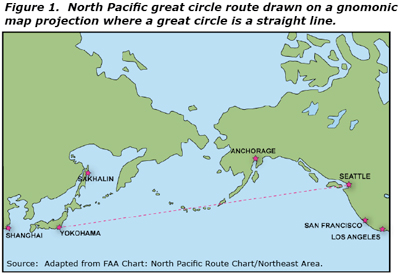
This past week I learned about a new issue thanks to Barry. Perhaps that is why scoping hearings are so important. Someone will show up an raise an issue no one had thought about - say the great circle route large bulk coal ships will follow through the Aleutian Islands and the risks associated with this narrow ship passage. http://www.aleutiansriskassessment.com/documents/060922AleutiansVesselReportSCREEN.pdf


Saturday, June 2, 2012

Lake Whatcom Reconveyance

As noted previously, the Whatcom County Council voted to move forward with the Lake Whatcom reconveyance creating a 8,700 acre County Forest Preserve Park in the Lake Whatcom watershed. For local Whatcomcentric folks reconveyance has become familiar. It is an idea that has been a local policy issue for sometime. What follows is a summary history of the Lake Whatcom Reconveyance and an editorial note at the end.

What is Reconveyance?

Reconveyance applies only to forest board lands. Forest board lands were created after cut and run logging operations in the early 1900s left hundreds of thousands of acres of cut over land that county governments had foreclosed on due to failure to pay property taxes. This type of forestry had happened in other states as well. In Washington State questionable homesteading and corrupt land give-a-ways by local Government Land Offices allowed large swaths of timber land to be available for harvest with little regard for long term management. Throw in boom and bust economic cycles and the result was a wasted landscape subject to fire and slow forest recovery. Giffird Pinchot and Theodore Roosevelt had predicted this would happen in the west and moved to better manage the western forests by creating National Forests. 

By the 1920s and 1930s large swaths of cut over land in tax foreclosure covered hundreds of thousands of acres. County governments did not have the capacity to deal with these lands so the State stepped in and took over management of these lands. This management added to the already large tracts of State owned State Trust Lands that were ceded to the State by the Federal government at Statehood. Management was needed to get the land reforested and manged for fire. One county, Grays Harbor County, was allowed to opt out of the program. Grays Harbor County manages their own county forest board lands.

Although lumped together with the State Trust lands, the Forest Board Lands are not the same. Local counties can have the lands reconveyed back to County management, but only for park purposes. Hence, the term reconveyance. The land that is reconveyed goes from State management to County management.

1983

Early January 1983 is a stand out date for Lake Whatcom, forest practices in Washington State and geology. An intense storm event focused an atmospheric river of water into the Northwest Cascades. At numerous locations throughout the range but with a particular focus on the steep mountain slopes above Lake Whatcom, the South Fork Nooksack River, and Samish River old logging roads collapsed, culverts on logging roads plugged and dozens of debris flows descended down the steep drainages. In the Lake Whatcom watershed Smith Creek, Carpenter Creek, Olsen Creek, Blue Canyon Creek, Austins Creek as well as several unnamed streams blew out sending debris flows down on to the alluvial fans below and into the lake. County roads were damaged, bridges were destroyed, homes crushed, properties buried in logs and mud. A woman woke up found her house was floating in the lake.

After the slides it was clear that the majority of slides were the result of poorly constructed logging roads and poor logging road drainage. Public opinion toward forest practices shifted very hard against the industry. Legal actions took place, most were settled before trial. Forest practice standards were improved. Particular attention was directed at logging road construction methods, logging road stream crossings and how roads were maintained and what to do about old abandoned roads. And keep in mind that this was before fisheries impacts needed to be better accounted for.

Lake Whatcom Land Exchange

Lake Whatcom is the drinking water source for approximately half of the residences of Whatcom County. After the slides the Whatcom County government expressed an interest in getting the lands under public ownership. This purpose was two-fold: 1) it was felt that the state would manage the lands better than private timber companies thus reducing the risk of debris flows and damage to the lake and 2) getting the land into public ownership would reduce the risk that lands would be developed.

The County entered into an agreement with the State Department of Natural Resources where the County paid the costs associated with the State exchanging forest board lands with private forest holdings in the Lake Whatcom watershed as well as some other sites within the Chuckanut Range south of Bellingham. The State Board of Natural Resources with encouragement from the Department of Natural Resources approved the exchange. For DNR, it allowed for larger blocks of land to be consolidated for easier management not only in the Lake Whatcom watershed but also in other areas. Part of the agreement between the County and State was that a forest management plan specific to Lake Whatcom would be developed. This agreement and the exchange took place in the early 1990s. 

The First Forestry Plan for Lake Whatcom

While there was an agreement between Whatcom County and the Department of Natural Resources to develop a forest management plan for Lake Whatcom together, such planning never took place. In my view this was not really the fault of the DNR. The DNR did develop a watershed analysis with specific prescriptions for timber harvests on the State managed lands in the watershed. Watershed analysis does have a public component. For whatever reason once the land exchange had taken place the county paid little attention and never participated in the watershed analysis process. Nor did the City of Bellingham.

In 1997 the DNR began conducting timber harvests in the watershed using the adopted watershed analysis. Except for a few minor private timber harvests in the watershed, there had been little forestry activity in the watershed since 1983. Hence, there was a strong public reaction to the renewal of large scale timber harvests. At that point the DNR attempted to do public out reach to alleviate concerns. I will note that I attended one of those meetings and will say that I felt a bit bad for the DNR. Up until actual harvests began, the local residences, County government and city government had paid little attention to the management planning.

Development of the Second Lake Whatcom Forestry Plan

Issues regarding water quality in Lake Whatcom had evolved significantly since the land exchange had taken place. There was a growing awareness that the lake water quality was in decline. That decline was primarily the result of Bellingham allowing nearly complete urbanization of the north end of the lake where the north basin of the lake is shallow and very sensitive to phosphorus loading. The second basin in the lake under county jurisdiction had also had significant residential development and it too was showing declines in water quality. And though most of the damage was at the north end of the lake, the entire lake was becoming impacted.

Hence, forestry on public lands by the DNR was not well received in the local community. The question of whether additional protections should be applied on the public lands in the watershed was raised. The DNR said no - that watershed analysis was enough.

A few community members thought differently. Linda Marron and Jamie Berg began an effort to require the DNR to place greater protection within the Lake Whatcom watershed. This required a change in State law. No small task, but with support from Conservation Northwest and local State Legislators Keli Linnville, Harriot Spanel and Doug Ericksen (Ericksen added a key amendment to one of the bills) as well as Jim Buck from the Olympic Peninsula, the State Legislature passed a two bills requiring the DNR to develop a specific Lake Whatcom Landscape Plan. In the mean time no timber harvests were allowed with the watershed on public land.

A committee was formed to assist the DNR in development of the plan and the plan went through a lengthy Environmental Impact Statement process. The Lake Whatcom Landscape Plan did go beyond the typical forest practice rules and built on the previous watershed analysis. The primary differences between the Lake Whatcom Landscape Plan and standard forest practices are 1) road construction is not allowed across unstable slopes and 2) All streams including ephemeral drainages must be buffered from harvest. There are other differences as well, but in the big picture these two were the biggest differences and deviate the most from standard forest practices.

The New Plan and New Concerns

The Committee and the DNR completed work on the Lake Whatcom Landscape Plan in January 2004. The Board of Natural Resources received the plan and were scheduled to vote on the plan in April 2004. The Board punted and took no action. The Board really did not like the plan. They did not like the fact that the State Legislatures had dictated new forest practice rules specific to a single watershed. They did not like the impacts to trust land revenue generation. They did not like the additional management costs.

Months went by with no action. Letters from Whatcom County were misinterpreted. State politics and posturing had frozen the adoption of the plan. In October 2004 Whatcom County filed a lawsuit in Thurston County Superior Court against the Board of Natural Resources and the Department of Natural Resources. At the next Board meeting the Board of Natural Resources passed the Lake Whatcom Landscape Plan.

The Lake Whatcom Reconveyance Concept

Adoption of the landscape plan raised some fundamental questions regarding forest management and trust revenue issues for Whatcom County, the DNR and the Board of Natural Resources. The final steps for adoption were a bit bruising. The adoption of the Landscape Plan was not the end of the process. Threats to the landscape plan were multiple:

1) In adopting the Landscape Plan, the Board added extensive language regarding assessing the plan and reporting on the plan that clearly stated an intent to end the plan. One reason the County filed the lawsuit was language in a DNR proposed resolution to the Board that would establish an end date to the plan.

2) The Board of Natural Resources gave clear direction for the DNR to explore options to end following the plan.

3) Skagit County and the Mount Baker School District filed a lawsuit in an attempt to have the plan over turned. This lawsuit was supported by timber industry folks as well as other counties.

4) Briefings filed by the State in defense of the Plan were such that it was very unlikely that the State would defend the plan. Perhaps most telling - during initial arguments the State attorney sat at the same table as the attorney bringing the lawsuit against the State while intervening attorneys sat at a separate table.

5) DNR staff began an active lobby effort to attempt to get the State Legislature to pass legislation dismantling the Plan

6) DNR staff started negotiations with at least on private timber company to exchange forests trust lands out of the watershed.

With these various threats against the protections required by Landscape Plan, Whatcom County began considering taking over management of these lands as a large forest reserve park. The County could have simply requested reconveyance at that time, but decided that the best approach would be to do an additional land exchange between the various State Trust lands in the watershed and the Forest Board lands in the watershed with the idea that a blocking up the Forest Board lands as a coherent block and the State Trust lands as a coherent block would make better sense for management of the forest preserve park and State Trust lands.

Steps Towards Reconveyance

The County passed a budget line item to fund the process of an intertrust transfer in late 2006. In late 2007 the DNR and the County reached an agreement to work together on the trust land transfers. A final agreement between the DNR and Whatcom County was approved in early 2008. It took until 2010 before a final contract approving the work necessary was approved by the County Council.

The needed assessments of timber value and surveys were completed in 2011 and the proposed intertrust exchange was presented to the Board of Natural Resources in October 2011. The Board .... punted (washington-state-board-of-natural). The Board wanted to know if Whatcom County really still wanted to complete the reconveyance.

Yes, Whatcom County Really Wants a Park

In late May of 2012 the Whatcom County Council voted 5-2 whatcom-county-council-moves-forward to send a letter to the Board of Natural Resources essentially saying that yes, Whatcom County wants to take over management of the County Forest Board Lands in the Lake Whatcom watershed.

One of the potential snags in support for the park involved the Mount Baker School District. There was an issue of lost revenue to the school district. The loss was frequently was presented as a much larger loss that it really is, but regardless the County Council felt a fair bit of sympathy to this rural school district. The problem for the County was there was no means to gift money to the district. Whatcom Land Trust stepped in and arranged an anonymous donation to the District that far exceeds the forest revenue the District would have received and can be utilized in a much more flexible manner. This generous contribution won over the District's support for the park.

The Last Steps

The issue now will go before the Board of Natural Resources - likely in July. The Board has an option to approve or not approve the intertrust transfer between Forest Board lands and State Trust lands. Once the exchange is approved the Board must approve the Reconveyance.

Editorial Note

I tried to present this history in a fairly neutral manner. But anyone that has followed this would never really believe what I presented as neutral. I first became involved in public lands forestry issues in 1998 when I was asked by Linda Marron and Jamie Berg to review a forest road proposal by the DNR. I wrote a report on that proposal and testified at the State Legislature hearings on the Lake Whatcom bills. I also served on the Lake Whatcom Landscape Committee. My interpretations of the various threats to the Landscape Plan presented above led me to believe that the best solution to public forest land management in the Lake Whatcom watershed was reconveyance.

I whole heartily supported the Reconveyance and express great appreciation to those that supported this idea and have brought it so far forward with particular mention to:

Jamie Berg and Linda Marron who would not let an issue go;

Conservation Northwest that provided technical support throughout with particular efforts by Lisa McShane, Mitch Friedman and Seth Cool;

Dewey Desler, Whatcom County Administrator who reacted with great enthusiasm to the idea when it was first suggested;

Pete Kremen, Whatcom County Executive and then later County Council person steadfastly supported the Landscape Plan and then put all his political efforts into supporting the park plan;

Mike McFarlane, Whatcom County Parks Director managed the transfer process and park planning to perfection and became the best possible authoritative spokesman for the park;

Whatcom Land Trust and Rand Jack as well as the anonymous donor, they stepped up and resolved the issue of revenue concerns at the Mount Bake School District;

Laurie Caskey-Schriber, Carl Weimer and Seth Fleetwod, Whatcom County Council members that supported the Park idea from the very beginning in 2006 - the park would never have moved forward without their unhesitating support;

Ken Mann, Whatcom Council supported moving forward with the park throughout his tenure on the Council

And lastly and in a way the most satisfying: Sam Crawford and Kathy Kershner, Whatcom County Council members. Both supported moving forward with the contract for the intertrust exchange and in a way Kathy Kershner said it as well as anyone when she voted for the park “It’s going to be a beautiful place for generations that will come after us to go to and recreate,” she said, “and I think that’s important that we sometimes do things just because it’s a beautiful area and we want to keep it that way.”  

Friday, June 1, 2012

The Old Landscape Before Urbanization

Not all of my field work is glorious view scapes. Yesterday I was in one of Washington's larger urban cities exploring the geology landscape under an old building when I came across this:

Cedar stump

I've encountered organic material under old foundations before, but an old growth stump was a first. The stump measured 6 feet across.