Monday, February 6, 2023

Asio flammeus on Samish Flats

The Skagit Flats and Samish Flats is birding destination. There are plenty of wintering birds that attract the birders, but the short eared owls are particularly cooperative for observation along Bayview-Edison Road near the mouth of the Samish River into Samish Bay. Besides getting to see them in close flight, the owls have taken to perching on the top of the Fish and Wildlife signs within 60 feet or so from the road regardless of the crowd. On a recent mild sunny day the line of people and cars along the road stretched several hundred meters. The short ear owl is not rare, but their habit of hunting during light allows for much easier viewing than the more nocturnal owls.  


Sunday, January 22, 2023

Winter Field Work

I have developed a preference for geology field work in the winter. Geology field work in western Washington State is generally pretty easy. The hardest challenge in western Washington is the thick vegetation. If you do not like smashing through brush, western Washington off trail field work is not the place for you. In the winter the vegetation is less dense with leaves off of the deciduous trees and bushes. However, Himalayan blackberries with their long canes and thorns still present a problem. On a recent excursion to a slide complex my initial thought was navigating on the slide complex might be limited due to the thick blackberry growth over much of the slide area. However, as I made my way onto the slide I realized the mid December heavy snow followed by freezing rain at the site had flattened down the much of the blackberries making my traverses on the slide complex much easier than initially anticipated. 

I still had to high step a bit to get over the blackberries but it was much easier than if done at another time of year. 

I caught another break with winter weather making my traverse easier after a couple of days steady temperatures well below freezing and before a big snow. I muddy slog with mid shin water and muck. I had been across the same area before. Though the site looked very wet the freeze allowed for easy walking across the frozen mud and frozen ponded water.

The weather does not always work out but, there are the other added benefits: no bugs, easier to see where water has been flowing, and not much worry about dehydration.    


Wednesday, January 18, 2023

The Penn Cove Whale Watchers

Many of my shore walks to visit slides and bluffs are non social events. I most often do not see anyone particularly on chilly breezy day in winter. But on this trip on southeast corner of Penn Cove on Whidbey Island I came across a group with long camera lenses. Their aim was well out in the water beyond my ability to see with my own eyes and out of my field point and shoot camera.  

The whale watchers looking out over Saratoga Passage with 
Camano Island across the water and Mount Baker and Twin Sisters in the distance

 The group was tracking a pod of Orcas and with their lenses were able to identify specific wales by their dorsal fins. 

Penn Cove was the location of a rather notorious Orca capture in the early 1970s when Orcas were herded into Penn Cove and young Orcas were taken from the pod and at least 5 Orcas died. 

Sunday, January 15, 2023

Sea Level Rise: Notes on the December 27, 2022 Tide Flood

Back in mid December I visited a dike on the distal Skagit River delta area near Samish Island. The dike holds back high tides from Alice Bay from inundating the low farm fields and road. My site visit took place during high tide. During low tides Alice Bay typically fully drains becoming a broad mud flat.  

Samish Island Road and the dike between the road and Alice Bay.
The road is below sea level

View of the dike looking north. Alice Bay on the right, the east end of Samish Island is in the distance and the Chuckanut Range in the far distance 

View looking south along the dike.
Grassy areas in the near distance are saltwater marsh.

Dike District 5 portion of dike. This section of dike was and lined with with rock last year.

Last February there was a tide surge that caused tidal flooding in Edison. The minimal free board and dike erosion resulted in significant dike raising by the District. However, the district boundary ends between the above shown new work and the high ground to the north at Samish Island.

On December 27, 2022 a very deep and broad area low pressure storm system combined with very high astronomical high tide. The low pressure path and associated wind pattern added to the water levels. At Port Townsend the storm tidal surge was 2.5 feet.


    The result was water overtopping the dikes shown  above. 

Sea water over topping the a low spot in the dike

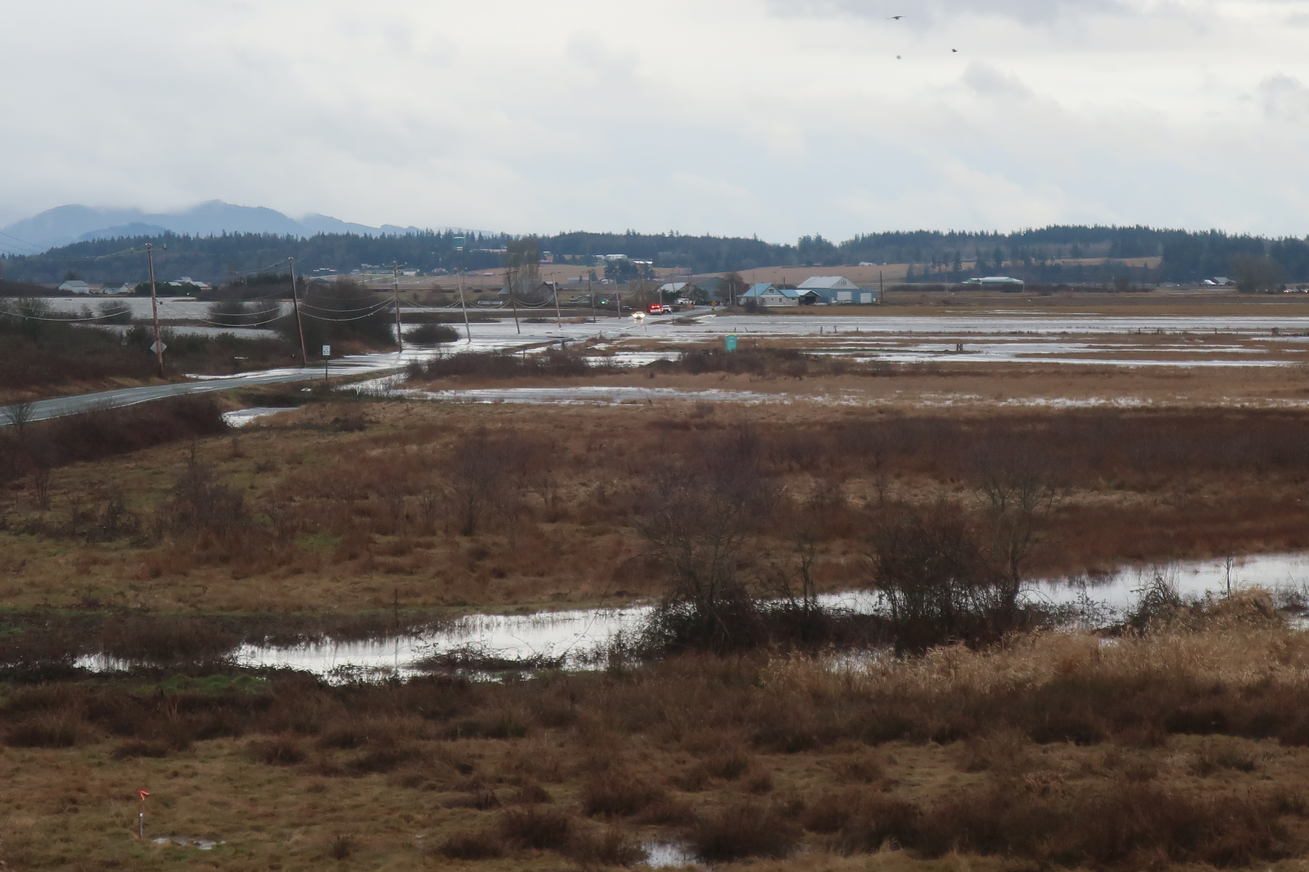
Multiple over flow locations along dike and water filling the low area behind dike including the road

Tide flood water pouring across road into fields to the west.

Flooded fields viewed from the north

While the above shown flooding covered on the order of 150 acres of fields with sea water, the impact for other areas was more acute. Flooding was reported at multiple locations from this event including Olympia and Port Townsend. 

North shore of Samish Island looking east.
Note that water just reached the top of the slightly elevated area between the homes and Samish Bay.

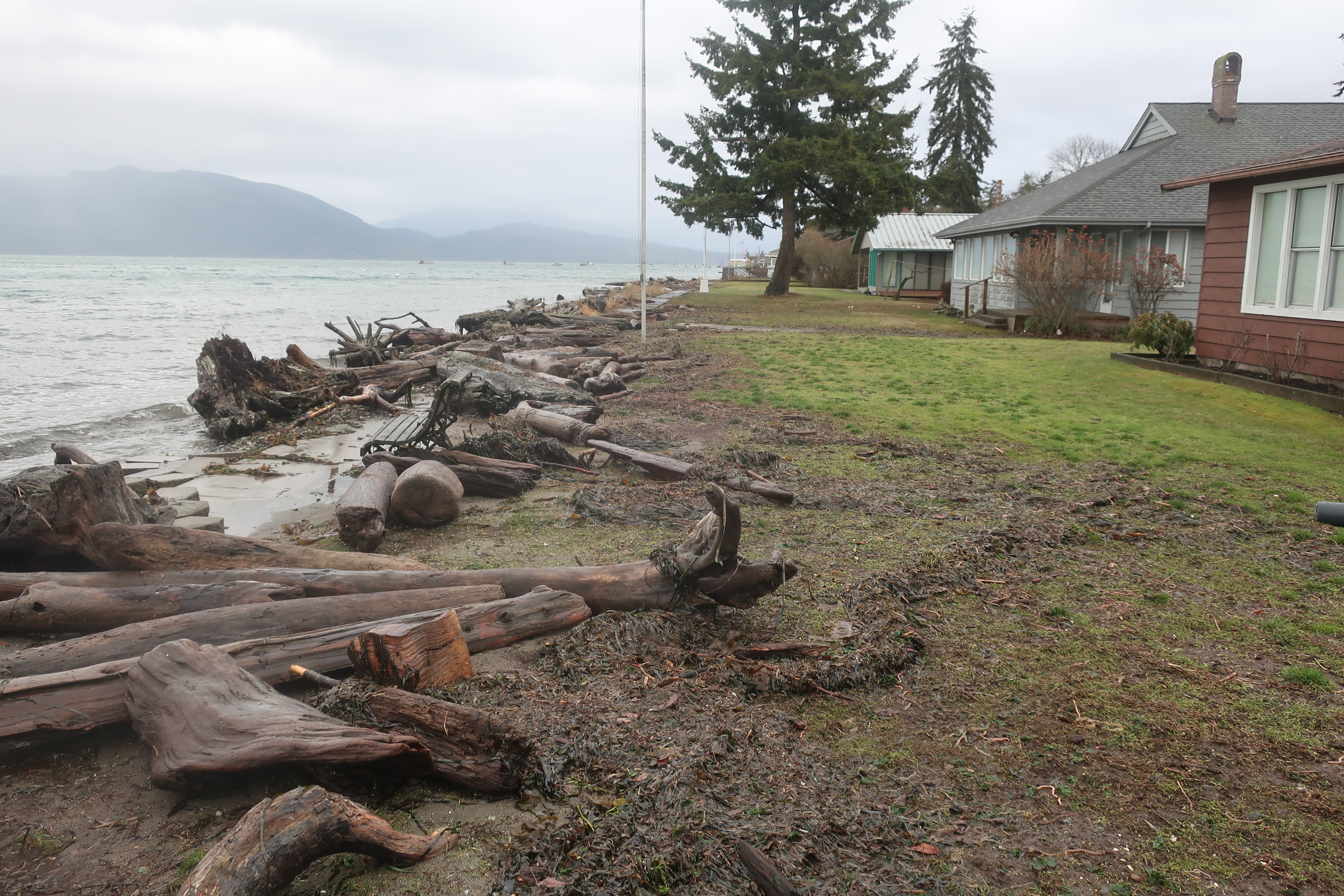
From the same location above but looking west.
Note here that the berm between the homes and bay is lower allowing flood waters to reach the homes.

Water getting over or around the elevated shoreline berm flooded the whole low area behind the berm. I had some work to do at this area and the water over topped my rubber boots. Not particularly pleasant as the flooding included flooding all the septic systems.  


Sea level rise is pushing what in the past had been a close call tidal flood to full out flood events with a higher frequency. 

Friday, December 23, 2022

Notes on Sweet and others (2022) Seal Level Rise

Earlier this year Sweet and others(2022) updated Sweet and others (2017): Global and Regional Sea Level Rise Scenarios for the United State. Sweet and others (2017) suggested global sea level (GMSL) will rise as between 0.3 meters and 2.5 meters by 2100. Sweet and others (2022) find the high end of 2.5 m by 2100 less plausible. The bad news is that the rate of GMSL rise has been increasing and Sweet and others (2022) project that the rise in GMSL over the next 30 years will be as much as that over the past 100 years. The 2022 report notes a high level in confidence for their sea level rise scenarios over the next 30 years. Post 30 years the confidence level for sea levels is lower primarily because of uncertainty regarding some of the ice sheets in Greenland and Antarctica.  

GMSL is not simple and the sea level rise is not uniform around the planet. Some places will see greater sea level rise and others less. The 2017 report included an image of global sea level rise from 1992 to 2016 derived from satellite data measurements. 


Figure from Sweet and others (2017)

Global sea level has rises in an uneven manner due to currents, warm water expansion, and changes to gravity fields from more water in the oceans (the Earth's surface is flexible). The sea level also can vary due to cyclical climate patterns that move the ocean water around via wind and temperature patterns. I like to think that the ocean layer as having weather only slower and a bit less pronounced than the atmosphere. The image above also shows that on the Washington State coast the global sea level trend was near neutral for the 1992-2016 time period.

The 2022 report has an image with three plots showing global sea level rise along the coast of North America. 


Figure 2.1 from Sweet and others (2022) Regional sea level linear rates of rise (mm/year) from satellite altimetry over three different time periods: (a) 1993–2006, (b) 2007–2020, and (c) 1993–2020. Linear rates of change of relative sea level (ocean and land height changes) from tide gauges over the same time period are also shown (circles). 

For Washington State the 1993 to 2006 period the regional sea level rise was mostly neutral, but the more recent period of 2007 to 2020 shows that regional sea level on the Washington coast has increased as has the regional rates in most places around North America. 

The global and regional sea level increase is not a simple uniform rise. There is an added complexity: while regional sea level is changing, the land next to the sea is also changing in level. More on that on a future soon post.


Sunday, December 18, 2022

The Two Hat Islands in Washington State

I visited Hat Island in Possession Sound west of Everett this week. The icy thick fog in the morning prevented a good picture of the island, but but I had a nice view from the island. 

View from a high bluff on Hat Island looking south to the Mukilteo Ferry and Whidbey Island coast

Just the week before I had a nice view of Hat Island in Padilla Bay east of Anacortes. 

Hat Island viewed from the west in Guemes Channel 

How can there be two Hat Islands in the same state?  

If one zooms in on the USGS National Map the Possession Sound Hat Island has two names.  


I have always thought of the island in Possession Sound as Hat Island. The community of homes and lots on the island is called Hat Island and the ferry (private) is the Hat Island Ferry. However, its official name on the USGS topographic map is Gedney Island. The name was given to the island by Wilkes following a common custom of the time of the random naming things for associates or friends that never came near the area. Waterman (2017) provides some background on Gedney and his role in the La Amistad case. Gedney's claims on the La Amistad and it cargo may explain why locals preferred using the name Hat Island. 

The Hat Island in Padilla Bay is a Washington State Natural Resource Conservation Area. Perhaps an official name change is in order for one or both of the Hats.      

Monday, October 24, 2022

Mary McCaslin - Prairie In The Sky

Mary McCaslin died earlier this month (nytimes./music/mary-mccaslin). Mary McCaslin wrote and sang a number of songs that always stuck with me - enough so that I could sing them through myself years after. Prairie in the Sky still resonates. I believe Mary and I shared a similar romantic view of the West. In elementary school I would always pick 'Home on the Range' whenever it was my turn to pick a song. Prairie in the Sky better captures that childhood longing to be out on the open range and essentially replaced that older song in my music list.