On the way to BLM land in the Horse Heavan Hills I spotted this road cut through Missoula Flood silts near the west end of Badger Coulee on Webber Canyon Road near Kiona, Washington providing a great exposure of clastic dikes cutting through the various silt units.
Clastic dikes at Webber Canyon Road, Kiona, WA
Close up of clastic dike
Clastic dikes form when sediment deposition compresses older sediments and water is squeezed out of the sediment as the sediment compresses. The water filled with sediment breaks through the overlying sediment and the fracture flow path remains filled with sediment. Clastic dikes are a common feature in the Missoula Floods silt units as well as any location where rapid deposition has taken place.
Although silts are the predominant sediment at this road cut, there are a few cobbles and small boulders embedded within the silts. These silts were deposited in a lake environment as the flood waters backed up at the constriction at Wallula Gap, the narrow Columbia River passage through the Horse Heaven Hills. The lake contained ice bergs from the collapsed glacier dam and an occasional cobble or boulder melted out of the ice would land within the silts.
Granodiorite cobble within the silts
The clastic dike road cut is located at an interesting area. Prior to the Missoula floods, the Yakima River flowed through Badger Coulee joining the Columbia River a bit downstream of its current confluence. The broad former river valley still remains, but the the west end of the valley was eventually stuffed with enough sediment from the numerous Missoula Floods that the Yakima River found a new route to the north leaving its former valley now Badger Coulee (Bjornstad and Fecht, 2002). A fair bit of this story was figured out within a nearby gravel pit. While the idea of a big ice age flood through eastern Washington put forward by J Harlan Bretz has been accepted, many details of the how the floods have shaped eastern Washington have been worked out since including this old river route.
Location (USGS, 2010)
Former path of Yakima River from Kiona to Kennewick noted with arrows.
Current path of the river is to the north through Horn Rapids then back south
Road cut location on Webber Canyon Road near Kiona
Gravel Pit to the east provides excellent exposures as well but is an active mine
View of Badger Coulee looking east from McBee Road
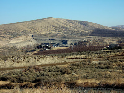
View of gravel pit that helped unravel the Badger Coulee/Yakima River story.
Goose Hill is rises up behind pit.


