Friday, July 29, 2016

Wenatchee Flash Floods

A look at the Wenatchee geology map shows that a fair bit of Wenatchee is underlain by alluvial fan deposits. I have not done any specific alluvial fan work in Wenatchee, but there is a history of flash floods coming out of the very steep drainages in Chelan County with terrible consequences (Flash flood in South Wenatchee kills 16 people on September 5, 1925). Pictures archived at the Washington State Historical Society show some of the devastation from Squilchuck Creek.


Squilchuck Creek has a larger drainage area than some of the other streams that enter Wenatchee from the steep mountain front to the west and is incised into the alluvial fan surface such that flash floods are delivered further down stream. Number one Canyon and Number Two Canyon end on alluvial fans with residential development.

Topography with well over 2,000 feet of vertical relief (USGS)

Aerial view of of drainages (USGS)

Lower end of Number 1 Canyon with hard to discern stream channel (image USGS)

Upper alluvial fan area on Number 1 Canyon (image USGS)

Sediment collection swale recently completed (Google earth)

The sediment collection system was tested this past winter by heavy rapid snow melt and very wet weather. There was some mud and water flows reported, but the collection swale reduced the sediment load fro the event.

FEMA flood maps show the projected flood elevations and velocities for the lower canyons and upper alluvial fans.  

The depth of projected flooding on the maps is not very high. However, the velocities are not safe for walking through and it should be assumed that there will be a lot of sediment and potentially debris involved in any flash flood event. The big risk is from stationary thunderstorms that would cause a very rapid flash flood with debris. A greater awareness of that risk developed over the past few years because of flash floods elsewhere on the east slopes of the Cascades.

I am not up on just what the projected recurrence interval would be or the consequences specific to Number 1 and Number 2 Canyons. The recent work on Canyon Number 1 (Number 1 Canyon Project) and some at Canyon Number 2 indicates that Chelan County and Wenatchee are aware of the risk. The County has a relatively new county-wide flood district and a few reports note that there has been an increase in intense summer storms and associated flash flooding in both Chelan and Douglas Counties.   

Thursday, July 28, 2016

Orchard Arsenic and Lead Legacy

Spraying dry lead on apple trees
(Washington State Historical Society, A.G. Simmer, 1925)

An effective means of controlling pests in orchards was to spray the trees with a mix of lead and/or arsenic. This practice continued into the 1950s. As lead and arsenic are elements, they do not go away. As such old orchards are often locations of residual contamination. Other pesticides may be present as well from past agricultural activities, but the long term use of lead and arsenic simply do not go away.

Conversion of agricultural land to residential or other uses has created a potential risk to human health due to the residual soil contamination. Washington State Department of Ecology has been attempting to address this issue and has conducted numerous soil cleanups where schools have been located on former orchards with elevated lead and arsenic levels in the soil (Former Orchard Lands). Thus far 26 school sites have undergone cleanups. The cleanups often simply cover the soils so there is no direct contact with the arsenic and lead. This is an effective approach but does require periodic inspection and an awareness by the property owners (school districts).

While the school sites have been treated, neighborhoods within former orchard areas face the same problem. An educational program has been the approach used by Ecology and local health departments. Some newer residential areas have gone through cleanups since the hazard has been recognized, but it is a significant planning issue for local governments in cities and counties where urban growth has been expanding into former commercial orchards in eastern Washington.          

Wednesday, July 27, 2016

Trail Blazers in the Field

Palmer Lake

In planning my schemes to explore the steep slopes above Palmer Lake, I anticipated having to navigate through some cliffy areas with forest as well as some undesirable vegetation patches. Instead of locking in on a specific route I started up the slope in the hopes that previous trail blazers would have created paths for me once I got near some of the tight spots.

I was not disappointed. After a steep scramble I found a well worn path cutting across the slope.


Some of the paths even had some nap sites.


These paths were blazed by a combination of herbivores. I suspect one set was developed by cattle. Another set was developed by deer. I flushed a few of them from their day time naps sites. The deer tracts and cattle tracts or combinations of both were pretty good at getting me through some cliffy areas; however, they tend to fade and spread into hard to trace routes when the slope opened up. The bighorn sheep tracts were useful, but they faded on rocky areas and some of the tracts tested my comfort with exposure.

But all together I appreciated all the trail blazing that got me past some cliff areas that I would otherwise may have been flummoxed by.   

Monday, July 25, 2016

Hydrology of Palmer Lake

A bit south of Smilkameen - Chopaka Wildlife Area is Palmer Lake.
 
Palmer Lake viewed from the southeast
Smilkameen River valley with Hurley Mountain on left
The relief from Smilkameen valley to mountain summit is 6,500 feet
 
The lake is within a deep valley that was at least in part modified by continental glaciation. The valley was carved at least in part by glacial ice that extended well south of the lake. As the glacial ice retreated during the late stages of the last glacial period the lower end of the present Smilkameen was blocked by the Okanogan ice lobe and water flow was diverted southward though the deep valley to other outlet locations - such as the valley east of Loomis.
 
 
Palmer Lake formed within the former glacial valley and the old ice age river route and this valley likely had a large glacier within it as well before the water flowed through it. There are glacial moraines as well as glacial lake sediments on the valley sides.

As a result Palmer Lake has some odd hydrology. The Smilkameen River flows south from BC into the valley and then makes a U turn before reaching Palmer Lake and flows east through a narrower canyon to the Okanogan River. However, during high water in the late Spring flood water flows south into Palmer Lake raising the lake level somewhere on the order of 10 feet.

 
As a result Palmer Lake has two deltas. One from the north associated with an overflow channel from the Smilkameen River and another from the south associated with the Sinlahekin River. The lake also receives groundwater from the high mountains on either side of the valley.

Friday, July 22, 2016

Smilkameen - Chopaka

A bit of lack connectivity of late. 
 
Made a side trip to the Smilkameen - Chapaka Wildlife Unit. The wildlife unit was purchased by the Washington State Department of Fish and Wildlife in 2012. The purchase involved several parcels and was at least partially funded by the Bonneville Power Administration as mitigation for dams on the Columbia River https://www.bpa.gov/Similkameen.pdf.  
 
Oxbow lake in Smilkameen River valley at Smilkameen - Chopaka Wildlife Area 

The Smilkameen River flows into north central Washington State from Canada east of the North Cascades. The river has a short stint in Washington before joining the Okanogan River at Oroville.

The geologic history of this river is complex. The river follows a deep valley though the mountains and likely was part of a larger river system that was altered by continental ice, and parts of the valley likely received diversions of water during the last glacial period. The last glacial period covered much of the North Cascades and mountains to the north in continental ice and the river systems were a bit rearranged as advancing ice blocked rivers and sent water down different drainages.

Perhaps the most spectacular feature of the valley is the steep and very high rise of Chopaka Mountain. The summit of the mountain is 6,500 feet above the valley floor over a horizontal distance of 2.5 miles. This sharp rise is approaching but a bit short but comparable to the Grand Tietons.
Chopaka Mountain
 

Chopaka Mountain

The east side of the valley

The road up the valley dead ends at a tract of Confederated Colville Tribal land. The Canadian border is a bit beyond. The local border patrol stopped by to make sure we were not up to some nefarious activity.  

Tuesday, July 12, 2016

Bolton Poison Oak and Black Berry

I hade a good geology venture to a favorite hard to get to shoreline bluff. More on the geology for a later post. 
 
Southwest tip of the Bolton Peninsula with Twin Rivers Formation exposure
 
One of the challenges on the Bolton and northern reaches of Hood Canal is to be alert for poison Oak.
 

The poison oak does well on the sunny south facing slopes. I find that it grows on the fringe of snowberry patches. The above small plant is within hard silts right at the top of the beach.

The other more constant bane of field navigation are black berry patches. But the start of the berry season has started, so I at least got a few nice snacks.

Monday, July 11, 2016

Low Tide at Dabob

I had some slope work out at Dabob Bay on the north end of Hood Canal. Dabob is well known to oyster fans. The broad tide flats on the upper bay, warm summer temperatures (see below) and clean water provide ideal oyster growing conditions.  
 
Average Maximum Temperatures                                         
                                     June   July   August  Sept.
Seattle                              69      72       73         67
Port Townsend             66      70       71         67
Bellingham                     66      71       72         68
Quilcene                          72      77      79         73
 
I was there during an exception low tide and had some company on the beach.

The folks above were a group of biologists doing a survey of the tidal flat life.
The tide was out far enough to expose the eel grass.


Any plenty of oysters growing on various substrates. These were on glacier erratic boulders.

And not all the holes in the sand. Lots of life within the sand on the tidal.

Friday, July 8, 2016

DGER Gearing Up For LiDAR

The Washington State Department of Natural Resources Division of Geology and Earth Resources has been gearing up for an expansive LiDAR program (DGER LiDAR Presentation). This gearing up is related to new funding as a result of legislative and public awareness that LiDAR can be a powerful tool for geologic hazards. LiDAR has a lot of other powerful applications and with time and better quality LiDAR the imagery and data use will increase. Perhaps the largest challenge is simply data management and ability to provide that data. 

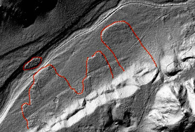
In the presentation linked above, the DGER had a LiDAR image of a set of landslides in the Cedar River valley southwest of North Bend, Washington. Below are images I gathered for the Cedar River valley in the same area.

Aerial view of Cedar River (USGS)

LiDAR based DEM from King County

Same image with mark up of landslide deposits

Another section of the valley (LiDAR from King County)

Mark up of slide deposits over glacial age river deposits (LiDAR from King County)

This reach of the Cedar River valley was blocked for a time during the ice age by the Puget ice lobe and then the whole valley was over ridden by the ice. As the Puget ice lobe retreated water flowing out of the Cascades and around the margins of the ice flowed through the valley with later rivers including the modern Cedar River down cutting into the valley fill sediments left by glacial ice, sediments from glacial margin lakes and glacial margin river deposits.

With the right programs, one can use the LiDAR data to emphasize and better visualize the LiDAR based imagery. Below is an an example from the DGER presentation of the same LiDAR images I present above. The DGER images are way better! The two images below are of the same location, but are flipped with the first having north at the top like the images above and the second with north on the bottom. I flipped them because my mind inverts the north oriented image the wrong way.


Below is the North Bend geology map (Dragovitch and others, 2009) that includes the same area.
 

Landslide deposits and scraps are indicated on the map. If one were producing a map of just large landslide deposits, the map may be a bit different and even the existing map might be tweaked a bit in interpretation based on the high quality LiDAR. For example several of the landslides clearly extended across the river. The detail of the slide deposits is very informative as to how these slides behaved.   

Thursday, July 7, 2016

Marblemount Nostalgia

I had a field site to visit near Marblemount. Marblemount is a small unincorporated town well up the Skagit River valley and is located where the Cascade River flows into the Skagit. The North Cascades Park headquartes is located in the town. The town itself is not up in the mountains, but is in the mountains. That is the Skagit valley at this location is only 324 above sea level. The valley penetrates deep into the range with high peaks and valley sides above the river bottom.

I do have a bit of nostalgia for Marblemount as it was the last bit of civilization or the first bit of civilization before or after field adventures for a couple of summers and early fall field seasons up the Cascade River valley. Alas my two former haunts are no longer doing so well.

The former Good Food

The local bar

Good Food was always the spot we stopped at after being in the field for a week to 10 days. It was a seasonal restaurant that faded after my time up there. The bar was in rather rough shape and had rather infrequent opening hours even when I stopped in after quick day trips to the less remote work sites. It was a fun place though with locals mixing with the curious group of out of area geologists wondering what it was like living in Marblemount.

The town site is not doing so bad as these old haunts would indicate. A gas station and convenience store has gone in, another restaurant has been built that routinely has barbecue and motel cabins down the road appear to still be doing just fine.


Wednesday, July 6, 2016

3D Laser Scanning - Underground Mine Mapping

LiDAR (light detecting and ranging) has been a great tool for visualizing earth surfaces. Dave Montgomery, a geomorphologist at the University of Washington has described LiDAR as "like having a new pair of glasses". You do not have to be a geologist to recognize large landslide complexes or even fault line ruptures on the earth surface.

But LiDAR techniques are more widespread than bare earth images. Ground based mobile LiDAR units are being used to map out 3D images for urban planning. This type of LiDAR 3D imagery is being applied to underground mines. 


Large underground mines can be a bit intimidating in a large part because it is easy to get disoriented. Most of my time in underground mines were one or two day ventures with guidance provided by the mine geologist or engineer.  With the LiDAR mapping of the mine and computer generated 3D image, one could carry a 3D map of the mine on a small tablet. A big change from the past.

Monday, July 4, 2016

Creative Math Reading

Posting has been a bit limited due to a combination of things. Some is work related. For example, as much as I would like, the following explanation as to Why I ought not to be concerned with Vf  is really not a good blog subject.
 

I am always impressed with the creative skills that some folks have that uses the language of math to describe things with a precision that English can not do. In this case a timely paper (for me) by Bouchet and others (2016). It takes a bit of extended concentration to work through what I am after on this matter as well as an openness as to not getting to the answer or clarity I would like. However, this particular explanation (one of several) was of some help.