Friday, February 8, 2013

Landslide Complex on Toandos: Brief Recent History

The winters of 1996 - 1997 and 1997-1998 had a few weather events that triggered lots of landslides in western Washington. Many of these slides were shallow surficial slides particularly in early 1997. At several locations on the Toandos Peninsula on the west side of the northern side of Hood Canal very large, deep-seated landslides took place in early 1998. I have done a number projects at these big slide sites or walked by them on the way to other sites and recently had the opportunity to revisit one of the big slide sites.

I pulled up a series of aerial photographs from 1994 before the slide, from 2000 a couple of years after the slide and 2011 more than a decade after the slide. The red dot in the images (click image to get a larger image) marks the upper top edge of a landslide scarp I identified back in 1998.


1994

In 1994 most of the bluff slope is tree covered. The beach is located on the lower right portion of the image. But the 2000 aerial shows a much different picture.


2000

In the 2000 image the upper scarp is clearly visible. The land surface on the south side of the scarp had dropped approximately 15 to 20 feet. The entire tree-covered area between the red dot making the upper scarp and the treeless slope above the shoreline was broken up into a series of scarps and crevice-like features not at all unlike a glacier. The lower end of this slide calved off over an approximately 80-foot high bluff. I witnessed some these calving off events while visiting a nearby site - Unfortunately pre digital camera with video.


2011

By 2011 the readily apparent fractures seen in the 2000 aerial had disappeared as trees grew and the forest canopy blocked the aerial view. This is one of the challenges of aerial images in assessing landslide histories. Back in 1999 LiDAR was not available for the area. But the LiDAR image clearly shows the hummocky nature of the slope between the headwall scarps and the top of the shoreline bluff. The shoreline bluff is defined as the dark band angling across the lower left portion of the image.


LiDAR

This section of bluff slope above Hood Canal is a long stretch of deep slides with a headwall scarp that takes some really big bites out of the upland.


LiDAR of larger area
 
The red dot indicates the specific site I visited, but the big bites into the upland to the northeast give a sense of how big these failures can be. This slide is a bit complex with several things driving the failures: erosion at the shoreline, well drained compact sand and gravels overlying a nearly impermeable silt/clay, and an inherent structural weakness within the underlying silt/clay unit. The later failure mechanism is within preglacial silts and clays and at one location up the coast to the north there are some massive slide areas with headwall scarps as much as 1,500 feet inland from the shoreline.
 
This particular slide area got the attention of Jefferson County officials back in the early 1980s pre Critical Areas Ordinance days. The area was assigned a moratorium for building unless a geologist/engineer provided a report. A few reports have been completed with setback recommendations as reported with parcel tags ranging from 30 feet to 268 feet. 
 
I have looked at this slide on several occasions. Thus far I have written only one report on this particular slide complex and that report was a bit to the northeast and I was more conservative with my setback distance recommendation than the numbers I found on the County web page and I even added a further caveat that I do not typically use regarding reassessment of the site post new scarp or upland fracture development.

Periodic very wet periods will cause these slopes to fail on going erosion. But then throw a quake with a good jolt to these slopes and use your imagination or quantitative (with assumed or measured values) slope models.

Thursday, February 7, 2013

Policy Shaped by Weather Events

Tim Johnson recalled the 30-year anniversary of a multiple landslide event in Whatcom County, Washington cascadiaweekly.com/recalling_the_30th_anniversary_of_the_smith_creek_landslide. The article includes some quotes from a certain geologist. The context of the anniversary has much to do with a policy issue that is and has been much discussed and considered that I have posted a few times and summarize in a longish manner HERE (lake-whatcom-reconveyance).

Tim points out how the storm and related landslides associated with forest practices brought about a policy shift regarding Lake Whatcom management, forest ownership in the watershed, forest practices in the watershed and in more recent years the move towards local control over 8,000 acres in the watershed.

But the 1983 event brought about other significant changes as well. The general view of forest industry practices took a stronger shift towards better regulation. The urgency of those changes increased somewhat due in a large part to practices that damage endangered salmon species habitat. The 1983 events were a clear demonstration of how forest roads posed a threat to neighboring properties sometimes miles from where the road was built such as at Smith Creek. Poorly constructed forest roads have also impacted shared natural resources and stream habitats. The 1983 storm event event at the Lake Whatcom watershed and elsewhere in northwest Washington not only caused damage during the event, but harmed streams and the lake itself for perhaps a decade or more as the excess sediment and debris introduced to the streams was processed and transported in subsequent years. Some of the policy issues regarding forest practices and forest road issues are still playing out as we learn more about the best approaches and how to consider risk in a reasonable way.

Thinking about how a single storm in 1983 can have lasting policy implications caused me to consider other storm events that have shifted policy.

November 1990

In early November, a large flood event on the Nooksack River caused a rethinking of flooding in Whatcom County. In addition to the 1990 flood, a large damaging flood had taken place just the year before after early fall snow followed by rain.


These two floods led to the county creating a County-wide flood tax district for generating funds for reducing flood risks. The City of Everson which had been hit hard by both floods pushed forward with an ambitious levy project that thus far has not allowed a flood into the main part of the city since. That approach along with the widening of the state highway bridge at Everson has reduced the flood risk frequency in Everson, but increased the downstream frequency. Several other major levy projects with lasting consequences moved forward at other locations on the river as well as on some tributary streams - not all were very well thought through and were at least in part the result of having lots of money without a comprehensive flood plan, a problem that has at least been partially resolved (warrants a few posts).

Winters of 1996-1997 and 1997-1998

The winter of 1996-1997 was very wet. But added to the generally very wet conditions was a huge snow storm over western Washington on New Years Eve. In some areas of western Washington there was already a lot of snow on the ground. It was the one year I thought it a good idea to go up and shovel snow off the roof (a drift from blowing snow off our neighbors roof had reached nearly 4 feet deep on our back roof). The cars on our street in Bellingham had become mounds without a single bit of steel visible on the entire street. And that was snow condition before the New Years Eve Blizzard arrived. Another foot of snow fell that night and early morning and the snow extended deep down to the south throughout the Salish Sea lowlands. The temperature crept up afterwards to a bit above freezing and then it began to rain. A lot of rain and a rapid increase in temperature.

Roofs collapsed - particularly car ports at apartment buildings and covered marinas. But for geologists the big story was steep shoreline bluffs failed at a remarkable rate. Not just steep slopes but steep slopes with homes. Or worse, steep slopes with homes below. Homes that had been permitted by various local governments. Slope stability became real. It was not some abstract thing that might happen. A writer for the Atlantic Magazine pointed out the disparity of funding for landslide research and development regulations compared to earthquakes even though landslides were equally bad at killing people. This was in part due to her living on Bainbridge Island where a family was buried and killed in their home.

The winter of 1997-1998 did not have the single dramatic landslide inducing storm of the previous winter, but it was very very wet and was likely additive to the wetness of the previous year. During that winter, there were not nearly as many landslides, but numerous, very large, deep-seated landslides reactivated including ones at sites with homes. A slide in Kelso and another near Olympia impacted dozens of homes.

The cumulative results of hundreds of landslides, property damage and deaths reached the policy action level. Subsequently fairly robust geologic hazard codes regarding landslides were implemented by local governments via local Critical Areas Ordinances as required by the State Growth Management Act. Most communities treated these hazards in an appropriately cautious manner. I will add, that Whatcom County also did a good job on recognizing alluvial fan hazards due to the 1983 event, whereas other communities have not recognized this risk nearly as well.

The other big change was that the State Legislature passed a law requiring geology licensing for the practice of geology. Geologic determinations can only be made by a geologist. There is still some lingering code issues on this matter in a very few communities that likely will take time to resolve, but most counties and cities have done a good job with landslide hazards.

Weather Events From Far Away

Climate events elsewhere may also have a big impact on policy in Washington State. To a degree Hurricane Katrina and I suspect Sandy as well as others that are easy to forget living so far away will, if they have not already, play a role in flood policy. New rules for levy construction and maintenance are being implemented with no small amount of controversy in Washington State. Federal Flood Insurance is hitting financial walls due to communities elsewhere (including some in Washington State) being very permissive about flood plain development. The ripple of far away events shape how the US Army Corp and FEMA approach flood issues.

Wednesday, February 6, 2013

Coal in Whatcom County: Glen Echo Mine

Updated on 12/4/14

In reviewing some historic aerials, I came across this aerial noting the Glen Echo Coal Mine. The markings were on a 1960s era photograph.
GOOGLE AERIAL VIEW


1960s era aerial photograph showing the Glen Echo Mine on Anderson Creek is in western Whatcom County

Close up view of the old washing plant
 buildings near mine site reported by GM to have been used as a rendering plant
 
Looking Back by Dorothy Koert and Galen Biery provides an interview of the former owner, Joe Jussel, in their chapter the coal mining era in Whactom County. According to Jussel the coal seam was discovered in 1896 and opened in 1918. Jussel acquired the mine in 1942. Jussel ran the mine for only a few years before closing it. The mine closure was more related to a shift in energy economics in the Pacific Northwest as natural gas became available along with very cheap electricity.
 
The coal seams in Whatcom County are within the the extensive Chuckanut Formation a predominantly sandstone formation of Eocene age. The narrow underground seams could not compete with the cheap energy sources or with the large thick seamed surface mines elsewhere in the west. By 1954 coal mining came to an end in Whatcom County.
 
Coal has been very much in the news in Whatcom County with the proposed scheme to build the largest coal export facility on the west coast. If built, the export facility will ship coal from Montana and Wyoming. 
 
Given the relatively thin local coal seams and the low value of coal, it is not likely that having a nearby export facility will respur coal mining in Whatcom County anytime soon. However, there has been some exploration interest in possible coal bed methane with exploartion wells drilled in the north part Whatcom County in the past decade. Perhaps the next big hot topic.

Tuesday, February 5, 2013

Glacial Drift Slab Failures in Port Townsend

A cliff of vertical glacial drift rises above the Port Townsend, Washington waterfront. The drift was deposited directly by glacial ice. The approximately 2,000 to 3,000 feet of glacial ice that was piled on top of the drift has greatly compacted the drift such that it is very hard and stands like a wall of concrete. However, some moisture seeps in, and after a bit of freeze and thaw weather occasionally a slab will peel off the face. On my last trip through PT, several slabs had calved off the cliff face. This gave me a chance to assess the size and mechanics of the recent failures - not an idle issue for me as I encounter slopes like this doing geology hazard assessments. 

Small slab failure


This failures was a bit bigger and appears to have initiated further up the slope and over topped the road side barrier


Recent slab failure next to a slope that has recessed back a bit more and has a lower vertical cliff


Closer view of the slab failure, note the few boulders embedded in the drift


View looking north along Water Street or Washington State Highway 20

Sunday, February 3, 2013

Yakima Company Turns Recess Appointments Upside Down

Noel Canning, a long time canning and bottling company in Yakima recently won a court case in the US Court of Appeals HERE that has major constitutional and governance implications /wonkblog/wp/2013/01/25/court-decision-on-recess-appointments-could-make-america-harder-to-govern/.

The National Labor Relations Board (NLRB) had ruled against Noel Canning regarding a disagreement with the Teamsters Local 760 by adopting an Administrative Law Judge decision in the case against Noel Canning. Noel Canning appealed the NLRB ruling to the US Court of Appeals for the District of Columbia Circuit.

The Court ruled on two matters: first was whether Noel Canning had violated labor laws. In that the Court agreed Noel Canning did in fact violate the two labor laws in question. Hence, there was no statutory relief and that opened the door for a Constitutional decision by the court.

The Court ruled that Congress was in session when the President made the recess appointments of NLRB members and therefore the appointments were not valid. The President made the appointments even though Congress was essentially out of town and only holding pro forma meetings to claim they were in session and not in recess. This approach would never fly with the school attendance office, but it was good enough for Congress and the Court of Appeals.

Without the appointments to the NLRB, the NLRB can not make any rulings at all because the NLRB currently does not have enough members. Hence, any rulings over the past year may be at risk and no additional rulings may take place. All because the US Senate has blocked appointments, not by voting "no", but by simply allowing rules that block a vote from ever taking place.

The situation is we have laws on the books (in this particular case on the books for decades) that were clearly violated, but no enforcement can be done due to procedural maneuvers by sometimes individual Senators blocking any appointments. Yes, I know they are Republicans doing the blocking. 

Saturday, February 2, 2013

Metamorphosed Turbidites on Lopez Island

The same bedrock outcrop on Lopez Island that was glacially striated described HERE had other linear features: bedding and penetrative cleavage. It would be a betrayal of my metamorphic tribe not talk about this bedrock.

Protolith sedimentary bedding with a penetrative cleavage cutting across the bedding at an angle

The protolith is what the rock was before it was metamorphosed. In this particular case the rock was a sandstone (lighter color) and a silt or mud stone (dark color).

These rocks were once buried very deeply, but oddly were not very heated. During the deep burial minerals in the sandstone and mud stone were squeezed and their atomic bonds were reshaped and realigned into new minerals - unfortunately not at a scale that can be seen at the outcrop scale but visible at the microscopic level. The microscopic metamorphic minerals include lawsonite, pumpellyite and aragonite. A mineral assemblage that indicates very high pressure (deep burial) but relatively low temperatures. Not a common assemblage as deep burial typically means hot as well. Some how these rocks were deeply buried yet not very heated up. This suggests that this ocean floor formation was thrust into a deep ocean trench and before they got heated up were rethrust up out of the deep burial.

Although the mineral assemblage can not be seen at the outcrop scale, the up side is the original sedimentary bedding within the rock can readily be seen. And the metamorphic cleavage can be seen crossing the bedding at an angle. The orientation of this particular outcrop is excellent for measuring both the bedding and cleavage orientation.


Bedding orientation in red, cleavage in blue


The above section of the outcrop provides a nice view of the bedding with fractured steps in the rock associated with the cleavage. The sedimentary beds are consistent with the unit being a distal turbidite with alternating silt stone and sandstone. Tubidites are a common ocean floor depositional feature from under water landslides traveling long distances from the failed slope via turbidity currents.


More cross cutting cleavage
 
This particular formation has been metamorphosed more than once. A lower pressure over print with some brittle deformation that created discrete openings filled with dissolution fluids forms another metamorphic fabrics in the formation.
 

Pressure dissolution
 
This formation has several stories to tell. By no means are these stories easy to read. The San Juan Islands have the best outcrop exposures in western Washington, but the rocks exposed are enormously complex and the exact story of how the above turbidite sequence formed, was metamorphosed at high pressure and low temperature, and then ended up here has been a difficult challenge for geologists that have taken on the challenge of deciphering these rocks. Over the years some wildly divergent interpretations have been proposed. I only know enough to get confused and hurt my head over all I can't remember.
 
This outcrop was distraction from the work I was supposed to be doing that involved a much younger units.
  

Glacial drift and shoreline processes at eroding bluff

Friday, February 1, 2013

Glacial Striations on Lopez

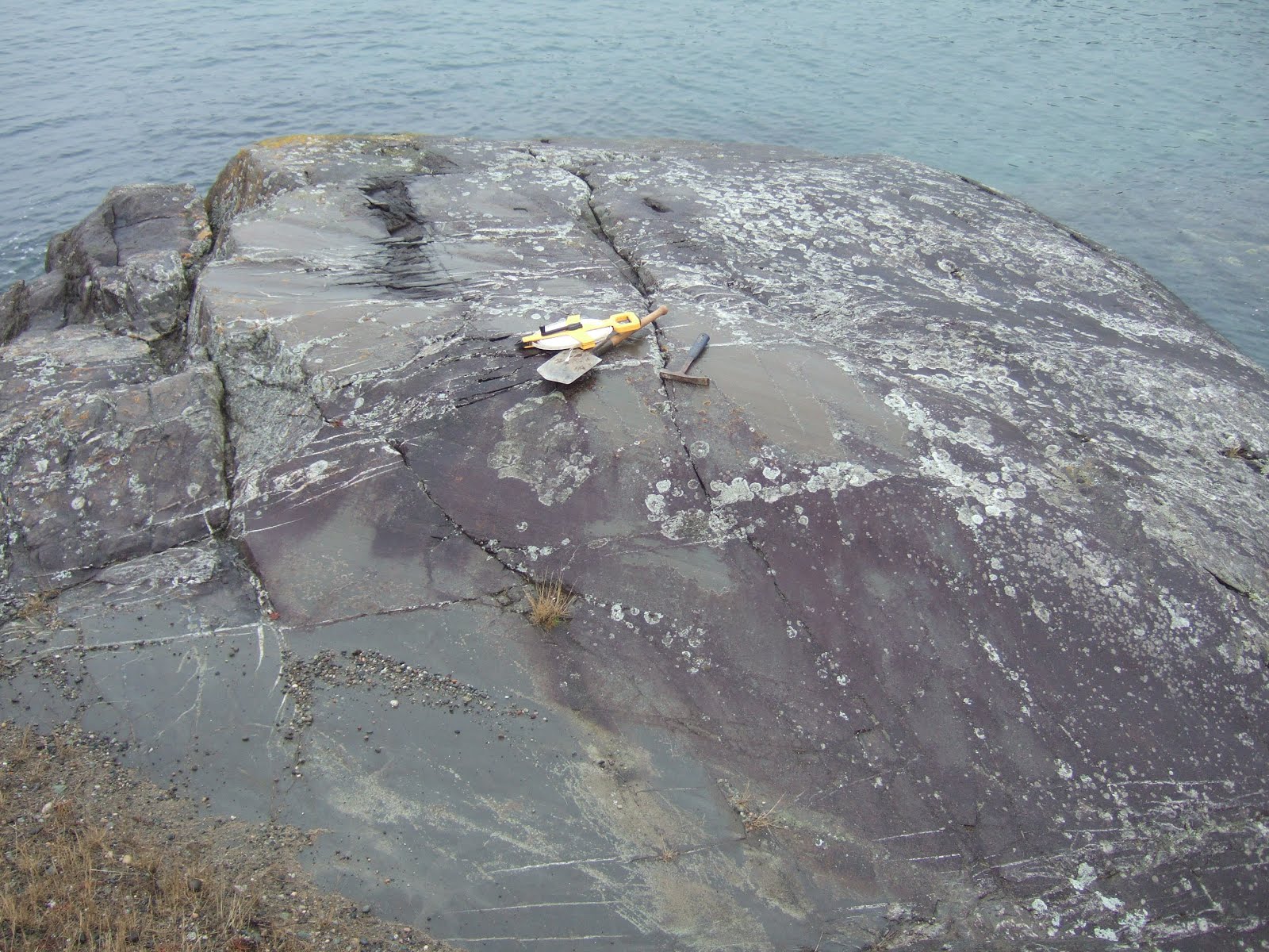
I always enjoy seeing glacial striations. The San Juan Islands have lots of hard glacially striated bedrock. This particular bedrock exposure on the south end of Lopez Island provided some distraction from the specific issue of my site visit.

Striated bedrock and a some of my field gear.
Striations run from right (north) to left (south)


Fine striations scratched into the metamorphosed sandstone


Take 2,000 or 3,000 feet of ice pressing down on the glacial erratic in the picture and it is easy to visualize the bedrock being scratched, but all the small rocks within the overlying drift would have made an effective "sand paper".


Broad swale like erosion into bedrock

At this location near the southwest corner of Lopez Island the striations were oriented almost exactly north-south. The striations provide a data point regarding ice movement over the area.