Friday, December 2, 2011

Driftless

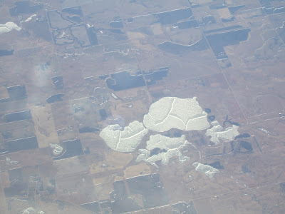
On my return from points east I got a nice, if not a bit of a fuzzy, view of the Driftless Area of northeast Iowa as well as adjoining states. The area was not glaciated during the last few glacial periods. The continental ice sheets instead wrapped around the area. It was, at least for a time, an island in a sea of ice along the southern margin of the ice sheets. The term driftless refers to the lack of glacial drift desposits in the area.

As such the area has not been rubbed smooth by glacial ice like other areas on all sides of the driftless area. And the soils, topography and ecology of the area is markedly different than glaciated areas that surround the driftless area. Note in the photograph the generally incised stream valleys that this older surface of land has compared to the smooth plains that begin at the bottom of the photograph.

Driftless Area, northeast Iowa

Image from University of Minnesota Extension

I enjoyed the view of this area as Will and I drove across this area in August. While driving across northern Iowa, Will took a long 1.5 hour nap and when he woke joked that I was driving in circles as we were still driving through miles of gentle plains with corn and soy. The scenery changed abruptly upon entering the driftless area. Compared to the plains that surround this area the area is rugged with steep hills. And after days on the plains very scenic. 

Another aspect of the view I enjoyed was just the week before I had written up a couple of sections on a paper I am working on that included a description of a driftless areas in southwest Washington State. The same deeply incised stream channel network and different soils. An ancient landscape compared to the glaciated and Missoula flood landscapes that cover much but not all of Washington State.

Wednesday, November 30, 2011

Andesite from Washington State in Chicago

Even if your not that interested in architecture and urban design, you will become so when in Chicago. Lots of great buildings and public spaces. And some geology in some of those buildings HERE or for a great resource on stone and buildings check out David Williams' stories-in-stone.

One of my favorite buildings in Chicago is the Tribune Building with its flying buttresses on the upper floor and Gothic touches.

Tribune Building left of center with flying buttresses

Entrance to the Tribune Building

I noticed a feature on the walls of the Tribune Building I had not noticed before. On the walk up to the entrance pictured above note the protruding objects embedded in the walls. These objects also had caught the attention of some French visitors as well as my own attention. The protrusions were rocks, stones and bricks taken from other buildings or places and cemented into and onto the walls of the Tribune Building.

Stones and building materials embedded within walls of the Tribune Building 

Of course this led to a quest to find if there was a stone from Washington State. And sure enough there was a chunk of andesite from Washington State.

A piece of Washington in the Tribune Building

The Yellowstone hotspot was well represented with lava from Oregon, Idaho and Wyoming all possibly from the path of the hotspot over time:

Basalt from near the mouth of the Columbia River - I am not sure this is hot spot lava as it may be a more recent ocean floor basalt accreted to the North American margin.

Craters of the Moon basalt is very likely from the hotspot path

This piece of Wyoming looked is obsidian

One more rock in the walls of the building (there are 120 stones from around the world) is from Germany.

Basalt from Remagen Bridge across the Rhine River

A small group of Allied forces got a view of the Remagen Bridge in March 1944 and were surprised to see that it was still standing as the Germany forces had pulled back across the natural defense of the river and blown most of the bridges. An immediate change of invasion plans took place and Allied forces were immediately diverted to the Remagen Bridge before the Germans could destroy the bridge. My father was among those diverted and Remagen is where he began a full month on the front lines pushing into Germany. The bridge span did collapse from German shelling a few days after my father made the crossing, but the basalt support towers of the bridge are still standing.  

Tuesday, November 29, 2011

Some Water Views

I headed east for a combination of Turkey Day and other activities so posting opportunities have been limited as it should be. Departure from Seattle provided a great view of the third runway storm water pond for treating storm water run off from all that pavement.


Next we had a great view of a sediment plume in the South Sound between Seattle and Tacoma. Heavy rain fall had generated a plug of sediment discharged into the sound.

The source of a at least part of the sediment was evident in the muddy waters of Commencement Bay in Tacoma from the Puyallup River.

Then the ground was obscured with clouds but with a brief break to see Lake Tapps, a glacial carved depression on the uplands east of Tacoma.

Then a long stretch of clouds with only very fuzzy views of eastern Washington before seeing a nice meandering river somewhere in Montana. Not entirely sure where this was as it was a brief view of the ground before more clouds.


Things cleared up over North Dakota which was fun as I had been in North Dakota for a spell this summer and recognized many features. I liked the image below because it shows that North Dakota is a watery state. Lots of ice age kettles and depressions filled with water.


Tuesday, November 22, 2011

High River Levels Bring More Than Flood Risk

With heavy rains there is the risk of river flooding. But the another risk is channel migration. That is the risk that the channel of a river will shift. I recently assessed a reach of a northwest river for channel migration risk. Pretty simple evidence was visible to show that the river has been recently migrating.

Concrete foundation stem wall and concrete post supports

Undermined structure

undermined trees

Another home foundation

Utilities leading to where homes sites are now occupied by the river

It was not the first time I had assessed this particular river. Other reaches of this river have migrated much more dramatically over the past 50 years. At one reach upstream of the pictures above the river did a complete course shift in one storm event moving to a new channel nearly one mile away from the previous channel. The particular reach I was investigating was on a reach I first looked at ten years ago. I was on the opposite side of the river on that project and it was very clear the river was starting to migrate away from the property - good news for one side of the river is not so good for the other side.

The risk of flooding along this particular reach of river is low. The 100-year flood inundation area does not extend over much of the valley. But the risk of channel migration, a much more catastrophic problem, is obviously much greater.

Sunday, November 20, 2011

Doc Hastings and San Juan Island National Conservation Area Proposal

I have previously posted about a proposed San Juan Island National Conservation Area
national-conservation-area-and-san-juan
sam-crawford-proposes-supporting
whatcom-county-council-supports-san

Seems National Conservation Areas are among the things Doc Hastings Chair of the United States Congressal House Committee on Natural Resources does not care for.

Per McClatchy reporter Rob Hotakeinen:

"When Salazar suggested listing the San Juans and sites in eight other states as new wilderness and conservation areas, Hastings was quick to object.
He said Congress "has the sole authority" to decide which lands should be designated as wilderness "and which should instead be allowed to contribute to the full range of recreational, conservation, economic and resource benefits that carefully managed multiple-use lands provide."
Besides, Hastings said, the country can't afford any more public land."

Designation of Natural Conservation Areas as proposed does require an act of Congress as does the designation of wilderness areas. I know that Ken Salazar (Interior Secretary) is well aware of this. I am not sure what Mr. Hastings meant by "the country can't afford any more public land" as the lands in question are already owned by the public. In fact, part of the motivation for the San Juan designation is to better and more efficiently manage these lands.

The context of Hastings comments was in regards to a hearing on energy prodction from public lands and waters. Wilderness or conservation areas often trigger quick objections on the broad principle of not wanting to lock up lands from resource extraction. Hastings is an advocate for opening up more land for oil and gas development. Hence, wilderness proposals and conservation areas may get a bit of  broad brush treatment that is not necessarily reflective of the underlying geology. Not much chance of energy production from the small scattered islands and rocks in the San Juan Islands of northwest Washington and other than quarry rock not much mining value either.

Besides the energy issue, Hastings' comments regarding public land raises an over century old argument about public ownership of lands. It also revolves around the long standing struggle between local desires to extract revenue from Federal land and Federal control of those lands. In this regard, National Conservation Areas should have some appeal as it involves local planning efforts.  

It is a bit ironic that the background picture for the House Committee on Natural Resources web page has a picture of a wilderness area in Washington State as its background image http://naturalresources.house.gov/ and Doc Hastings' on web page includes a rolling set of pictures that includes a view of a Hanford Reach National Monument and a National Scenic Area.

Perhaps those images tell a truer story about the values that tend to prevail over the rhetoric and political dogma, otherwise pictures of open pit coal mines and other resource extraction images should be included.

Saturday, November 19, 2011

Hanford Sand Dunes

Sand dunes at Hanford area viewed from across the Columbia River at Ringold

Dunes are the faint light area in the satellite image (USGS)

Having grown up in eastern Washington I found that while traveling or living any distance from eastern Washington I frequently had to explain that eastern Washington is dry. In fact, large swaths of eastern Washington is desert. Parts of the east side basin are so dry that it is marginal for even sage brush to survive. And there are several areas of sand dunes in this dry landscape.

Hanford sand dunes and Columbia River.
Irrigated land on the east side of the river is irrigated via the Columbia Basin Project 

The largest dune field in eastern Washington is on the U.S, Department of Energy Hanford Reserve. A fair bit of the dune area at Hanford has become stabilized with vegetation hinting that for a time the area was even drier. But the core area of the Hanford dunes still contains a large active dune field. Public entrance to the dune fields at Hanford is restricted since the Hanford area was established as a nuclear materials production site. I got a glimpse of the Hanford dunes from across the river on a recent landslide inspection adventure.

The sand for these dunes is derived from from sands deposited by Missoula Flood waters that swept across the Hanford area depositing gravel, sand and silts. The dry climate and prevailing southwest winds has formed the dune fields which are slowly being blown into the Columbia River. Perhaps some of the sand from these dunes blown into the Columbia is now part of the sand dunes along the beaches of the southwest Washington coast.