Thursday, September 30, 2010

My contribution to the columnar state of mind

Dave Tucker alerted me to a request for columnar jointing from Washington State from magmacumlaude.blogspot . Apparently a number of geos are posting about columnar jointing. As any magmatitist, tuff cookie knows, Washington State has lots of columnar jointing because we have have lots of thick lava flows. The Columbia Basalt Group is one of the largest lava fields in the world and we also have the Cresent Basalts on the Olympic Peninsula and some more basalts in southwest Washington. And of course we have the Cascade volcanoes.

David Tucker obliged with a series of his pics HERE. Other geo blogs with columnar posts are
geotripper.blogspot
geologyblues.blogspot
geologyblues.blogspot (Phillip did two)
outsidetheinterzone.blogspot
highway8a.blogspot
highway8a.blogspot (Silver Fox did two)
glacialtill.wordpress
and perhaps the best entequilaesverdad.blogspot

So my contributions to the cause:

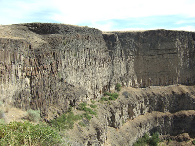
Cliffs of the Palouse River Canyon - Columbia River Basalt Group 

Devils Canyon
Wanapum basalt is on the left with younger basalt of the Saddle Mountain basalts filling in the ancient canyon and then topped by a third flow.
Twin Rocks, south of Wallula

Horse Heaven Hills at Wallula Gap

And from the tribal homeland: "I went to the huts of some of the savages that were there, who told me of the great misfortunes of our people who were drowned at that place and showed me many jewels and valuables of theirs, which distressed me greatly" - Fancisco Cuellar, describing the northern Ireland coast in 1589.


Wednesday, September 29, 2010

Esker Near Lake Padden?

Another UPDATE: See below
UPDATE: See below
I paid a visit to my local County Council last night regarding Lake Padden, a lovely gem of a lake in south Bellingham. Essentially every time anything comes up regarding that lake either the City Council or County Council gets to see me. Beforehand I was checking out the watershed boundaries using LIDAR imagery when besides the really cool folding apparent within the Chuckanut Formation, I spotted an interesting feature snaking across the slope to the northeast of Lake Padden. I have not ground truthed this feature, but it sure looks like it is an esker.
Possible esker near Lake Padden
The esker is the squiggly line across the otherwise smooth slope.
Clicking on the image will make it a lot easier to see.

Eskers are formed by water flowing underneath glacial ice, but instead of eroding downward into the ground surface, the water erodes upward into the ice. When the glacial ice melts away an inverted stream bed is left behind. LIDAR is pretty good at spotting eskers. They are otherwise hard to see in western Washington where the land is covered with trees.

Eskers are part of the National Natural Landmark designation on the Waterville Plateau in central Washington. The Waterville Plateau is west of the Grand Coulee. The continental glacial ice margin was located across this plateau and wonderful eratics and terminal moraine features as well as eskers cover the area north of Highway 2. The following Google earth Images are of a esker near Simms Corner.

Esker on the Waterville Plateau
Oblique view of esker showing inverted stream bed.

Update: Dave Tucker emailed that he knows of one geologist that did check out the possible esker. He thought it might be a morainal feature. I'll throw out another theory I have that the feature appears to be just below the crest of the slope from the north and may be a small depositional feature as the glacial ice rode over the crest of the slope from north to south. Anyway I look forward to hearing from some ground truth views of the feature. I do know that there is a morainal like feature to the southwest of the word Padden on the above map. As always thanks Dave for the info.
Another Update: Doug Clarke (personel communication, 2010) interprets the feture as morainal. Thanks Doug.
Two thoughts on this. One is the intent of this blog is to share observations so the input is greatly appreciated. And two, it is clear that LIDAR helps identify features that can be pursued in the field. Now I am thinking about what type of moraine and why is it there. But keep in mind that not all questions and features are readily answered or explained. Think Mima Mounds or just exactly what happened to the pronghorn antelopes in eastern Washington.
Sunday, September 26, 2010

Fog on the Horse Heaven Hills south of Benton City

Last week I posted a bit on having a sunset picnic on the hinge of the Horse Heaven anticline just south of Benton City. I have a different view of the same location from late last fall.

Fog on the crest of the Horse Heaven anticline south of Benton City

The fog bank covered the ridge line for well over 24 hours. Having lived within view of the Horse Heaven Hills, I know that this is not an unusual scene. During the winter air flow from the southwest out of the Columbia Rover Gorge rises up the south slope of Horse Heaven anticline and cools enough to begin condensing. Then as it descends the north slope of the anticline it warms and evaporates before reaching the valley floor.

McBee Road can be seen angling up the slope in the right portion of the picture. The lumpy area on the lower part of McBee Road is an old landslide deposit from the slope above. Lots of slides in this area are associated with the Missoula Flood; however, this particular slide came off a slope well above the flood elevation. The bedrock on the crest of the anticline is highly fractured and the slope is steep.

The topo map of the area shows how the crest of the anticline is hinged at this location and changes from a northeast trending fold to a southeast trending fold near where McBee Road crests the ridge line.


The slopes of the ridge at this location are predominantly bunch grass. The land in this area is managed by the Bureau of Land Management (BLM). Relative to Oregon, Idaho and other western states, Washington State does not have as many large tracts of BLM land. As evidence in the picture below the grass land is in good condition, but I do not know the details of the BLM management plan for this area. There currently is a weather tower on the summit ridge likely doing a wind study so windmills may be in the future on the ridge line of this BLM land.


Bunch grass on the slopes below McBee Road

We made the drive up the ridge last fall into the fog. The temperature in the valley was mild - upper 50s. The ridge line was just at freezing with just the beginning of ice rime formation. When I lived in this area, my mates and I ran these ridge lines in the winter and often ran through ice fog like that seen above. We would be completely covered with frost except our skin.
    

Saturday, September 25, 2010

What Are They Looking At? Another nice sail on the Steilacoom II and a Natural Bridge

 I took two pictures of these folks enjoying the back deck of the Steilacoom II to capture the rock of the boat. Note the difference in the horizon between the two pictures. The Port Townsend to Keystone run crosses the entrance to Admiralty Inlet between Puget Sound and the Strait of Juan de Fuca. As such there are occasions when there is a bit of ocean swell. The ride is not long enough to get sea sick on. At least I have never seen anyone get sick, but I was on the boat once when a wave broke through the car deck.

Anyway as last evening's crossing progressed the sunset got better and better and brought lots of folks out onto the deck.
Point Wilson at sunset with the Strait of Juan de Fuca to right


Most of yesterday's ventures were simple hazard assessments, but one site had an odd feature that is a first for me. A small slope failure leaving a natural bridge.


Thursday, September 23, 2010

Pile Driving Noise Changes

Last winter I had a small project making sure some piles were embedded deeply enough for a dock and landing at a small inlet off of Hood Canal on the east side of the Olympic Peninsula. (Hood Canal is named a canal but is a natural body of water formed during the last glacial period). I was not involved in the initial design or scoping of this project, but a clever engineer placed a note on the design drawings that the pile depth should be approved at the time of pile driving - passing responsibility to whoever took on the oversite.
One of the permit conditions was that the piles were to be driven using a vibratory pile driver.

Driving a steel pile with a vibratory driver using a crane on a barge

This permit condition is the result of studies on water noise impacts to fish and sea mammals. The more typical hammer pile driving can generate intense noise pulses in the water that are intense enough to tear fish bladders and destroy the hearing of fish (Laughlin WSDOT, 2005 and 2010). Lots of piles are driven into water for docks and bridges. Hence, this issue is posing a challenge for in water works - think ferry docks, bridges, and marinas. Washington State Department of Transportation has studies using bubble curtains around piles to dampen noise with some success, but as always "more study" is needed. Lots of physics, biology and acoustics; reading the studies is a good brain work out and certainly a regulatory challenge.


Studies on hammer driving which is basically dropping a big weight on top of the pile to drive the pile versus vibratory driving indicate that the sound intensity and pulses are substantially lower for vibratory pile driving. Hence, the condition my client had on pile driving. The vibratory pile driving basically shakes the pile through the sediment. I was surprised how well it worked, but we were unable to drive through the old log road that had been constructed along the shoreline without moving the pile locations slightly.
Steel piles prior to dock and landing reconstruction. The two sheds are 100+ year old structures from old fishing days. Grassy area at the base of the slope was an old road bed as tide lands were the first "highways". 

Tuesday, September 21, 2010

A little more on Shoalwater

As a follow up on yesterday's post on Cape Shoalwater I marked the location of the rock armored home that was pictured in yesterday's post on the 1990, 2005 and 2006 aerials/satellite images. The change from 2005 to 2006 is ---- use your own adjective.
House site 1990 is circled

2005 and the water view is fantastic

2006 and the ocean can be viewed from three sides.

I am not sure of the permitting rules in Pacific County, but it appears the home was built sometime after 1990 as I can't see it or an access drive to the site in the 1990 image. There are allowances for reasonable use of your land that varies from community to community. In a small coastal county like Pacific County living with the fact that much of the developed area will be inundated by tsunami waves when the next big subduction quake takes places, the attitude towards the impermanence of homes on sandy shores may not be the same as more stable areas. I have to say I was impressed with the effort by the property owner to save the house without moving it. Keep in mind this is the open Pacific Ocean and this coast gets really big waves. Dave Tucker noted via email that the home was posted with a sign saying Isle Knot Go. Another home was labeled Willy B Next.
One last note. As stated in yesterday's post most of the shoreline in this area is accreting with lines of dune sets paralleling the coast. As the new land and sand is added, the dunes are covered with forest. The low areas behind the dunes are wet land areas ideal for growing cranberries. The farm fields in the upper right of the satellite images are cranberry bogs.

Cranberry bog in winter near Cape Shoalwater


Monday, September 20, 2010

Cape Shoalwater or Washaway Beach

Cape Shoalwater is located at the north entrance of Willapa Bay on the southwest coast of Washington. This is a site of very rapid coastal erosion. I found by comparing satellite images from 1990 to 2009 the rate of erosion is impressive. Since the late 1800s the erosion has moved inland over 2 miles. Prior to 1990, thirty homes have been destroyed or moved, a light house, school, cannery and grange halls have been lost and the state highway and a cemetery were moved. In 1995 the State Department of Transportation spent 27 million dollars building a heavy groin and jetty to protect the new highway. 
Red line marks the 1990 coastline

2009 coastline with 1990 coast marked in red

I got a bit confused when I was at the site as I was looking for a sand dune with buried trees. It turns out that nearly the entire dune is now gone. I took a few pictures of the old state highway and erosion features. It is thought that the erosion is caused by a natural channel realignment at the entrance to Willapa Bay from the south to the north and it appears that the erosion may have slowed in the past few years. The erosion is the opposite of the general accretion that is taking place on other areas of the southwest Washington coast.   

The old highway comes to an abrupt end

Fragments of road on beach

View of heavily rocked home site from top of the last part of an eroding dune.

Looking north from eroding dune

Erosion towards homes