Friday, June 25, 2010

A Very Drinkable Syncline

The syncline at Sucia Island is appealing, but another syncline in the Columbia River Gorge is very drinkable. A good break while exploring the landscapes of the Washington side of the Columbia River Gorge. 

A great blend of geology.http://www.synclinewine.com/

We stopped by for a taste after exploring the various features of the Missoula Floods from Wallula Gap down the gorge. The tasting room staff confirmed that they get their share of geologists. Last year the GSA had a section meeting in Portland with a field trip exploring the geology of the Washington and Oregon wine country. The Missoula flood deposits support a lot of prime vineyards.

The winery is named for the Mosier Syncline, a fold within the Columbia Flood Basalts that is well exposed on the cliffs of this part of the gorge.

Folded basalt layers of the Mosier Syncline with Mount Hood in the background.

We left the winery with a bottle of Subduction Red. Tell me they are not marketing to geologists.
The area around the winery appears very similar to the Napa and Sonoma areas of northern California. The area is a mix of grass lands with groves of oak, pine and fir with lots of California poppies. Rainfall amounts begin to drop off significantly to the east due to the rain shadow of the Cascade range. A few miles to the east of here it becomes too dry for any trees. A few miles to the west and it is solid forest.


View of the vineyard with oaks, pines and grassland.

We stopped at another winery just down the road, Cor Cellars http://www.corcellars.com/ . All in all a nice bit of geology and wine. An evening with Subduction Red on the table might even get your wine friends to listen about how crucial geology is to wine or how mirco climates result is certain wines being superior to others. Can you taste the Missoula Flood or the heat units from Red Mountain?

Thursday, June 24, 2010

A Plunging Syncline in the Salish Sea

Sucia Island with Patos Island in the center distance. Canadian islands and Vancouver Island are in the distance along with a ship moving through the Boundary Pass along the international border.

I had a nice trip over to Orcas Island earlier this week. From Bellingham it is typically less expensive for me to fly the 15 minutes to Eastsound versus an hour drive and hour ferry ride with waiting for the ferry added in as well.

I had a great view of Sucia Island and Patos Island, the northernmost islands of the San Juans. Both islands are Washington State parkland. One of the small islands within the horseshoe shape of Sucia is privately owned and has a house on it. From the air, the distinctive shape of Sucia can readily be recognized as either a plunging syncline (a downward fold) or a plunging anticline (an upward fold). In the case of Sucia it is southeast plunging syncline. The younger rocks are in the middle and the older rocks are on the outer sides. The harder sandstone ridges that stand out can be seen bending around the fold giving Sucia a classical plunging fold shape. Preferential erosion has caused the resistant sandstone ridges to stand out. The island along with all the San Juan Islands was buried under several thousand feet of glacial ice as recently as 16,000 years ago and the topography of the islands is primarily glacial related.

Most of the island is interpreted to be Chuckanut Formation (Vance, 1975) an Eocene age formation that covers a large area around and south, east and north of Bellingham. This formation is broadly folded, but with the water and somewhat drier climate the fold at Sucia is very obvious.

Sucia does have a bit of geologic twist. The far limb making up the ridge on the left side of the photo is part of the older Cretaceous Nanaimo Group named for its presence on the east side of Vancouver Island near Nanaimo. The Nanaimo Group on Sucia contains marine fossils a feature not present in the Chuckanut. The other difference is that the clast makeup is different with the exception of some of the basal (earliest deposits) of the formations. Hence, Vance interpreted the sandstones on Sucia as being the more continental Chuckanut Formation. While the units are concordant, there is non conformity (erosion break) between the older Nanaimo and younger Chuckanut. The non conformity unfortunately can not be observed as it lies somewhere between the two ridges of more resistant rock. Nanaimo Group rocks are well exposed along the north shore of Orcas Island as well. But glacial sediments unfortunately cover up the contacts with underlying older rocks.

Bedrock platform beach on the north shore of Orcas Island showing sedimentary layers within the Nanaimo Group.

The Nanaimo Group is interpreted to have been deposited in a basin significantly south of here and transported along with other older rocks northward along north-south strike slip faults along the then margin of North America. The Chuckanut was deposited at a later date with sediments derived from a continental source at a time prior to the uplift of the current North Cascades range. All of the rocks in the area have been folded since the Chuckanut was deposited.

I have made a couple of trips to Sucia via sail boat with my friend and associate Ted Hammer. Lots of interesting geology including a bunch of dead trees in a back water estuary that causes some head scratching about seismic or tsunami impacts. There is also obvious evidence of long human occupation with at least one very large miden.

Tuesday, June 22, 2010

Prophet of Doom

Prophet of Doom
The above link will take you to a CNN report on Oregon earthquake risks. For geologists and I hope most people in western Washington nothing new. But for those that think your safer from earthquakes living in western Washington or Oregon than in California you ought to take a look.

Friday, June 18, 2010

Unconformity-Bounded Sequences and Colored Pencils

I have been reading a paper titled Cenozoic Unconformity-Bounded Sequences of Central and Eastern Washington by Eric Cheney. I think it is about the fifth time I have read it. The summation is that some of the major Cenozoic units in eastern and central Washington are much more extensive and covered much larger areas at the time of deposition or in the case of the Columbia River Basalts lava flows.
Cheney includes a geologic map of Washington State. The map shows superterranes and major sequences as regional units versus standard lithologic and chronological maps. It is a different way of looking at the geology of the state and clarifies relationships between units. A number of the details could be debated, but at least for this map I simply stuck with Cheney's interpretations.
The coloring is my own. I picked colors that I associated with the units. Walpapi is brown as it is mostly basalt. It is my way of learning and follows a recommendation a professor of mine, Ned Brown, to get out the crayons to learn geologic units. Preschool kids color stuff as a way to learn and it works as a great way to visualize and understand relationships. I found this approach has always helped when I am working in a new area.
Eric Cheney was also a professor of mine. I took a couple of economic geology classes from him. I remember he once told our class that while we might all be focused on gold and other metals, but gravel mining resources were very valuable and should not be dismissed as an engineering issue. I always remember that as it turns out I have done a fair number of sand and gravel and quarry rock evaluations.

Wednesday, June 16, 2010

Wall Flowers


As an engineering geologist I on occasion work on retaining wall designs. I am rather proud of my own retaining wall work. I used rocks from an old wall. The cut slope that the rocks front is a mix of soil and highly weathered weak siltstone and sandstone bedrock of the Chuckanut Formation at one end and a mix of bricks and soil and rocks at the other end. The cut slope was created when the City of Bellingham regraded the alley in the 1930s.
I had to rebuild part of the wall after I took it down as part of a sewer line replacement. The old garage could not be accessed due to the steepness of the new slope between the alley and the garage. So the "driveway" was no more than a wide path that was plant covered. When we dismantled our chimney about 10 years ago, the good bricks were mostly given away to friends that built patios with them. The broken bricks then were used to partially fill the driveway and I used the old wall rocks that lined the sides of the driveway to build the retaining wall. (Just a note - as much as I like fire places as a geologist I have a fear of brick chimneys)
Since then I have selectively pushed various drought tolerant plant seeds into the spaces between the rocks. The wall has put on a nice display in the alley this past spring.

Tuesday, June 15, 2010

Oliver BC Debris Flow and Similar Marshall Hill Debris Flow

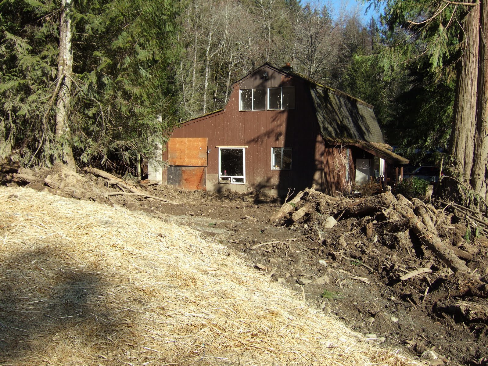
The Oliver debris flood in British Columbia has some similarities to a debris flood on an unnamed creek in Whatcom County that took place in January 2009. Homes on the alluvial fan were damaged and a highway was blocked. It also appears that both debris flows originated from impounded water high up in the watershed.

In the case of the debris flow in Whatcom County, the trigger was a failed stream crossing that held water backed up into a wetland. The failure took place during a rain on snow event. A fairly deep, low elevation snow pack had developed from several weeks of cold and snowy weather. A heavy rain storm then hit the area. This storm was a bit unusual in that it was a fairly cold rain so the areas with rapid snow melt were limited to lower elevations. Numerous landslides impacted the region with a concentrated area in the low mountains of Whatcom County.

The debris flow that blocked the highway was one of the more dramatic slides, but other slides in the area destroyed homes and roads as well. A few days after the debris flow I walked up the drainage to determine the cause. There were reports that recent logging and logging road construction had taken place in the area with the suggestion that this recent activity may have played a role.

The lower drainage just above the fan was very steep with vertical water falls over Chuckanut Formation sandstone. When I reached the recent clear cuts and logging road stream crossings, it was evident that the source of the debris flood was further up the slope. Three logging road stream crossings were destroyed by the debris flow. The source of the debris flow was not very dramatic relative to the impacts. A very old stream crossing in the upper watershed was simply missing. Immediately downstream the debris flows damage began. As the surge of water headed down the stream it picked up more debris and triggered additional erosion and slope failures. In places the debris flow ripped up chunks of bedrock.

Part of the debris deposit

Home hit by debris flow
Trailer damaged by debris
Home hit by debris, note the mud splashes on second story window
Lower logging road crossing
Middle logging road crossing

Trees buried and broken along stream course in a depositional, low gradient reach
Stream stripped down to bedrock
Ripped up bedrock along channel
Source of the trouble, failed stream crossing with road section missing
Just below failure, note height of bark stripped from the western red cedar trunk
Wetland that drained when road crossing failed

Abandoned and forgotten logging road stream crossings have long been identified as a source of stream damaging debris flow events. Steep streams such as this stream in Whatcom County are subject to debris flows. However, the frequency and magnitude of the debris flow events is increased by unnatural dams created by the old crossings. When these road crossings fail, the surge of water and sediment can be enough to create a moving debris flow that will travel all the way to the alluvial fan below. Besides impacts to structures on the alluvial fans, the greater frequency and magnitude of these debris flow events as been identified as a problem for salmon habitat.

In this stream’s case the volume of water behind the crossing was exceptionally large. Based on snow along the margins and on logs within the wetland, I estimated approximately one acre foot of water surged down the stream.

Monday, June 14, 2010

Debris Flow on a Sunny Day in Oliver, British Columbia


Photo - Richard Algurie special to Vancouver Sun

A debris flood came down a small creek near Oliver, British Columbia approximately 12 miles north of Washington State's border with Canada in the Okanagan Valley. Early reports indicate the debris flow may have been associated with a dam over topping or break at a small lake in the upper watershed of the creek.

The apex of the fan can readily be seen in the photo above where the creek exits the steep terrain onto the alluvial fan. As debris filled the the creek channel it spread out over the surface of the fan. Terraces along the sides of the Okanagan Valley can be seen on the hillside in the photo. The terraces are common features along the valley side and developed as the lobe of ice in the valley retreated to the north approximately 15,000 years ago.    

Photo - Spencer Whitney of Rustico Farms & Cellars. This photo shows that the muddy almost lava like nature of the mud flow on the lower part of the deposit.

Alluvial fans are geologically hazardous areas with risks consisting of debris flow/flood hazard, flood hazard, and erosion hazard. I took the picture below in the same valley on the Washington State side of the border. This fan is much steeper. A similar fan 600 feet to the north had a house on the central part of the fan. The take away message is that the small creeks associated with these alluvial fans are capable of behaving in a very dangerous manner and home and building site selection should take that into account.