Tuesday, May 31, 2016

Colorado River Water Woes

I have stopped at this Colorado River overlook twice in the past year:

Hite, Utah in May 2016

The River is just below the lip of the cliff in the picture. The structure in the center is the boat ramp. For a number of years this area was part of Lake Powell. But the lake levels have been under steady decline and Hite is no longer a viable boat launch site and has not been for several years.
Hite, Utah in September 2015

The Colorado River has been in the news of late because Lake Mead, the next lake down from Lake Powell has hit a low level that will begin to trigger a rethinking of the river management yet again.


And as can be seen in this graph, the long term water "budget" at Mead is not good under current use scenarios. Change will happen. It might have an impact on some the winter produce we enjoy.


An opinion piece on possibly discontinuation of Lake Powell ran in the NYT (nytimes.com/unplugging-the-colorado-river). I am not fully up on the nuances of the issue or the technical merits, but the overall usefulness of Lake Powell is in question with river levels so low. Besides the water management issue there is also a substantial change in perception of this area since the Glenn Canyon Dam was built. Both the downstream and upstream impacts have been significant. This issue is a very thorny problem with no easy solutions and I am fairly sure it is not so easy of a problem as the opinion piece suggests.

Brad Plumer provides an overview of just how bad the problem is getting at Lake Mead (vox.lake-mead-water-drought-southwest). Brad suggests links to one of my favorite writers on water issues, John Fleck. This piece by Fleck  (selling-colorado-river-deal-back-home-imperial-salton-sea-californias-hard-road) is a mix of technical, policy and politics and demonstrates that the Colorado River issue is rough going.

We have our own water struggles in Washington. Last year was a bit of a test on the resiliency of some of our water systems. But we do not have the poster images of desert and drained away lakes. Nor anything like the water structural deficit the users of the Colorado River have.

Tuesday, May 24, 2016

Lime Kiln on Orcas

An early resource extraction in Washington State was limestone. Limestone deposits were mined on Orcas Island and San Juan Island. The mines and associated kilns on San Juan Island are a bit better known as State Park, Lime Kiln State Park is located at the site. Kilns and small mines were also located at the upper end of East Sound southwest of what is now the Town of Eastsound (the town name runs the two words together). I came across one of the old kilns covered with English ivy.  


I know of at least two other kiln sites on Orcas. Another kiln site is located on San Juan Land Bank property at Judd Cove (sjclandbank.org/judd-cove-preserve-orcas-island) and is open to public access.

USGS topographic map indicating two kiln sites
The kiln shown above is not on the map

The limestone is in or were in three different formations: the Eastsound Group, the Deadman Bay Volcanics and the Orcas Chert. In all three cases the deposits are small in extent. However, the high carbonate content, access to water transport and abundant fuel (forests) for firing the kilns allowed for these small deposits to be profitable. There are scattered old quarry sites at many sites near the water on the island. The mining took place as early as the 1860s and was still in operation into the 1910s.


Monday, May 23, 2016

Two Different Erratics on Samish Island

I have found that my visual memory from past field work has lingered. I readily observe and notice certain rock features from past field work habits. While walking a gravel/cobble beach on Samish Island in Skagit County, I spotted small boulder among the thousands of other rocks on the beach.

Garnet and kyanite/sillimanite (and maybe andalusite psuedomorphs) schist

I spent a fair bit of time during a past geology work era looking for aluminum silicate schist. The whitish minerals in the rock are likely mostly kyanite with some sillimanite. And as noted might have once had andalusite that was replaced by the kyanite. These three minerals form under different pressure and temperature regimes with anadlusite being the lower temperature and pressure member, kyanite the high pressure member and sillimanite the high temperature member.


Identifying any of the three can give one a rough idea as to the pressure and temperature of the metamorphosed rock. And if you can identify the shape of one mineral such as the small crosses andalusite forms being replaced by say kyanite you can get an idea of the pressure/temperature path of metamorphism. Having the garnets in the mix can further help determine the pressure temperature path as the composition of the garnet shifts based on pressure and temperature as well. The core, central part of the garnet, will have a different composition than the rim. Hunting for this type of rock in the Coast Range of British Columbia or the crystalline core of the North Cascades took up a fair bit of my field time while working in those areas.

The boulder on the beach that I readily spotted would have been delivered via glacial ice from the high ranges of the BC Coast Range and may be from the same schist unit I once collected samples from.

I also spotted a much smaller erratic on Samish Island:
  
Dunite pebble

This pebble of dunite was not delivered by glacial ice. It had arrived via truck and was part of the gravel road I was walking. A pebble of dunite would not be a surprise given that many of the Skagit County gravel pits extract gravel deposited from an ice age river system that had some source material that came off of the Twin Sisters Range, a block of dunite within the Northwest Cascades. 

Saturday, May 21, 2016

Damming the Columbia: The Bonneville Landslide


I was curious about what the backup of the Columbia River would have looked like when the Bonneville Landslide at Bridge of the Gods blocked the Columbia River. In the DEM (digital elevation model) I set the blue color at 80 meters corresponding with the approximate top of the landslide deposit. The result is a long lake that extended well beyond the Columbia River Gorge and backed water up to approximately present day Umatilla, Oregon.

This assumes that the dam held up until it was nearly over topped. Lewis and Clark recognized the landslide when they traveled down the river having observed stumps from a previously drowned forest. They suggested the slide was 20 years old. The forest stumps were a well known feature of the lower Columbia River Gorge prior to the redrowning of the stumps when Bonneville Dam was built.


Pat Pringle gives a good overview of the slide complex with a discussion on the dates of the slide (bonneville_landslide_explorations.pdf). The slide is more likely about 550 years old based on carbon dates and tree rings.

(Randall, 2012) provides a more detailed characterization of the landslide complexes in this area. 

Wednesday, May 18, 2016

Fishhook Jim and Fishhook Park


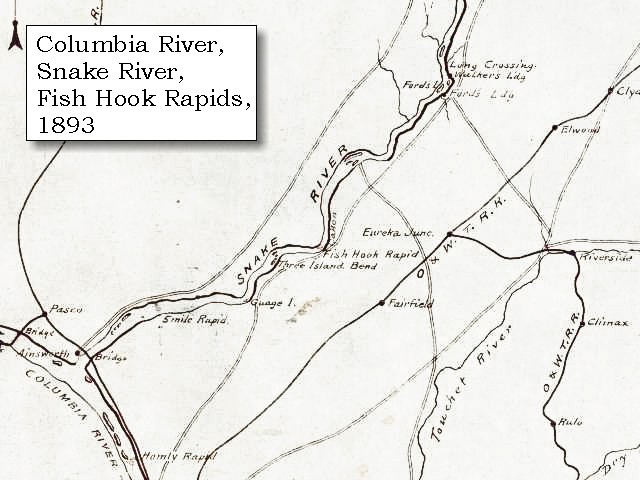
Fishhook Park is an Army Corp of Engineer Park on the shores of the impounded Snake River above Ice Harbor Dam. The park has camp sites, picnic areas, swimming areas and boating facilities associated with recreating on the lower Snake River. During a past era, I spent a fair bit of time on the lower Snake. In the summer the water is a lot warmer than the frigid Columbia.

The name Fishhook is derived from a rapids that was formerly located on this reach of the Snake River. But it also derived from a former resident, Fishhook Jim. I suspect his name was derived from the place.


Fishhook Jim was a Palouse Indian. The Palouse had relations and intermingled with many of the other tribes of the inland Pacific Northwest. The Palouse did not have a designated reservation in the Walla Walla Treaty of 1855. While some Palouse went to live on the Yakima, Nez Perce and Colville Reservations, many Palouse simply stayed put and continued to live along the Snake River with seasonal trips to other food source sites. Fishhook Jim was the descendant of Palouse Indians that stayed. Eventually nearly all the Palouse were forced to leave. A few managed to obtain homestead claims - a hard task for Indians that took the American path of land ownership. Frequently Indians were not allowed to claim land even if they opted not to go to the reservation. But for the few that did manage to stay, another blow came with the building of the dams on the lower Snake. The rapids at Fish Hook disappeared under the water as well as the ancestral village and gathering sites. It should be further added that several salmon species on the lower Snake were also finished off by the dams.

Fishhook Park is a reminder of a past time and a gesture by the dam builders to remember what was once there as well as the people that once lived for thousands of years on the lower Snake.

William Clark described the Corps of Discovery trip through Fish Hook Rapids:


"... A cool morning, deturmined to run the rapids ... [Clark, October 16, 1805]
Having examined the rapids], which we found more difficult than the report of the Indians had induced us to believe, we set out early, and putting our Indian guide in front, our smallest canoe next, and the rest in succession, began the descent: the passage proved to be very disagreeable; as there is a continuation of shoals extending from bank to bank for the distance of three miles, during which the channel is narrow and crooked, and obstructed by large rocks in every direction, so as to require great dexterity to avoid being dashed on them. We got through the rapids with no injury to any of the boats except the hindmost, which ran on a rock; but by the assistance of the other boats, and of the Indians who were very alert, she escaped, though the baggage she contained was wet.

Saturday, May 14, 2016

Non Washington: Aerial Notes from Nevada

Flying into Las Vegas, Nevada is a always a great treat for a geologist with a window seat or for anyone that appreciates landscapes.

A top highlight is the classic Keystone Thrust:


The older rocks of the layered limestone rocks of the gray Cambrian-age Bonanza Formation are overlying the buff to red sandstone of the younger Jurassic-age Aztec Formation. The older rocks were thrust up and over the younger rocks approximately 70 million years ago with an estimated crustal shortening of 60 miles. There are plenty of thrust faults in Washington State, but not nearly so well exposed and easily seen.

To the west of the thrust fault, the older rocks are also folded. Again demonstrating the crustal shortening or compression that took place in this area.


Geologic hazards are also readily observed, such as flood hazards. Nevada is full of alluvial fan areas with associated flood, erosion and sediment deposition hazards.

Dam and excavation on right to capture and hold water and sediment to protect Las Vegas development on the left.

Parhump has seen rapid residential development with very little regard to flood hazards associated with alluvial fans. The approach to development appears to have been build first and then solve the flood hazards after floods take place. Parhump experienced flooding in 1997 and twice in 2003 including flood waters as deep as 3 to 4 feet (Nevada Division of Water Resources, 2013).


Efforts to assess the hazards have included detailed mapping of piedmont and playa features (House, Buck and Ramelli, 2010). The broad fan below shows a variety of ages on its surface and illustrates the fact that alluvial fans are complicated and subject to change during flood or debris flood events.


The Las Vegas River has caused flooding and erosion in Las Vegas that has led to a variety of flood projects on the river. But given the drought risk that Las Vegas lives with, water in the river is a good thing. That water is actually waste water from the waste water treatment plant. The water is simply being returned to where it was drawn from.

Flowing water in the Las Vegas River

The long drought is evident when Lake Mead came into view.

Bath tub ring around Lake Mead on the Colorado River

Nevada is well know for mining. Part of the fun of flying over the state is mine spotting. Below is a the classic gold mine operation with heap leaching to extract the gold from the ore:

See SF's post for some geology and other references for this area

Nevada has non metal mines as well including mountain top mining for limestone and mountain top development.

Limestone mine outside of Las Vegas for cement production

Building pads for home development in south Las Vegas 

The biggest recent alteration of the landscape of Nevada the past few years has been huge solar farms:

Distant view of solar farm 

Friday, May 13, 2016

100 Years of Good Work

Capitol Reef Visitor Center

This year marks the 100th anniversary of the National Park Service. America's National Parks are something to be proud of, and we should be proud of the great park service that has served our parks and us so well. I paid a recent visit to a few of the parks in southern Utah. While I often seek out more remote places, I really enjoyed sharing some more visited sites with others.

Delicate Arch is not a place to go for solitude. I did have the site to myself the first time I visited it. A heavy snow storm brought about that lonely venture. The arch is a remarkable feature, and this time I very much enjoyed sharing the site with other hikers. One of the many great places to enjoy as a nation.
 

Saturday, May 7, 2016

Boulder Lag Beach

 
This shoreline stretch on the Salish Sea is nearly all boulders. Most of the boulders matched the local bedrock geology, but there are plenty of exotic boulders from far away places brought by the ice age glacier.
 
The source of the boulders is a glacial drift deposit along bluff above the beach.


Glacial drift with some stratification

Glacial drift directly deposited on bedrock

The shore has enough wave energy to removed the silt, sand and gravel from the beach leaving behind a lag of boulders. The headlands at bot ends of the beach were bedrock points. Any sand and small gravel had been transported into deep water off the points and outward from the boulder lag beach.

Thursday, May 5, 2016

Lummi Cloud Cap

A bit of cool wet weather reminding us we are in the Pacific Northwest still - not California. The ridge of Lummi Peak on Lummi Island is often capped with a cloud as the air rises 2,000 feet to pass over the ridge. Nice site as I headed out to adventures elsewhere.
 

Wednesday, May 4, 2016

Avalanche Hazard

Avalanche shoots in British Columbia

A geologic hazard that has been added to several county geologic hazard areas designations is avalanche hazards. With potential future development of mountain valley properties associated with winter recreation, it is not a bad idea to consider this risk. Ideally the hazard will be recognized prior to zoning changes that would allow homes or development in these areas.

The potential areas impacted in Washington State are pretty minimal. I took a look at this potential hazard for one county and found no areas of potential development areas that could be impacted presuming no radical shift in snow fall amounts on the lower elevation areas of the county.

With a few limited exceptions avalanche hazards in Washington State are outside of development areas. I encountered one site that had deposits of large wood, boulders and soil that were a bit perplexing because I was not thinking about avalanche hazard. A review of historic aerials helped. Although no avalanches were reported, the on the ground indicators of a were consistent with a past avalanche out of a high meadow 3,000 above that reached the valley floor. Avalanche hazard assessment requires some consideration of extreme weather events much like landslide hazards, alluvial fan hazards and flood hazards.

Tuesday, May 3, 2016

Rock Fall and Root Throw


Assessing potential rock fall hazard on a slope meant taking a careful look at how the rock was weathering and joint patterns on cliff faces. Could this cliff spall off a large boulder? How much energy and momentum would a worse case rock fall have? What are the potential pathways of rock falls? What kind of material will the rocks encounter on the slope below? Will a rock fall maintain energy and speed while rolling or bouncing down the slope?

In assessing the cliff, I noted a rather loose boulder perched on the edge partially supported by a big leaf maple tree. My initial thought was that the tree had stopped a boulder from a cliff that was higher up the slope above the lower cliff area I was investigating.


In fact there was no cliff source area for the boulder. The slope above the cliff was a long flat area with absolutely no risk of rock fall. 

After a little thinking, I concluded that the precariously perched boulder got pulled up out of the ground some time in the past when a tree, now gone, (perhaps an earlier version of the big leaf maple) fell over. 

An example is this toppled tree that yanked a angular block of rock out of the ground and plopped it on the moss and brush. It is striking that such a modest looking tree has the root strength to pull out such a large rock from the bedrock below.

Monday, May 2, 2016

Seismic Retrofit

Last month I was involved in a remodel project of an old masonry constructed building. It is a very cool project and my involvement was limited to the potentially bad news part - seismic hazards and foundation bearing of the underlying soils. The solutions to the seismic and structural part are up to the structural engineer. The news we delivered regarding foundation loads and potential liquefaction made a huge difference in terms of costs. Hence, there was some anxiousness on the part of the project team. Part of the project did require steel support to upgrade the anticipated seismic/structural loads.
  

The site pictured above was not the project. I did not suggest this exterior steel support. The above retrofit project for a multi story school was apparently the most appropriate cost effective approach for the site conditions. More often seismic retrofit projects are not so visible. Perhaps a good constant educational reminder for the students at this school about geologic hazards.