Friday, February 28, 2014

Further Update on The Nooksack River/Clay Bank Landslide Via DT

Dave Tucker and a couple associates took a trip out to the Clay Banks landslide complex on the Nooksack River Thursday, and Dave put together some very good descriptions as well as some marked up photographs of the slide nooksack-river-landslide-update-2. In particular he notes the blocking slide came from the upper half of the bluff.
I had a couple of previous posts on this slide complex event (nooksack-river-temporarily-blocked and nooksack-river-blocking-landslide-notes).
I'll probably be revisiting this landslide in future posts, but in the mean time Dave's descriptions are an important point in time documentation of the slide. With the fresh exposures on the slide complex, it may be worth putting some effort into understanding the mechanics of this slide.
 

Tuesday, February 25, 2014

Seahawk Mask

Post updates via Dave (thanks) and Burke Museum

An Early Seahawk Fan

Came across this Pacific Northwest mask at the National Museum of the American Indian. The mask was made by coastal First Nations people in approximately 1890.

Juxtapose the positive incorporation of pride in Pacific Northwest heritage and the Seattle Seahawk image with the Washington Redskins is a bit jarring. Of course the naming of the teams and the logo development of the two teams were done generations apart. But sometimes it is best to let old traditions go away.

The Burcke Museum did some research on the Seahawk logo Searching for what inspired the Seahawk logo and the likely mask Mask that likely inspired Seahawks logo.

I do know that there is great pride in the Seattle Seahawks by Washington State First Nations. Marshawn Lynch, the Seattle running back of few words to the media enjoyed a First Nations' drum at the Superbowl celebration parade.

Monday, February 24, 2014

Bellingham Snow: The Pride and the Shame

View towards downtown Bellingham

A point of pride for Whatcom County is the periodic micro climate cold weather events. For most of the winter, Whatcom County and Bellingham are very much the same as the rest of western Washington. But if cold air and high pressure builds up in the British Columbia interior, Whatcom County's weather and to a lesser extent the San Juans and north coast of the Olympic Peninsula will have weather markedly different than the rest of western Washington.

This weekend and continuing into today fit that difference. Even Cliff Mass put up a hyperbole headline bellingham-and-environs-is-buried-in-snow and provides a description of the snow event. A comment on the post by Colleen sums up the micro climate, "Left Lakewood around noon, driving back to north Whatcom County. When we hit the road it was 45 degrees with no precipitation. Light rain in Tacoma. Heavier rain through Seattle and Everett. Swirling snowflakes and light wind in Mount Vernon. Real snow and wind in Bellingham with somewhat messy roads. Problems really began north of B'ham due to the northeaster and accompanying snow drifts. By the time I reached our place in Lynden the drifts were already 4 feet high. Definitely qualifies as one of our more notable "blizzards" of late, though it would take much more snow, over a longer period of time, to rank big time."      

Even this morning the cold temperatures were hanging in Whatcom County. NWS noted the pressure difference between interior BC and Bellingham is still strong enough to keep the clod interior air flowing:

SNOW WILL FALL AT TIMES UP IN THE FRASER OUTFLOW OVER WRN WHATCOM COUNTY. THAT WILL BE CHANGING TO WET SNOW THEN RAIN...BUT BLI-YWL IS -14.5MB AT 8AM AND A WINTER STORM WARNING IS STILL IN EFFECT FOR WRN WHATCOM COUNTY TODAY.
 
Fortunately the shame part of the snow event will be short. Despite the more frequent and large snows in Bellingham relative to the rest of western Washington, very little sidewalk clearing takes place. Hence, my walk to the office this morning was a bit hampered and the walk home though deep slush and ice pickled my feet. Partly irritating as I walked by 4 parking lots cleared of snow, but with the sidewalks left. 
 
 Perhaps it is because I was born in New Hampshire and lived for a time in the Midwest that my attitude towards what one does when it snows is a bit different that most Bellinghamhasters.
 
Stratum Group office at Haleck and Young - Winter 2012 
"Blessed are the snow shovellers, for they are kind to pedestrians" - Lisa, Winter 2014.


Sunday, February 23, 2014

Nooksack River Blocking Landslide Notes and Pictures

As a follow up on Friday's post (nooksack-river-temporarily-blocked) I did get out to the newest Clay Bank Landslide downstream of Deming yesterday afternoon. One of those chances to get out and learn a few lessons. Dave Tucker got out there as well and got a different view angle than what I have and has some images from above the slide area on the south side of the river nwgeology.2014/02/22/landslide-diverts-nooksack-river-near-deming-washington/.
 
I will add there is some interest in this event as it is not a common thing to have the flow in a river shut off even for a short while. On the good news side, the river riparian area is wide enough that though the slide temporarily blocked flow and diverted the river, the blockage and diversion did not threaten any homes or infrastructure.
 
First a little background as to location and river dynamics.
 
Aerial view (USGS, 2009)
River is flowing from the right to the left (east to west)

Topographic Map (USGS)
The slope where the landslide took place is marked and is approximately 120 feet high

The Nooksack River Reach between Deming and the highway bridge has been and is rather dynamic with significant channel migration. The dynamic nature of the river continues further to the west as well. During big floods in 1990 on this river reach, the river channel shifted as much as 1,000 feet near Deming in a single flood event and the river took out the State Highway bridge.

But even without major floods the Nooksack near the Clay Banks where the slide took place has done a lot of shifting over the past 15 years. That channel migration is illustrated with the following Google Earth images.

1998 with future landslide marked and channel marked with green line (click on picture to enlarge and better see the line)
 
In 1998 the river was hard up against a rock rip rap levee on the north side of the river. That rock lined levee prevented the river channel from migrating northward and turned the river back to the south towards the Clay Banks west of the most recent landslide. The levee was constructed in the mid 1990s. By 1998 landslides had begun on the Clay Banks as the river was flowing hard against the base of the slope at that time. 

2005
 
By 2005 the river channel in the vicinity had shifted significantly and was no longer flowing along the levee to the north. Note the wide swath of trees that had been located between the future landslide site and the river in 1998 had been nearly all removed.

2006

Even in one year between 2005 and 2006 the river had shifted and significant land sliding had taken place at the Clay Banks and was beginning to threaten a home that had originally been located 300 feet from the edge of the slope.

2011

By 2011 the river channel shifts are such that the river is flowing at a right angle into the location of the future landslide. By this time the area of landslides to the west was beginning to become vegetated with red alder, but alas the home had fallen down onto the slope.

Oblique aerial view of landslide area (2009)

At the time of the oblique image the lower part of the slope was clearly being eroded and was steep, but the upper slope was still tree covered. The older landslides were still recently active downstream.

Images and notes from my February 22, 2014 visit.

View of the Clay Banks from the northeast

Older slide area with home collapsed onto the slide


Most recent slide area and river blocking slide
Note large blocks of clay on landslide deposit

Very narrow new channel in front of landslide deposit.
 
I estimated the channel as being 50 feet wide. In contrast to the width elsewhere I took this picture of the river upstream of the site.
 
Much wider river channel upstream

There is a bit of a pool of slow water above the constriction caused by the landslide deposit.

The above image also shows some of the geologic structure relevant to the landslides. The slide that blocked the river came from the upper bluff. This upper bluff section is glacial drift. A sand layer is below the glacial drift and seeps of water can be seen flowing across the lower bluff. The lower bluff is also glacial drift. Easterbrook (1960s) has interpreted these units from top to bottom as Bellingham glacial marine drift, Deming sand and Kulshan glacial marine drift. I've never been able to take a really good look at these units at this location. Given the much improved exposures it may be a worthwhile exploration for interpreting the late glacial history of the area.

Large blocks of clay from the slope failure

Note this block of clay is on my side of the river across from the landslide

I made a few notes of where blocks of glacial drift were located across the river from the main landslide deposit. The furthest I observed were 150 feet from the new main channel.

Closer view of glacial marine drift block

Classic pebble of diorite pebble embedded within the clay matrix
The clay was soft indicative but not entirely definitive of glacial marine drift versus till as till is more typically hard due to compaction by ice.

The most distal clay blocks I observed

One noteworthy feature was the broad swath of wood deposited upstream of the slide area. Perhaps not unusual along the river, but I saw no similar swaths of wood in any of the aerial images including the high resolution oblique images of the river (see aerials above). What I suspect is that as the water backed up across the riparian area immediately after the flow was temporarily blocked and wood over a relative large area was floated and then grounded as the water began to surge across the wide shallow area to the north of the slide blockage. There were indications of very recent sheet flow across all the area downstream of the wood covered area.
Swath of wood accumulated along the head of the overflow path above the slide blockage 
 
Bent over grasses with cobble deposition over the grass in upper left.
Water would have flowed over a broad swath as a sheet prior to the new channel being cut downward just beyond the main landslide deposition area


More of the sheet flow area and a pre existing small side channel
There is a deer standing in the water in the center of the image.
 
The deer had come running out of the woods and down the side channel straight toward me. Something was back in the woods it was keen on getting away from.
 

Friday, February 21, 2014

Nooksack River Temporarily Blocked by Landslide

Via a network of folks that pay attention to the Nooksack River. The flow on the river at the Cedarville gage took a brief plunge last night from 2,300 cfs to 400 cfs.  
 

At Lynden 11 miles downstream a less substantive, but still sharp drop and recovery took place. Lynden Public works reported a sharp increase in river turbidity.
 USGS staff noted the dip in the discharge and Whatcom Flood Division confirmed a large landslide at the Clay Banks had blocked the current main channel and deflected the river back to an older channel.


Clay Banks landslide can be seen at bottom center

Topo of Nooksack River and Clay Bank

No pictures of the slide as I was away and am away from my old pictures of the slide. Hope to get out there soon. As can be seen the river has been up against the steep bluff in the past. However, the frequency and duration of the river being against the steep bluff has been enhanced by the construction of a high rip rap levee on the opposite bank preventing the natural meander of the river.

1998
Note the slide on lower left and rock levee on the opposite upstream bank

The clay of the Clay Banks is glacial marine drift silts and clays deposited during the late stages of the last glacial period.

Thursday, February 20, 2014

Notes on East Sound Group, Northeast Shore of Orcas


East Sound bedrock on the northeast Orcas Island coast

I had a chance to look at a fairly continuous set of outcrops of the East Sound Group along a portion of the northeast shore of Orcas Island. Bedrock outcrops of East Sound Group rocks are common throughout the northern areas of Orcas; however, the northern most shore area is the much younger Nanaimo Formation. 

Erosion resistant volcaniclastic unit

My observations of East Sound Group rocks has been a bit biased. Inland site outcrops tend to be predominantly hard competent bedrock consisting of massive metamorphosed volcaniclastic units. However, there are softer shale units and significant fault/shear zones. Some of those shear zones are related to landslides and unstable slopes. Hence, as part of my geohazard work I have spent some time with these rocks and gained an appreciation of potential hazards. This shoreline traverse provided a chance to see a bit better exposure of some of the more sheared units.

Mangled tuff? unit in highly sheared shale unit

 Highly sheared bedrock within fault zone
  
Brandon, Cowan and Vance (1988) coined the name of this unit as it crops out at East Sound, a fjord-like bay on Orcas Island. (Note the town at the head of the bay is spelled Eastsound.)  Lapen (2000) references age dates as old as the Devonian (400 million years or so). Brown, Hausen and Schermer (2007) (wwu.edu/bernieh/reprints/brown-gsa-cord-07-san-juans.pdf) suggest these rocks formed as part of an volcanic island arc as the unit consists of volcanic related sediments, volcanic rocks are present as well as cherts and limestones. Another similar age formation to the south, the Turtleback Formation has been interpreted as igneous intrusive part of the ancient island arc.

This set of island arc rocks was later accreted onto the west coast of North America. Where that accretion took place and what happened to these rocks after accretion has been the subject of wildly divergent interpretations. I am in Western Washington University Camp that has the accretion way to the south, followed by northward transport and then a sort of second accretion as the terrains encountered the south end of Vancouver Island (a previous accreted terrain called Wrangellia) that was at the time a westward protrusion along the North American margin. .   

The East Sound Group is one of several tectonic slices of accreted terrains in the San Juan Islands. It is thought to be the bottom of the pile of the San Juan-Northwest Cascades thrust system. Somewhere a bit north of Orcas or somewhere under the north shore area of Orcas is the footwall at the base of this thrust system. Alas this fault zone and footwall are not exposed.  

Cross-section of Orcas Island (from Brown and others, 2007)
ES=East Sound Group, TB=Turtleback, OC=Orcas Chert, CO=Constitution Formation, GA=Garrison Schist, C=Fidalgo Complex are all part of the San Juan thrust system.
HS=Haro Formation is part of the footwall of the thrust pile.
NA=Naniamo Formation - back thrusted? over the San Juan thrust package but then eroded. 

Block of highly deformed chert and tuff with sheared shales and sandstone wrapping around the block

One of the challenges of interpreting the San Juan thrust pile is that these rocks have gone though multiple deformations. One can look at one outcrop and see southwest directed thrusting and another will show northeast thrusting. Throw in that these rocks have gone through some post thrust emplacement deformation and it gets complicated fast and opens up possible multiple interpretations. Even within the small reach of shoreline exposures I observed there appeared to be multiple shear zone types that are of various ages. These rocks will require a great deal more prodding to decipher.


Monday, February 17, 2014

Keystone Thrust: Notes from my meandering

Some great geology views while traveling including this great view of the Keystone Thrust Fault.   

The older rocks of the layered limestone rocks of the gray Cambrian-age Bonanza Formation are overlying the buff to red sandstone of the younger Jurassic-age Aztec Formation. The older rocks were thrust up and over the younger rocks approximately 70 million years ago with an estimated crustal shortening of 60 miles.

There are plenty of thrust faults in Washington State, but not nearly so well exposed and easily seen. Amongst geologist this thrust fault is a famous location. Something to look for when you head into or out of Las Vegas, Nevada.

In my case I was just flying over the area. And, no, I was not on a get-a-way-from-winter trip. We had all of 1/2 hour in Phoenix between colder locations.

One other note as the great Southwest Drought has been in the news. Mount Charleston approximately 25 miles west northwest of Las Vegas had a very thin dusting of snow. Not good given that it was early February, and it took me a bit to convince myself I was indeed looking at Charleston. I have been on the 12,000-foot ridge of Charleston in late May and seen more snow.

Sunday, February 16, 2014

Some Music for the Week: Typhoon and Ritter

A bit short on blog content... travel, work, field work and family.
I missed Typhoon's passage through Washington State but did get to see Josh Ritter in Seattle.
Typhoon is out of Portland and Ritter is from Moscow, ID.

I do like this song from Typhoon's latest release. Complex with sharp changes and might not be for everyone, but give it a try.


Josh Ritter played for over 2 hours. Always a good show and this song reminds me that simple things make "heaven and earth pretty much the same". His mention of driving through Washtucna drew a cheer.

Thursday, February 13, 2014

Avalanche Clip

Came across this rather unusual video of an avalanche. The avalanche shown starts off in the typical billowy pattern of snow rushing at high speeds down a steep mountain slope but then morphs into a rather unique ice movement that is highly destructive.

 
While avalanches do kill too many people in Washington State, most of the hazard is in the back country in areas where cross-country skiers, snowshoe, and snowmobile enthusiasts enter risky areas. The mountain passes and ski areas are routinely monitored and purposeful avalanches are triggered to greatly reduce the risk. In he case of the passes over the North Cascades and Cayuse Pass that hazard is reduced by simply shutting  the passes for the winter.
 
I have had only one project in Washington State that involved avalanche hazards to home sites. The site was identified as an alluvial fan hazard area. I began the assessment with the idea that the hazard was debris flows down a stream channel. A review of areas on ground of the fan and up the stream did not fit the debris flow model, but infrequent avalanches did. I was not able nor was it necessary to work out a potential frequency of the event. The avalanche shown in the video would have a very low frequency, hence the houses. But that is the nature of hazard assessment - thinking in terms of worse case scenarios.
 

Tuesday, February 11, 2014

Coal: Notes from Northwest New Mexico

The Seahawks have given us Washingtonians a subject to have been obsessed about besides coal. When I first saw this view it reminded me of some mangled letters one sees when commenting on blogs to prove your not a robot.

Surface coal mine southeast of Gallop, New Mexico 

The Powder River (geologic basin) is not the only coal mine area in the west. Northwest New Mexico has extensive surface coal mines. Numerous active mines are located in this area and have been as long as I have been doing geology work.

If you look closely, one can see the rail line that leads from the mine. The mine is the Lee Ranch Mine owned by Peabody Coal. Most if not all the coal from this mine as well as a number of others in the region supply coal to numerous coal fired electric power plants that feed electrons into the electric grid of the southwest U.S. By way of example, the Escalante power plant outside of Pert, NM is located about 35 miles from this mine and has a long term contract for the Lee Ranch coal and supplies electric power to group of public utilities extending from Arizona to Nebraska.

It will take a long time to for this region to transition from coal as there multiple coal power plants and multiple mines as well as extensive electric transmission lines. That said, the electric transmission lines provide a ready source for transmitting wind and solar energy from this region.

Coal power generation in this region has not been without controversy. This was a region with remarkably clear air prior to the multiple power plant projects in the region and there has been loss of air clarity compared to pre coal days.    

Monday, February 10, 2014

Notes from Northeast New Mexico

I was away from Washington State for a bit so a non Washington State post. I had some nice aerial views of a landscape I kind of like in northeast New Mexico. The high plains disrupted by abrupt canyons.

Ute Creek

Tramperos Canyon on the lower right and lots of ponds in the plain

The ponds are formed on the thin soils overlying the Ogallala Formation. This formation covers a fair bit of this portion of the high plains and has rather thick calcretes in the upper part of the formation. Calcretes form by precipitation of calcite within the soil forming a hard pan. It is a slow process that is common in semi arid landscapes and creates a hard pan. In this case places where water can stand as a perched layer. Calcrete can be a good aggregate for roads and building.

Northeast New Mexico at the ground level

The ponds are important for the grazing lands and the canyons are places of shelter.

This was former Comanche Land. A visit to this area makes it easy to understand why the Comanche completely stymied the Spanish for well over 100 years and Americans for roughly 50 years (comanchie-context-to-yakama-war). It was not until the bison herds were destroyed and US military went out and attacked the canyon homes of the Comanche bands that Comanche lost most of their home land. 


Saturday, February 8, 2014

Crescent Formation at Hood Canal

I had a little engineering geology project along Hood Canal that had a nice exposure of former ocean floor lava. The lava was a mix of breccia blocks of basalt and pillows. The breccia is from rubble of broken fragments of lava and the pillows are places where the lava pulsed out into the water forming a pillow-like shape. The rubble-like deposits were easy to see. I was rather unsuccessful at capturing any pillow pictures - the exposure, light and contrast has to be just right.  
 
Crescent Formation lava
 
Glassy rim of pillow

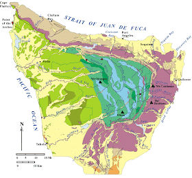
The lava is part of the Crescent Formation, a broad and thick lava unit that was mostly an undersea formation. Not dissimilar to the sea floor lavas that erupt from ocean spreading centers off the Washington and Oregon coasts today. However, the amount of magma in the Crescent was so great some of it flowed out above sea level - perhaps something like Iceland toady. For some reason the spreading ridge magma that formed the Crescent, like Iceland, got an extra surge of magma. One idea is it was augmented by a nearby hot spot magma plume.

This former Ocean floor has been accreted to the edge of North America. It has since been folded and bent as more ocean floor sediments have been stacked up and thrust under the Crescent. The Crescent forms a crescent shaped outcrop pattern on geologic maps, but its name is derived fro Crescent Bay along the shore of the Strait of Juan de Fuca.

Olympic Peninsula geologic map (USGS)
Crescent Formation is the purple unit.
Greenish units are younger slices of ocean floor sediments thrust under and against the older Crescent
  

Thursday, February 6, 2014

Slogging Through Beach Sand

I found my pace slowed by remarkable sand compaction on a shore near Langley on Whidbey Island. With each step my foot would sink a good two to three inches or more into the beach. 
 
Deep foot prints on the beach

Being slowed by sand is to be expected when the sand is loose and dry. But in this case the moisture content and grain size distribution was such that significant compaction was taking place by simply stepping on the beach. The beach sand all along this reach of shore was the same and made for a rather awkward gait. I generally drift to the beach material with the easiest walking, but this sand was nearly uniformly distributed across the beach and wet areas meant sinking into water.

The geology along this shore reach was rather uniform as well. Shoreline bluffs of advance outwash sands deposited as the Puget ice lobe advanced into the area and then overrode the sand with some silt. The unit above the advance outwash was a recessional glacial outwash with an almost identical grain size, at least on a casual visual basis. There was no intervening glacial till, but the recessional outwash sand having not been overridden by ice were looser. 

Advance outwash sands and silty sand, Whidbey Island

Tuesday, February 4, 2014

Facing the Fraser Outflow from Orcas

I had a nice face-off with the Fraser outflow winds today. The ferry to Orcas had closed the upper deck and requested folks stay seated when crossing Rosario Strait. My first project was on the south side of the island with sun and protection from the northeast wind.
 
I then headed over to the northeast shore area of Orcas in direct line with the winds that flow out of the Fraser Valley across northern Whatcom County across Rosario Strait.
 
Facing northeast into the wind. The North Cascades were obscured with foothill snow flurries where the Arctic air was flowing out into the low lands
 
Path of Arctic air out the Fraser Valley
 
View southeast down the northeast shore of Orcas with Lummi Island in the distance
 
The scramble down the steep rocky cliffs and scree slopes to the shore was a test of my cold weather scramble skills. The usual give to the ground was gone as the soil was deeply frozen on this northeast slope in direct line with the cold wind so foot purchase was less than normal. Fingers can't be as effectively sunk into the dirt around roots and normally reliable sticks and branches become brittle when frozen.
  
But great scenery, wild solitude (not sure this shore gets many visitors and certainly not with a Fraser outflow), some very interesting geology and a full on experience of this micro climate.
 
I turned back here leaving the gulls in peace on this cold day.