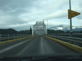
After a visit to Multnomah Falls icy-multnomah-falls, I headed up to the Bidge of the Gods.

Bridge at Bridge of the Gods
The steel framed two lane bridge pictured above crosses the Columbia River at the Bridge of the Gods. The Bridge of the Gods is from a local Indian story about a natural bridge located across the Columbia River at this location. Lewis and Clark heard this story from the local Indians during their journey both down and up the Columbia River in 1805 and 1806. They observed that there were dead standing trees in the river upstream of the this location and surmised that the river had been dammed at this location by a landslide. Turns out they were right; a huge landslide had blocked the river. The Washington side of the river pictured above is a landslide deposit and the landslide scarp consists of the partially snow covered slopes in the distance. The landslide covers and area of approximately 5 square miles.
The local Indian stories that survived place this gigantic landslide as one of the earliest recorded historic events in Washington. Giant slides like this one likely had multiple failures, but recent work suggests a mid 1400s date for the slide. Pat Pringle provides a nice summary of the work that has been done bonneville_landslide_explorations.pdf.

Bridge at Bridge of the Gods with a great view of part of the head wall scarp of the landslide
It costs a buck to cross the bridge. The bridge is narrow with a steel deck and a speed limit of 15 MPH. This gives one a chance to glance at a bit of history of this historic place.

View to the east up the river at one of the old locks.
The Indian story that the landslide blocked the river is convincing. At this location the river is narrow and confined. But it used to be even more narrow. Bonneville Dam downstream from the Bridge of the Gods has backed the river up. Prior to the dam navigation at this spot was nearly impossible and generally required portage even for canoes. The site was an important trading center as the portage was difficult and would often require assistance from local Indians. During early American settlement the old giant land slide restriction on the river brought misery to several tired pioneer groups at the end of the journey. This lead to development of new routes to avoid this section and go overland to the Willamette Valley. But river transport was important and in the late 1800s a series of locks were constructed to transport barges up and own the river safely. All but one of these locks were submerged by the waters backed up by Bonneville Dam in 1938. That easternmost lock can be seen from the bridge.

Fishing platforms along shore west of the bridge
With the narrow river channel this location was also an excellent fishing location for netting salmon as well as other fish and eels in the river. Several tribes continue to utilize this site and a few platforms can be seen out over the river on the Washington side.
Some years ago I walked over this bridge while hitchhiking the Gorge. It was quite a thing to see the river flowing through the steel grates.
ReplyDelete