Saturday, October 18, 2014

Notes From Detroit

I have been traveling and I am still digesting my time in Detroit. I am not unused to seeing areas that are a bit on the downside. But the scale and the demographic and economic realities of Detroit are still taking awhile to settle in. The thing to keep in mind about Detroit is that its population has declined to approximately 36% of its peak population of 1.8 million in 1950 to less than 700,000 today with a drop of over 200,000 since 2009.
 
So some notes mostly in pictures. I'll put up some positive stuff later.
 

A pioneer spirit despite being on the same street as the homes shown in the first picture


Empty buildings and lots and note the gutted street lights

Scrapping buildings can be hazardous

Th famous and sad Michigan Central Station building http://en.wikipedia.org/wiki/Michigan_Central_Station

Central Station from a different angle

The Book Tower on the left has been completely vacant since 2009

Pedestrian overpass from parking garage to the Book Tower

Geese on an urban street. Grass area was formerly home sites now long gone
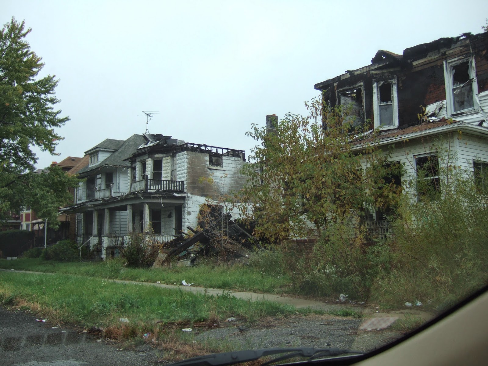
Fairly typical scenes in many neighborhoods


Quiet open space area was formerly all urban density homes

A street that has lost all its homes

The nearby arterial street has lost all its shops but not the buildings

Boarded up but still in good shape
Typical listings for homes like this one were between $5,000 and $15,000 and seemed to be mostly dependent on the condition of the neighboring homes

Truck garden and green house on what had been a fully urban street

The level of abandonment is not captured above. There were miles of streets with far more burned out or vacant homes and apartments throughout multiple neighborhoods.

Planning challenges markedly different than the  planning challenges facing most Washington State cities. Where Washington State's Growth Management Act requires planning costs of infrastructure for growing population, Detroit is now having to consider the cost of maintaining urban level services to areas that have been and are continuing to go through negative growth. A difficult challenge as tax base declines. There are some lessons here - just hard to think through.   

Sunday, October 12, 2014

Osprey Bailing Twine Problem Near Ellensburg


I had heard reports of ospreys having the bad habit of collecting bailing twin in their nests fatal-attraction-ospreys-bind-baling-twine-fishing-line. I spotted this osprey nest on a platform built for providing a nest site west of Ellensburg on the broad Manastash alluvial fan. The platform is located within an area of extensive irrigated hay and hence, lots of available twine wrapped into the nest.  As reported in the NPR piece I heard, there has been an effort in Montana to reduce this problem and it clearly is a problem in Kittitas County as well. 

Thursday, October 9, 2014

A Break from the CRBG - Violent Ellensburg Formation

A recent day of field work which mostly entailed navigating complex topography to get to where I needed go had lots of basalt outcrops of the Grande Ronde basalt member of the Columbia River Basalt Group (CRBG). The Grande Ronde is the most massive of the lava flows that make up the CRBG. The two flow sections I was navigating through west of the Kittitas Valley are interpreted by Tabor and others (1982) on the Wenatchee 1:100,000 geology map as two upper flows of the Grande Ronde based on stratigraphic position and polarity of the iron minerals in the flow. These are the same flows that are exposed in the bottom off the Grande Ronde River Canyon in the southeast corner of the state grande-ronde-basalts-at-grand-ronde.  

Cliffs of basalt 

Top of cliff

Scree of weathered basalt

My entire day was occupied looking at rather uniform basalt cliffs, scree slopes and thin soils full of fractured basalt. But at the very end of the day I came across something new - an exposure of welded hard volcanic material full of bits of rock fragments firmly embedded within a finer matrix. My initial though before taking a closer look was it was glacial till.


The Tabor and others (1982) map indicates Ellensburg Formation volcanics about a mile to the east. This exposure fits the Ellensburg Formation from the area. The Ellensburg Formation does interfinger with CRBG meaning that when the early massive CRBG flood basalts flowed across southern Washington approximatley 16 million years ago there was also a rather violent separate volcanic field in the area with explosive eruptions. Some of the explosive eruptions can be viewed along Highway 10 northwest of Ellensburg ellensburg-formation-side-trip  

Wednesday, October 8, 2014

Some Gold in the Fall: Cottonwood and Western Larch

I met some trees with character the last few days, and a few were presenting golden colors that enhanced their presence. 


This large cottonwood along with a few smaller mates occupies a small unnamed canyon in the deeply eroded table lands west of Ellensburg. Its gold color and fluttering leaves were an attractive site. It was a hot day for October and the cool of the canyon stream was appealing, but I had some ground I needed to cover so I stayed up high and took a route around the upper canyon versus the steep cliffy slopes.


This western larch stood along in a rubble field of fractured hard basalt. This particular larch had turned color ahead of the other larch in the area. Larch are conifers hat loose their needles in the fall.

Larch are the predominant tree in parts of the drier and higher parts of the North Cascade crest, but also show up in stands on the colder parts of the east slopes of the Cascades such as this one on the upper Manastash Canyon west of Ellensburg. This particular site is at elevation 4,000 feet. Larch also cover large tracts of the high mountains in north central Washington such as along Highway 20 east of Republic in the Kettle Range.

Tuesday, October 7, 2014

Semi Dry Tomatoes

The warm summer and continued warm fall has led to perhaps our biggest bumper crop of tomatoes. I have a good spot to grow them above the rock retaining wall above the alley. Growing tomatoes in the cool of western Washington is a challenge, and a bit extra so in Bellingham - a bit cooler than most other locales. Some of the plants are completely done, but we have a few that continue to produce well until it really gets to cold and dark. So when home I do a simple process to preserve them.


I cut them up and lay them out on trays with a light coating of olive oil (sometimes I use the left over oil from Lisa's preserved of zucchini jars). Slide the trays into the oven and heat to 220 F for 3 hours. Turn the oven off and in the morning slide the slightly dried tomatoes into baggies and freeze. The concentrated flavor and loss of excess water makes them just right for an instant sauce. A fast method versus making sauce and a great way to deal with a few pounds at a time.

Ready to bag after partial dry

Friday, October 3, 2014

Oso/Hazel Follow up by KUOW and Dan Miller Visits my Old Field Area

KUOW has been doing a series of stories on the Oso slide. One with a bit by Dan Miller is HERE. And the video associated with it:


Miller wrote and published reports as well as a paper on the Hazel (later Oso) landslide. The work was important in that he and his coauthors developed an approach to assessing ground water recharge to deep-seated glacial related landslides. That work as well as the fact the slide blocked the Stillaguamish River in 2006, was why many geologists were well aware of the potential risk of the Hazel landslide. I assessed groundwater recharge to landslide areas on other projects and have generally followed the policy struggles on how to deal with ground water recharge to deep-seated landslide in terms of forestry, and hence, am familiar with Miller's work.

An interesting bit about the video is that it is it was filmed in my graduate research area. I was not paying much attention to slope issues and debris flows as Miller is doing - my work was on the granite rock he is filmed walking around on. The area is below a glacial area and the glaciers have retreated exposing bare rock and leaving behind piles of glacial moraine material. The area in the video is also subject to avalanche - the knocked down trees of various ages shown in the clip. Between my first and second field seasons a particularly large avalanche tore down the slope splintering old growth cedar forest.

Avalanche deposit at Cascade River Road

 The road to the Cascade Pass trail head below this area has been a challenge to keep open.