Observations of Washington State Landscapes, Geology, Geography, Ecology, History and Land Use
Saturday, October 31, 2020
Typhoon - Welcome to the Endgame
Friday, October 23, 2020
The Sounds of October
This is my second October living full time at our current home. October is a month of change. Yes, the colors change. Maybe golden leaves on the the big leaf maples. The initial fall rains flipped the brown grass to green.
But the big change that has gotten my attention are the sounds: 1) The early rains brings out frogs. The tree frogs begin some chorus activity before the colder air shuts things down again - no calls tonight as the temperature is down in the 30s and perhaps 20s by morning. 2) One of the abrupt sound changes is the early just as it gets light sound of guns. Our home is near tracts of State Fish and Wildlife lands as well as a hunting club property and farmland that allows hunting. October brings hunters to sit in blinds awaiting ducks and geese as well as a few pheasant hunters that venture to the brushy thickets between fields. I picture them sipping coffee or whiskey waiting for the ducks or geese to fly near. 3) Another abrupt change is the roar of wind through the forests west and south of us. This evening the wind is coming out of the north - calm around the house but very audible from the upper tree canopy. When the wind really cranks up from the south, a flute like sound emanates from the east side of the house. 4) My favorite is the great horned owls calling in the forest at night. 5) The massive flocks of snow geese honking overhead a week ago in the early morning made me think "welcome back from Siberia".
Wednesday, October 21, 2020
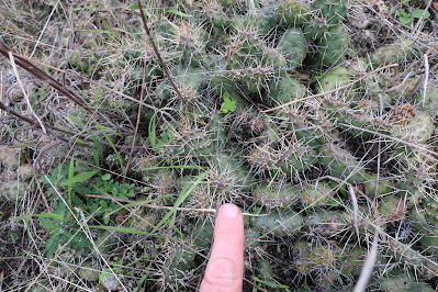
An Unexpected Encounter with Opunntia fragillis
It is a pretty rare plant in western Washington and is limited to the Olympic rain shadow with reports of the cactus on Whidbey Island and northwest Jefferson County on the Olympic Peninsula. This species is also present in the Okanogan area of north central Washington along with a couple of other species of cactus. Its presence in the Okanogan indicates it is highly tolerant of cold weather.
Saturday, October 10, 2020
West of North Beach, Port Townsend
The eroding shoreline bluffs allow for great cross section views of glacial related sediments.
The till was deposited directly by glacial ice when glacial ice from the high coast mountains of Brish Columbia flowed across the area between 18,000 and 14,000 years ago.
The glacial marine drift was deposited when the ice thinned towards the end of tha last glacial period. The thick ice mass had depressed the local land surface hundreds of feet and when the ice thinned the area was inundated by sea water with glacial ice floating on the sea water. The melting floating ice rained sediment onto the sea floor forming a deposit called glacial marine drift.
The glacial marine drift is compositionally the same as till, but the till has been compacted by the overriding glacial ice. The glacial marine drift is hard as well as it self compacted by wetting and drying. But that self compaction forms fine fractures within the hard drift.
The land rebounded after the ice left, and the glacial marine drift emerged from the sea. The upper layer of the drift was reworked by waves and tides for a brief period and the finer silts and clays were washed away leaving the gravel and cobbles behind at the top of the marine drift as emergent lag deposits.
A bit further to the west another unit presents itself.
These deposits are great example of and a reminder of the force of under ice water flow. The Juan de Fuca ice lobe and the Puget ice lobe were melting as they advanced and retreated from the area. Much of that melt water would have been flowing under the ice as a confined and powerful hydraulic force that would tear up the underlying sediments. The shoreline reach between North Beach in Port Townsend and just past Middle Point to the west is one of the best exposures I have seen. Indeed it is hard to imagine a better one given the long line of well exposed geology on these eroding bluffs.
This shore reach is fairly well visited. Even on a foggy chilly morning I encountered others venturing along the shore. Many of the beach walkers are pretty locked into the beach looking for various treasures. As one heads west the beach sands and gravels present polished glass and is locally referred to as Glass Beach. The glass is derived from an old dump site as well as some less concentrated dumping including vehicles.
Tuesday, October 6, 2020
Split Rock Okanogan
I had to do some navigating of backroads in Okanogan County. One road I took was called Split Rock Road. It was not until I reached the far end (or near end depending on where one starts) that I understood the name of the road. Made total sense.


