Monday, November 28, 2016

White barked Pseudotsuga menziesii (Douglas fir)

Although my field ventures are typically focused on geology, I do note the flora around me. However, I lack education and ongoing learning to provide astute explanations - there are a lot of gaps in my understanding of plant biology and ecosystem. A fair bit of self learning and I remain very humble about just what I am seeing and what it means.

I came across a set of evergreens with very white back while visiting a site in the North Cascades.  


What were these white barked evergreens? I started going through a list of possibilities. The site was a low elevation site, but well within the mountains. Climate wise yearly rain fall is very high at 80 plus inches per year. The site is low enough that winters are generally mild, but inland enough that periods of hard freezes should be expected. The site was in one of the deep valleys with valley ridges on the order of 5,000 feet or more. Hence, nearby areas have very different growing conditions and tree species. Avalanche hazard zones are located on the slopes with evidence of periodic avalanches all the way to the valley floor in places.

It was pretty easy to tell just what the trees were by finding cones.

 Pseudotsuga menziesii (Douglas fir) cone.
So not an unusual tree species at all. Douglas fir can and does often have light colored bark as young trees. I can not be entirely sure of the age of these trees, but based the site was disturbed in the late 1970s and early 1980s so these trees may be 30 years old.
I can say that the growing conditions are very harsh. The site essentially had no soil and was underlain by cobbles and boulders. The excessive drainage has created a somewhat out of place dry ecosystem that has stunted the trees throughout the area. Indeed many were dead perhaps not able to survive once attaining larger size with a couple of hot long dry summers thrown in the mix. 

Sunday, November 27, 2016

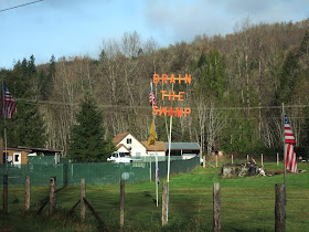
Political Sunday: Tea Leaves up the Skagit

I took advantage of the rare break in the wet weather on Friday and headed out to do some field work up the Skagit. My venture took me past political message enthusiast east of Concrete.
 
 I will be curious how the swamp draining will be perceived over the next couple of years or so. I have a sense that this sentiment may be misinterpreted. I don't think it is entirely directed at perceived corruption, but is also directed at government in general.

This concept is a bit backed up by "LOCK THEM UP" and the classic "don't tread on me" (Gadsen)flag.

Digesting this past presidential election can lead to some erroneous views by broad generalizations. My political experience has been concentrated at a local level - county and city. The views expressed along Highway 20 above are nearly lost in the political leanings of Washington State, but I might be able to project a bit about what these views mean at a local, Skagit County level. At that level they may have some influence, and perhaps even more meaning.

One take-away I have about presidential politics is that it has become very localized. What voters in California, Texas, New York, Alabama and Washington as well as the vast majority of states think almost does not matter. The presidential political struggles both in the general election and in the primaries is focused on small localized slivers of populations in "battle ground" states. Small swings of a small subset in those states drives political positioning. It is a bit maddening that large swaths of the country are rendered politically irrelevant and national interests are driven by small subsets of our nation.    

Wednesday, November 23, 2016

Safe Travels: Lisa Hannigan - Home - Live in Kinsale

I am staying put sort of this Thanksgiving.

But a blog tradition for this time of year is a bit of Lisa Hannigan for those going "home" for the big meal:


And the blog's Thanksgiving travel music traditional song:


Sunday, November 20, 2016

Swiftsure Bank Border Dispute

Our border with Canada has had few problem locations that needed to be figured out (canada-united-state-borders-5-minute) including a major challenge in the San Juan Islands (borderlines-and-oregon-country-Whatcom). Point Roberts may have been overlooked during the initial border draw, but its value as access to salmon runs for Americans precluded any talk of a border adjustment. Issues associated with inaccuracies of the original 49th parallel survey were readily worked out.
 
A new border dispute arose in 1977 when nations began laying claim to coastal waters. Google Earth ends the U.S. - Canada boundary at the mouth of the Strait of Juan de Fuca.  
 

The question beyond the entrance of the strait uses the same principle as within the strait. The line is drawn equidistant between the two shores. Hence, the border in the ocean takes trend line to the southwest beyond the strait. The dispute has to do with where one starts to draw the line from the coast. The Americans used the low water line off the northwest coast. The Canadians used as starting point a line drawn along the Vancouver Island shore from point to point. 

From Gray (1997) (IBRU Boundary and Security Bulletin)

The differences between the two methods creates two small slivers of ocean water in dispute. The northeast sliver may be the more important one in that it includes the Swiftsure Bank. Swiftsure is touted by fishing charter folks on both sides of the border.

Friday, November 18, 2016

Notes on a Close Vote in Whatcom County: EMS Levy

Whatcom County is in the midst of a very close election count. An emergency medical services property tax was on the 2016 ballot. The levy requires a 60% yes vote to pass. Yes, it is close!
 
But note that EMS is out polling Clinton and Trump. The presidential vote in Whatcom County did out poll EMS; I cut off the "third party" candidates - the total of all presidential candidates was a bit more than the total for EMS.

However, a very striking part of this vote is the turnout in Whatcom County was 82.4%. Pretty good compared to the national 55% turn out at the national level. We are not a red state - blue state divided country; but divided as well on a third level with voters and non voters.

The closeness of the EMS levy did get some Seattle-centric attentions: http://komonews/it-couldnt-be-any-closer-local-levy-passing-by-01-percent.

I should note that this is the first EMS property tax levy in Whatcom County. Previous EMS taxes had been sales tax funded combined with local fire district levies and money from the Whatcom County general fund.  

Thursday, November 17, 2016

Samish Island: No Ferry Needed

Due to a cottage and Lisa's studio being on Samish Island, I have (and Lisa) had to explain that one can drive to Samish Island. Samish Island is barely an island.

Road to Samish Island as seen from the island
Alice bay is on the left and swampy fields on the right

The island is connected to the mainland via tidal mash and tidal flats where dikes were built to create farm land during early American settlement. The initial survey map shows a narrow continuous water connection across the area shown in the picture above.


It should be noted that the water covered areas of the map, Samish Bay on the far right, Alice Bay on right and Padilla Bay on the left all become mud flats during low tides. Very high tides would inundate the marsh land if not for the dikes that keep the high tide water out.

In the early days of American settlement, building dikes to farm areas of delta land was a quick way to develop farm land as little tree and brush clearing was needed. The down side is maintaining drainage. The lower areas become difficult to maintain and over time some of these areas have been abandoned as farm land, at least in part due to drainage problems or periodic inundation with sea water.

River flooding into the delta creates a situation where the dikes used to keep the sea water out end up holding the flood waters in and Samish Island becomes an island once again.

1990 flooding of Samish Flats south of Samish Island

Sunday, November 13, 2016

Sail on: Leonard Cohen and Democracy

Sail on, sail on
O mighty ship of state!
To the shores of need
past the reefs of greed
through the squalls of hate


Saturday, November 5, 2016

Wenatchee Formation and Randy Gresens

Wenatchee Formation above Squilchuck Creek

Once upon a time I was pretty familiar with the Wenatchee Formation as well as the Swauk and Chumstick. These rocks are within a structure called the Chiwaukum Graben, a fault bound, dropped downed block. The formations within the graben structure were formerly more wide-spread, but were subsequently eroded as the Cascade Range uplifted; the old graben structure has preserved a section of these formerly more wide spread rocks that may have correlative formations on the west side of the Cascade Range.

My understanding of these rocks had gotten a bit rusty. It had been so long that I had forgotten that I once did some geologic excursions up the Squilchuck Creek valley south of Wenatchee. My memory of that time got a boost when I saw the slope pictured above. I visited this slope with Randy Gresens, a professor of mine, during my in and out of school era. I had just returned to college for the third time when I went on this trip. We took two field trips and one was up the Squilchuck drainage. This slope provided a good introduction to the Wenatchee Formation.

Randy Gresens mapped this area and two quadrangles to the north. http://file.dnr.wa.gov/publications/ger_b75_geol_wenatchee_monitor.pdf.

The maps are highly detailed and the report with the maps provides detailed and very specific site location descriptions. It is a model of how a good quadrangle map should be done. In retrospect, I realized that those field trips were to places that were just beginning to be understood by the mapper. The way I recall the second trip, we did not find what we (Dr. Gresens) were hoping to see - that is I got to experience a theory being tested and that theory being proved wrong, a good lesson for a student.

The map publication took place after Dr. Gresens died in a plane crash. The crash took place above the Squilchuck drainage in the Mission Ridge area. Eric Cheney, another professor, wrote a memorial for his associate:  geosociety.org/pub/Memorials/v14/Gresens-RL.pdf. I did not know Dr. Gresens beyond the two classes I took from him, but he treated me fairly in one class I was ill prepared for (geochemistry) and he expanded my field background with those two trips to the rocks in the Chiwaukum Graben.

Wednesday, November 2, 2016

Lost Coast of Douglas County


Alluvial fan building into Columbia River below Bigelow Springs

Lost Coast is a term applied to a section of the northern California coast where steep terrain and other factors have precluded road building and development. Washington State has numerous areas that the term lost coast could be applied, including areas in Eastern Washington. One of my favorites is the Lost Coast of Douglas County. 

Douglas County is bounded on the north and west by the Columbia River as the river flows through its big bend turning south from its westward flow when it erodes into the eastern slopes of the Cascade Mountains. The river along this stretch is incised into a deep steep valley. The Lost Coast of Douglas County can be viewed from the Chelan County side of the river. 

The Douglas County side of the river is rugged rocky terrain with steep slopes rising up 2,000 feet to the Waterville Plateau.    


Alluvial fan at the mouth of Hendricks Draw

This area of the Columbia River valley has been glaciated. The Okanogan Ice Lobe covered the northern part of the Waterville Plateau and also extended down the Columbia River valley. This ice lob blocked the river forming a large lake up the river to the east.

Cliffs and rocky terrain of rising above the Columbia River

I bit further north glacial terraces and moraines and huge glacial erractics scatted across the landscape.

The Douglas County lost coast is not entirely undeveloped and roadless. A few jeep trails and dirt roads partially penetrate the area. The land ownership consists of a couple of very large ranch holdings, some BLM land, Washington State Trust Land managed by the DNR, and some areas of Washington State Fish and Wildlife land. The southern part, on the upper slopes, has been partially divided into rural home lots with some improved roads, but is far from being built out. It should be noted that the area is very susceptible to wildfire.