Saturday, April 30, 2016

Landslide Field Trip (non Washington)

Earlier this spring I visited a slope area with extensive areas of slopes undergoing slow failures that seemed to be a mix of relatively rapid soil creep and in places earth flow landslides. Large tracts of land where just about everything was moving in some manner.
 

The movements presented road challenges.


The more advanced areas had morphed into badland topography.
 

Friday, April 22, 2016

A Take on CO2 Tax

Paul Krugman (Paul Krugman 101-boosterism) gave a bit of a preview of a carbon tax write up by Dave Roberts (Putting a price on carbon is fine. It is not the end-all be-all). Roberts is a Seattle based writer and writes on energy policy for Vox along with Brad Plumber. Very informative and thoughtful assessments of energy policy, markets and politics that I routinely read. The Price on CO2 piece is the first of two articles by Roberts on CO2 taxing.
Washington State will have a CO2 tax proposal on the ballot this fall - so a chance for Washington voters to decide if this is a good idea, but also to recognize it is at Roberts notes not the be-all end-all. And keep in mind that after passage (if that does happen) there will be plenty of likely future modifications that can be done to improve or harm the tax plan in the future.   

Tuesday, April 19, 2016

Forest Patterns: Dice

A while back I noted a forest harvest checker pattern in northeast Washington (landscape-checkers-in-washington-state). That post got linked to by a site called craked.com and they called the image gods-chess-board.

While scanning through Google earth for researching purposes I stumbled across what one might call God's Dice.


With chess patterns and dice patterns, maybe some clever forester will lay out a backgammon harvest.

The area shown above is within the Capital Forest, a large block of State Trust land managed by the Department of Natural Resources. I am not fully up on the habitat that these circles are supporting or enhancing. The circles or inverted circles for the case of the "3" above are a means of providing a mix of age stands. At some future date there will be stands of open mature timber for spotted owl, marbled murlet or other mature tree canopy dependent species. 

Monday, April 18, 2016

Landslide Generated Waves: One Big Example

Trees stripped off landscape by landslide generated wave
Picture via Chris Larsen and University of Alaska Fairbanks

The University of Fairbanks has a nice write up of the massive landslide generated wave that swept through Icy Bay (http://www.gi.alaska.edu/alaska-science-forum/giant-wave-icy-bay).

Given the size of the landslide and the confines of the upper part of the bay, a big wave would be expected. The landslide was really big and early estimates are 200 million tons of rock slid in the event. If so, this puts the slide in an elite level; the UAF site suggests this might be the largest non volcanic landslide by volume in North America's written history. I like the caveat about written history as there is an excellent oral history on a not-so-old, but much larger slide.

The slide and wave generated is a reminder that landslide generated waves are a potential risk around steep slopes and water bodies. A slide off the south end of Camano Island caused a wave that led to fatalities on the nearby Hat Island to the south. This event is another oral history event and has since been verified as being relatively recent.

During recent volunteer work, I drafted some geologic hazard code language for the potential for a landslide generated wave hazard. I felt it appropriate to have specific language for landslide generated waves versus tsunami hazards or seiche hazards as the locations are different and the potential return intervals are different. The risk from tsunami, seiche waves and landslide generated waves will be unique for each county and city so simple code copying is a bad idea.

The landslide generated wave hazard is clearly no small thing in some of the very mountainous inlets of Alaska. The land shown in the image above would not be a good town site.    

Thursday, April 14, 2016

Notes on the Giant Columbia Valley Erratic


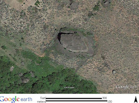
The Okotoks Erratic in Alberta is touted as the largest glacial erratic (https://nsidc.org/cryosphere/glaciers/gallery/erratics.html). I observed a very large glacial erratic in the Columbia River Valley a bit below Grand Coulee Dam. Below is an approximate comparison of the two erratics via Google earth. 

Okotok

Basalt erratic west of Grand Coulee Dam

Based on the imagery, the Washington State erratic is bigger than the Alberta one. This erratic in the Columbia Valley is sitting in glacial lake sediments and the valley bedrock in the vicinity is granitic. I had noted these erratics previously (glacial-erratics-near-grand-coulee-dam), but had not recognized this particular one at the time.

As long as megablocks and rafts are excluded, the above Washington State erratic may be considered a competitor for largest erratic designation.

Glacial transported megablocks and rafts are huge sheets of material that get frozen to the base of glaciers and transported could well be considered much larger erratics (HERE). Megablocks  Stalker (1973) and  Stalker (1976) mapped huge sheets of rock that were transported by glacial ice in Alberta that are square kilometers in area. Stalker (1973) stated "The writer would recommend that the term "erratic" not be used, at present, for this type of bedrock mass".

A possible explanation for the huge erratics near Grand Coulee dam may be that they were part of a megablock that was adhered to the base of the ice but readily broke apart as the ice extended out over the blocked Columbia River forming Glacial Lake Columbia. Perhaps basalt flows would be susceptible to this mechanism - but this is getting ahead of my understanding of megablocks and rafts.    

Thursday, April 7, 2016

Mud Rotary Day

My drilling oversite days have been limited over the past few years. I would say I am even a bit rusty at the job in that my skills of of opening sample tubes and putting them back together and using some of the tools was a bit awkward.

The project was to collect geotechnical data including assessing the the potential for soil liquefaction during a seismic event. Having done a bot of historic research as well as what I knew of the geology combined with the data needs, I went with a mud rotary drilling approach. 

The set up starts by digging a shallow pit and punching a hole through a bag of bentonite clay chips. Na-bentonite expands when wet and hence is an excellent sealant.   


The mud tub is placed over the hole in this case.


Clay is added and mixed with water to form the drilling mud. If this was a deeper boring (our scheme was to drill to 50 feet), a lot more mud would be needed. Drilling mud keeps oil and gas field drilling crews busy.


The actual drill is a tri-cone bit. We started with a used one as at least initially we had pretty easy drilling. Hard drilling some times carries a higher per foot charge as the ware on the expensive brill bits is a cost to the drillers.


The drill bit is attached to drilling rods and drilling begins with the mud circulated through the drill and back up into the tub. The mud spills onto a screen which captures bits of rock which are scraped off into a bucket by the driller helper with the rest of the mud being recycled into the system.


One can get an idea of the material encountered by inspecting the screen or grabbing some of the cuttings in the mud. In the picture below it was clear we were drilling through some wood.


Typically every five feet the drill is pulled up out of the hole and a sampler is attached to the drill rods. The sampler is then lowered to the bottom of the hole and driven by a hammer on the top of the rods into the subsurface ahead of where the drill had been. The mud keeps the hole open and in this case needs to also be thick enough to not leak out into the formation. Sometimes that is not possible if the formation is very coarse grained. In that event casing needs to be driven. In our case we were lucky and did not need to case the well - a time consuming process to be done right and not get the casings stuck.

The advantage of the mud approach is it prevents the sand we were drilling into from surging into the hole when the drill is pulled out for sampling. A big deal when one needs to get accurate in-place undisturbed soil compactness. The compactness can be estimated by counting how many hammer blows it takes to drive the sampler into the soil. If the soil is soft, the blow counts will be low, if compact the blow counts will be high. getting accurate blow counts is a big deal for assessing potential soil liquefaction.  

After the sampler is pulled up, it is handed to the drilling logger (very often a geologist) and opened up and inspected on site and then collected for further assessment back in the office/lab.


In our case we were drilling into some very old beach deposits with periodic clam shells. This shell came from a depth of 30 feet - nearly 20 feet below the current beach level.


At about 40 feet the drilling encountered hard compact silt with pebbles (see below). We also drilled through a 4-foot diameter granite boulder. I interpreted the hard silt with pebbles and boulders as being an older glacial drift based on stratigraphy of the area.
 

Wednesday, April 6, 2016

White Nose Syndrome Reaches Washington

Washington State Fish and Wildlife reports the first case of a white-nose syndrome infected bat in Washington State  wdfw.wa.gov/news/. This disease has decimated bat populations elsewhere in the U.S. The impact to insect populations could become a consequential side effect.

Tuesday, April 5, 2016

Laments of City Changes

Timothy Eagan writes about Seattle and how it has been changing (dude-wheres-my-city?). Mostly Eagan notes that Seattle has become a very expensive place to live. So much so that it is having a profound impact on the character of the city. Eagan uses the Seinfeld show character Kramer as an example as the type of person that may be pushed out of Seattle. However, it should noted that Kramer lived in an apartment in Upper West Side of Manhattan. Perhaps rent control was the key to keeping Kramer in Manhattan -  a route Seattle has not taken.

Eagan asks "How do you contain the excesses of entrepreneurial capitalism and nurture the things you like - original music, food, businesses and literature, affordable homes for cops and Kramers?" Eagan does not attempt to provide answers. The answers are complex and often lost in the slow hard grind of urban and community planning - zoning, development regulations, property tax structure, transportation plans, sewer and water and other utilities, long public meetings and hearings and local politics. Having been in my share of local planning efforts as a citizen, consultant and as a local politician it is hard complicated work. There are also factors well beyond the control of the cities themselves. Outside economic forces, political forces, climate shifts and geology.

Cities are dynamic places. As Eagan notes, the west coast cities including Seattle are going through rapid change. Most of that change is associated with rapid growth and tens of thousands of new jobs. That growth presents challenges that are very hard. But then there are cities that have had the opposite issue - negative growth such as Detroit being one example.

I know the Seattle I once knew so well is in may ways very different than what it has become. Parts of my own current town, Bellingham, have changed in ways that could be lamented in some cases and celebrated in others. Oddly my own neighborhood has remained nearly the same over the past 100 years.

Perhaps it is part of aging that we lament the past. From my tribal homeland Luke Kelly and the Dubliners lament Dublin's past:      


Neko Case sings a hopeful song abut Tacoma remaining the same (it might be suggested that Tacoma has improved a bit of late):


Luke Kelly also sings of Derry in the The Town I Loved So Well, in this case a truly lamentable situation when the song was written:

Sunday, April 3, 2016

John Mix Stanley at the Tacoma Art Museum

The Tacoma Art Museum has an exhibit of painting by John Mix Stanley: http://www.tacomaartmuseum.org/exhibit/painted-journeys-art-john-mix-stanley/details/

The exhibit started on January 30 and runs to May 1. His collection of over 150 western paintings was housed at the Smithsonian in Washington DC from 1852 through 1865. Alas that collection was nearly completely destroyed by fire. The exhibit in Tacoma has been previously in Cody and Tulsa. This is a rare chance to see a compilation of his works.

 John Mix Stanley is my favorite 19th century painter of the U.S. west. I posted about him previously (john-mix-stanley-in-oregon-country). He was considered the best western painter of his day, particularly his paintings of western Indians. He also produced drawings of scenes of the Pacific Northwest along the potential routes of the future railroads as he was part of the survey explorations. His work had a profound influence on Washington DC policy makers regarding the Pacific Northwest, the West and western American Indians in that it provided accurate visualization of a landscape and people far removed from most Americans at the time. 

Friday, April 1, 2016

Trees, Views and Slopes

Western Washington is a land of trees. Trees that grow tall fairly fast. As such trees may impact views. Trees can also play a big role in slope stability. Slopes stable in a forest condition can become unstable as more water reaches the soil or roots that provide soil cohesion (root cohesion) die. Trees also provide a natural backdrop that is highly valued. They also provide habitat.

Tall fast growing trees can also create conflict.

seattletimes.com, westseattleblog and  (crosscut) all cover a story of tree removal from a slope in West Seattle. In this case, trees on Seattle Public Parks land were cut without permission in order to maintain or create a view from some homes to the Seattle downtown skyline.

Based on the images, most of the tress cut were big leaf maple. The images also suggest that at least a portion of the tree cutting was at sites where the maples had been previously cut.

2007 (King County)
Blue line outlines approximate area where cutting took place
derived from articles, but may be less area was cut

2007

The 2007 images suggest that tree removal was a well established practice on part of the slope to the east. The 2007 images also indicate tree cutting was beginning to expand to the northeast of the homes at that time. Note there appears to have been trees removed between the two 2007 images.

2009


1936 aerial (King County)

There were a lot less trees on the slope in 1939.

Many of the steep slopes in the city have a long history of being unstable and hence the large swaths of hillsides within the urban areas of thick forest. Unbuildable, or at least expensive to build, land is a characteristic of may areas of Seattle. Much of this land has be over time acquired as park land.

The LiDAR imagery of the slope indicates likely large landslide scars in the vicinity of the site as well as secondary slide and erosion features.

LiDAR (King County)

Obviously unpermitted tree removal from a public park is a potential trouble for the parties involved. These hill slope areas will get more attention as trails are built and the value of urban open spaces with habitat become more valued by the public.

The value of trees on this particular slope from a slope stability perspective is not entirely clear without further assessment. Overall, the LiDAR suggests some deeper failure mechanism. It should also be noted that this slope is relatively close to the Seattle Fault zone.

Based on the articles and the policy issues and now public/political scrutiny, this view enhancement project will be rather expensive.