Saturday, February 28, 2015

Remembering "Live long and prosper"

Leonard Nimoy was more than Spock. He was a talented actor, director and photographer. However, his development of the character Spock figured large in his life's work and is why so many wonky/science minded folks have written some outstanding articles about Nimoy the past two days: 
Matthew YglesiasDylan Matthews, and Lockwood to name a few.

I am not sure I know how much his portrayal of Spock inspired me, but I do know that it was for the better. While Nimoy was not Spock, I appreciated that what Nimoy did with Spock - he was a powerful lasting character that dealt with the logic of morality and came across as passionate without emotion. A great role model for a science officer and for humankind.


Friday, February 27, 2015

Notes on Coal Dust and Bakken Oil

Cliff Mass put up a post of a study he and a student completed regarding wind and potential coal dust at the proposed Cherry Point coal terminal strong-winds-coal-dust. Dr. Mass points out a variety of issues with this proposed project that I am sure is a delight to coal terminal proponents.

There is a picture of flying coal dust from a wind event that hit the coal terminal just to the north in Canada. Lest anyone suggest coal dust does not get blown off of coal piles, here is the Boardman, Oregon coal power plant:
Coal power plant in Oregon

While coal trains passing through Washington State got lots of early attention, the more recent large increase of oil trains all over the country has raised concerns regarding safety. With several refineries in northwest Washington, Washington State has seen a large increase in oil train traffic.

Oil train in Skagit County

The Bakken oil has proven to be a desirable oil for northwest refineries in Washington, and these refineries have shipping facilities that allow for transfer of the oil to ships as well. The Bakken oil contains a lot of volatile components relative to other oils. Part of the problem with the Bakken area is the lack of infrastructure. That lack of infrastructure includes impacts to communities in western North Dakota, but also means there is a large lag of facilities for handling the oil. Pipeline capacity is minimal and local field processing that takes place at more mature oil fields is not present. There is a lack a pipelines so that secondary natural gas is flared wasting-gas-for-short-term-gain and energy-notes-drill-and-burn-wasting-gas. Another impact of the rapid development of this field is that volatile butane and propane are not removed from the oil prior to shipping. More mature fields will separate these components out as they are easily removed and are valuable. A side benefit that is starting to become apparent is safety. Without the volatiles removed, the oil is much more likely to ignite and burn.

The scale of change in the Bakken has been remarkable. I noted that change when I was in western North Dakota a few years ago oil-boom-in-western-north-dakota

Red circles mark post 2005 wells. Prior to that time there were only two oil wells in this small section of the Bakken

Two pre-2000 well sites


Well sites have expanded to include service facilities to other well sites and the farm across road has added a camp area for workers

Wednesday, February 25, 2015

Non Washington Post: Blackhawk Landslide

Heading home bound I recognized this landscape that is familiar to many geologists:

Blackhawk Landslide, Lucerne Valley, CA (Photo - Lisa McShane)

Shreve (1959, http://thesis.library.caltech.edu/691/1/Shreve_rl_1959.pdf and 1968, http://specialpapers.gsapubs.org/content/108/1.short) suggested the slide mechanics that caused the slide of rocks to travel so far was that it was conveyed on a layer of trapped and compressed air. The slide took place 17,000 years ago and Shreve noted that there were other older, similar slides of similar nature that took place in the same area.

Tuesday, February 24, 2015

Non Washington Post: Unconformity in the Mecca Hills

I took a trip to visit friends and they joined me on a little geology adventure to the Mecca Hills. The Mecca Hills are a low range of hills on the southern end of the San Andreas Fault zone. The southwest side of the hills has the main trace of the fault and a second fault is located along the northeast side of the hills. The landscape along and between these fault strands is spectacularly contorted. Sylvester and Smith (1987) describe the unique structures that evolved along the faults. The canyons cutting through the hills are a structural delight and a stopping place for many new geologists to map strike and dips and folds and get a three dimensional sense of rock units.  
 
One feature that is tucked up in Painted Canyon is that basement rocks have been uplifted and the unconformity contact is extremely well exposed.   


The older basement rocks themselves tell a very complicated story that is variously interpreted and requires a broader context to even begin to appreciate. The short story is that these rocks were thrust under the North American margin, were penetrated by magma, and later unroofed. See Jacobson and others (2007) for a more detailed introduction and an appreciation of working out very complex tectonics. The exposures of these rocks along the canyon walls of upper Painted Canyon provide an opportunity to see a deep crustal section. 


Getting to these features is a fun adventure and has been greatly improved since I once frequented these canyons (we lived near here during another era).

The Mecca Hills are accessed via Painted Canyon - county park and along Box Canyon, a paved road that connects from the Highway 111 and Interstate 10. The upper Painted Canyon and most of the hills are BLM managed Wilderness. A volunteer group maintains the ladders that get one past the various cliffs and drop offs in the canyons.

Sunday, February 22, 2015

Alluvial Fan Code/Regulations


I have been doing some code/regulation language work in regards to geology hazards. Alluvial fan hazards have presented a challenge.

Alluvial Fan Hazard Areas: Alluvial fan hazard areas shall include those areas on alluvial fans potentially impacted by debris flows, debris floods, clear water floods, stream channel changes, and erosion. Watershed hydrology, geology, slope conditions, topography, land use, valley bottom and channel conditions upstream of an alluvial fan area are fundamental to potential hazards on alluvial fans.

It is one thing to recognize the hazard, but then What is the risk and What are the consequences? And every fan is a bit different and sometimes a lot different. I find writing code/regulations for alluvial fans ought not to be done without a very careful review of policy. Because like alluvial fans, every community is different.


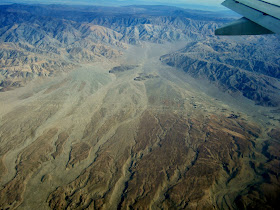
I should add that one of the added hazards western Washington has on alluvial fans is the large wood entrained in debris flows and floods relative to the desert fans shown above.

Wednesday, February 18, 2015

Yard Waste and Steep Slopes

A frequent recommendation I make in geology hazard reports for steep bluff slopes is not to place yard waste on the steep slope. The yard waste will eventually build up mass as more material is added, kills the plants and roots under the waste, and when wet will slide down the slope. Hence the frequency of slope failures increases. It is a common practice and I suspect that there is either a mistaken belief that the yard waste will improve the slope (make it bigger?) or steep slopes are viewed as wasted land suitable for garbage disposal.
 
I had a field day a couple weeks ago where I encountered slides initiated by yard waste and some other generally poor slope management at multiple sites. 
 
Slide of yard waste pile including the Christmas tree

Tree cutting for the view but with all the material left.
This will kill much of the under brush.
Also is terrible to traverse as a geologist trying to assess the slope.

Another yard waste failure.
This one had covered the train tracks.

Tuesday, February 17, 2015

Southeast Decatur Island Notes

I took a trip out to Decatur Island. The trip was non work related, but it did allow me to revisit a section of shoreline bluff I had observed 5 years ago (whidbey-formation) to see how the landslides and erosion I had observed then were progressing.

The landslides are on the southeast coast of Decatur and show up as divots along the southeast coast in the LiDAR view of the island.

Slide areas outlined in red

Besides the landslides, the clear weather provided a nice view of Mount Baker and the remarkable lack of snow on the lower peaks fronting Baker.

There are a variety of glacial and non glacial units along this reach of shore called White Cliffs for the light colored tone of the units.

Glacial drift is present with fine silts and an occasional drop stone.
LiDAR and elevation and lack of very hard compaction leads me to believe these units are marine drift - that is the sediment was deposited on the sea floor from glacial ice floating on the sea surface.

A dominant unit is a finely layered silt which readily parts, but is otherwise rather hard. The ready ability to separate along the former bedding layers plays a significant role in the stability of these slopes.


Another player in the deep-seated landslides is the presence of peaty layers which in places were protruding through the surface of the beach suggesting that they may have been back rotated within a deep-seated landslide that extends below the tidelands. the peat also suggests that the units in this area are pre-glacial and the observation of an older glacial drift below the drift on the upper bluffs suggests that these pre-glacial sediments may be from the Whidbey inter glacial period 100,000 years plus in age.

However, the geology units at this site are not nicely layered cake. Some of the silts are highly deformed. Whetten (1975) described and photographed this exact same location shown below as an example of ice thrusting deformation and the site has not changed very appreciably since in comparing pictures.


One last geology observation was a cluster of rocks within younger glacial recessional deposits that I suspect may be from a buried block of ice that melted out leaving behind the cluster of cobbles. An alternative explanation could be that it was simply a narrow more energetic stream channel or somebody was dumping rocks from the bluff above.


The large landslide areas associated with the deep-seated landslides did not appear to have expanded since my last visit, but there was definite recent slope movement within the landslides as secondary failures have taken place within the layered silt zones as the material falls apart and the sand and gravesl overlying the units go along for the ride down the slopes.


Outside the area of large slides, classic shoreline erosion and under cutting of the bluff is taking place with a very recent bluff collapse that showed almost no erosion yet.

Sunday, February 15, 2015

Bald Mountain - A Metamorphic Knocker Near Lake Cavanaugh

I had a nice view of Bald Mountain in the western part of the Cascades of Skagit County.

The summit looks like a bit like Devils Tower in Wyoming - a big block of rock protruding above the landscape.

The bedrock is volcanic in origin, but this is not the plumbing of an ancient volcano; it is a block of metamorphosed basalt that is surrounded by much weaker metamorphic rocks that have been eroded away. Dave Tucker has a nice write up (fieldtrips/the-high-dome-of-bald-mountain-and-big-rock-too) with references so there is no need for me to repeat. He notes that blocks of resistant rocks sticking up out of softer metamorphic rocks are referred to as "knockers".

The LiDAR of the area shows the Bald Mountain has been partially eroded out by glacial ice having over ridden the area.   

The ice direction movement can be seen by the striations marked in blue. Ice from the Puget ice lobe flowed up into the Cascade Range at this location. This ice lobe blocked the Stilliguamish River causing the formation of a lake in the Stilly valley. Sediments associated with that lake were involved in the Hazel/Oso landslide. Note too in the LiDAR the two landslides that have scarred the glacial striated slope post ice age.  

Friday, February 13, 2015

The Levee Hook at Deming

I've posted before about the Deming levee (nooksack-levee-at-deming). The image below shows what is being protected and points out the hook at the downstream, west end of the levee.
 

The hook at the west, downstream end is taking the brunt of the river of late and has been progressively eroded. The only purpose of the hook is to prevent the river from entering into an area of bottom land with forest and old river channels. The hook was built by the Army Corps of Engineers after a flood event a few years ago and the local diking district would like this section of levee to extend down river to another set of levees.

The forest land behind the hook is all low flood prone land with former river channels so permitting and justifying the costs of a levee along this river reach would likely be problematic as it would narrow the flood plain, cut off habitat areas, and be very expensive way to protect private land. The land is private so it is understandable that the owner would like to see a levee and a hard pill when watching your timber get eroded away. But then again it is a hard pill to have tax payers pay for a massive levee project to protect private land. A geologic argument could be made that the hook is causing property damage on the other side of the river as it is deflecting the river towards the opposite bank. Eventually I suspect this reach of river will be purchased and turned into a habitat project perhaps as off set for the confinement and habitat loss of the river elsewhere. 

What can be said is that the levee upstream where it was designed to protect Deming, the school and the Nooksack facilities including sewer systems for both has held up well despite some hard testing of the river aimed directly at the structure in 2007.


The hook is marked on the DEM below:

A careful look shows how the hook is blocking and directing the river away from the old channel area downstream behind the hook.

Wednesday, February 11, 2015

Notes from Grandy Creek, Skagit County

I was up the Skagit River valley and then up Grandy Creek Road to assess a slope. Grandy Creek Road is the access route to Baker Lake a hydro electric reservoir east of Mount Bake on the Baker River, a major tributary of the Skagit.  
 
I put my foot up on this cut bank slope for scale.
The sand and gravel is poorly sorted glacial outwash
The unit was compacted suggesting that it had been overridden by glacial ice

On the way back from my work ventures I stopped by Grandy Lake. A Skagit County Park is located along the shores of the lake.

The lake adjacent to the shore clearly has some history as indicated by the pilings 

The pilings supported buildings and an old power pole suggests indicates the old site had electric power. I am not clear on the history of the lake and valley, but suspect the lake was used as a log pond and the pilings supported a mill. Settlement had penetrated this area by the early 1900s and included power plants and extensive trails and rail lines are indicated to have been extended part way up Grandy Creek in 1915 and I suspect rail came further up as logging spurs of short duration. Further up the valley a swampy was converted to a log pond and in the 1960s was dredged and dammed to create a recreational center, Lake Tyee.  
 
The local geology is a bit complex. Jon Rediel (2007) has made a good go at working out the mix of continental and alpine glaciation that has impacted this area. he proposed a large set glaciers coming off of Mount Baker and the other high peaks to the north blocked the Skagit Valley prior to the arrival of the Continental ice. The compact units I observed above combined with LiDAR suggests that the unit was overridden by Ice from the north and continental ice.
 
The valley Grandy Lake is located is a bit over sized valley for the stream now occupying the valley. A late glacial age former water route carved into the terraces on the north side of the Skagit Valley as water from up the valley drained to the west around and possibly under that blocked the valley.    


On the lower end of Grandy Creek I took in the view of a high cut bank above the creek. The creek has cut through the glacial-age terrace providing a nice cross sectional view. The units grade coarser up section suggesting this set of sediments is a prograding deposit as an ice lobe from the Puget Lobe advanced up the valley.


Massive sand and silty sand overlain by very poorly sorted gravel and cobbles to boulders.

Silts at the base of the slope consistent with lake sediments in a lake that would have formed from the lower Skagit being blocked by ice to the west.

I wrapped up the afternoon by indulging in my support of the local rural economy at the Grandy Creek Grocery.


Monday, February 9, 2015

Geology: Civilization Take Notice


I always liked this quote regarding civilization by Will Durant and have used the quote in various presentations. Durant rightfully recognized the history of civilization is full of destruction of civilizations by geologic events both fast and slow. I like that geology was recognized by Durant as an integral force in shaping civilization.

As much as I like the quote, I have been rethinking it a bit. I still think it is a very useful quote in regards to geology hazards, but am of the view that "subject to change without notice" part of the quote should be rethought. We can read the notice. Geology tells us what to expect - perhaps not always on a predictable time frame, but we are provided notice. We can recognize volcanic hazards, earthquake hazards, flood hazards and landslide hazards. What we do with that notification is the question now.

Saturday, February 7, 2015

Science and Reasonable People

Because vaccine data is reported in Washington schools, this is a great opportunity to assess attitudes across Washington State with overlaps of demographics and political views. This from the Seattle Times provides a easy way to see the vaccination rates across the state:
http://blogs.seattletimes.com/fyi-guy/2015/02/04/explore-this-vaccine-exemption-rates-for-every-washington-school/

Science/policy/communication and how people decide is a subject I have no real expertise. My lack of expertise has improved over time from experience both good and bad. On some matters I am still perplexed. Hence, the vaccine issue is of great interest in trying to glean some lessons.

Joel Achenbach at National Geographic provides a nice overview of the topic of science and policy ranging across a variety of science/public policy matters Why Do Many Reasonable People Doubt Science? Some good thought provoking stuff and some resources I am familiar with. What I like is the emphasis on the idea that people are reasonable. Their reasons and rationale for rejecting science are --- well often reasonable. But the reasonableness has very little to do with science, but is instead motivated by social and tribal politics and philosophy or simply good old greed. It does not mean they are right. And being wrong has consequences.

I found this interview of Eula Biss to be very informative vox.com/how-one-vaccine-skeptic-became-a-vaccine-supporter.

It might be best to start with the assumption that most people are reasonable. It does not mean they are right. And I still get a sense that debunking, shame, and pointing out facts will still have their place.


Friday, February 6, 2015

Atmospheric River Opportunity

Our weather is in atmospheric river mode. The term describes the fact that there is the equivalent of a huge river system in the air coming out of the sub tropics to tropics and dumping itself on the west coast. These events are a big deal geologically and play a major role in shaping the land.

It is also a big deal for California. This is the visible satellite image from earlier today. Northern California will get some water in their reservoirs. Good news for almonds.  


The infrared shows the moisture tap is from south of Hawaii. And there will be additional streams of atmospheric rivers from the same regions over the next couple of days.


This particular set of atmospheric river storms is getting some extra scrutiny http://www.esrl.noaa.gov/psd/calwater/. The intensive investigation which was setup for this year should be getting a bonanza of data over the next couple of days.

Although rain will impact a large area from these storms, these storms have a tendency to have a relatively narrow band of very intense rainfall. In 2007 when of these narrow bands of precipitation locked into one location and triggered hundreds of landslides and wide spread flooding in southwest Washington and northeast Oregon. There were some other factors that made that storm so destructive, but the bulk of the trouble was from the huge precipitation band.

The NOAA CalWater study hopes to gather information that will give climate and weather folks a better handle on these types of storms.

There has been a fair bit of study of these storms and how they might behave in the future with some recent studies indicating that the events may increase in frequency and magnitude in the Pacific Northwest (Warner, Mass and Salathe, 2014) http://journals.ametsoc.org/doi/abs/10.1175/JHM-D-14-0080.1.  These results are consistent with other other studies in the Atlantic Ocean.