Saturday, December 31, 2011

Energy Notes

The United States Energy Information Administration puts out various energy reports with great graphics http://www.eia.gov/. Having spent a little time this past year on the high plains I was impressed with the intensity of the Bakken Shale Oil Boom oil-boom-in-western-north-dakota. This graphic shows how rapidly that oil play has developed.


I had also editorialized a bit on gas flaring from Bakken wells wasting-gas-for-short-term-gain. The EIA put out an interesting graphics on gas flaring as well. Note that the first graph shows that gas production exceeds the gas marketed. While the United States does not have a policy that would discourage flaring per se, North Dakota can charge a tax on all gas generated at a well regardless of whether it is marketed or not. North Dakota allows a one year period for flaring and can grant an extension beyond a year for hardship. I do not know much about the details on how this has been implemented, but for gassy wells an incentive to hold back production until infrastructure is in place.


The second graph shows that once the Bakken began rapid development North Dakota's overall non marketed gas peaked at 40% dipped as new pipelines were installed but has begun to lag again going over 35% last year.

The EIA also routinely puts out charts on coal - a subject that has once again become dear to Bellinghamhamsters. (I say once again as Bellingham was once an active coal mining town). As can be seen on the graph exports of coal from Australia, Indonesia and Russia have all increased very significantly over the past decade. Some folks in the United States would like to get in on that coal export action. But as noted in a previous post coal-terminals-in-washington-state the shipping terminal options are limited.


Last a graphic showing a huge energy advantage the the Pacific Northwest has. Greater than 61% of the electric capacity is hydro. The overall hydroelectric generation in the United States is 6%. The result is we have a rather skewered view of energy production. And more recently Washington has added significant wind energy electric generating capacity. Of course our challenge with such a heavy renewable energy portfolio is manging the variableness of that generation.


Friday, December 30, 2011

Follow Up on Permit Extensions

This is a bit of a follow up on my previous post regarding permit extensions david-versus-whatcom-county. As noted in that post David challenged Whatcom County's permit extension ordinance to the Growth Management Hearings Board. The board ruled the ordinance invalid primarily based on the lack of environmental review. Whatcom County did not review of the proposal under the State Environmental Policy Act (SEPA).

County and City ordinances are presumed to be valid under the Growth Management Act. The only way to get a determination that an ordinance is not valid under the act is to prove that it is not valid to  the Growth Management Hearsing Board. A challenging task.

Think about it and one realizes that there may very well be significant numbers of zoning and development regulations all over the state that are presumed valid but may very well be far from meeting the intent of the Growth Management Act. The only zoning and development regulations found to be invalid are those that are successfully challenged before the Board. The ordinance has to be challenged in a timely manner; one can not decide two years after an ordinance passed to bring a challenge to the Board. And the ordinance can only be challenged by those on the record as having raised objections to the County or City.

All this means having to stay on top of the nuances of just what the zoning and or development regulations mean and how they line up with a wide range of goals in the Growth Management Act. Growth planning gets very wonky and complex and is not easily translated to political sound bites.

An interesting issue regarding the Whatcom County case of permit extensions crossed my mind. Whatcom County was by no means the only local government that passed a permit extension ordinance without an environmental review (SEPA review). The City of Bellingham did the exact same thing and even called out within the ordinance itself that the ordinance was exempt from SEPA. I heard vaguely that a number of communities did the exact same thing around the state. So while Whatcom County's permit extension ordinance was deemed invalid, the City of Bellingham's ordinance still stands as does any other county or city that did the same.

To be fair, Bellingham and other local government permit extension ordinances may not be comparable to the impacts of Whatcom County's permit extension ordinance. Geographic area alone makes a big difference. In addition, nuances within past Whatcom county permit vesting dates and old regulations were such that there were clearly a number of subdivisions that would get extensions that would allow development under old very different regulations. For example dozens of lots in the Lake Whatcom watershed that would see no restrictions on impervious areas for minimizing stormwater impacts even though impervious area rules have been in place since 1999.

Some, but not all of the impacts, of Whatcom County's permit extension ordinance were brought before the Growth Management Hearings Board during the appeal. But for other local governments that did not do SEPA on permit extension ordinances, it is hard to know what the environmental impact was as there was no SEPA review.      

Thursday, December 29, 2011

White Fields Without the Snow

It appears that it is likely that we will go past December before we get snow in the low lands of western Washington this year. A bit different than last winter when we had significant snow fall a week before Thanksgiving. But there is still plenty of white stuff on the flat lands of Skagit County - snow geese and trumpeter swans. Initially there were a few snow geese and then a few swans on the Skagit Flats. Now the numbers are impressive. Big flocks brightening the fields with their white feathers. Skagit County is a great place to see them as they are often visible along Interstate 5, Highway 20 and the Highway 10. You can also see them in Whatcom County, but not along the heavily traveled roads like in Skagit.

They show up late in the fall to winter over before heading back to the Arctic. Always a thrill to see that they have made it back for a winter visit. Dave Wenning over at Fidalgo Wild has some nice write ups and pictures.

wildfidalgo.birds-of-feather and wildfidalgo.lesser-snow-goose and wildfidalgo.trumpeter-swan

Tuesday, December 27, 2011

Geologic Pilgrimage: Mima Mounds

Mima Mounds

Early this fall I took a side trip pilgrimage to the Mima Mounds. Amazingly and to some extent embarrassing that I had never gone before. It really does not take that much time to leave I-5 south of Olympia and check the mounds out. For geologists the mounds are great fun because there have been no end of ideas on how the mounds formed. A perplexing problem that I will not hazard adding to at this time. It is my understanding that David Tucker will be including a chapter in his much anticipated field trip guide book nwgeology/my-book. He even has a great picture of a mound in cross section from the gravel quarry adjacent to the mounds, but alas not written it up on his blog. Washburn (1988) provides an over view of the mounds and an evaluation of the reasonable theories. I am not sharing my preferred theory, but I will say that I am in agreement with Washburn that there is no grand mound theory for all the various mound sites scattered around the country. 

While the Mima Mounds themselves are of great curiosity to geologists, there is another geologic aspect to this site. The Mima Mounds are located in Mima Prairie. Yep, we have grass land prairies in western Washington. The geology aspect of the Mima Prairie and some of the other prairies in western Washington is the very gravely glacial outwash underlying the site. So despite a wet climate, this area is exceedingly well drained and the substrate does not hold water. There are other factors as well that causes one to wonder about the anthropocene and the role of humans in regards to ecosystems.


The open prairie grass land ecosystem found at the Mima Mounds has become greatly diminished over the past 200 years. The Mima Mounds are a Natural Area Preserve managed by the Washington State Department of Natural Resources. The mounds themselves are worthy of protection, but the open grass land ecosystem has become an endangered ecosystem with a variety of rare plants and animals found only in these prairie areas. There are other mound sites nearby the Mima Mounds, but the ecosystem is in a better condition at Mima Prairie.

Saturday, December 24, 2011

Traditions, Culture and the Land

Christmas Eve. A time of traditions. A time when cultural layers may dictate traditions. And the landscape influences the culture and the traditions. My family - siblings and our own children all have a variety of traditions and plenty of ideas about what the traditions should be! Many of those traditions are dictated by family ancestry, but the landscape also has an influence as well as the people that live on that landscape.

Living in Bellingham, in the heart of what many people consider the Pacific Northwest has influenced my family traditions. One tradition that we had for many years was the annual Christmas Tree hunt. This involves going out into the rural landscape seeking tree farms. We had calculated this was easier than going all out and getting a Forest Service permit and likely cheaper with higher probability of getting an appropriately shaped and sized tree. This was not a tradition that either Lisa or I brought from our childhoods. Both of us had grown up in eastern Washington. No tree farms there and evergreens were miles away. So this new tradition was initially very fun.

Another tradition that I find common in western Washington and predates American/European settlement is smoked salmon. We have, like those that lived for millennium before us on this landscape, become Salmon People. Smoked salmon is given as gifts, eaten as appetizers, and sought out from the best smokers. A bit extra good this year as Will had worked in the salmon industry this summer and gotten some of the "good stuff".

Lutefisk is another tradition for many traditionalists from northern Europe that brought the traditional dish with them. However, it is a tradition that has not transferred as well as the salmon.

The weather this time of year is far too variable for traditional sleigh rides or ice skating. Lisa and I have fond memories of sledding down our street after putting gifts under the tree. Alas white Christmases are not common in Bellingham. More likely to be gray and 40s like this year. However, I learned during our second winter in Bellingham that Bellingham can get very cold. We traveled to see family in eastern Washington. Very cold there, but turned out it was nearly as cold in Bellingham as frigid air poured out of the Fraser Valley. We returned to frozen pipes.

Whatever your year end traditions. Enjoy them. And think about how the land has shaped your traditions.

Thursday, December 22, 2011

Impressive Lummi Quarry Video

A couple of months ago I was contacted to see if I would be willing to help on opposing a quarry expansion on Lummi Island. I agreed to help, but thus far there has not been a lot for me to do. I did some minor reviewing. The anti quarry group put together a very impressive video on the quarry (see below). Often, hyperbole and hysteria can take over on an environmental issue. But in this case there is no single issue presented in this video that I disagree with and nor would I describe any of it as hyperbole or hysteria. (And some enviros that I have not hesitated using those terms). 

The video is factual and accurate. And as someone that works on mine projects, it upsets me that a mining operation in a sensitive area like this has done such a horrible job and that the regulation of this mine has been such a failure.

On a purely technical basis there are many reasons that the mine area designation should not be expanded. But even though this blog attempts (and sometimes it is hard) to be neutral in presentation of issues, I will suggest another reason this mine expansion should be denied: Justice. This mine was granted an expanded mining area in the late 1990s. They could have manged the mine in an appropriate manner and followed water quality laws, water rights, and mine reclamation plans. They did not. They do not deserve even consideration for expansion. They are a black mark on the aggregate mining industry of which I have often been a participant during my geology career.


The above said, the process will proceed. A specific issue of environmental review is the most pressing at the moment. I'll probably get around to posting something on that at a future date and a review of how various counties have dealt designating and protecting mining resource lands for mining purposes.

Wednesday, December 21, 2011

David Versus Whatcom County - Wonky

Typically, development permits must be completed within a certain time frame. Once a certain length of time passes, the application must be resubmitted if the permit did reach final approval. Otherwise a permit could be applied for and then the applicant could do no work on the application for 10 years or 20 years or longer and then show up to complete an application following regulations that are 10 years or older.

As a geologist working on geology hazard assessments and strormwater impacts, I can think of a variety of scenarios where extending permit application periods over a long time period is a bad idea. Indeed, a fair bit of the more difficult work I do are on lots that were created years ago with very little thought to the geology. Lots on steep slopes with difficult access. Lots along rivers that have migrating channels. Current development rules in most places now require a fair bit of thought before permits are granted so that dangerous or environmentally harmful development does not happen. One local Whatcomcentric example: prior to 2005 new lots could be created in alluvial fan hazard areas. The County passed regulations disallowing that in 2005. Another example: stormwater impacts are now better understood and new stormwater regulations have been developed to address the water quality impacts over the past 10 years throughout the state.

In 2010 the Whatcom County Council passed an ordinance that automatically granted extensions to permit applications that had not been finalized. The rationale for this action was economic hard times. However, the county never considered the environmental impact of granting the automatic extensions which granted extensions to applications that had originally been submitted over 5 years ago and in some cases in the 1990s and some, due to peculiarities that I do fully understand, that were submitted in the 1980s.

Prior to this ordinance, Whatcom County already had a permit extension process that worked on a case by case basis. And in fact the county did extend permits due to hardship, but in that process they could consider the hardship and consider the impacts of granting the extension. In some cases the county could grant the extension, but still require the development follow new wetland or stormwater rules.

A fair number of development project applications get submitted that are never completed. Hardship can be one cause. How that hardship happens can vary. Certainly the down turn in real estate and willingness of financial institutions to loan on real estate of late could be viewed as a hardship in some cases.

But I would suggest that there is another hardship that is often self inflicted. Over the past decade new wetland rules, stormwater rules, geology hazard rules, and shoreline rules have been adopted. It takes time and a lot of public process to develop new rules. And during that time a fair number of development applications get submitted in order to vest to the old rules before the new rules take effect. I have seen this as a consultant particularly on shoreline properties in counties that are updating shoreline rules. More often than not the change in the rules are minor, but the fear that no development will be allowed sometimes drives folks to put in applications when they would otherwise not be ready.

This automatic permit extension ordinance was appealed to Western Washington Growth Management Hearings Board by David Stalheim. The Board ruled the ordinance invalid in August 2011. Pretty direct. The Board primarily ruled against the county on the lack of environmental review because potentially harmful projects would be allowed to automatically move forward without any assessment of the impacts. New lots created on alluvial fans or in areas where stormwater is already causing harm or in locations that have since been deemed as rural, but the county took awhile to change the zoning as required by the Growth Management Act.

But the case is not over. The ordinance was ruled invalid, but before that ruling permit application extensions were allowed without any review of the environmental consequences including four that were processed after the ruling of invalidity. Hence, the Western Washington Growth Management Hearings Board has a tough decision - What to do about the fact that during the time before the ordinance was ruled invalid, permit applications were extended using what the Board considered an invalid ordinance?

I would suggest that this case should set an important precedent. That would be that permits that are approved under an ordinance that was ruled invalid should be likewise considered invalid. Not sure if the Hearings Board can navigate that legal path, but not doing so could set a very bad precedent: Counties could knowing pass bad ordinances and open the window for a rush of applications that then become vested under a regulation that was later determined to be illegal.

Appealing ordinances to the Growth Management Hearings Board is no small task. It is a challenging legal process and typically means taking on the legal staff of the County or City challenged and often other participants. David Stalheim has appealed three Whatcom County decisions (I joined him on one). Thus far he has prevailed on all his cases. He has proven to be a remarkable citizen advocate. I should add that Jean Melious has provided David assisstance and the late Dean Martin tracked down processed permits. 

Monday, December 19, 2011

LIP of the Month

I have been getting my share of LIP over the past number of days http://www.largeigneousprovinces.org/LOM. LIP stands for Large Igneous Provinces. The Large Igneous Provinces Commission part of the International Association of Volcanology and Chemistry of the Earth's Interior puts out a monthly paper by members on LIP.

From Barry and others (2010)

Washington State has one of the best studied LIPs - the Columbia River Basalts. The Columbia River Basalt Group (CRBG) have been a great LIP study site for a variety of reasons: 1) the CRBG are relatively young - older LIPs have been more eroded and tectonically disrupted, 2) the CRBG flows are relatively horizontal with only modest folds so that many individual flows can readily be traced, 3) access to the CRBG by geologists is relatively easy - lots or roads, not too cold not too hot, much of the CRBG is desert (although the CRBG does extend to very wet southwest Washington/northwest Oregon) and 4) lots of funding as the a portion of the CRBG was considered as a nuclear waste repository at one time.

Another noteworthy aspect of the CRBG is that it juxtaposes some other LIPs. A younger LIP is located across southern Idaho. In addition, the CRBG abuts the Crescent Formation basalts in western Washington and the Crescent basalts are very large in volume and fit the category of many LIPs in that the Crescent has been tectonically disrupted so it is not so easy to recognize as a LIP.

Given the amount of LIP we have here in Washington and the Pacific Northwest (I couldn't help myself) there are plenty of opportunities to see LIPs. Dave Tucker just posted a field trip to the Crescent LIP and a remarkable pillow basalt section http://nwgeology.wordpress.com/the-fieldtrips/pillow-lava-sites-in-washington/pillow-lava-heart-o-the-hills-road-olympic-national-park/

Saturday, December 17, 2011

A Moment in Deep Time: Back to Back Unconformities on Highway 174

When I told an associate about looking at the unconformity at the the base of the CRBG he noted that unconformities are "a visceral experience". It is a wondrous thing to place a finger on a point in deep time; "Here lava covered the landscape that was here before".

This last summer I had made several trips to the Grand Coulee area. Besides the dam and all the features associated within Missoula Floods and the great ice features on the Waterville Plateau southwest of the dam, the area is also a place where the base of the Columbia River Basalt Group (CRBG) can be observed.

There is something particularly appealing about the base of the CRBG. For one thing the CRBG covers a vast area of eastern Washington and even covers parts of the Cascade Range in southern Washington and areas of southwest Washington. Huge lava flows! All the excitement about the Missoula Floods, but underneath all those Missoula Flood deposits and land forms is another remarkable flood. Vast floods of lava that flowed out of fissures in northeast Oregon and covered everything between there and Grand Coulee Dam with lava. Lava flows that extended all the way to the Pacific Ocean. Now that is an epic flood!

The Grand Coulee Dam area is an area where the epic lava floods thinned and and ran up against the highlands of the Okanogan. The Columbia River valley cuts down through the lava to the older rocks below. It is a place where one can touch a deep moment in time.

Highway 174 east of Grand Coulee Dam takes one from the dam up a dry creek valley to the northeast part of the Waterville Plateau. The plateau is mostly underlain by glacial scoured basalt with fantastic ice-age features. The dam is underlain by granite. Somewhere between the granites underling the dam and the top of the plateau there must be a spot to have that visceral experience of touching a moment in time when a huge change took place, that point in time when a landscape was buried. Highway 174 does not disappoint; it cuts through the contact with an unexpectedly spectacular exposure plus an additional bonus of another much younger unconformity; another spot in time where everything changed. Back to back unconformities!

The base of a basalt lava flow
Dark lava on top of a sandy residuum soil below

Base of basalt
Dark basalt on residuum soil

Part way up the dry creek valley is an exposure of Columbia River Basalt overlying what appears to be a reddish to buff sand. The reddish color is indicative of oxidation iron often associated with deeply weathered soils and initially I suspected this sand was a layer of sand that had been deeply weathered and had been deposited between basalt flows. I stopped and took a closer look.  

Compact clump of reddish oxidized sand. Holding an ancient soil. 

Close up view showing that the individual grains are angular minerals

The angular mineral fragments as well as the range of minerals indicates that this sand is not sediment but weathered granite - residuum soil. It is granitic bedrock that had been deeply weathered into a soil. A soil that was formed from the weathered granite underlying the soil. A soil that was 15 million years old. 15 million years a go lava flowed over this soil and buried it. I could touch that moment in time.

A fantastic unnconformity with 15 million year old basalt overlying 45 to 50 million year old granite. The soil horizon of deeply weathered granite made it all the better. The only thing missing were fossils (another site for that). The very next road cut to the west provides a view of another unconformity.   

Further up the road is a different nonconformity - grayish cobbly silts overlying the weathered granite

Here the highly weathered granite begins to look more like rock than the reddish sand.

Instead of basalt overlying the granite as a 15 million year old unconformity, this unconformity is glacial till over granite - perhaps 17 thousand years old. The gray color is due to the till consisting primarily of ground up basalt

Across the road the till is thicker and the granite is decidedly granite

The unweathered granite

Thursday, December 15, 2011

A Selection of Trees on Orcas Island

Even though the San Juan Islands are only a few miles from my home base of Bellingham, the trees are different. At my first early morning site earlier this week I got to see a nice mix on a south facing slope on Orcas Island. Madrones are common all along the shores of the Salish Sea and Douglas firs are all over, but lodge pole pines are not so common and Juniperus maritima are very restricted. A short while later I got to see some interesting mature Garry oak.

Pacific madrones are common along the edges of and on steep slopes of the Salish Sea. The seem to thrive in hash challenging growing conditions. This one is growing out of glacial till and bedrock fractures

Pacific madrone bark is part of its aesthetic appeal

Douglas fir is a champion at growing in all sorts of environments

Base of the Douglas fir holding loose soil together just above the bedrock
Note the drift wood logs tossed up and propped up by the tree

A rare tree in western Washington - Juniperus maritima

Lodge pole pine.

Locally lodge pole is often called shore pine but I don't care for the term because it does well away from the shore and in fact some of the thickest stands are on the higher slopes of Orcas Island. But the tree shows up along the shore in dry area as well.


A mature Garry oak in the park-like setting on the south side of Turtleback Mountain


Garry oak on its side

The downed Garry oak had not bee blown down recently. Clearly its heart wood was in poor shape, but the outer wood and bark were in good condition and the tree had done a fair bit of healing and as can be seen still was producing leaves as can be seen by the leaves on the ground around the tree and a few still clinging to the tree. I have seen this sort of thing at other sites on Turtleback Mountain with Douglas fir - a curious thing.


Tipped over but recovered Douglas fir on Turtleback Mountain


Wednesday, December 14, 2011

Traffic Jam on Lopez Island

Yesterday was a good work day - a day in the San Juan Islands. I visited Orcas Island and Lopez Island. Very nice scenery. The downside is that the days are now very short which means the ferry ride out to Orcas was mostly in the dark with only a hint of light in the sky and the ferry ride back to Anacortes from Lopez was also dark.

I did enjoy the traffic jam on Lopez Island. Lopez is an island with extensive grass pastures and over the years has gained some acclaim for its high quality lamb and/or mutton and wool. In a way it has been regaining its status as a sheep raising area as the early American settlement on the island prairies involved sheep. The sheep were being moved from one pasture to another with the use of a pickup and at least one dog.

Traffic alert on Center Road, Lopez Island

A group pause to nibble before the dog got them moving again

Tuesday, December 13, 2011

Skagit River, Conway Hill Drainage and Sun

Had a nice sunrise drive down from Bellingham to Seattle yesterday morning. As a passenger I got to do more side ways looking than normal. Had a nice view down the Skagit River and the newly reconfigured dike, morning sky, setting moon and steamy river.
Newly reconfigured Skagit River Dike

Most of the dike work took place last summer. New rock and better angles for floods. A line of woody material was cabled along the bank to provide some flow friction but mostly to provide refuge sites for fish.

A bit further on we left the broad Skagit flats and headed up onto the glaciated slope of Conway Hill. The hill is underlain by silty to clayey glacial units deposits. A drainage canal and levy snakes along the base of the hill between the hill and the flats below to capture surface water and shunt it through a series of ditches and canals and through tidal flood gates in order to keep the fields on the flats from being under water.

Drainage system at base of Conway Hill south of Mount Vernon

The highlight though was heading up onto the uplands south of the Stilliguamish River south of the Arlington exit. The sun was going to shine! Sunday the fog cleared out of Bellingham just before sunset. After a weekend of icy, foggy weather it was nice to have a little brightness. We gave a little cheer when we saw this:

Here comes the sun through the fog

Sunday, December 11, 2011

Lake Padden to Urbanize or Not Urbanize

Lake Padden watershed and urban growth

Urban growth areas are areas that are designated under the Washington State Growth Management Act as areas that will be urbanized in the future. One of Bellingham's designated growth areas is in the Lake Padden watershed. The city has had growth expansion plans for this area that date back well before the Growth Management Act. The area was designated for growth under the Growth Management Act by the City of Bellingham in 1997. In 1997 Whatcom County approved the City's growth plans.

This growth area has created some dilemmas. Although approved in 1997 by Wahtcom County, periodically the growth boundaries must be reviewed and updated. During the update process in 2007 questions began to be raised by the county regarding the Lake Padden area. Specifically, Did the city have a capital facilities plan for providing urban services to the area? This is an important aspect of the Growth Management Act. It is the conservative part of the Act. The part that should protect tax payers and utility rate payers. Capital Facility Plans should answer the questions about how will the roads, fire and police service, water service, schools, sewer service and more recently stormwater management be paid for. Something every good fiscal hawk should be concerned about.

The Lake Padden area is a tough nut under the Growth Management Act. There have been development schemes in the works for this area for a long time - long before the Growth Management Act came along in the early 1990s. But regardless of the original schemes for this area being urbanized, the area does not match well with the goals of the growth management act. Urbanizing this area is going to be expensive. Thus far most of the urbanization efforts in the area have been heavily subsidized with much of the money coming in the form of federal and or state grants for road improvement projects and the construction of an elementary school.

These partial urbanization efforts combined with the years of the area being considered a future growth area has created an area that falls into the cracks of Growth Management controversy. It turns out that it is really really hard for cities and counties to say, "You know what, we need to rethink this plan for urban growth; it doesn't look like it is working out very well."

Back in 2007, the City of Bellingham had proposed dramatically increasing the density around the lake. This was done in part to try to make the capital facilities costs work out. The City Planning Commission had said yes. The City Council had said yes. The County Planning Commission had said yes, but with somewhat less density which made City officials unhappy. I had been following the process for a while and had gone to a City Council meeting when a member of the public wondered if it was a good idea to urbanize the Lake Padden watershed. I don't know who that citizen was, but I pulled up a topographic map the next day.

Topo of Lake Padden watershed

Right away I noticed that lake has a very small watershed. Hence, this lake could easily turn into the equivalent of a large storm water pond. The city was proposing putting high density housing in at least 40% of the watershed. The Environmental Impact Statement for the proposed city growth plan noted that there were already water quality issues in the lake and in the stream downstream of the lake. So it was suggested that perhaps not only should the higher density proposal for this area be rejected, but that the size of the urban growth area in the watershed be shrunk. The majority of the County Council members thought the idea was a good one. At the time there were pending subdivisions in the watershed so it made no sense to pull the growth area back all the way back, but the growth plans were pulled back.

But that was only the beginning of the Lake Padden issue. Due to a variety of complex Growth Management Act planning issues that had nothing to do with Lake Padden, the whole Bellingham growth plan had to be reviewed again two years later. 

A couple of changes had taken place since the 2007. First the two large subdivisions that had been planned for the watershed failed to become final and were no longer vested. Their problem was they were unable to get water service due to the high costs of building a new water tank and lines into the area combined with the fact the City of Bellingham won't extend water lines unless an area is going to be annexed into the city. The developers had applied to be annexed, but the city rejected the annexation proposal because adding the area into the city was going to be very expensive - think roads, water lines, sewer, police, fire. It was now clear that the city could not afford passing the costs of the capital facilities onto city tax payers and utlity rate payers in a fair manner.

Whatcom County Planning did something during the new review process that they had not previously done. The County demanded that each city provide a capital facilities plan for all proposed growth areas including ares that had been previously designated. This is a requirement under the State Growth Management Act. For the Lake Padden watershed area, it became clear that the city did not have a viable plan for funding the needed projects to support this area as an urban area. Hence, the County placed this area into a reserve status.

The developers of the area did not like this so they filed an appeal to the Western Washington Growth Management Hearings Board. This board settles disputes between parties on growth planning issues under the Growth Management Act. At least some members of the County Council are sympathetic to the developers and have put forward the idea of putting this area back in urban growth area status. Its the old argument that is a constant issue on growth planning under the Growth Management Act - it is hard to back away from past growth plans no matter how bad they might be.

Much attention is being directed at the County Council on this issue, both by development proponents and those that question the wisdom of developing without capital facilities planned.

But it is an interesting dilemma for the County Council. The message from the City of Bellingham has been mixed. You see, Bellingham has left this area in their own growth plans. Hence, when the developers appeal the county taking the area out of the City of Bellingham Growth Area, it is the county that must defend that decision. And the developers will be sure to point to the fact that the city still includes the area in its growth plans. If the County puts the area back in the City Growth Area, that decision will surely be appealed as well. Based on the lack of capital facilities plans as well as some other significant issues, there is very likely little chance that Lake Padden area will be designated a growth area.

During recent County Council deliberations a County Council Member stated that this area as a growth area is just common sense. I do not think he meant that those that thought it was a bad idea lacked common sense, but development in this area may not make that much sense. Without a plan for how to pay for all the urban streets, fire service, police service, water lines, sewer lines and stormwater management it really is a bit too early to tell if growth in this area is common sense or not.

Stormwater impacts are a part of the challenge of this area. That is for another wonky post. But, it may be time for the City of Bllingham to take another look at their urban growth plans even though the law does not require an update until 2016. Otherwise the issues around Lake Padden will linger for years to come in a manner that may be unfair to everybody.

Saturday, December 10, 2011

Hazard Rock Removal

Rock fall hazard reduction project

I have had the fun of doing hazard rock removal on a couple of occasions. Nothing as dramatic as the crew below. Although at one project I did work on the fall line height for the removed rocks was on the order of 300 feet. Those rocks had some velocity when they hit the road below! When you drive past a steep rock road cut think of the folks like this that make it safer. Especially so during wet winter weather followed by a little freeze-thaw action. Whenever, I have done hazard rock removal I just think of myself as a sped up freeze-thaw agent. Great fun, and perhaps I missed my true calling as a geologist.


Thursday, December 8, 2011

Crown Point State Park, Grand Coulee Dam

Grand Coulee Dam. Note bridge which was built during Lacey Murrow's (other-murrow-brother) time as Director of Highways 


Living in Washington State it is sometimes easy to forget what a remarkable structure Grand Coulee dam is. This is the anthropocene. The electric power generated turned Washington State into a huge aluminum metal producer and vast swaths of eastern Washington were converted from dry land wheat or poor range land to irrigated crop land. The dam also brought an end to huge salmon runs on the upper river ending an entire way of life for First Nations Peoples upstream of the dam and had a huge impact as well on downstream fisheries.

Just downstream of the dam is a short side road off of State Highway 174 to Crown Point State Park.

Crown Point State Park (Google Maps)

Crown Point perched on granite cliffs provides a great view of the dam as well as the surrounding landscape. I like the green oasis of the town of Grande Coulee tucked into the rocky landscape above the west bank of the river. The granite at the Point is Eocene to Paleocene Keller Butte Pluton. This granitic rock is the foundation rock the dam is anchored into. Grande Coulee is located in an area where some crustal extension with associated grabben formation (down dropped blocks forming valleys) and volcanic activity took place during the Eocene, and various intrusions of granite and associated volcanics from that period extend to the north. South of the dam almost all of these rocks are covered by younger Columbia River Basalt Group basalt lava flows.

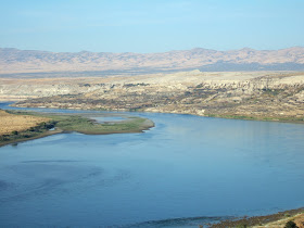
The downstream view gives one the sense of this powerful but controlled river. A huge force of water that surges through the dams turbines. One massive hydroelectric source.

A powerful river flowing northward at this location before it bends first west and then back to the south.
Note the distinct terrace in the distance along the valley side. 

The Grand Coulee dam was not the first dam at this location. During the ice age, the Okanogan ice lobe blocked the Columbia River in the same area. At that time a much larger lake formed than the current Lake Roosevelt. This lake backed all the way up to the Spokane area. The terraces pictured above were from later, smaller versions of the lake as the ice lobe progressively retreated to the north. The level terraces are remnants of the former lake bottoms that remain along the sides of the valley.
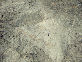
Evidence of the past presence of ice at Grand Coulee Dam can be seen on the striated granitic surfaces around the Crown Point viewing area. Just be careful not to fall off some of the cliffs!

Striated granite slab at Crown Point, Grand Coulee Dam

Tuesday, December 6, 2011

The Other Murrow Brother

Mercer Island in the Lake Washington would have been a great gravel mine resource if all those people hadn't moved there and covered up the deposit with houses. Its proximity to Seattle led to the island becoming a suburban community faster than the need for gravel. Its boost to suburbia along with other communities east of the lake was the construction of the first floating bridge in Washington State. Lake Washington is deep and wide enough that the most practical way to bridge the lake was a floating bridge.

It was a bold and I am sure to some a bit crazy sounding to build a floating bridge. But Lacey Murrow the Director of Highways pushed the idea and the first floating bridge was completed across the 200-foot deep section of Lake Washington in 1940. The bridge was named after Murrow in the 1960s after he died. A parallel floating bridge was built in the 1990s and named after Homer Hadley, the designer of the first bridge.

Murrow's leadership on bridge building in the 1930s greatly shaped many of the communities around Washington State. He was Director of Highways at the time of the building the bridges at Deception Pass at the north end of Whidbey Island. He also started the bridge across the Columbia just downstream of Grand Coulee Dam. The infamous Tacoma Narrows Bridge which did not not turn out so well initially was started under his directorship. He also set up the bridge tolling authority which led to the ability to pay for a number of other bridges around the state.

Lacey Murrow grew up in Blanchard, Washington and went to high school in Edison, Washington. His younger brother was Ed Murrow, the famous radio and television journalist who brought reports from Europe during WWII, and he took on Joseph McCarthy's activities in congress. The community hall in Blanchard is very proud of the Ed Murrow legacy, but his older brother did pretty well for Washington State as well.

Saturday, December 3, 2011

Huge Landslide at Whitebluffs


The White Bluffs along the east side of the Columbia River on the Hanford Reach National Monument are located across the river from the former towns of Hanford and Whitebluffs. The bluffs have been formed by the Columbia River down cutting and moving laterally against the deep silts and sands and old soil horizons that make up the bluffs. The northern portions of the bluffs are within the Hanford Reach National Monument created by President Bill Clinton.

I recently visited the northernmost slide area a few miles south of Highway 24. I had previously observed a tumble weed filled canal along Highway 24 leading towards the Hanford Reach Monument and speculated that the canal had previously been used to enhance wildlife populations but was no longer in use.

Tumble weed filled canal

The story of the canal became clearer while I was doing a bit of research on the Pleistocene and Pliocene sediments of the Pasco Basin. Indeed the canal had been used as a water conduit to create a wetland area on the Saddle Mountain National Wildlife Area in an area now part of the Hanford Reach National Monument. However, the introduction of water created perched ground water that flowed towards the steep bluffs along the river and water started to seep out at much greater volumes from seeps and springs along the white bluffs. The water greatly weakened the silt units on the bluff and a huge landslide was triggered.

Satellite overview of canal, wetland and landslide

As can be seen the slide area is two miles wide. This slide really caused some concerns about it being big enough that the river might get diverted toward some of the nuclear reactors that were used for weapons grade nuclear fuel production at the Hanford area. The water supply to the wetlands was cut off once this problem became apparent.  

View of large slide 

More typical slides into the river south of large slide
These slides were triggered by the river undermining the steep bluff

Another view with the typical slides in the foreground and the large slide in the distance
Buff colored layered silts at the top of the bluff are Missoula Flood deposits

Besides the landslides there are some other geologic features. One is that the entire White Bluffs area was submerged by flood waters from The Missoula Floods. This is one of those mind bending flood locations because the river is so far below. But as can be seen by the presence of Missoula Flood silts this was a quiet water area. The area flooded when water backed up at the narrow constriction at Wallula Gap model-of-ice-age-flood. Besides silt, the flood waters had ice bergs and the ice bergs contained rocks. Hence, while traversing across the top of the bluffs I came across angular ice rafted boulders and cobbles.

One-foot diameter granite boulder

Angular cobbles with silt.

The top of the large landslide area is lined with large sand dunes. The loose landslide sediments provide a supply of sand that is blown up the bluff face to the top of the bluff. The bluff itself acts as a barrier that causes the wind to rapidly accelerate as the air flows up and over the top edge of the bluff.

Sand dunes line the top of the bluff above the large  landslide complex

Sam and I look down the face of the dune at our shadows

Sam charges down the dune face

Sam takes in the view between runs down the dune

Mushroom growing within the dune field