Wednesday, November 30, 2011

Andesite from Washington State in Chicago

Even if your not that interested in architecture and urban design, you will become so when in Chicago. Lots of great buildings and public spaces. And some geology in some of those buildings HERE or for a great resource on stone and buildings check out David Williams' stories-in-stone.

One of my favorite buildings in Chicago is the Tribune Building with its flying buttresses on the upper floor and Gothic touches.

Tribune Building left of center with flying buttresses

Entrance to the Tribune Building

I noticed a feature on the walls of the Tribune Building I had not noticed before. On the walk up to the entrance pictured above note the protruding objects embedded in the walls. These objects also had caught the attention of some French visitors as well as my own attention. The protrusions were rocks, stones and bricks taken from other buildings or places and cemented into and onto the walls of the Tribune Building.

Stones and building materials embedded within walls of the Tribune Building 

Of course this led to a quest to find if there was a stone from Washington State. And sure enough there was a chunk of andesite from Washington State.

A piece of Washington in the Tribune Building

The Yellowstone hotspot was well represented with lava from Oregon, Idaho and Wyoming all possibly from the path of the hotspot over time:

Basalt from near the mouth of the Columbia River - I am not sure this is hot spot lava as it may be a more recent ocean floor basalt accreted to the North American margin.

Craters of the Moon basalt is very likely from the hotspot path

This piece of Wyoming looked is obsidian

One more rock in the walls of the building (there are 120 stones from around the world) is from Germany.

Basalt from Remagen Bridge across the Rhine River

A small group of Allied forces got a view of the Remagen Bridge in March 1944 and were surprised to see that it was still standing as the Germany forces had pulled back across the natural defense of the river and blown most of the bridges. An immediate change of invasion plans took place and Allied forces were immediately diverted to the Remagen Bridge before the Germans could destroy the bridge. My father was among those diverted and Remagen is where he began a full month on the front lines pushing into Germany. The bridge span did collapse from German shelling a few days after my father made the crossing, but the basalt support towers of the bridge are still standing.  

Tuesday, November 29, 2011

Some Water Views

I headed east for a combination of Turkey Day and other activities so posting opportunities have been limited as it should be. Departure from Seattle provided a great view of the third runway storm water pond for treating storm water run off from all that pavement.


Next we had a great view of a sediment plume in the South Sound between Seattle and Tacoma. Heavy rain fall had generated a plug of sediment discharged into the sound.

The source of a at least part of the sediment was evident in the muddy waters of Commencement Bay in Tacoma from the Puyallup River.

Then the ground was obscured with clouds but with a brief break to see Lake Tapps, a glacial carved depression on the uplands east of Tacoma.

Then a long stretch of clouds with only very fuzzy views of eastern Washington before seeing a nice meandering river somewhere in Montana. Not entirely sure where this was as it was a brief view of the ground before more clouds.


Things cleared up over North Dakota which was fun as I had been in North Dakota for a spell this summer and recognized many features. I liked the image below because it shows that North Dakota is a watery state. Lots of ice age kettles and depressions filled with water.


Tuesday, November 22, 2011

High River Levels Bring More Than Flood Risk

With heavy rains there is the risk of river flooding. But the another risk is channel migration. That is the risk that the channel of a river will shift. I recently assessed a reach of a northwest river for channel migration risk. Pretty simple evidence was visible to show that the river has been recently migrating.

Concrete foundation stem wall and concrete post supports

Undermined structure

undermined trees

Another home foundation

Utilities leading to where homes sites are now occupied by the river

It was not the first time I had assessed this particular river. Other reaches of this river have migrated much more dramatically over the past 50 years. At one reach upstream of the pictures above the river did a complete course shift in one storm event moving to a new channel nearly one mile away from the previous channel. The particular reach I was investigating was on a reach I first looked at ten years ago. I was on the opposite side of the river on that project and it was very clear the river was starting to migrate away from the property - good news for one side of the river is not so good for the other side.

The risk of flooding along this particular reach of river is low. The 100-year flood inundation area does not extend over much of the valley. But the risk of channel migration, a much more catastrophic problem, is obviously much greater.

Sunday, November 20, 2011

Doc Hastings and San Juan Island National Conservation Area Proposal

I have previously posted about a proposed San Juan Island National Conservation Area
national-conservation-area-and-san-juan
sam-crawford-proposes-supporting
whatcom-county-council-supports-san

Seems National Conservation Areas are among the things Doc Hastings Chair of the United States Congressal House Committee on Natural Resources does not care for.

Per McClatchy reporter Rob Hotakeinen:

"When Salazar suggested listing the San Juans and sites in eight other states as new wilderness and conservation areas, Hastings was quick to object.
He said Congress "has the sole authority" to decide which lands should be designated as wilderness "and which should instead be allowed to contribute to the full range of recreational, conservation, economic and resource benefits that carefully managed multiple-use lands provide."
Besides, Hastings said, the country can't afford any more public land."

Designation of Natural Conservation Areas as proposed does require an act of Congress as does the designation of wilderness areas. I know that Ken Salazar (Interior Secretary) is well aware of this. I am not sure what Mr. Hastings meant by "the country can't afford any more public land" as the lands in question are already owned by the public. In fact, part of the motivation for the San Juan designation is to better and more efficiently manage these lands.

The context of Hastings comments was in regards to a hearing on energy prodction from public lands and waters. Wilderness or conservation areas often trigger quick objections on the broad principle of not wanting to lock up lands from resource extraction. Hastings is an advocate for opening up more land for oil and gas development. Hence, wilderness proposals and conservation areas may get a bit of  broad brush treatment that is not necessarily reflective of the underlying geology. Not much chance of energy production from the small scattered islands and rocks in the San Juan Islands of northwest Washington and other than quarry rock not much mining value either.

Besides the energy issue, Hastings' comments regarding public land raises an over century old argument about public ownership of lands. It also revolves around the long standing struggle between local desires to extract revenue from Federal land and Federal control of those lands. In this regard, National Conservation Areas should have some appeal as it involves local planning efforts.  

It is a bit ironic that the background picture for the House Committee on Natural Resources web page has a picture of a wilderness area in Washington State as its background image http://naturalresources.house.gov/ and Doc Hastings' on web page includes a rolling set of pictures that includes a view of a Hanford Reach National Monument and a National Scenic Area.

Perhaps those images tell a truer story about the values that tend to prevail over the rhetoric and political dogma, otherwise pictures of open pit coal mines and other resource extraction images should be included.

Saturday, November 19, 2011

Hanford Sand Dunes

Sand dunes at Hanford area viewed from across the Columbia River at Ringold

Dunes are the faint light area in the satellite image (USGS)

Having grown up in eastern Washington I found that while traveling or living any distance from eastern Washington I frequently had to explain that eastern Washington is dry. In fact, large swaths of eastern Washington is desert. Parts of the east side basin are so dry that it is marginal for even sage brush to survive. And there are several areas of sand dunes in this dry landscape.

Hanford sand dunes and Columbia River.
Irrigated land on the east side of the river is irrigated via the Columbia Basin Project 

The largest dune field in eastern Washington is on the U.S, Department of Energy Hanford Reserve. A fair bit of the dune area at Hanford has become stabilized with vegetation hinting that for a time the area was even drier. But the core area of the Hanford dunes still contains a large active dune field. Public entrance to the dune fields at Hanford is restricted since the Hanford area was established as a nuclear materials production site. I got a glimpse of the Hanford dunes from across the river on a recent landslide inspection adventure.

The sand for these dunes is derived from from sands deposited by Missoula Flood waters that swept across the Hanford area depositing gravel, sand and silts. The dry climate and prevailing southwest winds has formed the dune fields which are slowly being blown into the Columbia River. Perhaps some of the sand from these dunes blown into the Columbia is now part of the sand dunes along the beaches of the southwest Washington coast. 

Thursday, November 17, 2011

Great Cattle Drives of Eastern Washington


The great cattle drive: Dalles, Oregon to
the Cariboo Mines of British Columbia 1862

Back in high school I took a class called Novel taught by Jim Deatherage. We read a variety of novels some of which I still remember very clearly. For a western novel we read A Thousand for the Cariboo by Bill Gulick. Gulick took the story of Andrew Splawn's cattle drive from the Dalles, Oregon to the Cariboo Country of British Columbia and turned it into a novel. I loved the story, and should add that Jim Deatherage ranked as one of the greatest teachers I ever had.

Gulick's wife Jeanne came across a self-published book by Andrew Splawn titled KA-MI-AKIN The Last Hero of the Yakimas that was published in 1917 in a second hand book shop. The book includes Splawn's account of the cattle drive from the Dalles, Oregon to Barkerville, British Columbia. Gulick and other historians have cited Splawn's accounts.

So I tracked down a print of A.J. Splawn's KA-MI-AKIN The Last Hero of the Yakimas in part because I am very interested in first hand accounts as to what the Washington landscaped once looked like. Splawn moved to what is now the Goldendale area in 1860 from the Willamette Valley at age 16. This was just two years after the Yakima War that had swept across eastern Washington.

In regards to Kamiakin, Splawn does not disappoint. His writing is not a researched history, it is a history as he remembers it and and as told by people that he knew that participated in the treaty negotiations and the fighting on both sides. Splawn met Kamiakin several years after the war and had several encounters with Moses (moses-epic-figure-of-19th-century) another important historic figure that shaped our state.

Though the book is titled KA-MI-AKIN, the story of the great Yakima leader is only the early part of the book. This book is a first hand account of the post fur trade west. The book is mix of stories of early settlement farming, mining and the great cattle drives. The Pacific Northwest cattle drives were epic and many a western novel and movie is based on the life that Splawn wrote about. He is frequently referenced as he provided first person accounts of cattle drives and meetings he had with various Indians, early pioneers, and military leaders.

I traced a couple of Splawn's cattle drives. He made the epic Dalles to the Cariboo trip more than once and that route is shown above. Note the drive is approximately 1,000 miles. His first trip included over wintering the cattle in British Columbia - a learning experience for an 18 year old. He also drove cattle from the present day Selah area to Lewiston, Idaho shown below. The purpose of these drives was to take cattle directly to the mines to feed the miners. At the time there were no towns in Washington along the routes driven and the routes would best be described as lawless and very risky. They passed through significant tracts of land controlled by Indians that had yet to agree to ceding land and many of the Europeans and Americans were flat out criminals and at the time there was no court system to speak of in Washington Territory and a fairly weak one in British Columbia. Mining in north Washington, Idaho and the Cariboo drove much of the early agriculture in eastern Washington and is what made Splawn a successful businessman.

Splawn's Selah, Washington to Lewiston, Idaho drive
Number notations below
1 - Selah
2 - Cold Creek at present day Hanford
3 - Whitebluffs crossing of the Columbia River
4 - Washtucna Coulee including a stop at two lakes in the coulee one near present day Connell the second near Kahlotus.
5 - Palouse River - they followed the river from just upstream of where it cuts into a narrow gorge to Union Flat Creek
6 - Union Flat Creek. A long creek valley that took the cattle up to Union Flat on the plateau south of Pullman and above Lewiston.
7 - Lewiston. The drive actually continued past Lewiston to the Boise Basin as they wanted better prices for the cattle than what was offered in Lewiston.  

Tuesday, November 15, 2011

Mini Badland Southeast of Bridgeport

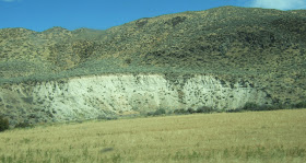
Highway 174 from Grand Coulee to Bridgeport takes one up onto the northeast part of the Watterville Plateau and glacier scoured landscapes. The road then drops down into the East Foster Creek drainage and follows the drainage back down to the Columbia River to Bridgeport and Chief Joseph Dam. This valley has some mini badlands. Bare white/gray silt bluffs are scattered along the valley like old dump piles of soil, and the same silts area exposed along steep cut bank slopes adjacent to the creek.


Level terraces along the valley sides provide a clue as to the origin of the silt that makes up the bad land. Once the Okanogan ice lobe retreated back off the Watterville Plateau it still dammed the Columbia River creating a lake that extended up stream and up the valley the road passes down. That lake was filled with silt from finely ground rock from the glacial ice. The fine silts settled on the lake bed as a thick blanket of silt. Subsequent erosion has left a mini bad land and the terraces in the East Foster Creek drainage. The soil properties of the silt are somehow not conducive to plant cover at least in this local climate.

Lake terrace is the level line bench on the valley slope.

The lake formed by the Okanogan ice lobe varied in size and depth depending on how far the ice extended to the south and how thick the ice was. Sediments from this glacial lake are a common feature all along the Columbia River valley upstream from Chief Joseph dam. As posted previously the lake also must have had some big ice bergs as some huge boulders are scattered within the lake sediments glacial-erratics-near-grand-coulee-dam. Another version of the lake played a key role in shaping and directing the Missoula Floods across eastern Washington as water from the lake spilled out of the valley south across the landscape.


Monday, November 14, 2011

Missoula Forest Fire 2011

Wild land fire east of Missoula, Montana

Forest fires near Missoula, Montana area are not uncommon. The forest in this area is subject to forest fires as many years there is a distinct dry period when the forest becomes fire susceptible. The forest is very similar to forest areas of eastern Washington; however, the recurrence of fires may be more frequent in Montana as lightning strikes are more common in this area.

The picture above shows that a forest fire does not mean that the entire forest is killed. Large areas of trees from this burn survived as the fire was limited to the understory and most of the trees would likely survive. In the picture above the fire was burning down hill, into a very light wind, the air temperature was not too hot as it was late in the day, trees are well spaced, and the understory was not thick. Other areas in this fire were burned more intensely - places with thicker forest, places where the fire burned when the air was hotter, and places where wind and topography drove the flames higher.

Having inspected burned areas in the past as well as this fire, I have learned to take reported acres burned in a bit different perspective. A 50,000 acre fire does not mean all the trees within the 50,000 acres were burned. Fire is an important part of forest landscapes and land management, And political sometimes a hot issue (pun sort of intended). Post fire impacts to geomorphic processes are an interesting subject that has been gaining attention with studies of post fire run off and sediment loads in stream systems. It turns out that the intensity of the fire makes a big difference in post fire rain water infiltration. Very intensely burned areas not only kill all the trees but also are subject to higher flood risk due not only the loss of tree canopy but can also be at risk due to soil alteration from the heat.

Clark and his dog with fire on the slope above the Clark Fork

Saturday, November 12, 2011

Winter, Wind and Whidbey Island

Sunshine and gravel bars on the Sauk River

Winter has arrived. It is the time of year to routinely check weather forecasts for planning field work and adventures. I did very well this week with a trip up to the Sauk River in the North Cascades on sunny Thursday allowing for pleasant conditions while trying to figure out somewhat perplexing problem. Felt quite smug as Friday was a far different day. Wind and a couple of rounds of sleet in Bellingham with snow levels dropping down to between 1,500 feet and 2,000 feet.

Big winds surged down the Strait of Juan de Fuca. Cliff Mass did a write up on the winds HERE


Wind chart via Cliff Mass and UW.

I was tempted to head down to the west shore of Whidbey Island to see how big the wind generated waves were. But I had some reports to review and research and writing. If I had I may have run into Hugh Shipman. He did make the trip and has provided several posts with pictures HERE. So I got to stay cozy and take a virtual trip.

Thursday, November 10, 2011

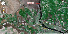
End of the Road at Ringold Landslides


I recently took a trip up along the east bank of the Columbia River across from the Hanford area. After passing by a couple of the water slides and man made waterfalls end-of-line-for-canals, the road comes to an abrupt end.

End of the Ringold Road.

The Columbia River Road ends at a landslide.
The site is reached via Road 68 off of Highway 12/Interstate 182 northwest of Pasco

The road formerly continued north along the river before it was closed I believe in the 1960s. Irrigation on the plateau above caused groundwater to become perched on the silts of the Ringold Formation bluffs above the river triggering a series of landslides closing the riverside road.

Landslide scarps on the Ringold bluffs.
Orchards and other irrigated crop land is located above.
Note the green wetland on the mid slope.

The slopes were already steep and potentially unstable with some old landslides before the irrigation began. The slope is steep from toe erosion from the Columbia River. The irrigation has simply caused the frequency of landslides on this reach of bluffs to increase with slopes failing that otherwise would not because of the added water.

Fractured blocks on landslide surface with Columbia River below
Steam plume is from Washington Public Power Supply System nuclear power plant at Hanford

Silt/clay unit of Ringold Formation. Besides acting as a perching,
the unit is very weak from wetting and drying.
One of several headwall scarps exposing silts and clays

Finely layered silts in block on the slide surface

Volcanic ash unit
Volcanic ash

The Ringold Formation is well exposed all along the bluffs on the east side of the Columbia River in the Pasco Basin. Many of the silt units are decidedly white. These light colored silts along with units of volcanic ash give the area its name, White Bluffs. The formation overlies the older Miocene Columbia River Basalt Group and is overlain by Plio-Pleistocene alluvial and soil sediments. The age of the formation is estimated to range from 8.5 to 3.4 million years old. The deposits are are generally not very lithified. The sediments are derived from the ancient Columbia River, Snake River, Palouse River and a few other streams that flowed into the Pasco Basin. The formation has a fair bit of volcanic ash and deeply weathered soils. 

The presence of the Ringold Formation hints that the Pasco Basin in south central Washington has been a subsiding basin since at least the end of the Miocene and given the thickness of the underlying basalts in the basin probably for millions of years before that. The preponderance of silts and lake deposits in the upper portion of the formation where the slides are taking place may be the result of changes in the Columbia River gradient down stream of the Pasco Basin. The Columbia River flows through the Cascade Mountains downstream through the Columbia River Gorge. It is easy to imagine a scenario whereby the Columbia would have been blocked by lava flows that would have backed the river up into a lake covering much of the Pasco Basin, but there are alternative mechanisms that could have changed the gradient as well. 

The Columbia River Road ends at a spot where landslides soils deeply buried the road, but there are plenty of more landslides to the north beyond the road closure.

The end of the road can be seen in the USGS image above as well as section of the old road to the north

Active slides below irrigated land to the north
(USGS image)

Further north the slide area can be accessed via Columbia River Road from the north via Fir Road. A few homes have been built on a bench area above the river. I have not checked this reach out but the green swath to the east of the homes indicates perched groundwater on the slope.

Homes on bench area above river approximately half mile north of active slide area

Wednesday, November 9, 2011

Hay Rolls on Right-of-Ways

Hay rolls on highway right-of-way, North Dakota

I spent some time this past summer on the northern Great Plains of the United States. A common feature I observed was cut hay rolls along the right-of-way of highways in Nebraska, the Dakotas and Montana. Not something one sees in Washington State. In part this is because most hay production in eastern Washington depends on irrigation and in western Washington farm land is fairly limited compared to the plains and even then summers are often too dry for much hay production. Regardless, I liked seeing the land along highway right-of-ways utilized. Given the need to cut back the jungle in western Washington, perhaps Christmas tree farms on the right-of-ways would work.

Tuesday, November 8, 2011

Theodore Roosevelt and Landslides

Theodore Roosevelt National Park, North Dakota

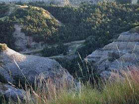
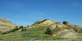
For geologists badlands are great fun. Lots of well exposed formations and raw geomorphic processes to behold. My early geology years were all about hard rocks, mines and metamorphic processes. But I found a recent trip into some badlands had me very enthusiastic about the work I currently do on slope stability. Lots of great landslides to check out.

This bad land area is not in Washington State. Theodore Roosevelt bought and operated a ranch here in these badlands. After his first wife died he came here to heal. He drew great inspiration from this landscape. Douglas Brinkley in Wilderness Warrior titled a chapter of the book Cradle of Conservation: the Elkhorn Ranch of North Dakota. That conservation ethic had a profound impact on the Washington State landscape we know today: 8 National Wildlife Refuges and 8 National Forests covering tens of thousands of acres were set aside in Washington State by Roosevelt.

The site of Roosevelt's ranch is now part of Theodore Roosevelt National Park in southwest North Dakota. With the near complete demise of the bison on the Great Plains, the area was very attractive for cattle ranchers in the late 1800s as the grasses had been ungrazed for several years and their had been no droughts or terrible cold spells. 

Besides the history and alien like landscape, the park is full of landslides.

Landslide block. The hill in the foreground is coherent detached slide block from the slope on the left.

Another slide block with classic back slope from rotation

Cracks on road surface indicating an ongoing problem

Dip on road surface and patches mark the outer edge of a large failure involving the road.

Same failure looking down from above along the edge of the slide area.
The road was clearly constructed across an old slide surface

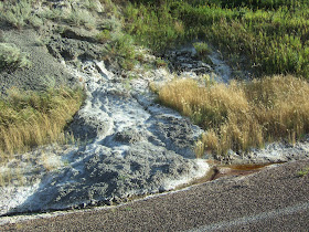
Expansive clay within the slide area. Bentonite swells when wet making it useful for sealing wells and landfills but a real problem for slope stability.  

This section of road is in real trouble at another slide location

Yet another slide in the early stages beginning to fracture the road

View to Little Missouri River from the headwall of new slide

This slide did not impact a road but made a trail a bit tricky

Inverted topography: Southwest North Dakota is not flat, the hills are just downward